world.wikisort.org - Algeria
Laghouat (Arabic: ولاية الأغواط) is one of the forty-eight provinces (wilaya) of Algeria. It is located in the north central part of Algeria. The province borders Tiaret Province to the north, El Bayadh Province to the west, Ghardaia Province to the south and Djelfa Province to the east. The capital of the province is Laghouat City. The province is famous for palm trees and livestock.
This article needs additional citations for verification. (January 2021) |
Laghouat Province
ولاية الأغواط | |
|---|---|
Province | |
  | |
 Map of Algeria highlighting Laghouat | |
| Coordinates: 33°48′N 2°53′E | |
| Country | |
| Capital | Laghouat |
| Area | |
| • Total | 25,057 km2 (9,675 sq mi) |
| Population (2008)[1] | |
| • Total | 477,328 |
| • Density | 19/km2 (49/sq mi) |
| Time zone | UTC+01 (CET) |
| Area Code | +213 (0) 29 |
| ISO 3166 code | DZ-03 |
| Districts | 10 |
| Municipalities | 24 |
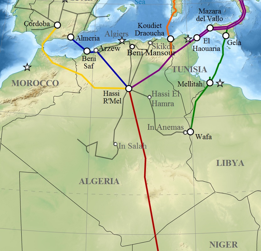
The province is a large producer of natural gas, containing important drilling sites in the region of Hassi R'Mel. Large reserves of natural gas have allowed Algeria to occupy an important position in the global energy market.
Geography
Location and Nature
Located at an average altitude of 750 m above sea level, Laghouat Province is part of the Saharan Atlas Mountain range with some peaks rising above 2,000 m. For example, the Djebel Amour range reaches a top height of about 2,200 m.
Laghouat is nearly 400 km away from Algiers, the capital of Algeria.
The area's orchards, buildings and mosques span across a landscape of vast steppes, mountains, and pastures. The largest tributary in the area is the Chelif River and M'zi River, which originate from the Wadi Al-Tawil mountains.
The area is characterized by its pastoral, agricultural and mountainous character. It also contains an industrial region located at Hassi R'mel.

Terrain
The province of Laghouat is located between Hautes Plaines and the desert foothills of the Saharan Atlas mountain range. It is surrounded on the two sides by the Amour Range west of the province and the mountains of Ouled Nile to the east. The province is divided into three main geographical regions: the Saharan Atlas mountains, the Steppe Plains, and the Desert.
Saharan Atlas
The Saharan Atlas Mountain Range is located in the northwest of the province, to the north of the Djebel Amour mountains. The Saharan Atlas mountains reach heights between 1000 and 1700 meters above sea level. We can distinguish them into two sub-regions which include the High Highlands area in the north and a mountainous area in the south. The districts of Gueltet Sidi Saâd, Aflou District, Brida District, El Ghicha District and Oued Morra District are located in this region. The most important characteristic of this area is that it is the source of the most significant rivers in Algeria, including the Chelif River, the Wadi el-Taweel and the Wadi Djedi through its tributary the M'zi River. It is distinguished by the presence of the green dam forests that blend into the grassy Steppe region.
Steppe
These grassland plains are located in the center of the province and are between 700 and 1000 meters above sea level. It is known as a grazing area as it contains many steppe plants and herbs. This region includes most of the province's vegetation, not counting the green dam forests located in the mountainous region. The Steppe region includes the districts of Sidi Makhlouf, Laghouat District, and northern Ain Madhi.
Desert
The southern part of Laghouat province is a desert plateau. This area includes the Hassi R'Mel District, the southern part of the Ksar El Hirane District and Ain Madhi District. It is distinguished by low vegetation cover characterized by Peganum plants. There are some hills here that are distinguished by various trees including the Ziziphus spina-christi and Pistacia atlantica. Various herbs and flowers are abundant here in the springtime.
History
The province was created by the Oasis and Tiaret departments in 1974.
In 1984 Ghardaïa Province was carved out of the territory of Laghouat.
Administrative division
The province is divided into 10 districts (daïras), which are further divided into 24 communes or municipalities.
Districts

Communes
- Aflou
- Aïn Madhi
- Aïn Sidi Ali
- Beidha
- Brida
- El Assafia
- El Ghicha
- El Houaita
- Gueltat Sidi Saad
- Hadj Mechri
- Hassi Delaa
- Hassi R'Mel
- Kheneg
- Ksar El Hirane
- Laghouat
- Mekhareg (Benacer Ben Chohra)
- Oued Morra
- Oued M'Zi
- Sebgag
- Sidi Bouzid
- Sidi Makhlouf
- Tadjemout
- Tadjrouna
- Taouila
Economy
Transportation
| Index | The number | Length |
| National Road | 3 | 403 km |
| Number of Airports | 2 | |
| Railways | - | 0 km |

Laghouat Province contains three main roadways:
- The Trans-Saharan Road (N1): This international road links Algiers to Lagos, Nigeria in the south. It also connects the city of Laghouat with Djelfa in the north and Ghardaia in the south.
- National Road No. (23): This road connects Laghouat to Tiaret and the western port city of Mostaganem.
- National Road No. (47): Connects Aflou with El Bayadh and Aïn Séfra in the southwest.
The state has two airports, one of which is a local airport used mainly to transport pilgrims. The Laghouat Airport is officially called Moulay Ahmed Medeghri Airport and is named after the martyr Moulay Ahmed Madgari. The second airport, Hassi R'mel, is mainly used by the Sonatrach National Fuel Company to transport equipment, tires, experts, and contractors.
Energy
Laghouat Province is considered to be the second most important energy mandate in Algeria after Ouargla Province, because it contains one of the most important gas fields in Africa. This gas field is in the region of Hassi R'mel and contains many electricity production stations. These are located in the Telegmat region near Hassi R'mel and Kheneg. These areas also contain the largest solar PV plant in Algeria with a capacity of 60 MW.
CPV EKP solar power station
The CPV EKP solar power station is located 5 km from the municipality of Kheneg and 10 km from Laghouat in Algeria.

The station sits on an area of 120 hectares and, on average, produces more than 300 MWh of electricity per day. It contains more than 240 thousand solar panels distributed over 5460 matrices, 2040 triple level junction boxes, 120 inverters, and 60 transformers. It is connected to a 60 kV high-voltage electricity transmission network by the lifting station, which contains 3 transformers with a capacity of 20 MVA each.
Livestock raising
Livestock in Laghouat province number around 4,000,000 cattle, sheep and goats. Sheep rank first in population with over 3 million heads, followed by goats, cows, camels, and horses (including mules and donkeys).[2][3]
Tourism
The province's most popular tourist area is the district of Kef El Melh (the mountain of salt). It is located in the municipality of Tadjrouna near the border with El Bayadh Province. The largest tourist hotspot in the district is the Kordan Palace, or Crown Angle. Other tourist areas and natural sights include the Al-Ghaisheh, Taouila, Lalmaya, Ein Sefsifah, and Al-Huwaita. Laghouat is home to the Talemzane crater, or Madna Crater, a depression resulting from the impact of an ancient meteorite. It is the second largest crater in the world (based on depression circumference) and is found in the municipality of Hassi Delaa in the south.[4]
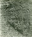
- Rock carvings El Ghicha


- Rock carvings Sidi Makhlouf


See also
References
- Office National des Statistiques, Recensement General de la Population et de l’Habitat 2008 Archived 2008-07-24 at the Wayback Machine Preliminary results of the 2008 population census. Accessed on 2008-07-02.
- Laghouat: Opération de vaccination du bétail contre la brucellose Algerie Confluences Algerie Confluences
- Algérie Presse Service - Près de 217,000 têtes de bétail vaccinées contre la brucellose à Laghouat <! - bot generator address ->
- Bellhai, D. (2012). "New Studies About The Maadna Impact Crater" (PDF). Lunar and Planetary Science Conference. 32: 1111, 1112 – via USRA (Universities Space Research Association).
URL: https://en.m.wikipedia.org/wiki/Laghouat_Province
|  | |
Capital: Laghouat | ||
| Districts |
|  |
| Communes |
| |
Authority control | |
|---|---|
| General |
|
| National libraries | |
| Other |
|
На других языках
- [en] Laghouat Province
[ru] Лагуат (вилайет)
Лагуа́т[2][3] (араб. ولاية الأغواط ) — вилайет[4] в центральной части Алжира. Административный центр вилайета — город Лагуат. Лагуат в переводе означает «оазис».Другой контент может иметь иную лицензию. Перед использованием материалов сайта WikiSort.org внимательно изучите правила лицензирования конкретных элементов наполнения сайта.
WikiSort.org - проект по пересортировке и дополнению контента Википедии