world.wikisort.org - Norway
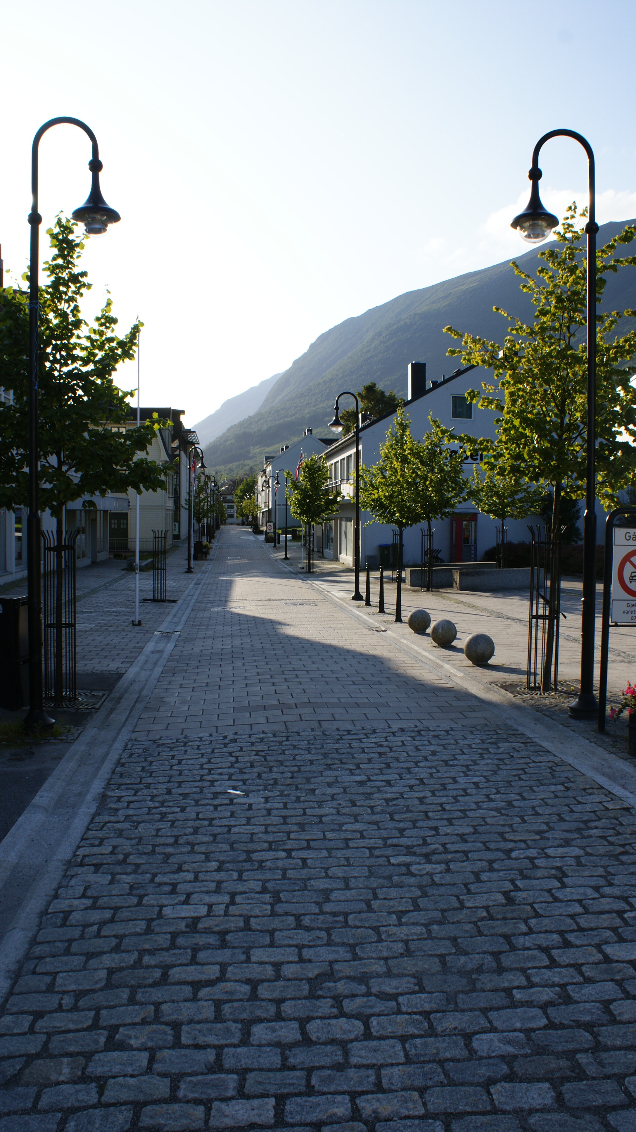
![]() Ørsta (help·info) is a municipality in Møre og Romsdal county, Norway. It is part of the Sunnmøre region of Western Norway. The administrative centre of the municipality is the village of Ørsta. Other villages in the municipality include Hovdebygda, Flåskjer, Liadal, Urke, Barstadvik, Åmdalen, Follestaddalen, Nordre Vartdal, Vartdal, Sæbø, Sætre, Store-Standal, and Ytre Standal.
Ørsta (help·info) is a municipality in Møre og Romsdal county, Norway. It is part of the Sunnmøre region of Western Norway. The administrative centre of the municipality is the village of Ørsta. Other villages in the municipality include Hovdebygda, Flåskjer, Liadal, Urke, Barstadvik, Åmdalen, Follestaddalen, Nordre Vartdal, Vartdal, Sæbø, Sætre, Store-Standal, and Ytre Standal.
Ørsta kommune | |
|---|---|
Municipality | |
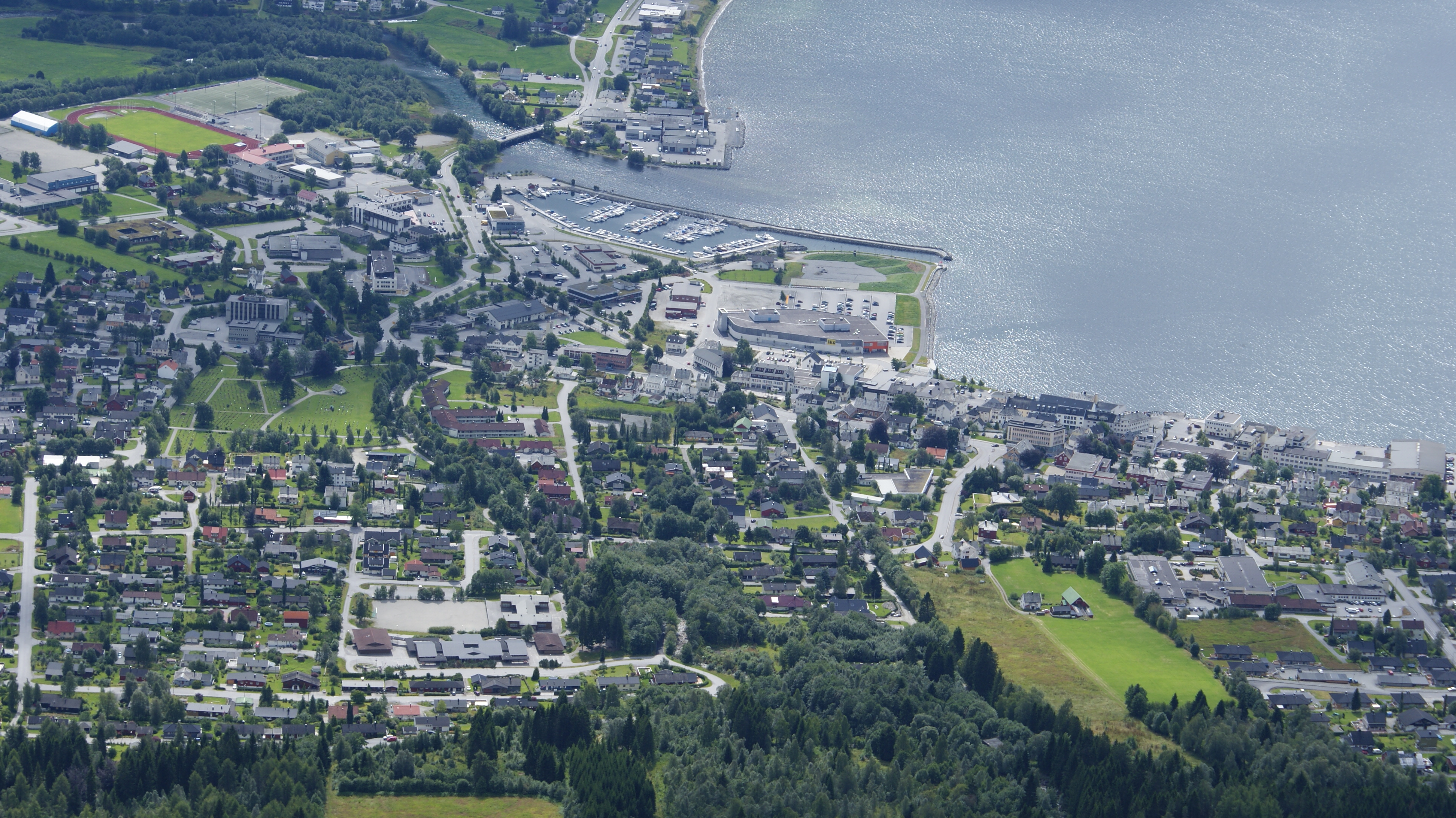
 View of the urban areas of Ørsta | |
 Flag  Coat of arms  Møre og Romsdal within Norway | |
 Ørsta within Møre og Romsdal | |
| Coordinates: 62°12′01″N 06°07′56″E | |
| Country | Norway |
| County | Møre og Romsdal |
| District | Sunnmøre |
| Established | 1 Aug 1883 |
| • Preceded by | Volda Municipality |
| Administrative centre | Ørsta |
| Government | |
| • Mayor (2015) | Stein Aam (Sp) |
| Area | |
| • Total | 661.61 km2 (255.45 sq mi) |
| • Land | 649.65 km2 (250.83 sq mi) |
| • Water | 11.96 km2 (4.62 sq mi) 1.8% |
| • Rank | #171 in Norway |
| Population (2022) | |
| • Total | 10,833 |
| • Rank | #105 in Norway |
| • Density | 16.7/km2 (43/sq mi) |
| • Change (10 years) | |
| Demonym | Ørsting[1] |
| Official language | |
| • Norwegian form | Nynorsk |
| Time zone | UTC+01:00 (CET) |
| • Summer (DST) | UTC+02:00 (CEST) |
| ISO 3166 code | NO-1520 |
| Website | Official website |
The 662-square-kilometre (256 sq mi) municipality is the 171st largest by area out of the 356 municipalities in Norway. Ørsta is the 105th most populous municipality in Norway with a population of 10,833. The municipality's population density is 16.7 inhabitants per square kilometre (43/sq mi) and its population has increased by 4.2% over the previous 10-year period.[3][4]
General information
The municipality of Ørsta was established on 1 August 1883 when it was separated from Volda Municipality. The initial population was 2,070. On 1 January 1893, the Ytrestølen farm (population: 13) was transferred from Ørsta to Volda. During the 1960s, there were many municipal mergers across Norway due to the work of the Schei Committee. On 1 January 1964, the municipality of Ørsta (population: 6,209) was merged with the neighboring municipalities of Hjørundfjord (population: 1,728) and Vartdal (population: 1,315) to form a new, larger municipality of Ørsta.[5] On 1 January 2020, the Bjørke and Leira areas of Ørsta were transferred to the neighboring Volda Municipality.[6]
Name
The municipality is named after the Ørstafjorden (Old Norse: Œrstr). The meaning of the name is unknown. Before 1918, the name was written Ørsten.[7]
Coat of arms
The coat of arms was granted on 13 July 1984. The arms consist of three white or silver diamonds on a blue background. The three diamonds represent the mountains reflecting in the waters of the fjord.[8]
Museums
The Brudavoll Farm, part of the Sunnmøre Museum Foundation, is located about 5 km (3.1 mi) from the village of Ørsta.[9]
Churches
The Church of Norway has three parishes (sokn) within the municipality of Ørsta. It is part of the Søre Sunnmøre prosti (deanery) in the Diocese of Møre.[10]
| Parish (sokn) | Church name | Location of the church | Year built |
|---|---|---|---|
| Ørsta | Ørsta Church | Ørsta | 1864 |
| Vartdal | Vartdal Church | Nordre Vartdal | 1876 |
| Hjørundfjord | Hjørundfjord Church | Sæbø | 1880 |
Geography


Of the total area, 48% (386 square kilometres or 149 square miles) of the municipality is at an altitude of 600 metres (2,000 ft) or more above sea level. Apart from the mountains, Ørsta's dominant geographical feature is fjords: Storfjorden in the north, Vartdalsfjorden, Ørstafjorden in the west, and Hjørundfjorden in the east. Only in the south is it connected by land to neighbouring Volda Municipality. Otherwise, it borders the municipalities of Sula in the north, Hareid and Ulstein (by sea only) in the west, Sykkylven to the northeast, and Stranda to the southeast.
The municipality is also the heartland of the Sunnmørsalpene mountains, a particularly rugged and wild area of mountains in the southern part of Møre og Romsdal county. Prolific peaks include Slogen at 1,564 metres (5,131 ft), Skårasalen at 1,542 metres (5,059 ft), Kolåstinden at 1,432 metres (4,698 ft), Ramoen at 1,419 metres (4,656 ft), Saudehornet at 1,303 metres (4,275 ft), and Romedalstinden at 1,295 metres (4,249 ft).
Economy
Important sectors are mechanical industry and furniture manufacturing, agriculture, commercial fishing, and aquaculture. The first two are predominant in the village of Ørsta while agriculture dominates in adjacent valleys like the Follestaddalen, Åmdalen, and Bondalen valleys. On the other hand, the northern part of the municipality has strong maritime traditions, with Vartdal being the home of one of the largest factory trawler fleets in Norway.
Government
All municipalities in Norway, including Ørsta, are responsible for primary education (through 10th grade), outpatient health services, senior citizen services, unemployment and other social services, zoning, economic development, and municipal roads. The municipality is governed by a municipal council of elected representatives, which in turn elect a mayor.[11] The municipality falls under the Møre og Romsdal District Court and the Frostating Court of Appeal.
Municipal council
The municipal council (Kommunestyre) of Ørsta is made up of 33 representatives that are elected to four year terms. The party breakdown of the council is as follows:
| Party Name (in Nynorsk) | Number of representatives | |
|---|---|---|
| Labour Party (Arbeidarpartiet) | 4 | |
| Progress Party (Framstegspartiet) | 5 | |
| Green Party (Miljøpartiet Dei Grøne) | 1 | |
| Conservative Party (Høgre) | 3 | |
| Christian Democratic Party (Kristeleg Folkeparti) | 1 | |
| Centre Party (Senterpartiet) | 16 | |
| Socialist Left Party (Sosialistisk Venstreparti) | 2 | |
| Liberal Party (Venstre) | 1 | |
| Total number of members: | 33 | |
| Party Name (in Nynorsk) | Number of representatives | |
|---|---|---|
| Labour Party (Arbeidarpartiet) | 5 | |
| Progress Party (Framstegspartiet) | 5 | |
| Green Party (Miljøpartiet Dei Grøne) | 1 | |
| Conservative Party (Høgre) | 7 | |
| Christian Democratic Party (Kristeleg Folkeparti) | 4 | |
| Centre Party (Senterpartiet) | 8 | |
| Socialist Left Party (Sosialistisk Venstreparti) | 1 | |
| Liberal Party (Venstre) | 2 | |
| Total number of members: | 33 | |
| Party Name (in Nynorsk) | Number of representatives | |
|---|---|---|
| Labour Party (Arbeidarpartiet) | 7 | |
| Progress Party (Framstegspartiet) | 6 | |
| Conservative Party (Høgre) | 8 | |
| Christian Democratic Party (Kristeleg Folkeparti) | 4 | |
| Centre Party (Senterpartiet) | 5 | |
| Socialist Left Party (Sosialistisk Venstreparti) | 1 | |
| Liberal Party (Venstre) | 2 | |
| Total number of members: | 33 | |
| Party Name (in Nynorsk) | Number of representatives | |
|---|---|---|
| Labour Party (Arbeidarpartiet) | 7 | |
| Progress Party (Framstegspartiet) | 10 | |
| Conservative Party (Høgre) | 2 | |
| Christian Democratic Party (Kristeleg Folkeparti) | 3 | |
| Centre Party (Senterpartiet) | 7 | |
| Socialist Left Party (Sosialistisk Venstreparti) | 2 | |
| Liberal Party (Venstre) | 2 | |
| Total number of members: | 33 | |
| Party Name (in Nynorsk) | Number of representatives | |
|---|---|---|
| Labour Party (Arbeidarpartiet) | 6 | |
| Progress Party (Framstegspartiet) | 8 | |
| Conservative Party (Høgre) | 2 | |
| Christian Democratic Party (Kristeleg Folkeparti) | 3 | |
| Centre Party (Senterpartiet) | 8 | |
| Socialist Left Party (Sosialistisk Venstreparti) | 4 | |
| Liberal Party (Venstre) | 2 | |
| Total number of members: | 33 | |
| Party Name (in Nynorsk) | Number of representatives | |
|---|---|---|
| Labour Party (Arbeidarpartiet) | 8 | |
| Progress Party (Framstegspartiet) | 5 | |
| Conservative Party (Høgre) | 4 | |
| Christian Democratic Party (Kristeleg Folkeparti) | 6 | |
| Centre Party (Senterpartiet) | 9 | |
| Socialist Left Party (Sosialistisk Venstreparti) | 4 | |
| Liberal Party (Venstre) | 3 | |
| Total number of members: | 39 | |
| Party Name (in Nynorsk) | Number of representatives | |
|---|---|---|
| Labour Party (Arbeidarpartiet) | 7 | |
| Progress Party (Framstegspartiet) | 4 | |
| Conservative Party (Høgre) | 4 | |
| Christian Democratic Party (Kristeleg Folkeparti) | 6 | |
| Centre Party (Senterpartiet) | 13 | |
| Socialist Left Party (Sosialistisk Venstreparti) | 2 | |
| Liberal Party (Venstre) | 3 | |
| Total number of members: | 39 | |
| Party Name (in Nynorsk) | Number of representatives | |
|---|---|---|
| Labour Party (Arbeidarpartiet) | 7 | |
| Progress Party (Framstegspartiet) | 2 | |
| Conservative Party (Høgre) | 4 | |
| Christian Democratic Party (Kristeleg Folkeparti) | 8 | |
| Centre Party (Senterpartiet) | 11 | |
| Socialist Left Party (Sosialistisk Venstreparti) | 4 | |
| Liberal Party (Venstre) | 2 | |
| Cross-party list for Ørsta (Tverrpolitisk liste for Ørsta) | 1 | |
| Total number of members: | 39 | |
| Party Name (in Nynorsk) | Number of representatives | |
|---|---|---|
| Labour Party (Arbeidarpartiet) | 8 | |
| Progress Party (Framstegspartiet) | 3 | |
| Conservative Party (Høgre) | 6 | |
| Christian Democratic Party (Kristeleg Folkeparti) | 8 | |
| Centre Party (Senterpartiet) | 6 | |
| Socialist Left Party (Sosialistisk Venstreparti) | 2 | |
| Liberal Party (Venstre) | 4 | |
| Cross-party list for Hjørundfjord (Tverrpolitisk liste for Hjørundfjord) | 2 | |
| Total number of members: | 39 | |
| Party Name (in Nynorsk) | Number of representatives | |
|---|---|---|
| Labour Party (Arbeidarpartiet) | 8 | |
| Progress Party (Framstegspartiet) | 1 | |
| Conservative Party (Høgre) | 5 | |
| Christian Democratic Party (Kristeleg Folkeparti) | 8 | |
| Centre Party (Senterpartiet) | 7 | |
| Socialist Left Party (Sosialistisk Venstreparti) | 2 | |
| Liberal Party (Venstre) | 3 | |
| Cross-party election list for Ørsta (Tverrpolitisk valliste for Ørsta) | 3 | |
| Cross-party election list for Hjørundfjord (Tverrpolitisk valliste for Hjørundfjord) | 2 | |
| Total number of members: | 39 | |
| Party Name (in Nynorsk) | Number of representatives | |
|---|---|---|
| Labour Party (Arbeidarpartiet) | 7 | |
| Conservative Party (Høgre) | 6 | |
| Christian Democratic Party (Kristeleg Folkeparti) | 8 | |
| Centre Party (Senterpartiet) | 8 | |
| Socialist Left Party (Sosialistisk Venstreparti) | 1 | |
| Liberal Party (Venstre) | 4 | |
| Cross-party election list for Ørsta (Tverrpolitisk valliste for Ørsta) | 2 | |
| Cross-party list for Hjørundfjord (Tverrpolitisk liste for Hjørundfjord) | 3 | |
| Total number of members: | 39 | |
| Party Name (in Nynorsk) | Number of representatives | |
|---|---|---|
| Labour Party (Arbeidarpartiet) | 6 | |
| Conservative Party (Høgre) | 3 | |
| Christian Democratic Party (Kristeleg Folkeparti) | 9 | |
| New People's Party (Nye Folkepartiet) | 2 | |
| Centre Party (Senterpartiet) | 10 | |
| Socialist Left Party (Sosialistisk Venstreparti) | 1 | |
| Liberal Party (Venstre) | 4 | |
| Cross-party Nature and Environment List (Tverrpolitisk Natur- og Miljøvernliste) | 1 | |
| Cross-party list for Hjørundfjord (Tverrpolitisk liste for Hjørundfjord) | 3 | |
| Total number of members: | 39 | |
| Party Name (in Nynorsk) | Number of representatives | |
|---|---|---|
| Labour Party (Arbeidarpartiet) | 8 | |
| Conservative Party (Høgre) | 2 | |
| Christian Democratic Party (Kristeleg Folkeparti) | 8 | |
| Centre Party (Senterpartiet) | 13 | |
| Socialist People's Party (Sosialistisk Folkeparti) | 2 | |
| Liberal Party (Venstre) | 6 | |
| Total number of members: | 39 | |
| Party Name (in Nynorsk) | Number of representatives | |
|---|---|---|
| Labour Party (Arbeidarpartiet) | 8 | |
| Conservative Party (Høgre) | 3 | |
| Christian Democratic Party (Kristeleg Folkeparti) | 8 | |
| Centre Party (Senterpartiet) | 10 | |
| Socialist People's Party (Sosialistisk Folkeparti) | 2 | |
| Liberal Party (Venstre) | 7 | |
| Local List(s) (Lokale lister) | 1 | |
| Total number of members: | 39 | |
| Party Name (in Nynorsk) | Number of representatives | |
|---|---|---|
| Labour Party (Arbeidarpartiet) | 9 | |
| Conservative Party (Høgre) | 2 | |
| Christian Democratic Party (Kristeleg Folkeparti) | 9 | |
| Centre Party (Senterpartiet) | 9 | |
| Liberal Party (Venstre) | 9 | |
| Local List(s) (Lokale lister) | 1 | |
| Total number of members: | 39 | |
| Party Name (in Nynorsk) | Number of representatives | |
|---|---|---|
| Labour Party (Arbeidarpartiet) | 5 | |
| Conservative Party (Høgre) | 2 | |
| Christian Democratic Party (Kristeleg Folkeparti) | 5 | |
| Centre Party (Senterpartiet) | 5 | |
| Liberal Party (Venstre) | 6 | |
| Local List(s) (Lokale lister) | 2 | |
| Total number of members: | 25 | |
| Party Name (in Nynorsk) | Number of representatives | |
|---|---|---|
| Labour Party (Arbeidarpartiet) | 5 | |
| Conservative Party (Høgre) | 1 | |
| Christian Democratic Party (Kristeleg Folkeparti) | 6 | |
| Farmers' Party (Bondepartiet) | 5 | |
| Liberal Party (Venstre) | 5 | |
| Local List(s) (Lokale lister) | 3 | |
| Total number of members: | 25 | |
| Party Name (in Nynorsk) | Number of representatives | |
|---|---|---|
| Labour Party (Arbeidarpartiet) | 5 | |
| Christian Democratic Party (Kristeleg Folkeparti) | 5 | |
| Farmers' Party (Bondepartiet) | 5 | |
| Liberal Party (Venstre) | 5 | |
| Total number of members: | 20 | |
| Party Name (in Nynorsk) | Number of representatives | |
|---|---|---|
| Labour Party (Arbeidarpartiet) | 5 | |
| Local List(s) (Lokale lister) | 15 | |
| Total number of members: | 20 | |
| Party Name (in Nynorsk) | Number of representatives | |
|---|---|---|
| Labour Party (Arbeidarpartiet) | 6 | |
| Local List(s) (Lokale lister) | 14 | |
| Total number of members: | 20 | |
| Party Name (in Nynorsk) | Number of representatives | |
|---|---|---|
| Labour Party (Arbeidarpartiet) | 4 | |
| Local List(s) (Lokale lister) | 16 | |
| Total number of members: | 20 | |
| Note: Due to the German occupation of Norway during World War II, no elections were held for new municipal councils until after the war ended in 1945. | ||
Mayor
The mayors of Ørsta (incomplete list):
- 2015–present: Stein Aam (Sp)
- 2011-2015: Rune Hovde (H)
- 2007-2011: Gudny Fagerhol (Ap)
- 2003-2007: Hans Olav Myklebust (FrP)
- 1992-2003: Nils Taklo (Sp)
- 1984-1991: Sigbjørn Kvistad (KrF)
Transportation
These include Ørsta–Volda Airport, Hovden (Hovdebygda), which is the regional airport for people living in the municipalities Ørsta, Volda, Vanylven, Sande, Ulstein, Hareid and Herøy, and European Route E39 which transects the municipality in a north–south direction. Ørsta is linked to Sula and Sykkylven by ferry on its northernmost extreme Festøy. It is also linked to Ulstein Municipality by the Eiksund Tunnel, an undersea tunnel that opened on 23 February 2008 that is, currently, the world's deepest at 287 metres (942 ft) below the sea surface.
Notable residents

- Ivar Aasen (1813–1896) a Norwegian philologist, lexicographer, playwright and poet.[30]
- Anders Hovden (1860–1943) a Norwegian Lutheran clergyman, hymnwriter poet and author
- Njål Hole MBE (1914–1988) a Norwegian chemical engineer and nuclear physicist
- Torbjørn Digernes (born 1947) a physicist and Professor of marine systems design
- Kari Sørbø (born 1955) a Norwegian radio personality, brought up in Ørsta
- Eldar Sætre (born 1956) a Norwegian businessman, CEO of Equinor
- Bjarte Engeset (born 1958) a Norwegian classical conductor
- Yngve Sætre (born 1962) a Norwegian record producer, musician on vocals and keyboard
- Marit Velle Kile (born 1978) a Norwegian actress in film and on TV [31]
- Audun Ellingsen (born 1979) a Norwegian jazz musician, plays upright bass
- Torgeir Standal (born 1990) a Norwegian jazz guitarist
- Vassendgutane (formed 1996) a Norwegian country and danseband
References
- "Navn på steder og personer: Innbyggjarnamn" (in Norwegian). Språkrådet.
- "Forskrift om målvedtak i kommunar og fylkeskommunar" (in Norwegian). Lovdata.no.
- Statistisk sentralbyrå. "Table: 06913: Population 1 January and population changes during the calendar year (M)" (in Norwegian).
- Statistisk sentralbyrå. "09280: Area of land and fresh water (km²) (M)" (in Norwegian).
- Jukvam, Dag (1999). "Historisk oversikt over endringer i kommune- og fylkesinndelingen" (PDF) (in Norwegian). Statistisk sentralbyrå.
- "Vedtar grensejustering mellom Ørsta og nye Volda kommuner" (in Norwegian). Retrieved 1 January 2020.
- Rygh, Oluf (1908). Norske gaardnavne: Romsdals amt (in Norwegian) (13 ed.). Kristiania, Norge: W. C. Fabritius & sønners bogtrikkeri. p. 86.
- "Civic heraldry of Norway - Norske Kommunevåpen". Heraldry of the World. Retrieved 21 September 2019.
- "Brudavolltunet". Fjord Norway. Retrieved 24 January 2018.
- "Kyrkjelydane i Ørsta" (in Norwegian). Den Norske Kyrkja. Retrieved 23 September 2010.
- Hansen, Tore, ed. (12 May 2016). "kommunestyre". Store norske leksikon (in Norwegian). Kunnskapsforlaget. Retrieved 6 April 2019.
- "Tall for Norge: Kommunestyrevalg 2019 - Møre og Romsdal" (in Norwegian). Statistics Norway. Retrieved 19 October 2019.
- "Table: 04813: Members of the local councils, by party/electoral list at the Municipal Council election (M)" (in Norwegian). Statistics Norway.
- "Tall for Norge: Kommunestyrevalg 2011 - Møre og Romsdal" (in Norwegian). Statistics Norway. Retrieved 19 October 2019.
- "Kommunestyrevalget 1995" (PDF) (in Norwegian). Oslo-Kongsvinger: Statistisk sentralbyrå. 1996. Retrieved 1 May 2020.
- "Kommunestyrevalget 1991" (PDF) (in Norwegian). Oslo-Kongsvinger: Statistisk sentralbyrå. 1993. Retrieved 1 May 2020.
- "Kommunestyrevalget 1987" (PDF) (in Norwegian). Oslo-Kongsvinger: Statistisk sentralbyrå. 1988. Retrieved 1 May 2020.
- "Kommunestyrevalget 1983" (PDF) (in Norwegian). Oslo-Kongsvinger: Statistisk sentralbyrå. 1984. Retrieved 1 May 2020.
- "Kommunestyrevalget 1979" (PDF) (in Norwegian). Oslo: Statistisk sentralbyrå. 1979. Retrieved 1 May 2020.
- "Kommunevalgene 1975" (PDF) (in Norwegian). Oslo: Statistisk sentralbyrå. 1977. Retrieved 1 May 2020.
- "Kommunevalgene 1972" (PDF) (in Norwegian). Oslo: Statistisk sentralbyrå. 1973. Retrieved 1 May 2020.
- "Kommunevalgene 1967" (PDF) (in Norwegian). Oslo: Statistisk sentralbyrå. 1967. Retrieved 1 May 2020.
- "Kommunevalgene 1963" (PDF) (in Norwegian). Oslo: Statistisk sentralbyrå. 1964. Retrieved 1 May 2020.
- "Kommunevalgene og Ordførervalgene 1959" (PDF) (in Norwegian). Oslo: Statistisk sentralbyrå. 1960. Retrieved 1 May 2020.
- "Kommunevalgene og Ordførervalgene 1955" (PDF) (in Norwegian). Oslo: Statistisk sentralbyrå. 1957. Retrieved 1 May 2020.
- "Kommunevalgene og Ordførervalgene 1951" (PDF) (in Norwegian). Oslo: Statistisk sentralbyrå. 1952. Retrieved 1 May 2020.
- "Kommunevalgene og Ordførervalgene 1947" (PDF) (in Norwegian). Oslo: Statistisk sentralbyrå. 1948. Retrieved 1 May 2020.
- "Kommunevalgene og Ordførervalgene 1945" (PDF) (in Norwegian). Oslo: Statistisk sentralbyrå. 1947. Retrieved 1 May 2020.
- "Kommunevalgene og Ordførervalgene 1937" (PDF) (in Norwegian). Oslo: Statistisk sentralbyrå. 1938. Retrieved 1 May 2020.
- Gosse, Edmund William (1911). . Encyclopædia Britannica. Vol. 1 (11th ed.). pp. 4–5.
- IMDb Database retrieved 06 December 2020
External links
- Municipal fact sheet from Statistics Norway (in Norwegian)
- Official site of Ørsta Tourist Board
- Ørsta kommune (in Norwegian)
Møre og Romsdal county, Norway | |||||||||||
|---|---|---|---|---|---|---|---|---|---|---|---|
| |||||||||||
 | Towns and cities |
|  | ||||||||
| Municipalities |
| ||||||||||
| Authority control |
|
|---|
На других языках
[de] Ørsta
Ørsta ist eine Kommune im norwegischen Fylke Møre og Romsdal. Die Kommune hat 10.833 Einwohner (Stand: 1. Januar 2022) und liegt südlich der Stadt Ålesund. Verwaltungssitz ist der gleichnamige Ort Ørsta.- [en] Ørsta
[ru] Эрста
Эрста (норв. Ørsta) — коммуна в губернии Мёре-ог-Ромсдал в Норвегии. Административный центр коммуны — город Эрста. Официальный язык коммуны — нюнорск. Население коммуны на 2007 год составляло 10 163 чел. Площадь коммуны Эрста — 804,84 км², код-идентификатор — 1520.Другой контент может иметь иную лицензию. Перед использованием материалов сайта WikiSort.org внимательно изучите правила лицензирования конкретных элементов наполнения сайта.
WikiSort.org - проект по пересортировке и дополнению контента Википедии