world.wikisort.org - USA
Watsontown is a borough in Northumberland County, Pennsylvania, United States. The population was 2,351 at the 2010 census. It was named for John Watson, an early settler.
Watsontown, Pennsylvania | |
|---|---|
Borough | |
 Panorama of part of Watsontown from the Watsontown Cemetery | |
 Location of Watsontown in Northumberland County, Pennsylvania. | |
 Watsontown Location within the U.S. state of Pennsylvania  Watsontown Watsontown (the United States) | |
| Coordinates: 41°05′07″N 76°51′48″W | |
| Country | United States |
| State | Pennsylvania |
| County | Northumberland |
| Settled | 1794 |
| Incorporated (borough) | 1858 |
| Area | |
| • Total | 0.93 sq mi (2.42 km2) |
| • Land | 0.71 sq mi (1.84 km2) |
| • Water | 0.22 sq mi (0.58 km2) |
| Elevation [2] (benchmark at center of borough) | 484 ft (148 m) |
| Highest elevation [2] (eastern end of borough by cemetery) | 590 ft (180 m) |
| Lowest elevation [2] (West Branch Susquehanna River) | 450 ft (140 m) |
| Population (2020)[3] | |
| • Total | 2,237 |
| • Density | 3,155.15/sq mi (1,217.65/km2) |
| Time zone | Eastern (EST) |
| • Summer (DST) | EDT |
| ZIP code | 17777 |
| Area code(s) | 570 and 272 |
| FIPS code | 42-81616 |
| Website | Borough website |
History
Land in the Watsontown area was first purchased by John Watson in 1792. The borough's post office was opened in 1828. There was a racetrack in Watsontown from 1830 to 1840. Railroad tracks first reached the borough in 1854. A sawmill was built in the area in 1856. Watsontown was a part of Turbot Township until its incorporation in 1867.[4]
Geography
Watsontown is located at 41°5′7″N 76°51′48″W (41.085319, -76.863325).[5] According to the United States Census Bureau, the borough has a total area of 0.9 square miles (2.3 km2), of which 0.7 square miles (1.8 km2) is land and 0.2 square miles (0.52 km2) (24.47%) is water.
Watsontown's terrain is almost entirely flat except for a hill in the eastern part of the borough. The borough's land is mostly residential, with some forest and industrial areas. The West Branch Susquehanna River borders the western part of Watsontown. The borough is served by Pennsylvania Route 44 and Pennsylvania Route 405.[6]
History
Watsontown has a rich history dating back to the late 18th century. Watsontown was an important part of a transportation network that included roads, railroads, and canals along the Susquehanna River. Additionally, Watsontown served as a stop along the Underground Railroad for slaves escaping to Canada. Many businesses were located here because of this. Part of the old canal and the tow path used by mules at the time is still visible along the river.
The Watsontown River Bridge was listed on the National Register of Historic Places in 1988.[7]
Demographics
| Historical population | |||
|---|---|---|---|
| Census | Pop. | %± | |
| 1870 | 1,181 | — | |
| 1880 | 1,481 | 25.4% | |
| 1890 | 2,157 | 45.6% | |
| 1900 | 1,898 | −12.0% | |
| 1910 | 1,950 | 2.7% | |
| 1920 | 2,153 | 10.4% | |
| 1930 | 2,248 | 4.4% | |
| 1940 | 2,282 | 1.5% | |
| 1950 | 2,327 | 2.0% | |
| 1960 | 2,431 | 4.5% | |
| 1970 | 2,514 | 3.4% | |
| 1980 | 2,366 | −5.9% | |
| 1990 | 2,310 | −2.4% | |
| 2000 | 2,255 | −2.4% | |
| 2010 | 2,351 | 4.3% | |
| 2020 | 2,237 | −4.8% | |
| Sources:[8][9][10][3] | |||
As of the census[9] of 2000, there were 2,254 people, 967 households, and 591 families residing in the borough. The population density was 3,161.9 people per square mile (1,226.3/km2). There were 1,017 housing units at an average density of 1,426.0 per square mile (553.1/km2). The racial makeup of the borough was 98.66% White, 0.40% African American, 0.18% Native American, 0.13% Asian, 0.13% Pacific Islander, 0.09% from other races, and 0.40% from two or more races. Hispanic or Latino of any race were 0.35% of the population. There are currently 8 registered sex offenders residing within the borough.
There were 967 households, out of which 25.1% had children under the age of 18 living with them, 48.5% were married couples living together, 10.1% had a female householder with no husband present, and 38.8% were non-families. 33.2% of all households were made up of individuals, and 15.9% had someone living alone who was 65 years of age or older. The average household size was 2.21 and the average family size was 2.81.
In the borough the population was spread out, with 21.1% under the age of 18, 7.2% from 18 to 24, 27.3% from 25 to 44, 23.1% from 45 to 64, and 21.3% who were 65 years of age or older. The median age was 41 years. For every 100 females, there were 79.3 males. For every 100 females age 18 and over, there were 79.6 males.
The median income for a household in the borough was $31,094, and the median income for a family was $37,065. Males had a median income of $30,648 versus $20,972 for females. The per capita income for the borough was $16,110. About 8.4% of families and 11.2% of the population were below the poverty line, including 15.7% of those under age 18 and 10.6% of those age 65 or over.
Historical landmarks
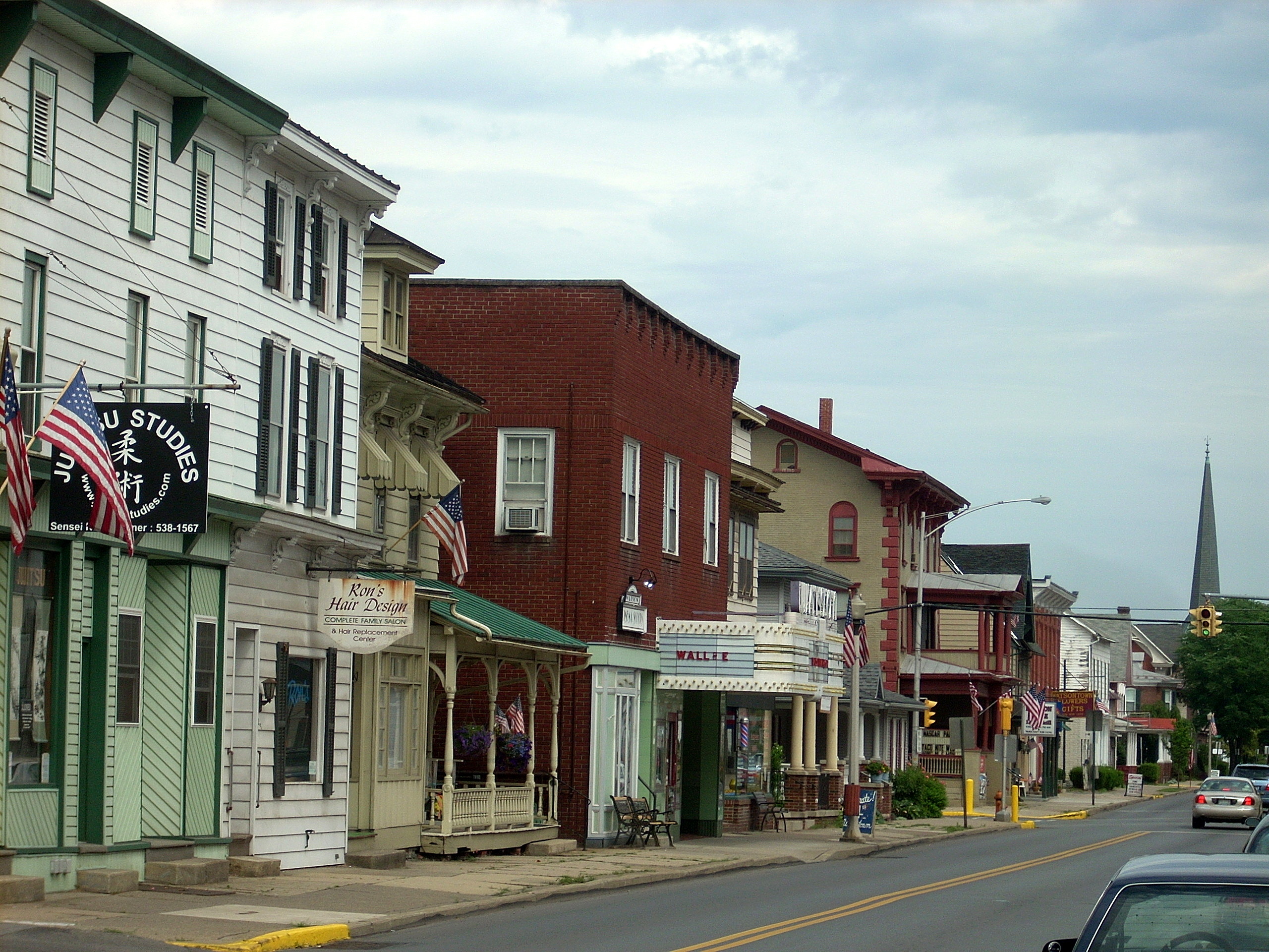
Watsontown is home to The Watsontown Theater. This theater operated in the bourough for nearly 70 years. It opened on May 30, 1940 and closed in September 2009. The theatre is now undergoing maintenance and renovations. Owners of the theater, Shane and Kelly Erb plan to reopen the theatre. However, it will operate as a venue for bands, comedy shows, and conferences.
References
- "ArcGIS REST Services Directory". United States Census Bureau. Retrieved October 15, 2022.
- "Watsontown Topo Map, Northumberland County PA (Milton Area)". TopoZone. Locality, LLC. Retrieved November 28, 2019.
- "Census Population API". United States Census Bureau. Retrieved October 12, 2022.
- "Watsontown Borough, Northumberland County 17777". Retrieved October 18, 2016.
- "US Gazetteer files: 2010, 2000, and 1990". United States Census Bureau. February 12, 2011. Retrieved April 23, 2011.
- "Google Maps". Retrieved October 18, 2016.
- "National Register Information System". National Register of Historic Places. National Park Service. July 9, 2010.
- "Census of Population and Housing". U.S. Census Bureau. Retrieved December 11, 2013.
- "U.S. Census website". United States Census Bureau. Retrieved January 31, 2008.
- "Incorporated Places and Minor Civil Divisions Datasets: Subcounty Resident Population Estimates: April 1, 2010 to July 1, 2012". Population Estimates. U.S. Census Bureau. Retrieved December 11, 2013.
External links
- The Dr. Van Fleet Climbing Rose was created in Watsontown by Dr. Walter Van Fleet, a resident botanist.
- MyWatsontown.com, an online book of Watsontown history
Municipalities and communities of Northumberland County, Pennsylvania, United States | ||
|---|---|---|
County seat: Sunbury | ||
| Cities |  | |
| Boroughs | ||
| Townships | ||
| CDPs | ||
| Unincorporated communities | ||
| ||
Authority control | |
|---|---|
| General |
|
| National libraries | |
На других языках
[de] Watsontown
Watsontown ist ein Borough im Northumberland County im US-Bundesstaat Pennsylvania. Zum Zeitpunkt des United States Census 2000 hatte Watsontown 2254 Einwohner.- [en] Watsontown, Pennsylvania
Другой контент может иметь иную лицензию. Перед использованием материалов сайта WikiSort.org внимательно изучите правила лицензирования конкретных элементов наполнения сайта.
WikiSort.org - проект по пересортировке и дополнению контента Википедии