world.wikisort.org - USA
Valeda is an unincorporated community in Labette County, Kansas, United States.[1]
Valeda, Kansas | |
|---|---|
Unincorporated community | |
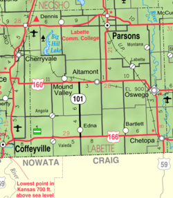 KDOT map of Labette County (legend) | |
 Valeda  Valeda | |
| Coordinates: 37°02′50″N 95°26′51″W[1] | |
| Country | United States |
| State | Kansas |
| County | Labette |
| Founded | 1880s |
| Platted | 1886 |
| Elevation | 860 ft (260 m) |
| Time zone | UTC-6 (CST) |
| • Summer (DST) | UTC-5 (CDT) |
| Area code | 620 |
| FIPS code | 20-72700 [1] |
| GNIS ID | 469169 [1] |
History
Valeda was platted in 1886.[2]
References
- "Valeda, Kansas", Geographic Names Information System, United States Geological Survey
- Blackmar, Frank Wilson (1912). Kansas: A Cyclopedia of State History, Volume 2. Standard Publishing Company. pp. 839.
Further reading
External links
Municipalities and communities of Labette County, Kansas, United States | ||
|---|---|---|
County seat: Oswego | ||
| Cities |  | |
| Unincorporated communities | ||
| Ghost towns |
| |
| Townships |
| |
| Footnotes | †This community is designated a Census-Designated Place (CDP) by the United States Census Bureau. | |
| ||
Текст в блоке "Читать" взят с сайта "Википедия" и доступен по лицензии Creative Commons Attribution-ShareAlike; в отдельных случаях могут действовать дополнительные условия.
Другой контент может иметь иную лицензию. Перед использованием материалов сайта WikiSort.org внимательно изучите правила лицензирования конкретных элементов наполнения сайта.
Другой контент может иметь иную лицензию. Перед использованием материалов сайта WikiSort.org внимательно изучите правила лицензирования конкретных элементов наполнения сайта.
2019-2026
WikiSort.org - проект по пересортировке и дополнению контента Википедии
WikiSort.org - проект по пересортировке и дополнению контента Википедии