world.wikisort.org - USA
Dennis is an unincorporated community in Labette County, Kansas, United States.[1] As of the 2020 census, the population of the community and nearby areas was 152.[2]
Dennis, Kansas | |
|---|---|
Unincorporated community | |
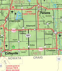 KDOT map of Labette County (legend) | |
 Dennis  Dennis | |
| Coordinates: 37°20′49″N 95°24′46″W[1] | |
| Country | United States |
| State | Kansas |
| County | Labette |
| Founded | 1880s |
| Elevation | 929 ft (283 m) |
| Population (2020)[2] | |
| • Total | 152 |
| Time zone | UTC-6 (CST) |
| • Summer (DST) | UTC-5 (CDT) |
| Area code | 620 |
| FIPS code | 20-17675 [1] |
| GNIS ID | 2804492 [1] |
History
Dennis had its start in the early 1880s by the building of the Memphis, Kansas and Colorado Railroad through that territory.[3] The first post office in Dennis was established in May 1881.[4]
The nearby Big Hill Archeological District is on the National Register of Historic Places.
Demographics
| Historical population | |||
|---|---|---|---|
| Census | Pop. | %± | |
| 2020 | 152 | — | |
| U.S. Decennial Census | |||
For statistical purposes, the United States Census Bureau has defined this community as a census-designated place (CDP).
Education
The community is served by Labette County USD 506 public school district.
See also
References
- "Dennis, Kansas", Geographic Names Information System, United States Geological Survey
- "Profile of Dennis, Kansas (CDP) in 2020". United States Census Bureau. Archived from the original on June 10, 2022. Retrieved June 10, 2022.
- Blackmar, Frank Wilson (1912). Kansas: A Cyclopedia of State History, Embracing Events, Institutions, Industries, Counties, Cities, Towns, Prominent Persons, Etc. Standard Publishing Company. pp. 508.
- "Kansas Post Offices, 1828-1961". Kansas Historical Society. Retrieved 12 June 2014.
Further reading
External links
Municipalities and communities of Labette County, Kansas, United States | ||
|---|---|---|
County seat: Oswego | ||
| Cities |  | |
| Unincorporated communities | ||
| Ghost towns |
| |
| Townships |
| |
| Footnotes | †This community is designated a Census-Designated Place (CDP) by the United States Census Bureau. | |
| ||
Текст в блоке "Читать" взят с сайта "Википедия" и доступен по лицензии Creative Commons Attribution-ShareAlike; в отдельных случаях могут действовать дополнительные условия.
Другой контент может иметь иную лицензию. Перед использованием материалов сайта WikiSort.org внимательно изучите правила лицензирования конкретных элементов наполнения сайта.
Другой контент может иметь иную лицензию. Перед использованием материалов сайта WikiSort.org внимательно изучите правила лицензирования конкретных элементов наполнения сайта.
2019-2026
WikiSort.org - проект по пересортировке и дополнению контента Википедии
WikiSort.org - проект по пересортировке и дополнению контента Википедии