world.wikisort.org - USA
Ship Bottom is a borough in Ocean County, New Jersey, United States. As of the 2010 United States Census, the borough's population was 1,156,[19][20][21] reflecting a decline of 228 (−16.5%) from the 1,384 counted in the 2000 Census, which had in turn increased by 32 (+2.4%) from the 1,352 counted in the 1990 Census.[22] The borough is located on Long Beach Island and borders the Atlantic Ocean. The summer population can be as much as 20,000.[23]
Ship Bottom, New Jersey | |
|---|---|
Borough | |
| Borough of Ship Bottom | |
| Motto: "Gateway to Long Beach Island"[1] | |
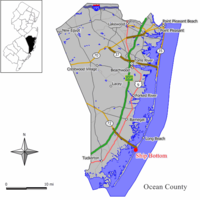 Map of Ship Bottom in Ocean County. Inset: Location of Ocean County highlighted in the State of New Jersey. | |
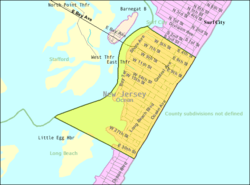 Census Bureau map of Ship Bottom, New Jersey | |
| Coordinates: 39.645354°N 74.183003°W[2][3] | |
| Country | |
| state | |
| County | |
| Incorporated | March 3, 1925 as Ship Bottom-Beach Arlington |
| Renamed | 1947 as Ship Bottom |
| Government | |
| • Type | Borough |
| • Body | Borough Council |
| • Mayor | William Huelsenbeck (R, term ends December 31, 2022)[5][6] |
| • Administrator | Mark A. Pino[7] |
| • Municipal clerk | Kristy Davis[8] |
| Area | |
| • Total | 0.99 sq mi (2.58 km2) |
| • Land | 0.71 sq mi (1.84 km2) |
| • Water | 0.28 sq mi (0.73 km2) 28.48% |
| • Rank | 500th of 565 in state 24th of 33 in county[2] |
| Elevation | 3 ft (0.9 m) |
| Population (2020)[11] | |
| • Total | 1,098 |
| • Rank | 528th of 566 in state 29th of 33 in county[12] |
| • Density | 1,542.13/sq mi (595.28/km2) |
| • Rank | 322nd of 566 in state 16th of 33 in county[12] |
| Time zone | UTC−05:00 (Eastern (EST)) |
| • Summer (DST) | UTC−04:00 (Eastern (EDT)) |
| ZIP Code | |
| Area code(s) | 609 exchanges: 207, 361, 492, 494[15] |
| FIPS code | 3402967110[2][16][17] |
| GNIS feature ID | 0885394[2][18] |
| Website | www |
The borough's name derives from an incident in March 1817, in which a woman was saved from a wrecked ship that had flipped over, after her rescuers used axes to cut through the bottom of the hull.[1][24]
What is now Ship Bottom was originally incorporated as the borough of Ship Bottom-Beach Arlington by an act of the New Jersey Legislature on March 3, 1925, from portions of Long Beach Township, based on the results of a referendum held on May 23, 1925. The borough name was shortened to Ship Bottom in 1947.[25]
The borough is known as the "Gateway to Long Beach Island", as Route 72 provides the sole road access from Manahawkin in Stafford Township, ending in Ship Bottom as it crosses Manahawkin Bay via the Manahawkin Bay Bridge (formally known as the Dorland J. Henderson Memorial Bridge).
Geography
According to the United States Census Bureau, the borough had a total area of 0.99 square miles (2.58 km2), including 0.71 square miles (1.84 km2) of land and 0.28 square miles (0.73 km2) of water (28.48%).[2][3]
Unincorporated communities, localities and place names located partially or completely within the borough include Beach Arlington.[26]
The borough borders the Ocean County municipalities of Long Beach Township, Stafford Township and Surf City.[27][28][29]
Demographics
| Historical population | |||
|---|---|---|---|
| Census | Pop. | %± | |
| 1930 | 277 | — | |
| 1940 | 396 | 43.0% | |
| 1950 | 533 | 34.6% | |
| 1960 | 717 | 34.5% | |
| 1970 | 1,079 | 50.5% | |
| 1980 | 1,427 | 32.3% | |
| 1990 | 1,352 | −5.3% | |
| 2000 | 1,384 | 2.4% | |
| 2010 | 1,156 | −16.5% | |
| 2020 | 1,098 | −5.0% | |
| Population sources: 1930–2000[30] 1930[31] 1930–1990[32] 2000[33][34] 2010[35][19][20][21][11] | |||
Census 2010
The 2010 United States census counted 1,156 people, 555 households, and 329 families in the borough. The population density was 1,620.6 per square mile (625.7/km2). There were 2,066 housing units at an average density of 2,896.3 per square mile (1,118.3/km2). The racial makeup was 92.91% (1,074) White, 1.30% (15) Black or African American, 0.17% (2) Native American, 0.43% (5) Asian, 0.00% (0) Pacific Islander, 3.98% (46) from other races, and 1.21% (14) from two or more races. Hispanic or Latino of any race were 9.17% (106) of the population.[19]
Of the 555 households, 13.7% had children under the age of 18; 46.8% were married couples living together; 7.0% had a female householder with no husband present and 40.7% were non-families. Of all households, 32.8% were made up of individuals and 14.8% had someone living alone who was 65 years of age or older. The average household size was 2.08 and the average family size was 2.60.[19]
12.0% of the population were under the age of 18, 6.9% from 18 to 24, 20.2% from 25 to 44, 32.0% from 45 to 64, and 28.8% who were 65 years of age or older. The median age was 54.2 years. For every 100 females, the population had 104.2 males. For every 100 females ages 18 and older there were 99.4 males.[19]
The Census Bureau's 2006–2010 American Community Survey showed that (in 2010 inflation-adjusted dollars) median household income was $60,673 (with a margin of error of +/− $15,872) and the median family income was $97,841 (+/− $19,072). Males had a median income of $51,641 (+/− $9,381) versus $33,580 (+/− $4,778) for females. The per capita income for the borough was $41,184 (+/− $4,936). About 5.4% of families and 5.2% of the population were below the poverty line, including 6.3% of those under age 18 and 1.9% of those age 65 or over.[36]
Census 2000
As of the 2000 United States Census[16] there were 1,384 people, 664 households, and 395 families residing in the borough. The population density was 1,991.1 inhabitants per square mile (768.8/km2). There were 2,218 housing units at an average density of 3,191.0 per square mile (1,232.1/km2). The racial makeup of the borough was 96.32% White, 0.29% African American, 0.72% Native American, 0.87% Asian, 1.08% from other races, and 0.72% from two or more races. Hispanic or Latino of any race were 5.78% of the population.[33][34]
There were 664 households, out of which 14.3% had children under the age of 18 living with them, 47.3% were married couples living together, 8.0% had a female householder with no husband present, and 40.4% were non-families. 35.8% of all households were made up of individuals, and 17.0% had someone living alone who was 65 years of age or older. The average household size was 2.08 and the average family size was 2.65.[33][34]
In the borough the population was spread out, with 14.8% under the age of 18, 5.9% from 18 to 24, 22.7% from 25 to 44, 29.7% from 45 to 64, and 26.9% who were 65 years of age or older. The median age was 50 years. For every 100 females, there were 92.8 males. For every 100 females age 18 and over, there were 94.2 males.[33][34]
The median income for a household in the borough was $42,098, and the median income for a family was $60,417. Males had a median income of $36,382 versus $28,958 for females. The per capita income for the borough was $27,870. About 4.1% of families and 8.2% of the population were below the poverty line, including 15.0% of those under age 18 and 2.8% of those age 65 or over.[33][34]
Government
Local government
Ship Bottom is governed under the Borough form of New Jersey municipal government, which is used in 218 municipalities (of the 564) statewide, making it the most common form of government in New Jersey.[37] The governing body is comprised of the Mayor and the Borough Council, with all positions elected at-large on a partisan basis as part of the November general election. The Mayor is elected directly by the voters to a four-year term of office. The Borough Council is comprised of six members elected to serve three-year terms on a staggered basis, with two seats coming up for election each year in a three-year cycle.[4] The Borough form of government used by Ship Bottom is a "weak mayor / strong council" government in which council members act as the legislative body with the mayor presiding at meetings and voting only in the event of a tie. The mayor can veto ordinances subject to an override by a two-thirds majority vote of the council. The mayor makes committee and liaison assignments for council members, and most appointments are made by the mayor with the advice and consent of the council.[38][39] Each Council member chairs a committee that oversees a department: Revenue and Finance; Public Safety; Water/Sewer; Parks and Recreation; Public Property and Community Affairs; and Public Works.[40]
As of 2022[update], the Mayor of Ship Bottom Borough is Republican William Huelsenbeck, whose term of office ends on December 31, 2022. Members of the Ship Bottom Borough Council are Council President Edward English (R, 2023), Robert J. Butkus (R, 2022), David Hartman (R, 2023), Peter J. Rossi Sr. (R, 2024), Tom Tallon (R, 2022) and Joseph Valyo (R, 2024).[5][41][42][43][44][45][46][47]
Federal, state and county representation
Ship Bottom is located in the 2nd Congressional District[48] and is part of New Jersey's 9th state legislative district.[20][49][50] Prior to the 2010 Census, Ship Bottom had been part of the 3rd Congressional District, a change made by the New Jersey Redistricting Commission that took effect in January 2013, based on the results of the November 2012 general elections.[51]
For the 117th United States Congress, New Jersey's Second Congressional District is represented by Jeff Van Drew (R, Dennis Township).[52] New Jersey is represented in the United States Senate by Democrats Cory Booker (Newark, term ends 2027)[53] and Bob Menendez (Harrison, term ends 2025).[54][55]
For the 2022–2023 session, the 9th Legislative District of the New Jersey Legislature is represented in the State Senate by Christopher J. Connors (R, Lacey Township) and in the General Assembly by DiAnne Gove (R, Long Beach Township) and Brian E. Rumpf (R, Little Egg Harbor Township).[56]
Ocean County is governed by a Board of County Commissioners comprised of five members who are elected on an at-large basis in partisan elections and serving staggered three-year terms of office, with either one or two seats coming up for election each year as part of the November general election. At an annual reorganization held in the beginning of January, the board chooses a Director and a Deputy Director from among its members.[57] As of 2022[update], Ocean County's Commissioners (with party affiliation, term-end year and residence) are:
Commissioner Director John P. Kelly (R, 2022, Eagleswood Township),[58] Commissioner Deputy Director Virginia E. Haines (R, 2022, Toms River),[59] Barbara Jo Crea (R, 2024, Little Egg Harbor Township)[60] Gary Quinn (R, 2024, Lacey Township)[61] and Joseph H. Vicari (R, 2023, Toms River).[62][63][64] Constitutional officers elected on a countywide basis are County Clerk Scott M. Colabella (R, 2025, Barnegat Light),[65][66] Sheriff Michael G. Mastronardy (R, 2022; Toms River)[67][68] and Surrogate Jeffrey Moran (R, 2023, Beachwood).[69][70][71]
Politics
As of March 23, 2011, there were a total of 988 registered voters in Ship Bottom, of which 142 (14.4%) were registered as Democrats, 497 (50.3%) were registered as Republicans and 349 (35.3%) were registered as Unaffiliated. There were no voters registered to other parties.[72] Among the borough's 2010 Census population, 85.5% (vs. 63.2% in Ocean County) were registered to vote, including 97.1% of those ages 18 and over (vs. 82.6% countywide).[72][73]
In the 2012 presidential election, Republican Mitt Romney received 57.3% of the vote (335 cast), ahead of Democrat Barack Obama with 42.4% (248 votes), and other candidates with 0.3% (2 votes), among the 590 ballots cast by the borough's 998 registered voters (5 ballots were spoiled), for a turnout of 59.1%.[74][75] In the 2008 presidential election, Republican John McCain received 57.2% of the vote (419 cast), ahead of Democrat Barack Obama with 40.3% (295 votes) and other candidates with 1.4% (10 votes), among the 732 ballots cast by the borough's 1,036 registered voters, for a turnout of 70.7%.[76] In the 2004 presidential election, Republican George W. Bush received 57.3% of the vote (449 ballots cast), outpolling Democrat John Kerry with 41.5% (325 votes) and other candidates with 0.6% (7 votes), among the 784 ballots cast by the borough's 1,084 registered voters, for a turnout percentage of 72.3.[77]
In the 2013 gubernatorial election, Republican Chris Christie received 75.3% of the vote (381 cast), ahead of Democrat Barbara Buono with 23.7% (120 votes), and other candidates with 1.0% (5 votes), among the 523 ballots cast by the borough's 967 registered voters (17 ballots were spoiled), for a turnout of 54.1%.[78][79] In the 2009 gubernatorial election, Republican Chris Christie received 63.2% of the vote (349 ballots cast), ahead of Democrat Jon Corzine with 29.2% (161 votes), Independent Chris Daggett with 5.8% (32 votes) and other candidates with 0.9% (5 votes), among the 552 ballots cast by the borough's 1,005 registered voters, yielding a 54.9% turnout.[80]
Education
For pre-kindergarten through sixth grade, public school students attend the Long Beach Island Consolidated School District, which also serves students from Barnegat Light, Harvey Cedars, Long Beach Township and Surf City.[4][81][82] As of the 2020–2021 school year, the district, comprised of two schools, had an enrollment of 215 students and 30.7 classroom teachers (on an FTE basis), for a student–teacher ratio of 7.0:1.[83] Schools in the district (with 2020–2021 enrollment data from the National Center for Education Statistics[84]) are Ethel Jacobsen School[85] in Surf City with 111 students in pre-kindergarten to second grade and Long Beach Island Grade School[86] in Ship Bottom with 125 students in grades 3–6.[87][88][89] The district's board of education is comprised of nine members who are directly elected from the constituent municipalities on a staggered basis, with three members elected each year.[90][91] Of the nine seats, one is elected from ShipBottom.[92]
Students in public school for seventh through twelfth grades attend the Southern Regional School District, which serves the five municipalities in the Long Beach Island Consolidated School District, along with students from Beach Haven and Stafford Township, as well as students from Ocean Township (including its Waretown section) who attend as part of a sending/receiving relationship.[4][93][94] Schools in the district (with 2020–2021 enrollment data from the National Center for Education Statistics[95]) are Southern Regional Middle School[96] with 902 students in grades 7–8 and Southern Regional High School[97] with 1,975 students in grades 9–12.[98][99] Both schools are in the Manahawkin section of Stafford Township.
Transportation

Roads and highways
As of May 2010[update], the borough had a total of 18.57 miles (29.89 km) of roadways, of which 13.32 miles (21.44 km) were maintained by the municipality, 4.65 miles (7.48 km) by Ocean County and 0.60 miles (0.97 km) by the New Jersey Department of Transportation.[100]
The eastern terminus of Route 72 is in Ship Bottom, which connects the borough to the Manahawkin section of Stafford Township via the Manahawkin Bay Bridge (formally known as the Dorland J. Henderson Memorial Bridge).[101]
Public transportation
Ocean Ride local service is provided on the OC9 Long Beach Island route.[102][103][104]
The LBI Shuttle operates along Long Beach Boulevard, providing free service every 5 to 20 minutes from 10:00 AM to 10:00 PM. It serves the Long Beach Island municipalities / communities of Barnegat Light, Loveladies, Harvey Cedars, North Beach, Surf City, Ship Bottom, Long Beach Township, Beach Haven and Holgate.[105]
Climate
According to the Köppen climate classification system, Ship Bottom, New Jersey has a humid subtropical climate (Cfa) with hot, moderately humid summers, cool winters and year-around precipitation. Cfa climates are characterized by all months having an average mean temperature > 32.0 °F (> 0.0 °C), at least four months with an average mean temperature ≥ 50.0 °F (≥ 10.0 °C), at least one month with an average mean temperature ≥ 71.6 °F (≥ 22.0 °C) and no significant precipitation difference between seasons. During the summer months in Ship Bottom, a cooling afternoon sea breeze is present on most days, but episodes of extreme heat and humidity can occur with heat index values ≥ 95 °F (≥ 35 °C). During the winter months, episodes of extreme cold and wind can occur with wind chill values < 0 °F (< −18 °C). The plant hardiness zone at Ship Bottom Beach is 7a with an average annual extreme minimum air temperature of 3.9 °F (−15.6 °C).[106] The average seasonal (November–April) snowfall total is 12 to 18 inches (300 to 460 mm) and the average snowiest month is February, which corresponds with the annual peak in nor'easter activity.
| Climate data for Ship Bottom Beach, NJ (1981–2010 Averages) | |||||||||||||
|---|---|---|---|---|---|---|---|---|---|---|---|---|---|
| Month | Jan | Feb | Mar | Apr | May | Jun | Jul | Aug | Sep | Oct | Nov | Dec | Year |
| Average high °F (°C) | 40.2 (4.6) |
42.4 (5.8) |
49.2 (9.6) |
57.7 (14.3) |
68.0 (20.0) |
77.2 (25.1) |
82.6 (28.1) |
81.4 (27.4) |
75.5 (24.2) |
64.9 (18.3) |
54.9 (12.7) |
45.1 (7.3) |
61.7 (16.5) |
| Daily mean °F (°C) | 33.1 (0.6) |
35.2 (1.8) |
41.6 (5.3) |
50.3 (10.2) |
60.3 (15.7) |
69.6 (20.9) |
75.3 (24.1) |
74.3 (23.5) |
67.9 (19.9) |
56.8 (13.8) |
47.5 (8.6) |
37.9 (3.3) |
54.2 (12.3) |
| Average low °F (°C) | 26.0 (−3.3) |
28.0 (−2.2) |
33.9 (1.1) |
42.9 (6.1) |
52.5 (11.4) |
62.1 (16.7) |
68.1 (20.1) |
67.1 (19.5) |
60.3 (15.7) |
48.7 (9.3) |
40.0 (4.4) |
30.7 (−0.7) |
46.8 (8.2) |
| Average precipitation inches (mm) | 3.33 (85) |
3.01 (76) |
4.09 (104) |
3.58 (91) |
3.07 (78) |
2.96 (75) |
3.93 (100) |
4.22 (107) |
3.07 (78) |
3.52 (89) |
3.12 (79) |
3.54 (90) |
41.44 (1,053) |
| Average relative humidity (%) | 66.9 | 65.0 | 63.2 | 64.5 | 67.3 | 71.6 | 71.1 | 72.5 | 71.6 | 70.2 | 68.9 | 67.8 | 68.4 |
| Average dew point °F (°C) | 23.3 (−4.8) |
24.6 (−4.1) |
30.0 (−1.1) |
38.8 (3.8) |
49.4 (9.7) |
60.0 (15.6) |
65.3 (18.5) |
64.9 (18.3) |
58.4 (14.7) |
47.2 (8.4) |
37.8 (3.2) |
28.2 (−2.1) |
44.1 (6.7) |
| Source: PRISM[107] | |||||||||||||
| Climate data for Atlantic City, NJ Ocean Water Temperature (24 SW Ship Bottom) | |||||||||||||
|---|---|---|---|---|---|---|---|---|---|---|---|---|---|
| Month | Jan | Feb | Mar | Apr | May | Jun | Jul | Aug | Sep | Oct | Nov | Dec | Year |
| Daily mean °F (°C) | 37 (3) |
35 (2) |
42 (6) |
48 (9) |
56 (13) |
63 (17) |
70 (21) |
73 (23) |
70 (21) |
61 (16) |
53 (12) |
44 (7) |
54 (12) |
| Source: NOAA[108] | |||||||||||||
Ecology
According to the A. W. Kuchler U.S. potential natural vegetation types, Ship Bottom, New Jersey would have a dominant vegetation type of Northern Cordgrass (73) with a dominant vegetation form of Coastal Prairie (20).[109]
Notable people
People who were born in, residents of, or otherwise closely associated with Ship Bottom include:
- Wesley Bell (1937–2008), politician who served as Mayor of Stafford Township, New Jersey[110]
- Matt Cook (born 1984), actor known mostly for his roles as Mo McCracken on the TBS sitcom Clipped and as Lowell in the CBS sitcom Man with a Plan[111]
- Zack Hanle (c. 1915–1999), was a cooking author and journalist who served as an editor of Bon Appetit, in addition to writing books about cooking, diet and exercise[112]
- Matt Kmosko (born 1972), former U.S. soccer defender who played three and a half seasons in Major League Soccer[113]
- Stanley B. Smullen (1906–1998), businessman who served briefly on the Philadelphia City Council[114]
References
- History of Ship Bottom, Borough of Ship Bottom. Accessed August 31, 2020. "Ship Bottom is one of the oldest place names on Long Beach Island. According to the local historian John Bailey Lloyd, author of "Six Miles at Sea," the name dates from an unusual shipwreck that occurred in March, 1817.... With an ax, Willets chopped a hole in the ship's bottom near the keel and, after much struggling, freed the young woman trapped inside.... But the place of the shipwreck and the rescue became known as 'Ship Bottom'."
- 2019 Census Gazetteer Files: New Jersey Places, United States Census Bureau. Accessed July 1, 2020.
- US Gazetteer files: 2010, 2000, and 1990, United States Census Bureau. Accessed September 4, 2014.
- 2012 New Jersey Legislative District Data Book, Rutgers University Edward J. Bloustein School of Planning and Public Policy, March 2013, p. 49.
- Mayor and Council, Borough of Ship Bottom. Accessed May 25, 2022.
- 2022 New Jersey Mayors Directory, New Jersey Department of Community Affairs. Accessed March 1, 2022.
- Borough Administrator, Borough of Ship Bottom. Accessed May 25, 2022.
- Municipal Clerk's Office, Borough of Ship Bottom. Accessed May 25, 2022.
- "ArcGIS REST Services Directory". United States Census Bureau. Retrieved October 11, 2022.
- U.S. Geological Survey Geographic Names Information System: Borough of Ship Bottom, Geographic Names Information System. Accessed March 14, 2013.
- "Census Population API". United States Census Bureau. Retrieved October 11, 2022.
- GCT-PH1 Population, Housing Units, Area, and Density: 2010 - State -- County Subdivision from the 2010 Census Summary File 1 for New Jersey [dead link], United States Census Bureau. Accessed January 1, 2013.
- Look Up a ZIP Code for Ship Bottom, NJ, United States Postal Service. Accessed January 1, 2013.
- Zip Codes, State of New Jersey. Accessed August 30, 2013.
- Area Code Lookup - NPA NXX for Ship Bottom, NJ, Area-Codes.com. Accessed January 30, 2017.
- U.S. Census website , United States Census Bureau. Accessed September 4, 2014.
- Geographic Codes Lookup for New Jersey, Missouri Census Data Center. Accessed April 1, 2022.
- US Board on Geographic Names, United States Geological Survey. Accessed September 4, 2014.
- DP-1 - Profile of General Population and Housing Characteristics: 2010 for Ship Bottom borough, Ocean County, New Jersey Archived February 12, 2020, at archive.today, United States Census Bureau. Accessed January 1, 2013.
- Municipalities Sorted by 2011-2020 Legislative District, New Jersey Department of State. Accessed February 1, 2020.
- Profile of General Demographic Characteristics: 2010 for Ship Bottom borough Archived March 4, 2016, at the Wayback Machine, New Jersey Department of Labor and Workforce Development. Accessed January 1, 2013.
- Table 7. Population for the Counties and Municipalities in New Jersey: 1990, 2000 and 2010, New Jersey Department of Labor and Workforce Development, February 2011. Accessed January 1, 2013.
- Facts, Borough of Ship Bottom. Accessed May 25, 2022. "Summer Population: Approximately 20,000"
- Hutchinson, Viola L. The Origin of New Jersey Place Names, New Jersey Public Library Commission, May 1945. Accessed October 3, 2015.
- Snyder, John P. The Story of New Jersey's Civil Boundaries: 1606-1968, Bureau of Geology and Topography; Trenton, New Jersey; 1969. p. 205. Accessed October 23, 2012.
- Locality Search, State of New Jersey. Accessed May 21, 2015.
- Areas touching Ship Bottom, MapIt. Accessed March 6, 2020.
- Ocean County Map, Coalition for a Healthy NJ. Accessed March 6, 2020.
- New Jersey Municipal Boundaries, New Jersey Department of Transportation. Accessed November 15, 2019.
- Barnett, Bob. Population Data for Ocean County Municipalities, 1850 - 2000, WestJersey.org, January 6, 2011. Accessed January 1, 2013.
- Fifteenth Census of the United States : 1930 - Population Volume I, United States Census Bureau, p. 718. Accessed July 9, 2012. Listed as Barnegat City.
- Table 6. New Jersey Resident Population by Municipality: 1930 - 1990 Archived March 19, 2018, at the Wayback Machine, New Jersey Department of Labor and Workforce Development. Accessed June 28, 2015.
- Census 2000 Profiles of Demographic / Social / Economic / Housing Characteristics for Ship Bottom borough, New Jersey[permanent dead link], United States Census Bureau. Accessed January 1, 2013.
- DP-1: Profile of General Demographic Characteristics: 2000 - Census 2000 Summary File 1 (SF 1) 100-Percent Data for Ship Bottom borough, Ocean County, New Jersey Archived February 12, 2020, at archive.today, United States Census Bureau. Accessed January 1, 2013.
- "DataUniverse - 2010 Census Populations - Ocean County", Asbury Park Press. Accessed January 1, 2013.
- DP03: Selected Economic Characteristics from the 2006-2010 American Community Survey 5-Year Estimates for Ship Bottom borough, Ocean County, New Jersey Archived February 12, 2020, at archive.today, United States Census Bureau. Accessed January 1, 2013.
- Inventory of Municipal Forms of Government in New Jersey, Rutgers University Center for Government Studies, July 1, 2011. Accessed November 18, 2019.
- Cerra, Michael F. "Forms of Government: Everything You've Always Wanted to Know, But Were Afraid to Ask" Archived 2014-09-24 at the Wayback Machine, New Jersey State League of Municipalities. Accessed November 30, 2014.
- "Forms of Municipal Government in New Jersey", p. 6. Rutgers University Center for Government Studies. Accessed June 3, 2015.
- Main page, Borough of Ship Bottom. Accessed July 12, 2006.
- 2022 Municipal Data Sheet, Borough of Ship Bottom. Accessed May 25, 2022.
- Borough of Ship Bottom, Ocean County, New Jersey. Accessed May 25, 2022.
- 2022 Ocean County & Municipal Elected Officials, Ocean County, New Jersey Clerk, updated April 1, 2022. Accessed May 1, 2022.
- 2021 General Election Official Results, Ocean County, New Jersey. Accessed January 1, 2022.
- 2020 General Election November 3, 2020 Official results, Ocean County, New Jersey, updated December 2, 2020. Accessed January 1, 2021.
- 2019 General Election Official Results November 5, 2019, Ocean County, New Jersey Clerk, updated November 15, 2019. Accessed January 1, 2020.
- 2018 General Election Official Results November 6, 2018, Ocean County, New Jersey Clerk, updated November 19, 2018. Accessed January 1, 2019.
- Plan Components Report, New Jersey Redistricting Commission, December 23, 2011. Accessed February 1, 2020.
- 2019 New Jersey Citizen's Guide to Government, New Jersey League of Women Voters. Accessed October 30, 2019.
- Districts by Number for 2011-2020, New Jersey Legislature. Accessed January 6, 2013.
- 2011 New Jersey Citizen's Guide to Government Archived June 4, 2013, at the Wayback Machine, p. 64, New Jersey League of Women Voters. Accessed May 22, 2015.
- Directory of Representatives: New Jersey, United States House of Representatives. Accessed January 3, 2019.
- U.S. Sen. Cory Booker cruises past Republican challenger Rik Mehta in New Jersey, PhillyVoice. Accessed April 30, 2021. "He now owns a home and lives in Newark's Central Ward community."
- Biography of Bob Menendez, United States Senate, January 26, 2015. "Menendez, who started his political career in Union City, moved in September from Paramus to one of Harrison's new apartment buildings near the town's PATH station.."
- Home, sweet home: Bob Menendez back in Hudson County. nj.com. Accessed April 30, 2021. "Booker, Cory A. - (D - NJ) Class II; Menendez, Robert - (D - NJ) Class I"
- Legislative Roster for District 9, New Jersey Legislature. Accessed January 11, 2022.
- Freeholder to Commissioner History, Ocean County, New Jersey. Accessed June 1, 2022.
- Commissioner John P. Kelly, Ocean County, New Jersey. Accessed June 1, 2022.
- Commissioner Director Virginia E. Haines, Ocean County, New Jersey. Accessed June 1, 2022.
- Commissioner Barbara Jo Crea, Ocean County, New Jersey. Accessed June 1, 2022.
- Commissioner Gary Quinn, Ocean County, New Jersey. Accessed June 1, 2022.
- Commissioner Joseph H. Vicari, Ocean County, New Jersey. Accessed June 1, 2022.
- Meet our Commissioners, Ocean County, New Jersey. Accessed June 1, 2022.
- County Directory, Ocean County, New Jersey. Accessed June 1, 2022.
- County Clerk, Ocean County, New Jersey. Accessed June 1, 2022.
- Clerks, Constitutional Officers Association of New Jersey. Accessed June 1, 2022.
- County Sheriff Michael G. Mastronardy, Ocean County, New Jersey. Accessed June 1, 2022.
- Sheriffs, Constitutional Officers Association of New Jersey. Accessed June 1, 2022.
- County Surrogate Jeffrey W. Moran, Ocean County, New Jersey. Accessed June 1, 2022.
- Surrogates, Constitutional Officers Association of New Jersey. Accessed June 1, 2022.
- 2022 Ocean County and Municipal Elected Officials, Ocean County, New Jersey. Accessed June 1, 2022.
- Voter Registration Summary - Ocean, New Jersey Department of State Division of Elections, March 23, 2011. Accessed January 1, 2013.
- GCT-P7: Selected Age Groups: 2010 - State -- County Subdivision; 2010 Census Summary File 1 for New Jersey Archived February 12, 2020, at archive.today, United States Census Bureau. Accessed January 1, 2013.
- "Presidential General Election Results - November 6, 2012 - Ocean County" (PDF). New Jersey Department of Elections. March 15, 2013. Retrieved December 24, 2014.
- "Number of Registered Voters and Ballots Cast - November 6, 2012 - General Election Results - Ocean County" (PDF). New Jersey Department of Elections. March 15, 2013. Retrieved December 24, 2014.
- 2008 Presidential General Election Results: Ocean County, New Jersey Department of State Division of Elections, December 23, 2008. Accessed January 1, 2013.
- 2004 Presidential Election: Ocean County, New Jersey Department of State Division of Elections, December 13, 2004. Accessed January 1, 2013.
- "Governor - Ocean County" (PDF). New Jersey Department of Elections. January 29, 2014. Retrieved December 24, 2014.
- "Number of Registered Voters and Ballots Cast - November 5, 2013 - General Election Results - Ocean County" (PDF). New Jersey Department of Elections. January 29, 2014. Retrieved December 24, 2014.
- 2009 Governor: Ocean County Archived October 17, 2012, at the Wayback Machine, New Jersey Department of State Division of Elections, December 31, 2009. Accessed January 1, 2013.
- LAN Associates. Study of School Consolidation Long Beach Island, New Jersey Archived 2013-09-27 at the Wayback Machine, Long Beach Island Consolidated School District, January 21, 2011. Accessed September 25, 2013. "The Long Beach Island Consolidated School District serves the needs of the citizens of Long Beach Island including the communities of Barnegat Light Borough, Long Beach Township, Harvey Cedars Borough, Surf City Borough, and Ship Bottom Borough. The remaining community of Beach Haven at the south end of the island currently has its own school. The Long Beach Island Consolidated Schools serve children from the age of pre-school through sixth grade after which the students attend Southern Regional High School in Manahawkin."
- Long Beach Island Board of Education District Policy 0110 - Identification, Long Beach Island Consolidated School District. Accessed July 4, 2022. "Purpose The Board of Education exists for the purpose of providing a thorough and efficient system of free public education in grades Pre-Kindergarten through six in the Long Beach Island School District. Composition The Long Beach Island School District is comprised of all the area within the municipal boundaries of Barnegat Light, Harvey Cedars, Long Beach Township, Ship Bottom, and Surf City."
- District information for Long Beach Island Consolidated School District, National Center for Education Statistics. Accessed February 15, 2022.
- School Data for the Long Beach Island School District, National Center for Education Statistics. Accessed November 1, 2019.
- Ethel Jacobsen School, Long Beach Island Consolidated School District. Accessed July 4, 2022.
- Long Beach Island Grade School, Long Beach Island Consolidated School District. Accessed July 4, 2022.
- Public Schools Directory 2020–2022, Ocean County, New Jersey. Accessed July 1, 2022.
- School Performance Reports for the Long Beach Island Consolidated School District, New Jersey Department of Education. Accessed July 4, 2022.
- New Jersey School Directory for the Long Beach Island Consolidated School District, New Jersey Department of Education. Accessed December 29, 2016.
- New Jersey Boards of Education by District Election Types - 2018 School Election, New Jersey Department of Education, updated February 16, 2018. Accessed January 26, 2020.
- Comprehensive Annual Financial Report for the Long Beach Island Consolidated School District, New Jersey Department of Education, June 30, 2021. Accessed July 4, 2022. "The School District is a Type II district located in the County of Ocean, State of New Jersey. As a Type II district, the School District functions independently through a Board of Education. The Board is comprised of nine members appointed to three-year terms. These terms are staggered so that three members' terms expire each year. The District provides a full range of educational services appropriate to grades levels kindergarten through 6th grade."
- "Four on Ballot for LBI School Board", The SandPaper, October 23, 2019. Accessed July 4, 2022. "The LBI school board is comprised of nine members, four from Long Beach Township, two from Surf City, and one each from Ship Bottom, Harvey Cedars and Barnegat Light."
- Southern Regional High School 2015 Report Card Narrative, New Jersey Department of Education. Accessed June 2, 2016. "Located in Manahawkin, the Southern Regional School District draws from the constituent districts of Long Beach Township, Beach Haven, Surf City, Ship Bottom, Barnegat Light, Harvey Cedars and Stafford Township, as well as the tuition sending district of Ocean Township (Waretown).
- About Us, Southern Regional School District. Accessed July 4, 2022. "Our school is a 7-12 comprehensive regional high school district. Our middle school covers grades 7-8 and our high school covers grades 9-12. The district is comprised of the constituent members of Stafford Township, Beach Haven, Long Beach Township, (which includes the municipalities [sic] of Loveladies, North Beach, High Bar Harbor and Brant Beach and Long Beach Township) Barnegat Light, Harvey Cedars, Ship Bottom, and Surf City. Waretown is our sending district."
- School Data for the Southern Regional School District, National Center for Education Statistics. Accessed February 15, 2022.
- Southern Regional Middle School, Southern Regional School District. Accessed July 4, 2022.
- Southern Regional High School, Southern Regional School District. Accessed July 4, 2022.
- School Performance Reports for the Southern Regional School District, New Jersey Department of Education. Accessed July 4, 2022.
- New Jersey School Directory for the Southern Regional School District, New Jersey Department of Education. Accessed December 29, 2016.
- Ocean County Mileage by Municipality and Jurisdiction, New Jersey Department of Transportation, May 2010. Accessed November 5, 2013.
- Route 72 Straight Line Diagram, New Jersey Department of Transportation, February 2009. Accessed November 5, 2013.
- Ocean County Bus Service Archived August 14, 2015, at the Wayback Machine, Greater Mercer TMA. Accessed August 12, 2015.
- Ocean Ride Rider's Guide Archived June 27, 2015, at the Wayback Machine, Ocean County, New Jersey. Accessed August 12, 2015.
- Ocean County Transit Guide Archived September 23, 2015, at the Wayback Machine, Ocean County, New Jersey. Accessed August 12, 2015.
- LBI Shuttle, Borough of Barnegat Light. Accessed August 9, 2015.
- "USDA Interactive Plant Hardiness Map". United States Department of Agriculture. Archived from the original on July 4, 2019. Retrieved August 5, 2019.
- Time Series Values for Individual Locations, PRISM Climate Group Oregon State University. Accessed March 18, 2020.
- Water Temperature Table of All Coastal Regions, National Oceanic and Atmospheric Administration. Accessed March 18, 2020.
- U.S. Potential Natural Vegetation, Original Kuchler Types, v2.0 (Spatially Adjusted to Correct Geometric Distortions), Data Basin. Accessed March 18, 2020.
- Mongelli, Tom. "Late Stafford Mayor's Wife Settles Debt, Moves On", WOBM-FM, June 10, 2009. Accessed December 20, 2016. "Bell, a Philadelphia native, was three when his family moved to Ship Bottom in 1940. He became a Stafford elected official in 1969."
- Staff. "Island Native Matt Cook Stars in Sitcom ‘Clipped’ Premiering Tuesday on TBS ", TheSandPaper.net, June 9, 2015. Accessed October 9, 2017. "Matt Cook, Island boy and Southern Regional High School alumnus, formerly of Barnegat Light and Ship Bottom, has landed a starring role in the new half-hour, multi-camera, live-studio-audience show by Max Mutchnick and David Kohan, the creators of Will and Grace."
- Grimes, William. "Dorothea Zack Hanle, 83, Editor And Writer About Fine Cooking", The New York Times, February 18, 1999. Accessed October 10, 2017. "Dorothea Zack Hanle, a longtime editor at Bon Appetit, a cookbook writer and one of the founders of Les Dames d'Escoffier, an international women's organization that promotes fine dining and wine, died Tuesday at the home of her son, Alan, in North Brunswick, N.J. She was 83 and lived in Manhattan and Ship Bottom, N.J."
- Matt Kmosko, Columbus Crew. Accessed August 14, 2007.
- Staff. "Obituary: Stanley B. Smullen Jr.", Asbury Park Press, July 11, 1998. Accessed October 9, 2017. "Stanley B. Smullen Jr., 91, of Ship Bottom, died Thursday at home. He was a self-employed real estate broker for many years in the Philadelphia area and also was a Republican Ward Leader and served on the Philadelphia City Council, retiring in 1971.... Born in Philadelphia, he lived there before moving to Ship Bottom in 1971, where he had been a summer resident for many years."
External links
- Ship Bottom Borough website
- Long Beach Island School District
- School Performance Reports for the Long Beach Island School District, New Jersey Department of Education
- School Data for the Long Beach Island School District, National Center for Education Statistics
- Southern Regional School District
- Ship Bottom Volunteer Fire Company Station 46

Authority control | |
|---|---|
| General |
|
| National libraries | |
Другой контент может иметь иную лицензию. Перед использованием материалов сайта WikiSort.org внимательно изучите правила лицензирования конкретных элементов наполнения сайта.
WikiSort.org - проект по пересортировке и дополнению контента Википедии