world.wikisort.org - USA
San Manuel is a census-designated place (CDP) in Pinal County, Arizona, United States. The population was 3,551 at the 2010 census.
San Manuel, Arizona | |
|---|---|
CDP | |
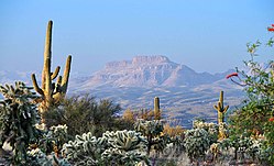
 A view from Redington Rd SE of San Manuel with Galiuro Mountains in background. | |
| Motto: "A Proud Past – An Epic Future" | |
 Location in Pinal County and the state of Arizona | |
 San Manuel, Arizona Location in the United States | |
| Coordinates: 32°36′18″N 110°38′0″W | |
| Country | United States |
| State | Arizona |
| County | Pinal |
| Area | |
| • Total | 20.75 sq mi (53.75 km2) |
| • Land | 20.75 sq mi (53.75 km2) |
| • Water | 0.00 sq mi (0.00 km2) |
| Elevation | 3,451 ft (1,052 m) |
| Population (2020) | |
| • Total | 3,114 |
| • Density | 150.04/sq mi (57.93/km2) |
| Time zone | UTC-7 (MST (no DST)) |
| ZIP code | 85631 |
| Area code | 520 |
| FIPS code | 04-63540 |
| GNIS feature ID | 34022 |
San Manuel was built in 1953 by Del E. Webb Construction Company as a company town to serve the then-new San Manuel copper mine, mill and smelter complex. In 1955 the San Manuel Arizona Railroad was built to connect with the Copper Basin Railway at Hayden.[2] When copper prices fell in the late 1990s, BHP, the owner of the mine and smelter complex shuttered both operations in June 1999. The closing saw 2,500 people lose their jobs. The mine and smelter were permanently closed in 2003.
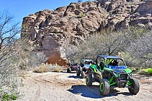
The community is on the edge of the Sonoran Desert with its saguaros and overlooks the San Pedro River valley and panoramic Galiuro Mountains. Today, San Manuel is a leisure destination popular for hunting, sightseeing, and is a hub for off-road adventure for dirt bikes, UTV's and ATV's. UTV rentals and guided tours are available in town. Several museums include a mining museum and a motorcycle museum. It is also a gateway city of The Arizona Trail.[3][4][5] Nearby towns are Oracle and Mammoth. Both are within 10 mi (16 km) of San Manuel and make up a tri-community area.
Geography
San Manuel is located at 32°36′18″N 110°38′0″W (32.605048, -110.633340),[6] in the San Pedro River Valley at an elevation of about 3,500 feet (1,100 m). San Manuel is approximately 45 miles (72 km) northeast of Tucson.
According to the United States Census Bureau, the CDP has a total area of 20.9 sq mi (54 km2) all land.
Airport
San Manuel Airport – E77 known as San Manuel Ray Blair Airport is public and located 2 mi (3.2 km) NW of San Manuel, Arizona. It has one paved runway of 4,207 ft × 75 ft (1,282 m × 23 m) with lights and a paved taxiway.[7]
Local & area attractions
- JWJ Cycles, motorcycle museum
- San Manuel Museum, developed and operated by the San Manuel Historical Society. Mining history.
- Arizona Trail, located just west of San Manuel
- Peppersauce Cave, primitive cave
Events
- San Manuel Copper Classic, annual off-road motorcycle race in March hosted by The Trail Riders of Southern Arizona
- Copper Town Days, annual event in San Manuel the second Saturday in October with a car show, food and entertainment
- San Manuel Chili Cook-Off, music, games, vendors and taste testing
- Santa Catalina Weekend, bicycle races
Demographics
| Historical population | |||
|---|---|---|---|
| Census | Pop. | %± | |
| 1960 | 4,524 | — | |
| 1970 | 4,332 | −4.2% | |
| 1980 | 5,443 | 25.6% | |
| 1990 | 4,009 | −26.3% | |
| 2000 | 4,375 | 9.1% | |
| 2010 | 3,551 | −18.8% | |
| 2020 | 3,114 | −12.3% | |
| U.S. Decennial Census[8][9] | |||
As of the census[10] of 2000, there were 4,375 people, 1,458 households, and 1,204 families residing in the CDP. The population density was 209.5 inhabitants per square mile (80.9/km2). There were 1,832 housing units at an average density of 87.7 per square mile (33.9/km2). The racial makeup of the CDP was 69.1% White, 0.4% Black or African American, 1.4% Native American, 0.3% Asian, 0.1% Pacific Islander, 24.8% from other races, and 4.0% from two or more races. 46.2% of the population were Hispanic or Latino of any race.
There were 1,458 households, out of which 43.1% had children under the age of 18 living with them, 66.3% were married couples living together, 10.6% had a female householder with no husband present, and 17.4% were non-families. 15.0% of all households were made up of individuals, and 6.7% had someone living alone who was 65 years of age or older. The average household size was 3.00 and the average family size was 3.31.
In the CDP, the population was spread out, with 32.6% under the age of 18, 8.8% from 18 to 24, 27.0% from 25 to 44, 21.1% from 45 to 64, and 10.5% who were 65 years of age or older. The median age was 32 years. For every 100 females, there were 102.5 males. For every 100 females age 18 and over, there were 98.1 males.
The median income for a household in the CDP was $40,019, and the median income for a family was $42,563. Males had a median income of $36,463 versus $21,304 for females. The per capita income for the CDP was $16,534. About 10.3% of families and 12.8% of the population were below the poverty line, including 18.4% of those under age 18 and 5.6% of those age 65 or over.


References
- "2020 U.S. Gazetteer Files". United States Census Bureau. Retrieved October 29, 2021.
- "A history of the San Manuel Arizona Railroad 'SMARRCO'". Retrieved 30 October 2021.
- "San Manuel, Arizona – Official Guide". Retrieved 28 December 2017.
- "Off-Road Adventure – San Manuel, Arizona". Retrieved 25 November 2020.
- "The Arizona Trail Gateway Communities". Retrieved 28 December 2017.
- "US Gazetteer files: 2010, 2000, and 1990". United States Census Bureau. 2011-02-12. Retrieved 2011-04-23.
- "AirNav, LLC". Retrieved 28 December 2017.
- "Number of Inhabitants Arizona" (PDF). Census.gov. Retrieved Jan 5, 2018.
- "1990 Census of Population General Population Characteristics Arizona" (PDF). Census.gov. Retrieved Jan 5, 2018.
- "U.S. Census website". United States Census Bureau. Retrieved 2008-01-31.
External links
- San Manuel, Arizona – Tourism Guide
- Peppersauce Motorsports & Rentals – UTV Rentals & Tours
- JWJ Cycles - Motorcycle Museum
- Annual Chili Cook-off
На других языках
- [en] San Manuel, Arizona
[es] San Manuel (Arizona)
San Manuel es un lugar designado por el censo (en inglés, census-designated place, CDP) ubicado en el condado de Pinal, Arizona, Estados Unidos. Según el censo de 2020, tiene una población de 3114 habitantes.[3][it] San Manuel (Arizona)
San Manuel è un census-designated place (CDP) degli Stati Uniti d'America, situato nello stato dell'Arizona, nella contea di Pinal.Другой контент может иметь иную лицензию. Перед использованием материалов сайта WikiSort.org внимательно изучите правила лицензирования конкретных элементов наполнения сайта.
WikiSort.org - проект по пересортировке и дополнению контента Википедии
