world.wikisort.org - USA
Polebridge is an unincorporated community in Flathead County, Montana, United States,[2] 35 miles (56 km) northwest of Columbia Falls in the northwestern part of the state. This community was named in 1920 for the log bridge that formerly connected the "inner" North Fork Road in Glacier National Park to the "outer" North Fork Road which leads to Montana Secondary Highway 486, over the North Fork Flathead River.[3] Polebridge lies near the Canada–United States border.
Polebridge, Montana | |
|---|---|
Census-Designated Place | |
 Polebridge | |
| Country | United States |
| State | Montana |
| County | Flathead |
| Area | |
| • Total | 0.12 sq mi (0.31 km2) |
| • Land | 0.12 sq mi (0.30 km2) |
| • Water | 0.00 sq mi (0.00 km2) |
| Population (2020) | |
| • Total | 14 |
| • Density | 119.66/sq mi (46.25/km2) |
| FIPS code | 30-58675 |
| GNIS feature ID | 789068[2] |
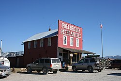
The W.L. Adair General Mercantile Historic District is a National Register of Historic Places-listed historic district in Polebridge. It contains the Polebridge Mercantile, which has been in operation since 1914.[4] The store is open from May through October.[5]
Residents do not have electrical service. From May through October, the population is just under 100, but during the colder months it falls to the single digits.[5]
Demographics
| Historical population | |||
|---|---|---|---|
| Census | Pop. | %± | |
| 2020 | 14 | — | |
| U.S. Decennial Census[6] | |||
See also
- Glacier View Dam, proposed in the 1940s, which would have inundated Polebridge
References
- "ArcGIS REST Services Directory". United States Census Bureau. Retrieved September 18, 2022.
- U.S. Geological Survey Geographic Names Information System: Polebridge, Montana
- "Polebridge". Montana Place Names Companion. Montana Historical Society. Retrieved 8 April 2021.
- Gildart, Robert (1986). Montana's Flathead Country. Montana Magazine. p. 74. ISBN 0-938314-14-9.
- Randall, Brianna (16 February 2021). "Welcome to Poleridge: One of the US′ last frontiers". bbc.com. BBC. Retrieved 2021-02-26.
- "Census of Population and Housing". Census.gov. Retrieved June 4, 2016.
Другой контент может иметь иную лицензию. Перед использованием материалов сайта WikiSort.org внимательно изучите правила лицензирования конкретных элементов наполнения сайта.
WikiSort.org - проект по пересортировке и дополнению контента Википедии
