world.wikisort.org - USA
North Little Rock is a city in Pulaski County, Arkansas, across the Arkansas from Little Rock in the central part of the state. The population was 64,591 at the 2020 census. In 2019 the estimated population was 65,903,[3] making it the seventh-most populous city in the state. North Little Rock, along with Little Rock and Conway, anchors the six-county Little Rock–North Little Rock–Conway Metropolitan Statistical Area (2014 population 729,135), which is further included in the Little Rock-North Little Rock Combined Statistical Area with 902,443 residents.
North Little Rock, Arkansas | |
|---|---|
| City of North Little Rock, Arkansas | |
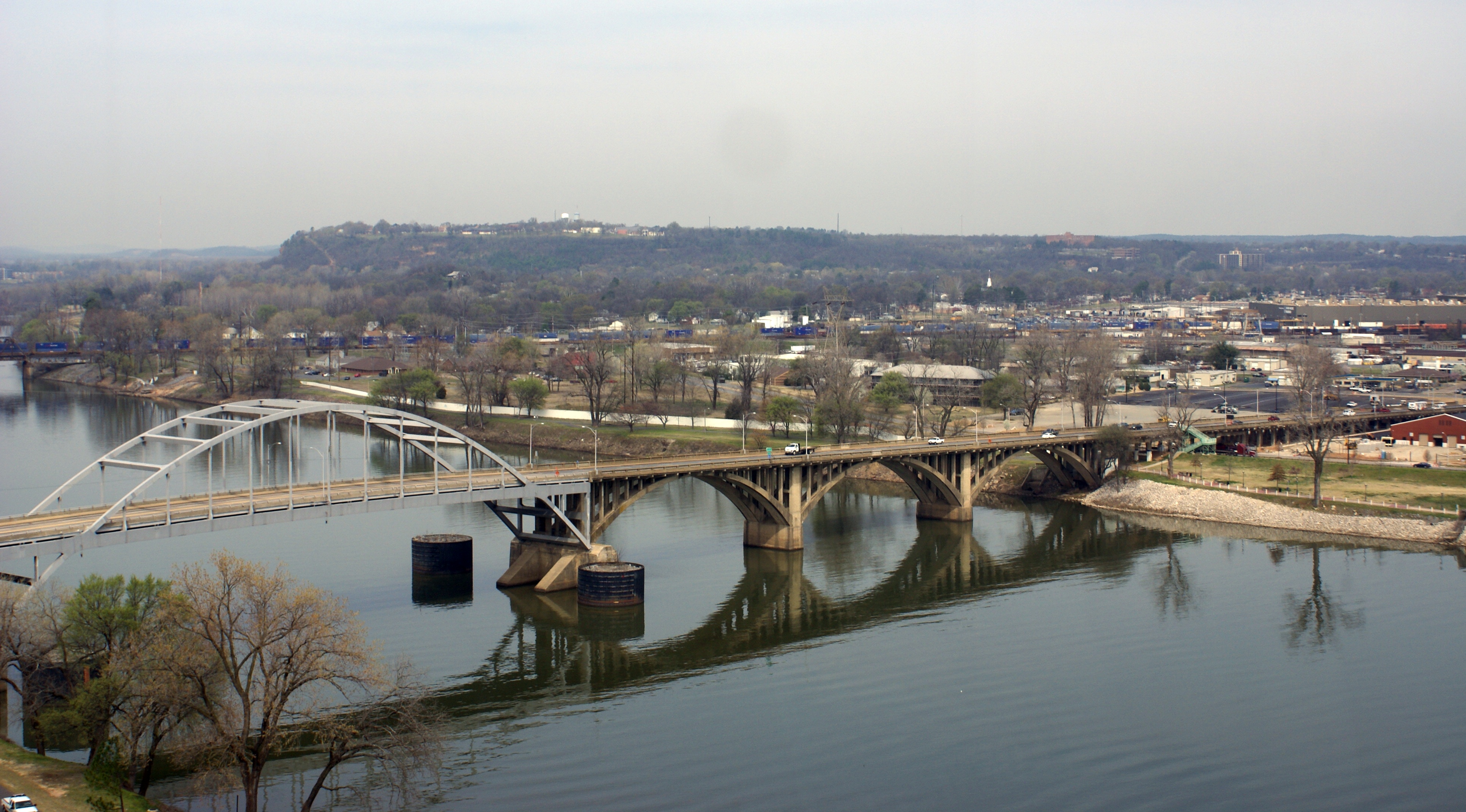 View of North Little Rock from across the Arkansas | |
 Location of North Little Rock in Pulaski County, Arkansas | |
 North Little Rock Location in the Arkansas | |
| Coordinates: 34°46′51″N 92°15′25″W | |
| Country | |
| State | |
| County | Pulaski |
| Township | Hill |
| Founded | April 18, 1871 |
| Incorporated | July 17, 1901 |
| Named for | Little Rock, Arkansas |
| Government | |
| • Type | Mayor–Council |
| • Mayor | Terry Hartwick |
| • Council | North Little Rock City Council |
| Area | |
| • City | 56.20 sq mi (145.55 km2) |
| • Land | 53.04 sq mi (137.38 km2) |
| • Water | 3.15 sq mi (8.16 km2) |
| Elevation | 266 ft (81 m) |
| Population (2020) | |
| • City | 64,591 |
| • Rank | US: 524th |
| • Density | 1,217.69/sq mi (470.15/km2) |
| • Urban | 431,388 (US: 88th) |
| • Metro | 729,135 (US: 75th) |
| Time zone | UTC−6 (CST) |
| • Summer (DST) | UTC−5 (CDT) |
| ZIP codes | 72114-119, 721124, 72190, 72199 |
| Area code | 501 |
| FIPS code | 05-50450 |
| GNIS feature ID | 0077862[2] |
| Website | www |
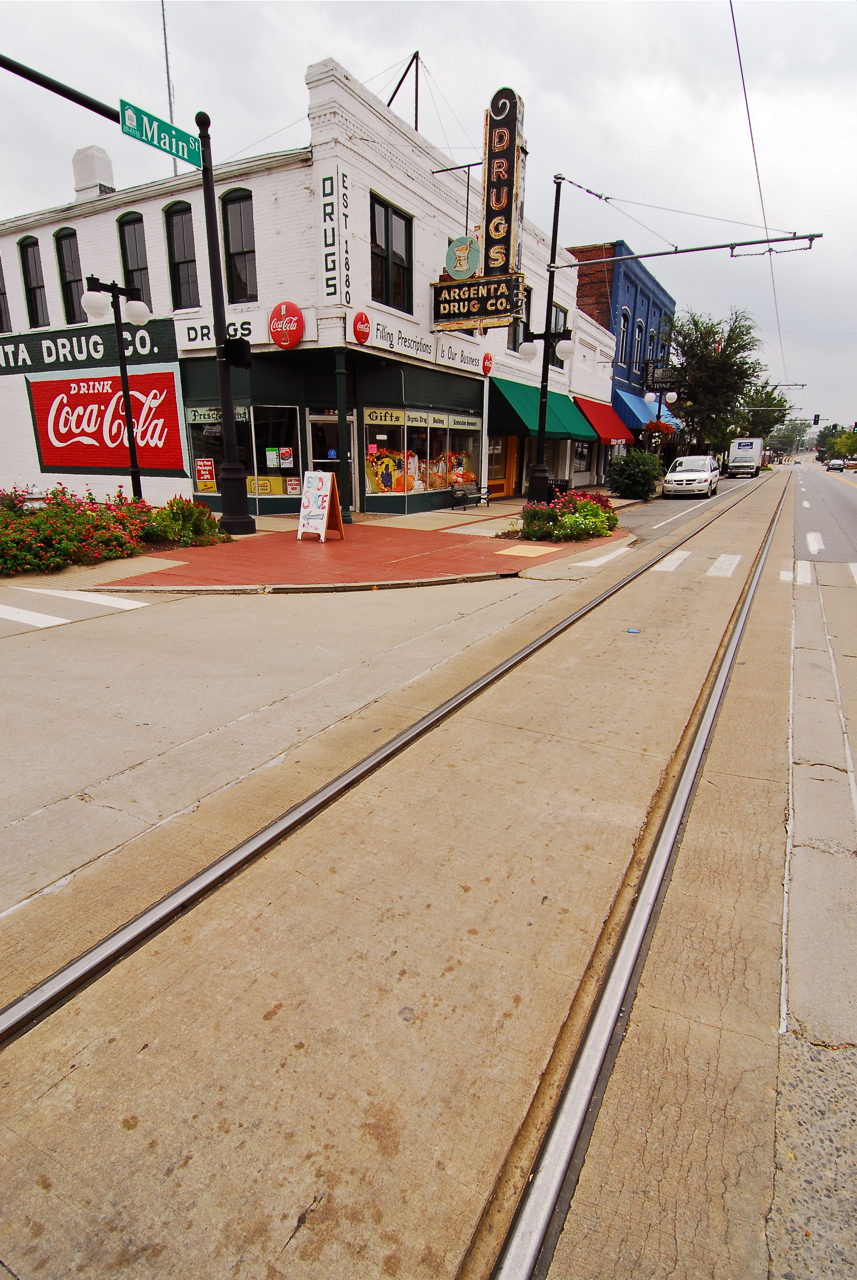
The city's downtown is anchored in the Argenta Historic District, the location of Dickey-Stephens Park, home of the Arkansas Travelers minor league baseball team, and Simmons Bank Arena, the metropolitan area's main entertainment venue. Farther west is Burns Park, one of the largest municipal parks in the United States.
History
Originally named Argenta, Arkansas, it was founded on April 18, 1871.[4] In 1890, the city of Little Rock annexed Argenta as part of its eighth ward, preempting a competing petition to incorporate. As part of a plan to reclaim its independence, Argenta was incorporated on July 17, 1901, as the town of "North Little Rock". By 1904, the state's supreme court allowed North Little Rock to annex what was left of the ward. It readopted the name Argenta in 1906, only to revert to North Little Rock in October 1917. Evidence of the old town can still be found in the North Little Rock City Hall (built in 1914) which contains plaques referring to Argenta, and incorporates "C of A" (i.e. City of Argenta) ornamental features.[5]
Geography
According to the United States Census Bureau, the city has a total area of 47.0 square miles (122 km2), of which 44.8 square miles (116 km2) is land and 2.2 square miles (5.7 km2) (4.58%) is water.
Neighborhoods
- Amboy
- Argenta Historic District
- Arrowhead Manor
- Chimney Rock
- Crystal Hill
- Dark Hollow
- Indian Hills
- Lakewood
- Levy
- Mid-City
- Overbrook
- Park Hill
- Pike View
- Rose City
- Windsor Valley
Climate
The climate in this area is characterized by hot, humid summers and generally mild to cool winters. According to the Köppen Climate Classification system, North Little Rock has a humid subtropical climate, abbreviated "Cfa" on climate maps.[6]
North Little Rock has a humid subtropical climate with long, hot, and sunny summers and mild, wet winters with little snow. January on average is the coldest month, while July is typically the warmest, though occasionally August can claim the distinction.[7] The overall yearly average temperature is 62.5 degrees. Precipitation averages 45.79 inches a year, with winter and spring tending to be wetter than summer and autumn.[8] Severe thunderstorms can occur, especially during the Spring, on April 25, 2011, a possible tornado struck the air force base in the city.
| Climate data for Little Rock (Little Rock Nat'l Airport), 1991−2020 normals,[lower-alpha 1] extremes 1875−present[lower-alpha 2] | |||||||||||||
|---|---|---|---|---|---|---|---|---|---|---|---|---|---|
| Month | Jan | Feb | Mar | Apr | May | Jun | Jul | Aug | Sep | Oct | Nov | Dec | Year |
| Record high °F (°C) | 83 (28) |
87 (31) |
91 (33) |
95 (35) |
98 (37) |
107 (42) |
112 (44) |
114 (46) |
106 (41) |
98 (37) |
86 (30) |
81 (27) |
114 (46) |
| Mean maximum °F (°C) | 72 (22) |
76 (24) |
82 (28) |
86 (30) |
91 (33) |
96 (36) |
100 (38) |
101 (38) |
96 (36) |
89 (32) |
80 (27) |
73 (23) |
102 (39) |
| Average high °F (°C) | 50.5 (10.3) |
55.2 (12.9) |
63.7 (17.6) |
72.8 (22.7) |
80.5 (26.9) |
88.2 (31.2) |
91.7 (33.2) |
91.5 (33.1) |
85.1 (29.5) |
74.2 (23.4) |
61.9 (16.6) |
52.6 (11.4) |
72.3 (22.4) |
| Daily mean °F (°C) | 40.7 (4.8) |
44.7 (7.1) |
52.7 (11.5) |
61.4 (16.3) |
69.9 (21.1) |
78.0 (25.6) |
81.4 (27.4) |
80.8 (27.1) |
74.0 (23.3) |
62.6 (17.0) |
51.1 (10.6) |
43.0 (6.1) |
61.7 (16.5) |
| Average low °F (°C) | 30.9 (−0.6) |
34.2 (1.2) |
41.8 (5.4) |
50.1 (10.1) |
59.3 (15.2) |
67.7 (19.8) |
71.2 (21.8) |
70.1 (21.2) |
62.9 (17.2) |
50.9 (10.5) |
40.2 (4.6) |
33.3 (0.7) |
51.0 (10.6) |
| Mean minimum °F (°C) | 16 (−9) |
21 (−6) |
27 (−3) |
37 (3) |
47 (8) |
60 (16) |
66 (19) |
64 (18) |
50 (10) |
37 (3) |
26 (−3) |
20 (−7) |
14 (−10) |
| Record low °F (°C) | −8 (−22) |
−12 (−24) |
11 (−12) |
28 (−2) |
38 (3) |
46 (8) |
54 (12) |
52 (11) |
37 (3) |
27 (−3) |
10 (−12) |
−1 (−18) |
−12 (−24) |
| Average precipitation inches (mm) | 3.50 (89) |
3.97 (101) |
4.96 (126) |
5.59 (142) |
5.08 (129) |
3.55 (90) |
3.33 (85) |
3.16 (80) |
3.01 (76) |
4.47 (114) |
4.72 (120) |
5.08 (129) |
50.42 (1,281) |
| Average snowfall inches (cm) | 1.1 (2.8) |
1.6 (4.1) |
0.5 (1.3) |
0.0 (0.0) |
0.0 (0.0) |
0.0 (0.0) |
0.0 (0.0) |
0.0 (0.0) |
0.0 (0.0) |
0.0 (0.0) |
0.0 (0.0) |
0.6 (1.5) |
3.8 (9.7) |
| Average precipitation days (≥ 0.01 in) | 9.2 | 9.3 | 10.5 | 9.4 | 10.9 | 8.0 | 8.7 | 7.2 | 6.6 | 8.1 | 8.5 | 9.5 | 105.9 |
| Average snowy days (≥ 0.1 in) | 0.5 | 0.9 | 0.4 | 0.0 | 0.0 | 0.0 | 0.0 | 0.0 | 0.0 | 0.0 | 0.1 | 0.3 | 2.2 |
| Mean monthly sunshine hours | 180.9 | 188.2 | 244.5 | 276.7 | 325.3 | 346.2 | 351.0 | 323.0 | 271.9 | 251.0 | 176.9 | 166.2 | 3,101.8 |
| Percent possible sunshine | 58 | 62 | 66 | 71 | 75 | 80 | 80 | 78 | 73 | 72 | 57 | 54 | 70 |
| Source: NOAA (sun 1961−1990 at North Little Rock Airport)[9][10][11][12] | |||||||||||||
Demographics
| Historical population | |||
|---|---|---|---|
| Census | Pop. | %± | |
| 1910 | 11,138 | — | |
| 1920 | 14,048 | 26.1% | |
| 1930 | 19,418 | 38.2% | |
| 1940 | 21,137 | 8.9% | |
| 1950 | 44,097 | 108.6% | |
| 1960 | 58,032 | 31.6% | |
| 1970 | 60,040 | 3.5% | |
| 1980 | 64,388 | 7.2% | |
| 1990 | 61,741 | −4.1% | |
| 2000 | 60,433 | −2.1% | |
| 2010 | 62,304 | 3.1% | |
| 2020 | 64,591 | 3.7% | |
| U.S. Decennial Census[13] | |||
2020 census
| Race | Num. | Perc. |
|---|---|---|
| White | 28,430 | 44.02% |
| Black or African American | 27,465 | 42.52% |
| Native American | 222 | 0.34% |
| Asian | 726 | 1.12% |
| Pacific Islander | 30 | 0.05% |
| Other/Mixed | 3,126 | 4.84% |
| Hispanic or Latino | 4,592 | 7.11% |
As of the 2020 United States Census, there were 64,591 people, 27,903 households, and 14,720 families residing in the city.
2010 census
As of the census of 2010, there were 62,304 people, 25,542 households, and 16,117 families residing in the city. The population density was 1,348.6 inhabitants per square mile (520.7/km2). There were 27,567 housing units at an average density of 615.2 per square mile (237.5/km2). The city was 54.02% White, 39.73% Black or African American, 0.41% Native American, 0.94% Asian, 0.07% Pacific Islander, 2.71% from other races, and 2.14% from two or more races. 5.71% of the population were Hispanic or Latino of any race.
There were 25,542 households, out of which 28.9% had children under the age of 18 living with them, 41.9% were married couples living together, 17.6% had a female householder with no husband present, and 36.9% were non-families. 32.0% of all households were made up of individuals, and 12.2% had someone living alone who was 65 years of age or older. The average household size was 2.35 and the average family size was 2.97.
In the city, the population was spread out, with 25.5% under the age of 18, 9.0% from 18 to 24, 28.4% from 25 to 44, 22.5% from 45 to 64, and 14.6% who were 65 years of age or older[citation needed]. The median age was 36 years. For every 100 females, there were 87.7 males. For every 100 females age 18 and over, there were 82.9 males[citation needed].
The median income for a household in the city was $35,578, and the median income for a family was $43,595[citation needed]. Males had a median income of $31,420 versus $24,987 for females[citation needed]. The per capita income for the city was $19,662[citation needed]. About 12.4% of families and 16.1% of the population were below the poverty line, including 26.5% of those under age 18 and 11.7% of those age 65 or over[citation needed].
Arts and culture
Points of interest

- Argenta Historic District
- Argenta Plaza [15]
- Arkansas National Guard Museum
- Burns Park
- Simmons Bank Arena with the Arkansas Sports Hall of Fame Museum
- McCain Mall
- Lakewood Village [16]
- Arkansas Inland Maritime Museum, and the Navy tug Hoga (YT-146), a survivor of the attack on Pearl Harbor, and the USS Razorback (SS-394), which was at the surrender in Tokyo Bay
Sports
Dickey-Stephens Park is the location of the Arkansas Travelers baseball team.
Parks and recreation
- Arkansas River Trail
- Big Rock Quarry Park, which includes a Bike Park and Pump Track
- Burns Park, one of the largest city-owned parks in the United States, contains a baseball and softball complex, soccer complex, campground, two golf courses, hiking trails, amusement park, and tennis complex.
- Campbell Lake Park
- Conley Park
- Crestview Park
- Emerald Park
- Fearneyhough Park
- Idlewild Park
- North Little Rock Riverfront Park (formally known as North Shore Riverwalk Park)
- Riverview Park, includes a skate park with street elements and a bowl
- T. R. Pugh Memorial Park, location of the Old Mill in the movie Gone With The Wind
- Vestal Park
- W.C. Faucette Memorial Park
- Witkowski Park
Government
The City of North Little Rock elected officials are a mayor, city council of city council members (eight total, with two from each of the four wards), city clerk/treasurer, city attorney, and two judges. This is supplemented by a number of boards and commissions composed of city officials and residents.[17]
Intergovernmental Relations
North Little Rock is home to the headquarters of the Arkansas Municipal League (AML), the state's only municipal representation organization. AML prides itself on providing leadership to each city or town before the state and federal governments. It is also a place for discussion and sharing of mutual concerns.[18]
Education
Public primary and secondary schools
Most students attend public schools in the North Little Rock School District[citation needed] which includes:
- One high school
- North Little Rock High School grades 9-12
- One middle school
- North Little Rock Middle School, which is subdivided into a 6th grade campus and a 7-8th grade campus
- Nine elementary schools
- Amboy Elementary
- Boone Park Elementary
- Crestwood Elementary
- Glenview Elementary
- Indian Hills Elementary
- Lakewood Elementary
- Meadow Park Elementary
- Ridge Road Elementary (formerly Ridge Road Middle School)
- Seventh Street Elementary
- One early childhood center
- Pike View Early Childhood Center
The North Little Rock High School West Campus facility is listed on the National Register of Historic Places for its art-deco architecture style.[citation needed]
In addition, the Pulaski County Special School District administers several other North Little Rock area schools, including:
- one middle school, and
- three elementary schools and one elementary magnet school.
Scipio Jones High School, the segregated public school for black children, was established in 1909 and disestablished in 1970.[19]
Private primary and secondary schools
In North Little Rock there are a number of private schools:
- Calvary Academy (PreK3-12)
- Central Arkansas Christian Schools (PreK3-12)
- Immaculate Conception (K-8)
- North Little Rock Montessori
- North Little Rock Catholic Academy (PreK3-8)
- Formed in 2007 by the merger of St. Mary School and St. Patrick School.[20]
North Little Rock previously had a Catholic grade school for black people, St. Augustine School. It closed in 1976.[21]
Post-secondary education
- University of Arkansas – Pulaski Technical College
- Shorter College (Arkansas)
- Arkansas College of Barbering and Hair Design
- New Tyler Barber College
- Diesel Driving Academy
- Lee's School of Cosmetology
- The Salon Professional Academy
- National Real Estate School
- U.S. Dept of Veterans Affairs Police Law Enforcement Training Center
Public libraries
The North Little Rock Public Library System has two branches: the Argenta Branch Library and the William F. Laman branch, which was named after a former mayor.[22]
Infrastructure
Transportation
Highways
North Little Rock is also the eastern terminus of Interstate 30 and southern terminus of the Arkansas-designated portion of Interstate 57. Interstate 40, US 65, US 67, and US 167 all run through the city.
Bus
North Little Rock is home to the headquarters of Rock Region Metro, Arkansas's largest transit agency. Before 2015, it was known as CATA (Central Arkansas Transit Authority). That same year, all of CATA's former buses were retrofitted to be energy-efficient. Rock Region's main bus terminal is located in Little Rock nearby the city's River Market. Rock Region also has the Metro Rail streetcars, which are a group of classic black and yellow streetcars that can be seen in Little Rock’s River Market and North Little Rock’s Argenta.
Air
In the city's northern part is the North Little Rock Municipal Airport. It has several hangars and is frequented by people who fly biplanes. It is a reliever airport for Clinton National Airport. It is also home to the National Weather Service North Little Rock, Arkansas. This is a major weather service authority in the region and frequently works with major media platforms to inform Arkansans of weather patterns in the state.
Police
| North Little Rock | |
|---|---|
| Crime rates* (2012) | |
| Violent crimes | |
| Homicide | 8 |
| Rape | 9 |
| Robbery | 177 |
| Aggravated assault | 255 |
| Total violent crime | 449 |
| Property crimes | |
| Burglary | 1,204 |
| Larceny-theft | 3,894 |
| Motor vehicle theft | 373 |
| Arson | 10 |
| Total property crime | 5,471 |
Notes *Number of reported crimes per 100,000 population. 2012 population: 63,125 Source: 2012 FBI UCR Data | |
The North Little Rock Police Department operates unmanned aerial vehicles and has been working with a small pilotless helicopter since 2008.[23]
Fire department
In addition to fire and EMS calls, the North Little Rock Fire Department (NLRFD) responds to calls for their Special Operations Response Team, Haz Mat Response Team, and Water Rescue for the Arkansas River.[24]
Hospitals
- Baptist Health Medical Center - North Little Rock
- Eugene J. Towbin Healthcare Center
- Arkansas Surgical Hospital
Notable residents
- Joey Lauren Adams, actress and director
- Ben M. Bogard, American Baptist Association founder, clergyman in North Little Rock from 1903 to 1909[25]
- Maxine Brown, country singer (of The Browns fame)
- John Burkhalter, businessman and politician
- A. J. Burnett, former Major League Baseball (MLB) pitcher
- Maurice Clemmons, perpetrator of 2009 Lakewood shooting
- Donnie Copeland, Pentecostal pastor and member of the Arkansas House of Representatives for District 38
- Jeremy Davis, bassist for pop-punk band Paramore
- Pat Hays, former mayor of North Little Rock
- Cliff Hoofman, Justice on the Arkansas Supreme Court
- Jerry Jones, owner of the Dallas Cowboys
- Glenn Myatt, Major League Baseball catcher
- Darren McFadden, Dallas Cowboys running back
- Tommy Norman, North Little Rock Police Officer, known for positive community policing
- Frank Page, radio broadcaster, attended school in North Little Rock
- Charles Robinson, Arkansas State Treasurer
- Mary Steenburgen, actress
- Jason White, guitarist for Green Day
- Pharoah Sanders, jazz saxophonist
Sister cities
Notes
- Mean monthly maxima and minima (i.e. the expected highest and lowest temperature readings at any point during the year or given month) calculated based on data at said location from 1991 to 2020.
- Official records for Little Rock began on 28 February 1875 at the State Capitol and maintained there until 30 April 1942. The next day, and until 7 August 1942, temperature and precipitation were recorded separately at two different locations in and around Little Rock, and the official climatology station has been Adams Field since 8 August 1942. For more information, see Threadex
References
- "2020 U.S. Gazetteer Files". United States Census Bureau. Retrieved October 29, 2021.
- "US Board on Geographic Names". United States Geological Survey. October 25, 2007. Retrieved January 31, 2008.
- "Population and Housing Unit Estimates". Retrieved May 21, 2020.
- Record of Appointment of Postmasters, 1832-1971. NARA Microfilm Publication, M841, 145 rolls. Records of the Post Office Department, Record Group Number 28, Washington, D.C.: National Archives
- Adams, Walter M., "A History of North Little Rock The Unique City" (1986, August House)(ISBN 0874830028)
- Climate Summary for North Little Rock
- "North Little Rock, AR Weather Forecast and Conditions - The Weather Channel | Weather.com". The Weather Channel. Retrieved August 19, 2017.
- Data, US Climate. "Climate North Little Rock - Arkansas and Weather averages North Little Rock". www.usclimatedata.com. Retrieved August 19, 2017.
- "NowData - NOAA Online Weather Data". National Oceanic and Atmospheric Administration. Retrieved June 18, 2021.
- "Station: Little Rock AP Adams FLD, AR". U.S. Climate Normals 2020: U.S. Monthly Climate Normals (1991-2020). National Oceanic and Atmospheric Administration. Retrieved June 18, 2021.
- "Climatological Averages, Statistics and Records for Little Rock, Arkansas" (PDF). National Weather Service. Retrieved June 18, 2021.
- "WMO 1961–1990 Climate Normals for North Little Rock Airport". National Oceanic and Atmospheric Administration. Retrieved June 18, 2021.
- "Census of Population and Housing". Census.gov. Retrieved June 4, 2015.
- "Explore Census Data". data.census.gov. Retrieved December 9, 2021.
- "Argenta Plaza". Retrieved April 15, 2022.
- "Lakewood Village". Retrieved April 15, 2022.
- "About Government". City of North Little Rock. Archived from the original on 28 May 2017. Retrieved 17 June 2017.
- "Mission Statement". Arkansas Municipal League. Retrieved April 15, 2022.
- Hanley, Steven G. and Ray Hanley. Around Little Rock: A Postcard History. Arcadia Publishing, June 1, 1998. ISBN 0738568678, 9780738568676. p. 118.
- Hargett, Malea (March 28, 2013). "Despite 'year of grace,' St. Joseph School will close". Arkansas Catholic. Retrieved July 31, 2017.
- Hargett, Malea (May 12, 2012). "State's last black Catholic school to close". Arkansas Catholic. Retrieved July 31, 2017.
- "About Us". Laman Library. Retrieved April 11, 2022.
- Pasztor, Andy (April 21, 2012). "Drone Use Takes Off on the Home Front - WSJ.com". Online.wsj.com. Retrieved July 10, 2013.
- "About Fire Department". City of North Little Rock. Archived from the original on 1 December 2017. Retrieved 17 June 2017.
- "Benjamin Marcus Bogard (1868–1951)". encyclopediaofarkansas.net. Retrieved August 2, 2013.
- "Sister cities". North Little Rock. Intrado Corporation. Retrieved September 14, 2022.
External links
 Media from Commons
 Travel information from Wikivoyage
- Official website

 Geographic data related to North Little Rock, Arkansas at OpenStreetMap
 - North Little Rock, Arkansas at Ballotpedia
- North Little Rock, Arkansas at Curlie
- North Little Rock Chamber of Commerce
- North Little Rock Welcome Center
- Works by or about North Little Rock, Arkansas at Internet Archive
Municipalities and communities of Pulaski County, Arkansas, United States | ||
|---|---|---|
County seat: Little Rock | ||
| Cities |  | |
| CDPs | ||
| Other unincorporated communities | ||
| Footnotes | ‡This populated place also has portions in an adjacent county or counties | |
| ||
Authority control | |
|---|---|
| General | |
| National libraries | |
| Other |
|
На других языках
[de] North Little Rock
North Little Rock ist eine Stadt im Pulaski County im US-Bundesstaat Arkansas in den Vereinigten Staaten, mit 62.304 Einwohnern (Stand: 2010). Das Stadtgebiet hat eine Größe von 121,6 km².- [en] North Little Rock, Arkansas
[ru] Норт-Литл-Рок
Норт-Литл-Рок (англ. North Little Rock) — город с местным самоуправлением в штате Арканзас, США. Население — 62 304 человека (по переписи 2010 года). Расположен на реке Арканзас, напротив столицы штата Литл-Рок.Другой контент может иметь иную лицензию. Перед использованием материалов сайта WikiSort.org внимательно изучите правила лицензирования конкретных элементов наполнения сайта.
WikiSort.org - проект по пересортировке и дополнению контента Википедии