world.wikisort.org - USA
Muscle Ridge Islands is an archipelago and unorganized territory off the coast of South Thomaston in Knox County, Maine, United States.[1] The population was 9 at the 2020 census.[2]
Muscle Ridge Islands, Maine | |
|---|---|
Unorganized territory | |
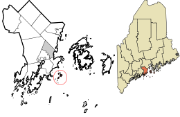 Location in Knox County and the state of Maine. | |
| Coordinates: 44°2′31″N 69°2′19″W | |
| Country | United States |
| State | Maine |
| County | Knox |
| Area | |
| • Total | 49.7 sq mi (128.6 km2) |
| • Land | 0.95 sq mi (2.45 km2) |
| • Water | 48.7 sq mi (126.2 km2) |
| Population (2020) | |
| • Total | 9 |
| Time zone | UTC-5 (Eastern (EST)) |
| • Summer (DST) | UTC-4 (EDT) |
| Area code | 207 |
| FIPS code | 23-47962 |
| GNIS feature ID | 1934678 |
Geography
According to the United States Census Bureau, the unorganized territory has a total area of 49.7 square miles (128.6 km2), of which 0.95 square miles (2.45 km2) is land and 48.7 square miles (126.2 km2) is water (98%).[3] The archipelago includes over a dozen islands, including Andrews, Dix, Fisherman, Pleasant, Graffam, and Two Bush Island, which is home to the Two Bush Island Light.[4]
References
- U.S. Geological Survey Geographic Names Information System: Muscle Ridge Islands, Maine
- "Census - Geography Profile: Muscle Ridge Islands UT, Knox County, Maine". United States Census Bureau. Retrieved March 19, 2022.
- "U.S. Gazetteer Files 2019". United States Census Bureau. Retrieved July 13, 2020.
- "Muscle Ridge Shoals Township". Maine: An Encyclopedia. Retrieved July 13, 2020.
Municipalities and communities of Knox County, Maine, United States | ||
|---|---|---|
County seat: Rockland | ||
| City |  | |
| Towns | ||
| Plantation | ||
| Unorganized territories | ||
| CDPs | ||
| Other villages |
| |
| ||
Текст в блоке "Читать" взят с сайта "Википедия" и доступен по лицензии Creative Commons Attribution-ShareAlike; в отдельных случаях могут действовать дополнительные условия.
Другой контент может иметь иную лицензию. Перед использованием материалов сайта WikiSort.org внимательно изучите правила лицензирования конкретных элементов наполнения сайта.
Другой контент может иметь иную лицензию. Перед использованием материалов сайта WikiSort.org внимательно изучите правила лицензирования конкретных элементов наполнения сайта.
2019-2026
WikiSort.org - проект по пересортировке и дополнению контента Википедии
WikiSort.org - проект по пересортировке и дополнению контента Википедии