world.wikisort.org - USA
Messer is an unincorporated community located on State Highway 93 in Choctaw County, Oklahoma, United States.[1][2]
Messer, Oklahoma | |
|---|---|
Unincorporated community | |
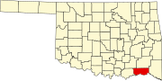
 Messer Location within the state of Oklahoma  Messer Messer (the United States) | |
| Coordinates: 34°05′14″N 95°28′10″W | |
| Country | United States |
| State | Oklahoma |
| County | Choctaw |
| Time zone | UTC-6 (Central (CST)) |
| • Summer (DST) | UTC-5 (CDT) |
| GNIS feature ID | 1100629 |
A post office was established at Messer, Indian Territory on January 4, 1907. It closed on February 29, 1916.[3] At the time of its founding, Messer was located in Kiamitia County, a part of the Apukshunnubbee District of the Choctaw Nation.[4]
References
- Official State Highway Map (Map) (2005-2006 ed.). Oklahoma Department of Transportation. § O7.
- U.S. Geological Survey Geographic Names Information System: Messer, Oklahoma
- Shirk, George H. Oklahoma Place Names (Norman: University of Oklahoma, 1965), p. 139.
- Morris, John W. Historical Atlas of Oklahoma (Norman: University of Oklahoma, 1986), plate 38.
Municipalities and communities of Choctaw County, Oklahoma, United States | ||
|---|---|---|
County seat: Hugo | ||
| City |
|  |
| Towns | ||
| CDPs |
| |
| Other unincorporated communities | ||
| Indian reservation |
| |
| Footnotes | ‡This populated place also has portions in another county or counties | |
| ||
This Oklahoma state location article is a stub. You can help Wikipedia by expanding it. |
Текст в блоке "Читать" взят с сайта "Википедия" и доступен по лицензии Creative Commons Attribution-ShareAlike; в отдельных случаях могут действовать дополнительные условия.
Другой контент может иметь иную лицензию. Перед использованием материалов сайта WikiSort.org внимательно изучите правила лицензирования конкретных элементов наполнения сайта.
Другой контент может иметь иную лицензию. Перед использованием материалов сайта WikiSort.org внимательно изучите правила лицензирования конкретных элементов наполнения сайта.
2019-2026
WikiSort.org - проект по пересортировке и дополнению контента Википедии
WikiSort.org - проект по пересортировке и дополнению контента Википедии