world.wikisort.org - USA
McDade is an unincorporated community in Montgomery County, Alabama, United States. McDade is located near the intersection of Alabama State Route 293 and Alabama State Route 110, 16.9 miles (27.2 km) east of Montgomery. The community was settled in the 1810s and named for a prominent local family. Revolutionary War veteran James McDade is buried in the McDade family cemetery (Manning Springs) [2]
McDade, Alabama | |
|---|---|
Unincorporated community | |
 McDade  McDade | |
| Coordinates: 32°18′57″N 86°02′47″W | |
| Country | United States |
| State | Alabama |
| County | Montgomery |
| Elevation | 249 ft (76 m) |
| Time zone | UTC-6 (Central (CST)) |
| • Summer (DST) | UTC-5 (CDT) |
| Area code | 334 |
| GNIS feature ID | 156683[1] |
References
- "McDade". Geographic Names Information System. United States Geological Survey, United States Department of the Interior.
- Foscue, Virginia (1989). Place Names in Alabama. Tuscaloosa: The University of Alabama Press. p. 88. ISBN 0-8173-0410-X.
Municipalities and communities of Montgomery County, Alabama, United States | ||
|---|---|---|
County seat: Montgomery | ||
| Cities | 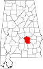 | |
| Towns | ||
| Unincorporated communities | ||
| Indian reservation |
| |
| Footnotes | ‡This populated place also has portions in an adjacent county or counties | |
| ||
This Montgomery County, Alabama state location article is a stub. You can help Wikipedia by expanding it. |
Текст в блоке "Читать" взят с сайта "Википедия" и доступен по лицензии Creative Commons Attribution-ShareAlike; в отдельных случаях могут действовать дополнительные условия.
Другой контент может иметь иную лицензию. Перед использованием материалов сайта WikiSort.org внимательно изучите правила лицензирования конкретных элементов наполнения сайта.
Другой контент может иметь иную лицензию. Перед использованием материалов сайта WikiSort.org внимательно изучите правила лицензирования конкретных элементов наполнения сайта.
2019-2026
WikiSort.org - проект по пересортировке и дополнению контента Википедии
WikiSort.org - проект по пересортировке и дополнению контента Википедии