world.wikisort.org - USA
Manville is a borough in Somerset County, New Jersey, United States. The borough is located in the heart of the Raritan Valley region and is a part of the New York metropolitan area. As of the 2010 United States Census, the borough's population was 10,344,[18][19][20] reflecting an increase of one person (+0.0%) from the 10,343 counted in the 2000 Census, which had in turn declined by 224 (−2.1%) from the 10,567 counted in the 1990 Census.[21] Manville was named after the Johns-Manville Corporation, which maintained a large manufacturing facility in the borough for decades.
Manville, New Jersey | |
|---|---|
Borough | |
| Borough of Manville | |
 Central business district of Manville | |
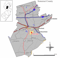 Map of Manville in Somerset County. Inset: Location of Somerset County highlighted in the State of New Jersey. | |
 Census Bureau map of Manville, New Jersey | |
| Coordinates: 40.541269°N 74.589273°W[1][2] | |
| Country | |
| State | |
| County | |
| Incorporated | April 18, 1929 |
| Government | |
| • Type | Borough |
| • Body | Borough Council |
| • Mayor | Richard Onderko (R, term ends December 31, 2023)[4][5] |
| • Administrator | Gian-Paolo Caminiti[6] |
| • Municipal clerk | Wendy Barras[7] |
| Area | |
| • Total | 2.45 sq mi (6.34 km2) |
| • Land | 2.36 sq mi (6.11 km2) |
| • Water | 0.09 sq mi (0.23 km2) 3.59% |
| • Rank | 377th of 565 in state 15th of 21 in county[1] |
| Elevation | 56 ft (17 m) |
| Population (2020)[10] | |
| • Total | 10,953 |
| • Rank | 237th of 566 in state 11th of 21 in county[11] |
| • Density | 4,639.14/sq mi (1,791.26/km2) |
| • Rank | 134th of 566 in state 5th of 21 in county[11] |
| Time zone | UTC−05:00 (Eastern (EST)) |
| • Summer (DST) | UTC−04:00 (Eastern (EDT)) |
| ZIP Code | |
| Area code | 908[14] |
| FIPS code | 3403543620[1][15][16] |
| GNIS feature ID | 0885291[1][17] |
| Website | www |
Historically, many of Manville's residents are of Slavic—mostly eastern Polish (23.1% of the borough's population in 2000[22]) and western Ukrainian descent—with many businesses and restaurants geared towards the Polish-American community located along Main Street (County Route 533).
Manville was formed by an act of the New Jersey Legislature on April 1, 1929, subject to the results of a referendum held on April 18, 1929.[23]
Geography
According to the United States Census Bureau, the borough had a total area of 2.45 square miles (6.34 km2), including 2.36 square miles (6.11 km2) of land and 0.09 square miles (0.23 km2) of water (3.59%).[1][2]
Unincorporated communities, localities and place names located partially or completely within the borough include Millsboro.[24]
The borough borders Bridgewater Township, Franklin Township and Hillsborough Township.[25][26][27]
Much of Manville is in a low-lying flood plain and is surrounded by rivers and streams on all but the western side which borders neighboring Hillsborough Township by land. The Raritan River forms the northern boundary of the borough and is met by the Millstone River which forms the eastern boundary of the borough, where a weir exists at the confluence of the rivers which is used for water intake purposes by New Jersey American Water.[citation needed]
Ecology
According to the A. W. Kuchler U.S. potential natural vegetation types, Manville, New Jersey would have an Appalachian Oak (104) vegetation type with an Eastern Hardwood Forest (25) vegetation form.[28]
Demographics
| Historical population | |||
|---|---|---|---|
| Census | Pop. | %± | |
| 1930 | 5,441 | — | |
| 1940 | 6,065 | 11.5% | |
| 1950 | 8,597 | 41.7% | |
| 1960 | 10,995 | 27.9% | |
| 1970 | 13,029 | 18.5% | |
| 1980 | 11,278 | −13.4% | |
| 1990 | 10,567 | −6.3% | |
| 2000 | 10,343 | −2.1% | |
| 2010 | 10,344 | 0.0% | |
| 2020 | 10,953 | 5.9% | |
| Population sources: 1930[29] 1930–1990[30] 2000[31][32] 2010[18][19][20][10] | |||

Census 2010
The 2010 United States census counted 10,344 people, 4,016 households, and 2,663 families in the borough. The population density was 4,382.0 per square mile (1,691.9/km2). There were 4,277 housing units at an average density of 1,811.9 per square mile (699.6/km2). The racial makeup was 86.35% (8,932) White, 2.72% (281) Black or African American, 0.10% (10) Native American, 1.99% (206) Asian, 0.00% (0) Pacific Islander, 6.50% (672) from other races, and 2.35% (243) from two or more races. Hispanic or Latino of any race were 18.98% (1,963) of the population.[18]
Of the 4,016 households, 26.8% had children under the age of 18; 47.2% were married couples living together; 12.6% had a female householder with no husband present and 33.7% were non-families. Of all households, 27.0% were made up of individuals and 11.0% had someone living alone who was 65 years of age or older. The average household size was 2.58 and the average family size was 3.12.[18]
20.2% of the population were under the age of 18, 9.0% from 18 to 24, 28.6% from 25 to 44, 28.0% from 45 to 64, and 14.2% who were 65 years of age or older. The median age was 39.6 years. For every 100 females, the population had 100.5 males. For every 100 females ages 18 and older there were 99.3 males.[18]
The Census Bureau's 2006–2010 American Community Survey showed that (in 2010 inflation-adjusted dollars) median household income was $55,601 (with a margin of error of +/− $4,325) and the median family income was $63,864 (+/− $11,426). Males had a median income of $48,356 (+/− $4,062) versus $40,954 (+/− $5,868) for females. The per capita income for the borough was $26,636 (+/− $1,894). About 1.9% of families and 4.6% of the population were below the poverty line, including 8.4% of those under age 18 and 3.2% of those age 65 or over.[33]
Census 2000
As of the 2000 United States Census[15] there were 10,343 people, 4,115 households, and 2,757 families residing in the borough. The population density was 4,167.5 people per square mile (1,610.3/km2). There were 4,296 housing units at an average density of 1,731.0 per square mile (668.8/km2). The racial makeup of the borough was 95.99% White, 0.45% African American, 0.07% Native American, 1.31% Asian, 0.03% Pacific Islander, 1.14% from other races, and 1.01% from two or more races. Hispanic or Latino of any race were 5.40% of the population.[31][32]
23.1% of Manville's residents identified themselves as being of Polish ancestry, the second-highest in New Jersey (behind Wallington's 45.5%), for all places with 1,000 people listing their ancestry.[22]
There were 4,115 households, out of which 26.5% had children under the age of 18 living with them, 50.3% were married couples living together, 11.9% had a female householder with no husband present, and 33.0% were non-families. 26.7% of all households were made up of individuals, and 12.3% had someone living alone who was 65 years of age or older. The average household size was 2.51 and the average family size was 3.05.[31][32]
In the borough the population was spread out, with 20.7% under the age of 18, 7.2% from 18 to 24, 31.9% from 25 to 44, 22.5% from 45 to 64, and 17.7% who were 65 years of age or older. The median age was 40 years. For every 100 females, there were 96.2 males. For every 100 females age 18 and over, there were 94.0 males.[31][32]
The median income for a household in the borough was $51,258, and the median income for a family was $61,151. Males had a median income of $40,902 versus $32,030 for females. The per capita income for the borough was $23,293. About 2.1% of families and 3.8% of the population were below the poverty line, including 3.8% of those under age 18 and 4.8% of those age 65 or over.[31][32]
Government
Local government
Manville is governed under the Borough form of New Jersey municipal government, which is used in 218 municipalities (of the 564) statewide, making it the most common form of government in New Jersey.[34] The governing body is comprised of a Mayor and a Borough Council, with all positions elected at-large on a partisan basis as part of the November general election. A Mayor is elected directly by the voters to a four-year term of office. The Borough Council is comprised of six members elected to serve three-year terms on a staggered basis, with two seats coming up for election each year in a three-year cycle.[3]
The Borough form of government used by Manville is a "weak mayor / strong council" government in which council members act as the legislative body with the mayor presiding at meetings and voting only in the event of a tie. The mayor can veto ordinances subject to an override by a two-thirds majority vote of the council. The mayor makes committee and liaison assignments for council members, and most appointments are made by the mayor with the advice and consent of the council.[35][36]
As of 2022[update], the Mayor of Manville is Republican Richard M. Onderko. Mayor Onderko earned his second term in a landslide victory on November 5, 2019, making him the first Republican mayoral incumbent to win re-election since Mayor George Papawick's re-election in 1964. His term will end December 31, 2023. Members of the Manville Borough Council are Branden Agans (R, 2024), Council President Joseph Lukac III (R, 2023), Barbara Madak (R, 2024), Suzanne Maeder (R, 2022), Theodore Petrock III (R, 2022), and Stephen Szabo (R, 2023).[4][37][38][39][40][41]
Preceding Mayor Onderko was Mayor Angelo Corradino, the only five-term Mayor in Manville's history, the first Manville Mayor to be elected as the President of the New Jersey Conference of Mayors and the first mayor of Manville to be elected into the New Jersey Mayors Hall of Fame.[42]
Federal, state and county representation
Manville is located in the 12th Congressional District[43] and is part of New Jersey's 16th state legislative district[19][44][45] Prior to the 2010 Census, Manville had been part of the 7th Congressional District, a change made by the New Jersey Redistricting Commission that took effect in January 2013, based on the results of the November 2012 general elections.[46]
For the 117th United States Congress, New Jersey's Twelfth Congressional District is represented by Bonnie Watson Coleman (D, Ewing Township).[47][48] New Jersey is represented in the United States Senate by Democrats Cory Booker (Newark, term ends 2027)[49] and Bob Menendez (Harrison, term ends 2025).[50][51]
For the 2022–2023 session, the 16th Legislative District of the New Jersey Legislature is represented in the New Jersey Senate by Andrew Zwicker (D, South Brunswick) and in the General Assembly by Roy Freiman (D, Hillsborough Township) and Sadaf Jaffer (D, Montgomery Township).[52]
Somerset County is governed by a five-member Board of County Commissioners, whose members are elected at-large to three-year terms of office on a staggered basis, with one or two seats coming up for election each year. At an annual reorganization meeting held on the first Friday of January, the board selects a Director and Deputy Director from among its members.[53] As of 2022[update], Somerset County's County Commissioners are Director Shanel Robinson (D, Franklin Township, term as commissioner ends December 31, 2024; term as director ends 2022),[54] Deputy Director Melonie Marano (D, Green Brook Township, term as commissioner and as deputy director ends 2022),[55] Paul Drake (D, Hillsborough Township, 2023),[56] Douglas Singleterry (D, North Plainfield, 2023)[57] and Sara Sooy (D, Basking Ridge in Bernards Township, 2024).[58][59][60][61][62][63][64] Pursuant to Article VII Section II of the New Jersey State Constitution, each county in New Jersey is required to have three elected administrative officials known as constitutional officers. These officers are the County Clerk and County Surrogate (both elected for five-year terms of office) and the County Sheriff (elected for a three-year term).[65] Constitutional officers, elected on a countywide basis are County Clerk Steve Peter (D, Somerville, 2022),[66][67] Sheriff Darrin Russo (D, Franklin Township, 2022)[68][69] and Surrogate Bernice "Tina" Jalloh (D, Franklin Township, 2025)[70][71][61]
Politics
As of March 23, 2011, there were a total of 5,200 registered voters in Manville, of which 1,375 (26.4% vs. 26.0% countywide) were registered as Democrats, 1,080 (20.8% vs. 25.7%) were registered as Republicans and 2,741 (52.7% vs. 48.2%) were registered as Unaffiliated. There were 4 voters registered as Libertarians or Greens.[72] Among the borough's 2010 Census population, 50.3% (vs. 60.4% in Somerset County) were registered to vote, including 63.0% of those ages 18 and over (vs. 80.4% countywide).[72][73]
In the 2012 presidential election, Democrat Barack Obama received 50.0% of the vote (1,702 cast), ahead of Republican Mitt Romney with 48.2% (1,641 votes), and other candidates with 1.7% (59 votes), among the 3,449 ballots cast by the borough's 5,449 registered voters (47 ballots were spoiled), for a turnout of 63.3%.[74][75] In the 2008 presidential election, Republican John McCain received 1,928 votes (50.7% vs. 46.1% countywide), ahead of Democrat Barack Obama with 1,746 votes (45.9% vs. 52.1%) and other candidates with 72 votes (1.9% vs. 1.1%), among the 3,802 ballots cast by the borough's 5,129 registered voters, for a turnout of 74.1% (vs. 78.7% in Somerset County).[76] In the 2004 presidential election, Republican George W. Bush received 1,998 votes (52.4% vs. 51.5% countywide), ahead of Democrat John Kerry with 1,741 votes (45.7% vs. 47.2%) and other candidates with 53 votes (1.4% vs. 0.9%), among the 3,812 ballots cast by the borough's 4,881 registered voters, for a turnout of 78.1% (vs. 81.7% in the whole county).[77]
In the 2013 gubernatorial election, Republican Chris Christie received 74.0% of the vote (1,745 cast), ahead of Democrat Barbara Buono with 24.2% (570 votes), and other candidates with 1.8% (43 votes), among the 2,402 ballots cast by the borough's 5,535 registered voters (44 ballots were spoiled), for a turnout of 43.4%.[78][79] In the 2009 gubernatorial election, Republican Chris Christie received 1,594 votes (58.9% vs. 55.8% countywide), ahead of Democrat Jon Corzine with 823 votes (30.4% vs. 34.1%), Independent Chris Daggett with 210 votes (7.8% vs. 8.7%) and other candidates with 36 votes (1.3% vs. 0.7%), among the 2,704 ballots cast by the borough's 5,189 registered voters, yielding a 52.1% turnout (vs. 52.5% in the county).[80]
| Year | Democratic | Republican | Third Parties |
|---|---|---|---|
| 2020 | 44.3% 2,011 | 53.6% 2,434 | 1.7% 78 |
| 2016 | 40.0% 1,447 | 56.8% 2,111 | 4.2% 156 |
| 2012 | 50.0% 1,702 | 48.2% 1,641 | 1.7% 59 |
| 2008 | 45.9% 1,746 | 50.7% 1,928 | 1.9% 72 |
| 2004 | 45.7% 1,741 | 52.4% 1,998 | 1.4% 53 |
Education
The Manville School District serves public school students in pre-kindergarten through twelfth grade.[81] As of the 2019–2020 school year, the district, comprised of four schools, had an enrollment of 1,601 students and 132.5 classroom teachers (on an FTE basis), for a student–teacher ratio of 12.1:1.[82] Schools in the district (with 2019–2020 enrollment data from the National Center for Education Statistics[83]) are Weston Elementary School[84] with 349 students in grades Pre-K–2, Roosevelt Elementary School[85] with 234 students in grades 3–4, Alexander Batcho Intermediate School[86] with 485 students in grades 5–8 and Manville High School[87] with 450 students in grades 9–12.[88][89][90]
Christ the King School, which opened in 1968 and served students in grades Pre-K–8, was closed by the Roman Catholic Diocese of Metuchen at the end of the 2014–2015 school year in the wake of declining enrollment that had resulted in a $1 million deficit to the parish in the preceding five years.[91]
Transportation

Roads and highways
As of May 2010[update], the borough had a total of 42.07 miles (67.71 km) of roadways, of which 39.19 miles (63.07 km) were maintained by the municipality and 2.88 miles (4.63 km) by Somerset County.[92]
No Interstate, U.S. or state highways directly serve Manville. The most prominent roadway in the borough is County Route 533. Also, the borough includes County Route 608.
Public transportation
Somerset County provides SCOOT bus service in the borough on its R1, R2 and Peak routes.[93]
Rail
The Norfolk Southern Railway Lehigh Line, the Conrail Shared Assets Operations Lehigh Line, and the CSX Transportation Trenton Subdivision freight lines all connect at Port Reading Junction in Manville.[94]
Redevelopment
Johns-Manville Corporation had a large manufacturing facility in the borough that utilized asbestos in its manufacturing processes. Manville has begun to leave behind its industrial past and the lingering asbestos pollution that was a legacy of the manufacturing that took place in the borough. The asbestos dumps have been removed or capped in compliance with environmental laws,[citation needed] and the former manufacturing land has been redeveloped into a large movie theater complex known as Reading Cinemas, a medium-sized retail outlet with a Walmart anchor store, and a used car wholesale auction company called ADESA New Jersey.
Other areas of the borough are also undergoing redevelopment. The Federal Superfund project called The Federal Creosote Site[95] was cleaned up by the United States Environmental Protection Agency (EPA) with $250 million of public funds. The Superfund cleanup project was performed in a 35-acre (140,000 m2) residential section of town called Claremont Development and in a 15-acre (61,000 m2) commercial area called the Rustic Mall, and was officially declared complete by the EPA on March 7, 2008.[96] As of 2014, the borough has no plans to redevelop the former Superfund site.[citation needed]
Flooding problems
Manville suffers from occasional flooding events that occur after prolonged heavy rainfall events, when the Raritan River and Millstone River overflow their banks into the northern section (Raritan) and the Lost Valley section (Millstone) of the borough. The southern parts of Main Street also suffer from the flooding, due to the presence of Royce Brook which backs up with water from the nearby Millstone River in which it empties.
There are studies being undertaken to address the flooding problems in the Millstone River basin and Manville; however, none of the flood control ideas in the Millstone River basin have gotten beyond the initial study stages as of late 2006.[97]
Hurricane Floyd flood of 1999
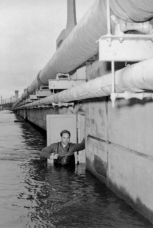
Manville was severely hit by a flood in the wake of Hurricane Floyd in September 1999, which dropped 10 to 12 inches (250 to 300 mm) of rain in the areas surrounding the borough. The floods devastated the Lost Valley section, some of the South side area along Main Street and a large portion of the North side. Water levels reached between 12 feet (3.7 m) and 17 feet (5.2 m) in parts of the borough on September 17, 1999. The only way residents could get help was by boat or helicopter. There was also a large amount of fuel oil floating on the flood water which further damaged homes, many of which came off their foundations.
A portion of the north side received water coming from the Raritan at Dukes Parkway. Much of the north side had no flooding. The water reached the freight tracks at Main Street, and spilled over, flooding some on the South Street side, but leaving tons of water dammed in on the North Street side, where people had to be rescued from rooftops, or second floor windows and landings, by boat.
The problem was doubled in the Lost Valley section, as flood waters backed up where the Raritan and Millstone rivers meet near the dam. All trapped and injured people had to be taken out by helicopter, as there was no way to get in or out of the Lost Valley section. The September 1999 flood disaster was the worst ever to hit Manville, although it had been flooded in 1971 during Tropical Storm Doria, when many of the Lost Valley houses were destroyed and their foundations lost, and previously before that in the 1950s. Because of the railroad tracks being so much higher than the Lost Valley land, Manville's Lost Valley will always be a number one target for flooding. Through research of Manville's history, Lost Valley was to remain open land due to the high risk of flood.
Lost Valley flooding
Manville has the distinction of being the location where the Raritan River (which passes to the north) and the tributary Millstone River (which passes to the east) join together, in the far northeastern corner of the borough. The Lost Valley section in eastern Manville is situated on the natural flood plain between the Raritan and Millstone Rivers, and bears the brunt of occasional flooding events which affect the river basins. The Lost Valley section is named so because it is generally disconnected from the rest of the borough with only a tunnel at Kyle Street and a bridge at Bridge Street crossing the railroad tracks to the neighborhood.[98] Hurricane Floyd in September 1999 produced a particularly severe flood (a record for the river basins) in Manville, especially in the Lost Valley section of the borough, which experienced flooding all the way to the railroad tracks, with twelve feet or more water on many properties, which inundated houses with damaging flood waters. Another severe and devastating flood event occurred in Lost Valley during the April 2007 Nor'easter. It also left many homes and businesses underwater and was the worst flood since Hurricane Floyd. Flooding problems once again occurred in Manville on March 14, 2010, with rivers running already high due to recent snow melt along with 3 to 4 inches (76 to 102 mm) of rain that fell on the area on March 13, flooding was inevitable. More extensive flooding affected Manville in August 2011 when Hurricane Irene passed through New Jersey.[99] In the aftermath of Hurricane Sandy in late October 2012, Manville did not flood but the powerful winds left many homes without power for several days.[100]
Hurricane Ida floods
On September 1, 2021, the tropical remains of Hurricane Ida swept through Manville, causing floods in the majority of the town. The nearby Raritan river was flooded to a record 27.66 feet (8.43 m), shattering the previous 27.1 feet recorded by Hurricane Floyd.[101] On September 2, 2021, a house on Boesel Avenue exploded after the residents of the home had already evacuated, and nearby on North Second Avenue, another exploded and engulfed a home next to it, burning down as firefighters were unable to access the home due to the heavy floodwaters.[102] That night, a local banquet hall, The Saffron, exploded and burned to the ground early Friday morning.[103]
Flood gauge on Raritan River
Flooding occurs at a 14-foot (4.3 m) stage, and severe flooding occurs when the water reaches 18 feet (5.5 m). The National Oceanic and Atmospheric Administration provides access to real time river level data.[104]
Notable people
People who were born in, residents of, or otherwise closely associated with Manville include:
- Cheryl Chase (born 1958), voice actress[105]
- Joe Lis (1946–2010), Major League Baseball player[106]
- Joseph D. Patero (1932–2020), politician who served as mayor of Manville and in the New Jersey General Assembly from 1974 to 1986 and from 1988 to 1991[107]
- Edward Rogalski (born 1942), 12th president of St. Ambrose University in Davenport, Iowa, named in 1987[108]
- Theo Riddick (born 1991), professional football player for the Las Vegas Raiders[109]
- Robert Sikoryak (born 1964), cartoonist[110]
References
- 2019 Census Gazetteer Files: New Jersey Places, United States Census Bureau. Accessed July 1, 2020.
- US Gazetteer files: 2010, 2000, and 1990, United States Census Bureau. Accessed September 4, 2014.
- 2012 New Jersey Legislative District Data Book, Rutgers University Edward J. Bloustein School of Planning and Public Policy, March 2013, pg. 77.
- Mayor & Council, Borough of Manville. Accessed June 22, 2022. "The Mayor is appointed for a 4-year term, where council members are appointed for a 3 year term."
- 2022 New Jersey Mayors Directory, New Jersey Department of Community Affairs. Accessed March 1, 2022.
- Administration, Borough of Manville. Accessed June 22, 2022.
- Clerk's Office, Borough of Manville. Accessed June 22, 2022.
- "ArcGIS REST Services Directory". United States Census Bureau. Retrieved October 11, 2022.
- U.S. Geological Survey Geographic Names Information System: Borough of Manville, Geographic Names Information System. Accessed March 7, 2013.
- "Census Population API". United States Census Bureau. Retrieved October 11, 2022.
- GCT-PH1 Population, Housing Units, Area, and Density: 2010 - State -- County Subdivision from the 2010 Census Summary File 1 for New Jersey Archived 2020-02-12 at archive.today, United States Census Bureau. Accessed February 13, 2013.
- Look Up a ZIP Code for Manville, NJ, United States Postal Service. Accessed February 13, 2013.
- Zip Codes, State of New Jersey. Accessed August 28, 2013.
- Area Code Lookup - NPA NXX for Manville, NJ, Area-Codes.com. Accessed October 1, 2014.
- U.S. Census website , United States Census Bureau. Accessed September 4, 2014.
- Geographic Codes Lookup for New Jersey, Missouri Census Data Center. Accessed April 1, 2022.
- US Board on Geographic Names, United States Geological Survey. Accessed September 4, 2014.
- DP-1 - Profile of General Population and Housing Characteristics: 2010 for Manville borough, Somerset County, New Jersey Archived 2020-02-12 at archive.today, United States Census Bureau. Accessed February 13, 2013.
- Municipalities Sorted by 2011-2020 Legislative District, New Jersey Department of State. Accessed February 1, 2020.
- Profile of General Demographic Characteristics: 2010 for Manville borough[permanent dead link], New Jersey Department of Labor and Workforce Development. Accessed February 13, 2013.
- Table 7. Population for the Counties and Municipalities in New Jersey: 1990, 2000 and 2010, New Jersey Department of Labor and Workforce Development, February 2011. Accessed February 13, 2013.
- Polish Ancestry Archived 2011-06-02 at the Wayback Machine, EPodunk. Accessed May 3, 2007.
- Snyder, John P. The Story of New Jersey's Civil Boundaries: 1606-1968, Bureau of Geology and Topography; Trenton, New Jersey; 1969. p. 223. Accessed October 28, 2012.
- Locality Search, State of New Jersey. Accessed May 21, 2015.
- Areas touching Manville, MapIt. Accessed February 26, 2020.
- Municipalities, Somerset County, New Jersey. Accessed February 26, 2020.
- New Jersey Municipal Boundaries, New Jersey Department of Transportation. Accessed November 15, 2019.
- U.S. Potential Natural Vegetation, Original Kuchler Types, v2.0 (Spatially Adjusted to Correct Geometric Distortions), Data Basin. Accessed November 5, 2020.
- Fifteenth Census of the United States : 1930 - Population Volume I, United States Census Bureau, p. 718. Accessed February 13, 2013.
- Table 6. New Jersey Resident Population by Municipality: 1930 - 1990 Archived March 19, 2018, at the Wayback Machine, New Jersey Department of Labor and Workforce Development. Accessed June 28, 2015.
- Census 2000 Profiles of Demographic / Social / Economic / Housing Characteristics for Manville borough, New Jersey Archived 2017-01-06 at the Wayback Machine, United States Census Bureau. Accessed February 13, 2013.
- DP-1: Profile of General Demographic Characteristics: 2000 - Census 2000 Summary File 1 (SF 1) 100-Percent Data for Manville borough, Somerset County, New Jersey Archived 2020-02-12 at archive.today, United States Census Bureau. Accessed February 13, 2013.
- DP03: Selected Economic Characteristics from the 2006-2010 American Community Survey 5-Year Estimates for Manville borough, Somerset County, New Jersey Archived 2020-02-12 at archive.today, United States Census Bureau. Accessed February 13, 2013.
- Inventory of Municipal Forms of Government in New Jersey, Rutgers University Center for Government Studies, July 1, 2011. Accessed November 18, 2019.
- Cerra, Michael F. "Forms of Government: Everything You've Always Wanted to Know, But Were Afraid to Ask" Archived 2014-09-24 at the Wayback Machine, New Jersey State League of Municipalities. Accessed November 30, 2014.
- "Forms of Municipal Government in New Jersey", pg. 6. Rutgers University Center for Government Studies. Accessed June 3, 2015.
- 2022 Municipal Data Sheet, Borough of Manville. Accessed June 22, 2022.
- 2021 Directory of County & Municipal Offices, Somerset County, New Jersey. Accessed May 1, 2022.
- 2021 General Election Winning Candidates, Somerset County, New Jersey. Accessed January 1, 2022.
- Somerset County General Election November 3, 2020 Final Certified Results, Somerset County, New Jersey, dated December 3, 2020. Accessed January 19, 2021.
- General Election November 5, 2019 Final Results, Somerset County, New Jersey, updated November 15, 2019. Accessed January 1, 2020.
- Paik, Eugene. "Longtime Manville mayor takes back his seat", The Star-Ledger, November 8, 2011. Accessed November 9, 2011. "Voters in Manville tonight returned former Mayor Angelo Corradino to the office that made him one of the borough's political heavyweights. Corradino, who steered Manville for 16 years before an election loss in 2007, defeated Republican Councilwoman Susan Asher 1,007 to 990, according to unofficial results."
- Plan Components Report, New Jersey Redistricting Commission, December 23, 2011. Accessed February 1, 2020.
- 2019 New Jersey Citizen's Guide to Government, New Jersey League of Women Voters. Accessed October 30, 2019.
- Districts by Number for 2011-2020, New Jersey Legislature. Accessed January 6, 2013.
- 2011 New Jersey Citizen's Guide to Government Archived 2013-06-04 at the Wayback Machine, p. 60, New Jersey League of Women Voters. Accessed May 22, 2015.
- Directory of Representatives: New Jersey, United States House of Representatives. Accessed January 3, 2019.
- Biography, Congresswoman Bonnie Watson Coleman. Accessed January 3, 2019. "Watson Coleman and her husband William reside in Ewing Township and are blessed to have three sons; William, Troy, and Jared and three grandchildren; William, Kamryn and Ashanee."
- U.S. Sen. Cory Booker cruises past Republican challenger Rik Mehta in New Jersey, PhillyVoice. Accessed April 30, 2021. "He now owns a home and lives in Newark's Central Ward community."
- Biography of Bob Menendez, United States Senate, January 26, 2015. "Menendez, who started his political career in Union City, moved in September from Paramus to one of Harrison's new apartment buildings near the town's PATH station.."
- Home, sweet home: Bob Menendez back in Hudson County. nj.com. Accessed April 30, 2021. "Booker, Cory A. - (D - NJ) Class II; Menendez, Robert - (D - NJ) Class I"
- Legislative Roster for District 16, New Jersey Legislature. Accessed January 11, 2022.
- Elected Officials, Somerset County, New Jersey. Accessed June 17, 2022.
- Commissioner Director Shanel Y. Robinson, Somerset County, New Jersey. Accessed June 17, 2022.
- Commissioner Deputy Director Melonie Marano, Somerset County, New Jersey. Accessed June 17, 2022.
- Commissioner Paul M. Drake, Somerset County, New Jersey. Accessed June 17, 2022.
- Commissioner Douglas Singleterry, Somerset County, New Jersey. Accessed June 17, 2022.
- Commissioner Sara Sooy, Somerset County, New Jersey. Accessed June 17, 2022.
- Board of County Commissioners, Somerset County, New Jersey. Accessed June 17, 2022.
- 2021 County Data Sheet, Somerset County, New Jersey. Accessed June 17, 2022.
- 2021 Directory of County & Municipal Offices, Somerset County, New Jersey. Accessed May 1, 2022.
- 2021 General Election Winning Candidates, Somerset County, New Jersey. Accessed January 1, 2022.
- Somerset County General Election November 3, 2020 Final Certified Results, Somerset County, New Jersey, dated December 3, 2020. Accessed January 1, 2021.
- General Election November 5, 2019 Final Results, Somerset County, New Jersey, updated November 15, 2019. Accessed January 1, 2020.
- New Jersey State Constitution (1947), Article VII, Section II, Paragraph 2, New Jersey Department of State. Accessed June 17, 2022.
- County Clerk Steve Peter, Somerset County, New Jersey. Accessed June 17, 2022.
- Clerks, Constitutional Officers Association of New Jersey. Accessed June 17, 2022.
- Sheriff Darrin J. Russo, Somerset County, New Jersey. Accessed June 17, 2022.
- Sheriffs, Constitutional Officers Association of New Jersey. Accessed June 17, 2022.
- Somerset County Surrogate, Somerset County, New Jersey. Accessed January 30, 2021.
- Surrogates, Constitutional Officers Association of New Jersey. Accessed June 17, 2022.
- Voter Registration Summary - Somerset, New Jersey Department of State Division of Elections, March 23, 2011. Accessed February 13, 2013.
- GCT-P7: Selected Age Groups: 2010 - State -- County Subdivision; 2010 Census Summary File 1 for New Jersey Archived 2020-02-12 at archive.today, United States Census Bureau. Accessed February 13, 2013.
- "Presidential General Election Results - November 6, 2012 - Somerset County" (PDF). New Jersey Department of Elections. March 15, 2013. Retrieved December 24, 2014.
- "Number of Registered Voters and Ballots Cast - November 6, 2012 - General Election Results - Somerset County" (PDF). New Jersey Department of Elections. March 15, 2013. Retrieved December 24, 2014.
- 2008 Presidential General Election Results: Somerset County, New Jersey Department of State Division of Elections, December 23, 2008. Accessed February 13, 2013.
- 2004 Presidential Election: Somerset County, New Jersey Department of State Division of Elections, December 13, 2004. Accessed February 13, 2013.
- "Governor - Somerset County" (PDF). New Jersey Department of Elections. January 29, 2014. Retrieved December 24, 2014.
- "Number of Registered Voters and Ballots Cast - November 5, 2013 - General Election Results - Somerset County" (PDF). New Jersey Department of Elections. January 29, 2014. Retrieved December 24, 2014.
- 2009 Governor: Somerset County Archived 2015-02-02 at the Wayback Machine, New Jersey Department of State Division of Elections, December 31, 2009. Accessed February 13, 2013.
- Manville Board of Education District Policy 0110 - Identification, Manville School District. Accessed February 13, 2022. "Purpose: The Board of Education exists for the purpose of providing a thorough and efficient system of free public education in grades Pre-Kindergarten through twelve in the Manville School District. Composition: The Manville School District is comprised of all the area within the municipal boundaries of Manville in the County of Somerset."
- District information for Manville School District, National Center for Education Statistics. Accessed April 1, 2021.
- School Data for the Manville School District, National Center for Education Statistics. Accessed April 1, 2021.
- Weston Elementary School, Manville School District. Accessed February 13, 2022.
- Roosevelt Elementary School, Manville School District. Accessed February 13, 2022.
- Alexander Batcho Intermediate School, Manville School District. Accessed February 13, 2022.
- Manville High School, Manville School District. Accessed February 13, 2022.
- 2021-2022 Somerset County Public School Directory, Somerset County, New Jersey. Accessed February 13, 2022.
- School Performance Reports for the Manville School District, New Jersey Department of Education. Accessed February 13, 2022.
- New Jersey School Directory for the Manville School District, New Jersey Department of Education. Accessed December 29, 2016.
- Hutchinson, Dave. "Manville's Christ the King School to close because of low enrollment", NJ Advance Media for NJ.com, January 13, 2015. Accessed September 5, 2017. "Christ the King School, which opened its doors on Sept. 6, 1968, is closing following the current school year. The closing is due to low enrollment, the Rev. Stanislaw, pastor of Christ the Redeemer Parish announced in a press release on Tuesday. During an open parish meeting on Monday night, Slaby informed parishioners of the decision, saying the operation of the school has resulted in a parish deficit of more than $1 million over the past five years and continuing to subsidize the school could threaten the very existence of the parish, according to the announcement."
- Somerset County Mileage by Municipality and Jurisdiction, New Jersey Department of Transportation, May 2010. Accessed July 18, 2014.
- SCOOT, Ridewise. Accessed October 2, 2014.
- Port Reading Junction, New Jersey Department of Transportation. Accessed August 17, 2020. "Project description: The New Jersey Department of Transportation (NJDOT) will address a major chokepoint in the region's rail system by reconfiguring the Port Reading Junction to provide double track train operations between the CSX - West Trenton line and the Norfolk Southern - Lehigh line.... Location: Manville Borough in Somerset County"
- The Federal Creosote Site
- "Cleanup Completed at Federal Creosote Superfund Site", United States Environmental Protection Agency press release dated March 7, 2008. Accessed March 8, 2008.
- Flood Control Feasibility Study for Manville, NJ Archived 2006-05-25 at the Wayback Machine, United States Army Corps of Engineers.
- Craven, Laura. "Manville residents still fear flooding 10 years after Hurricane Floyd", The Star-Ledger, September 13, 2009. Accessed June 22, 2022.
- Stirling, Stephen. "Hurricane Irene leads to historic flooding after month's record rainfall", The Star-Ledger, August 29, 2011. Accessed February 2, 2015. "Hurricane Irene has come and gone, but in many parts of New Jersey, destructive flooding remains. While it's too soon to know cost of the massive storm, property damage and loss in Manville will be massive."
- Paik, Eugene. "Hurricane Sandy: Manville's challenge is different this time", The Star-Ledger, October 28, 2012. Accessed February 2, 2015.
- NJ.com, Bill Duhart | For (September 2, 2021). "Here's the awful scene from above in Manville, where flooding again overran this N.J. town". nj. Retrieved September 3, 2021.
- "Homes Destroyed by Fire, Flooding in Manville, New Jersey", WNBC-TV, September 3, 2021. Accessed June 22, 2022.
- Torrejon, Rodrigo; and Kausch, Katie. "Homes, banquet hall burn to ground in Manville as flooded roads block firefighters", NJ Advance Media for NJ.com, September 3, 2021. Accessed June 22, 2022. "Two houses and a banquet hall in Manville were still visibly burning Friday morning as news helicopters circled overhead. Abc7ny.com reported, The Saffron, a banquet hall on South Main Street, burst into flames at around 2 a.m."
- NOAA Flood gauge in Manville, NJ on Raritan River, National Oceanic and Atmospheric Administration. Accessed May 6, 2015.
- Bonko, Larry. "Voice Talents" Toils Anonymously, The Virginian-Pilot, July 20, 2001, accessed April 13, 2007. "Cheryl Chase, a native of Manville, N.J., is probably the biggest TV star you never heard of."
- Joe Lis, Society for American Baseball Research. Accessed June 4, 2020. "Joe was born to Henry and Anna Lis on August 15, 1946, at Somerset Hospital in Somerville, New Jersey. The Lis family lived in the nearby blue-collar town of Manville, home of the Johns-Manville Corporation, a leading manufacturer of asbestos products."
- Wildstein, David. "Joseph Patero, former Assembly Labor Committee chairman, dies at 88; Somerset Democrat sponsored family leave legislation in New Jersey", New Jersey Globe, June 23, 2020. Accessed August 17, 2020. "Joseph D. Patero, who served eight terms in the State Assembly and was the sponsor of landmark legislation to establish paid family leave in New Jersey, died on June 20 at his home in Manville. He was 88."
- Flansburg, Susan. "The Rogalski Generation", SCENE Magazine of St. Ambrose University, Summer 2007. Accessed June 12, 2017. "Born Feb. 16, 1942, to Polish immigrants in Manville, N.J., Ed Rogalski was the youngest of eight children."
- Paczesny, Kevin. "Getting To Know ... Wide Receiver Theo Riddick", Notre Dame Fighting Irish football, September 9, 2010. Accessed September 26, 2014. ""Getting To Know ... Wide Receiver Theo Riddick No. 6 * 5-11 * 198 * So. - Manville, N.J./Immaculata"
- Sikoryak, Joe. [https://www.newschool.edu/parsons/faculty/robert-sikoryak/}
External links
Municipalities and communities of Somerset County, New Jersey, United States | ||
|---|---|---|
County seat: Somerville | ||
| Boroughs |  | |
| Townships | ||
| CDPs |
| |
| Other communities |
| |
| Footnotes | ‡This populated place also has portions in an adjacent county or counties | |
| ||
Authority control | |
|---|---|
| General | |
| National libraries | |
| Other |
|
На других языках
[de] Manville (New Jersey)
Manville ist eine Stadt im Somerset County, New Jersey, USA. Bei der Volkszählung von 2000 wurde eine Bevölkerungszahl von 10.343 registriert.- [en] Manville, New Jersey
Другой контент может иметь иную лицензию. Перед использованием материалов сайта WikiSort.org внимательно изучите правила лицензирования конкретных элементов наполнения сайта.
WikiSort.org - проект по пересортировке и дополнению контента Википедии