world.wikisort.org - USA
Looxahoma is an unincorporated community in Tate County, Mississippi, United States. Looxahoma is located approximately 8 miles (13 km) east of Senatobia and approximately 8 miles (13 km) west of Tyro near Mississippi Highway 4.
Looxahoma, Mississippi | |
|---|---|
Unincorporated community | |
 | |
 Looxahoma, Mississippi  Looxahoma, Mississippi | |
| Coordinates: 34°35′50″N 89°50′13″W | |
| Country | United States |
| State | Mississippi |
| County | Tate |
| Elevation | 381 ft (116 m) |
| Time zone | UTC-6 (Central (CST)) |
| • Summer (DST) | UTC-5 (CDT) |
| ZIP code | 38668 |
| Area code(s) | 662 |
| GNIS feature ID | 672865[1] |
Looxahoma is a name derived from the Chickasaw language meaning "red turtle".[2]
References
Wikimedia Commons has media related to Looxahoma, Mississippi.
- U.S. Geological Survey Geographic Names Information System: Looxahoma, Mississippi
- Baca, Keith A. (2007). Native American Place Names in Mississippi. University Press of Mississippi. p. 51. ISBN 978-1-60473-483-6.
Municipalities and communities of Tate County, Mississippi, United States | ||
|---|---|---|
County seat: Senatobia | ||
| City | 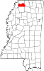 | |
| Town |
| |
| CDPs |
| |
| Other communities |
| |
| ||
City of Memphis and Memphis metropolitan area (counties in TN, MS and AR) | |||||||
|---|---|---|---|---|---|---|---|
| Topics |
| ||||||
| Districts |
| ||||||
| Neighborhoods |
| ||||||
Metro area landmarks |
| ||||||
Metro area suburbs |
| ||||||
Metro area counties |
| ||||||
See also: Memphis, Tennessee sports venues | |||||||


This Tate County, Mississippi state location article is a stub. You can help Wikipedia by expanding it. |
Текст в блоке "Читать" взят с сайта "Википедия" и доступен по лицензии Creative Commons Attribution-ShareAlike; в отдельных случаях могут действовать дополнительные условия.
Другой контент может иметь иную лицензию. Перед использованием материалов сайта WikiSort.org внимательно изучите правила лицензирования конкретных элементов наполнения сайта.
Другой контент может иметь иную лицензию. Перед использованием материалов сайта WikiSort.org внимательно изучите правила лицензирования конкретных элементов наполнения сайта.
2019-2026
WikiSort.org - проект по пересортировке и дополнению контента Википедии
WikiSort.org - проект по пересортировке и дополнению контента Википедии