world.wikisort.org - USA
Kenilworth is a census-designated place in northern Carbon County, Utah, United States.
Kenilworth, Utah | |
|---|---|
Census-designated place | |
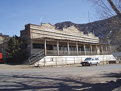 Kenilworth's Old Company Store, March 2008 | |
 Location in Carbon County and the state of Utah | |
| Coordinates: 39°40′49″N 110°48′52″W | |
| Country | United States |
| State | Utah |
| County | Carbon |
| Founded | 1908 |
| Named for | Kenilworth Castle |
| Area | |
| • Total | 0.75 sq mi (1.95 km2) |
| • Land | 0.75 sq mi (1.95 km2) |
| • Water | 0.0 sq mi (0.0 km2) |
| Elevation | 6,316 ft (1,925 m) |
| Population (2010)[2] | |
| • Total | 180 |
| • Density | 239/sq mi (92.4/km2) |
| GNIS feature ID | 2584769[1] |
Description
The community lies at the eastern end of State Route 157, north of the city of Price, the county seat of Carbon County.[3] Kenilworth has a post office with the ZIP code 84529.[4] The population was 180 at the 2010 census.[2]
History
Like many communities in Carbon County, Kenilworth began as a coal mining camp. Coal was first discovered in the area in 1904, and the town site was laid out in 1908. The name Kenilworth was given by British miners who thought the mountain peaks overlooking the area resembled the spires of Kenilworth Castle.
Demographics
The population was about 500 in 1910, rose to a high of 1,050 in 1947, and at the 1990 census was down to 350.
As of the census[5] of 2010, there were 180 people living in the CDP. There were 112 housing units. The racial makeup of the town was 92.8% White, 5.0% from some other race, and 2.2% from two or more races. Hispanic or Latino of any race were 20.0% of the population.
Climate
This climatic region is typified by large seasonal temperature differences, with warm to hot (and often humid) summers and cold (sometimes severely cold) winters. According to the Köppen Climate Classification system, Kenilworth has a humid continental climate, abbreviated "Dfb" on climate maps.[6]
Gallery
 Approaching Kenilworth
 Part of company housing project, Independent Coal & Coke Company, Kenilworth Mine, Kenilworth, 1946


See also
- List of census-designated places in Utah
References
- U.S. Geological Survey Geographic Names Information System: Kenilworth
- "Geographic Identifiers: 2010 Census Summary File 1 (G001): Kenilworth CDP, Utah". U.S. Census Bureau, American Factfinder. Archived from the original on February 13, 2020. Retrieved August 11, 2015.
- Rand McNally. The Road Atlas '08. Chicago: Rand McNally, 2008, pp. 102, 103.
- USPS – Cities by ZIP Code
- "U.S. Census website". United States Census Bureau. Retrieved May 23, 2011.
- Climate Summary for Kenilworth, Utah
External links
![]() Media related to Kenilworth, Utah at Wikimedia Commons
Media related to Kenilworth, Utah at Wikimedia Commons
Municipalities and communities of Carbon County, Utah, United States | ||
|---|---|---|
County seat: Price | ||
| Cities |
|  |
| Town |
| |
| CDPs |
| |
| Indian reservation |
| |
| Ghost towns |
| |
| Footnotes | ‡This populated place also has portions in an adjacent county or counties | |
| ||
This article about a location in Utah is a stub. You can help Wikipedia by expanding it. |
Другой контент может иметь иную лицензию. Перед использованием материалов сайта WikiSort.org внимательно изучите правила лицензирования конкретных элементов наполнения сайта.
WikiSort.org - проект по пересортировке и дополнению контента Википедии