world.wikisort.org - USA
Kāneʻohe (Hawaiian pronunciation: [kaːneˈʔohe]) is a census-designated place (CDP) included in the City and County of Honolulu and located in Hawaiʻi state District of Koʻolaupoko on the island of Oʻahu. In the Hawaiian language, kāne ʻohe means "bamboo man". According to an ancient Hawaiian story a local woman compared her husband's cruelty to the sharp edge of cutting bamboo; thus the place was named Kāneʻohe or "bamboo man". The population was 37,430 at the 2020 census. Kāneʻohe is the largest of several communities along Kāneʻohe Bay and one of the two largest residential communities on the windward side of Oʻahu (the other is Kailua). The commercial center of the town is spread mostly along Kamehameha Highway.
Kāneʻohe | |
|---|---|
Census-designated place | |
| Kāneʻohe | |
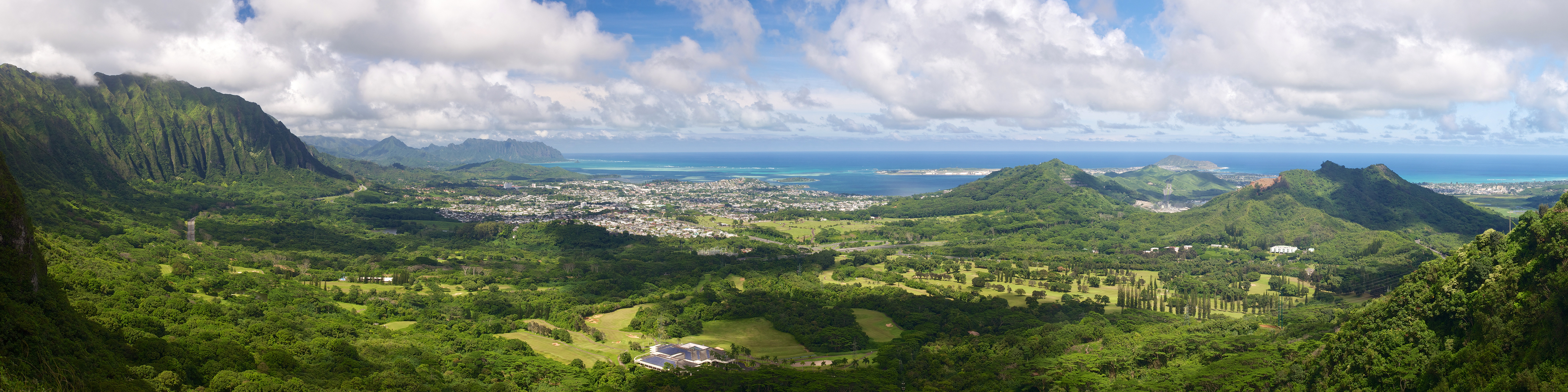 View from the Nuʻuanu Pali Lookout of Kaneʻohe | |
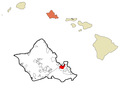 Location in Honolulu County and the state of Hawaii | |
 Kāneʻohe Location in Hawaii | |
| Coordinates: 21°24′33″N 157°47′57″W | |
| Country | |
| State | |
| County | |
| Area | |
| • Total | 8.46 sq mi (21.91 km2) |
| • Land | 6.54 sq mi (16.95 km2) |
| • Water | 1.92 sq mi (4.97 km2) |
| Elevation | 92 ft (28 m) |
| Population (2020) | |
| • Total | 37,430 |
| • Density | 5,720.62/sq mi (2,208.90/km2) |
| Time zone | UTC-10 (Hawaiian Standard Time HST) |
| ZIP code | 96744 |
| Area code | 808 |
| FIPS code | 15-28250 |
| GNIS feature ID | 0360391 |

From ancient times, Kāneʻohe was important as an agricultural area, owing to an abundance of rainfall. Today, Kāneʻohe is mostly a residential community, with very little agriculture in evidence. The only commercial crop of any consequence in the area is banana.
Features of note are Hoʻomaluhia Botanical Garden and the new Hawaiʻi National Veterans Cemetery. Access to Kāneʻohe Bay is mainly from the public pier and boat ramp located at nearby Heʻeia Kea. Access to Coconut Island (restricted) is from the state pier off Lilipuna Road. Marine Corps Base Hawaii lies across the south end of Kāneʻohe Bay from the central part of Kāneʻohe, although the town stretches along Kāneʻohe Bay Drive to the base perimeter.
There are three golf courses in Kāneʻohe: Pali Golf Course (public), Koʻolau Golf Club (privately owned but open to the public), and Bayview Golf Park (privately owned but open to the public).
History
Kāneʻohe was home to the early rulers of the Hawaiian Kingdom and consisted of 30 royal fishponds. It was originally an agricultural area for the growing of taro and sweet potatoes.
Geography
Kāneʻohe is located at 21°24′33″N 157°47′57″W (21.409200, -157.799084).[2] Nearby towns include Kailua to the east, reached either by Kāneʻohe Bay Drive (State Rte. 630) or Kamehameha Highway (State Rte. 83), the former also providing a connection to Marine Corps Base Hawaii, and the latter connecting to Interstate H-3 and (at Castle Junction) Pali Highway (State Rte. 61) to Honolulu. Likelike Highway (State Rte. 63) runs southwest over and through the Koʻolau to Honolulu. Likelike provides connections to Kahekili Highway and Heʻeia, and H-3 southbound to Hālawa. The first three exits on the windward side of Interstate H-3 east (north) bound access Kāneʻohe. Following Kamehameha Highway northward from Kāneʻohe (State Rte. 830) leads through Heʻeia to Heʻeia Kea.
According to the United States Census Bureau, the CDP has a total area of 8.5 square miles (22 km2), of which 6.6 square miles (17 km2) is land and 1.9 square miles (4.9 km2) is water. The total area is 22.80% water, consisting of a portion of Kāneʻohe Bay included in the census tract.
Climate
Kaneohe has a tropical steppe climate.
| Climate data for Kaneohe, Hawaii (Marine Corps Base Hawaii) 1991–2020 normals, extremes 1942–present | |||||||||||||
|---|---|---|---|---|---|---|---|---|---|---|---|---|---|
| Month | Jan | Feb | Mar | Apr | May | Jun | Jul | Aug | Sep | Oct | Nov | Dec | Year |
| Record high °F (°C) | 89 (32) |
88 (31) |
95 (35) |
88 (31) |
88 (31) |
90 (32) |
93 (34) |
94 (34) |
95 (35) |
91 (33) |
91 (33) |
91 (33) |
95 (35) |
| Average high °F (°C) | 78.5 (25.8) |
78.0 (25.6) |
78.3 (25.7) |
79.6 (26.4) |
81.0 (27.2) |
82.3 (27.9) |
83.4 (28.6) |
84.1 (28.9) |
84.1 (28.9) |
83.3 (28.5) |
81.2 (27.3) |
79.1 (26.2) |
81.1 (27.3) |
| Daily mean °F (°C) | 73.3 (22.9) |
73.2 (22.9) |
73.7 (23.2) |
75.2 (24.0) |
76.5 (24.7) |
78.1 (25.6) |
79.1 (26.2) |
79.8 (26.6) |
79.9 (26.6) |
79.1 (26.2) |
76.9 (24.9) |
74.7 (23.7) |
76.6 (24.8) |
| Average low °F (°C) | 68.1 (20.1) |
68.5 (20.3) |
69.1 (20.6) |
70.8 (21.6) |
72.0 (22.2) |
73.9 (23.3) |
74.8 (23.8) |
75.4 (24.1) |
75.6 (24.2) |
74.8 (23.8) |
72.5 (22.5) |
70.3 (21.3) |
72.1 (22.3) |
| Record low °F (°C) | 54 (12) |
55 (13) |
54 (12) |
60 (16) |
60 (16) |
66 (19) |
62 (17) |
68 (20) |
66 (19) |
61 (16) |
57 (14) |
55 (13) |
54 (12) |
| Average rainfall inches (mm) | 2.81 (71) |
3.16 (80) |
3.62 (92) |
1.62 (41) |
1.32 (34) |
1.27 (32) |
1.31 (33) |
1.42 (36) |
1.50 (38) |
2.58 (66) |
3.68 (93) |
3.53 (90) |
27.82 (707) |
| Average rainy days (≥ 0.01 in) | 11.7 | 9.4 | 13.0 | 13.0 | 11.4 | 13.5 | 16.2 | 12.1 | 13.4 | 14.8 | 14.5 | 14.8 | 157.8 |
| Source: NOAA[3][4] | |||||||||||||
Demographics
| Historical population | |||
|---|---|---|---|
| Census | Pop. | %± | |
| 2020 | 37,430 | — | |
| U.S. Decennial Census[5] | |||
As of the 2000 Census, there were 34,970 people, 10,976 households, and 8,682 families residing in Kāneʻohe. The population density was 5,320.7 inhabitants per square mile (2,054.3/km2). There were 11,472 housing units at an average density of 1,745.5 per square mile (673.9/km2). The racial makeup of the CDP was 20.49% White, 0.81% Black, 0.20% Native American, 38.48% Asian, 11.44% Pacific Islander, 0.68% from other races, and 27.90% from two or more races. 7.21% of the population were Hispanic or Latino of any race.
Of the 10,976 households 32.7% had children under the age of 18 living with them, 60.4% were married couples living together, 13.7% had a female householder with no husband present, and 20.9% were non-families. 15.4% of households were one person and 6.5% had someone living alone who was 65 or older. The average household size was 3.14 and the average family size was 3.48.
The age distribution was 24.6% under the age of 18, 8.2% from 18 to 24, 29.0% from 25 to 44, 23.4% from 45 to 64, and 14.7% 65 or older. The median age was 38 years. For every 100 females, there were 96.1 males. For every 100 females age 18 and over, there were 93.2 males.
The median household income was in Kāneʻohe in 2000 was $66,006, and the median family income was $71,316. Males had a median income of $40,389 versus $31,504 for females. The per capita income for the CDP was $23,476. 6.1% of the population and 4.4% of families were below the poverty line. Out of the total population, 7.3% of those under the age of 18 and 4.2% of those 65 and older were living below the poverty line.
Government and infrastructure
The Honolulu Police Department operates the Kaneohe Substation in Kaneohe.[6]
Education
The Hawaii Department of Education operates the public schools.[7]
Elementary schools in Kaneohe CDP include Heʻeia,[8] Kāneʻohe,[9] Kapunahala,[10] Reverend Benjamin Parker,[11] and Pūʻōhala.[12] James B. Castle High School is in the CDP.[13]
Schools with Kaneohe postal addresses but outside of the CDP include Governor Samuel Wilder King Intermediate School in Heeia CDP,[14][15] ʻĀhuimanu Elementary School adjacent to, but not in, Ahuimanu CDP,[16][17] Kahalu'u Elementary School in Kahalu'u CDP,[18][19] and Waiāhole Elementary School in Waikane.[20][21]
There is the Hakipuʻu Learning Center, a public charter school for grades 7 through 12.[citation needed]
The Roman Catholic Diocese of Honolulu operates St. Ann Catholic School, K-8, in Heeia CDP but with a Kaneohe address.[15][22]
Also within the boundaries of Kaneohe CDP are these private schools: Huakailani School for Girls (K-8),[23] Koʻolau Baptist Academy, St Mark Lutheran School, and Windward Nazarene Academy.[citation needed]
Windward Community College, part of the state college system, is located on the south side of central Kāneʻohe. Hawaiʻi Pacific University operates its Windward Hawaiʻi Loa campus on Kamehameha Highway near Castle Junction.
Notable people
- Kimee Balmilero, actor
- Bryan Clay, decathlete, Olympic Gold Medalist
- Aloha Dalire, kumu hula and hula dancer, first Miss Aloha Hula winner (1971)[24]
- Alika DeRego, Volleyball player, U.S. Open national champion
- Carlos Diaz, former Major League Baseball relief pitcher who played for the Atlanta Braves, New York Mets, and Los Angeles Dodgers[25]
- Caitlin Doughty, mortician, author, and YouTube personality
- Blane Gaison, former National Football League player
- Ann Harada, actress[26]
- Don Ho, singer and entertainer
- Lisa Kitagawa, member of the Hawaii House of Representatives
- Colleen Meyer, Hawaii state legislator and businesswoman
- Janel Parrish, actress and singer
References
- "2020 U.S. Gazetteer Files". United States Census Bureau. Retrieved December 18, 2021.
- "US Gazetteer files: 2010, 2000, and 1990". United States Census Bureau. 2011-02-12. Retrieved 2011-04-23.
- "NowData - NOAA Online Weather Data". National Oceanic and Atmospheric Administration. Retrieved September 11, 2021.
- "Station: Janeohe Bay MCAS, HI". U.S. Climate Normals 2020: U.S. Monthly Climate Normals (1991-2020). National Oceanic and Atmospheric Administration. Retrieved September 11, 2021.
- "Census of Population and Housing". Census.gov. Retrieved June 4, 2016.
- "Contacting HPD Archived 2010-05-31 at the Wayback Machine." Honolulu Police Department. Retrieved on May 19, 2010.
- "2010 CENSUS - CENSUS BLOCK MAP: Kaneohe CDP, HI" (PDF). U.S. Census Bureau. Retrieved 2020-10-09.
2000 Map: "CENSUS 2000 BLOCK MAP: KANEOHE CDP" (PDF). U.S. Census Bureau. Retrieved 2020-10-09. - Pages: 1 and 2 - Compare with postal addresses of schools. - "Home". Heeia Elementary School. Retrieved 2020-10-09.
46-202 Haiku Road Kaneohe, HI 96744
- "Home". Kaneohe Elementary School. Retrieved 2020-10-09.
45-495 Kamehameha Highway Kāne‘ohe, Hawaii 96744
- "Home". Kapunahala Elementary School. Retrieved 2020-10-09.
45-828 Anoi Road Kaneohe, HI 96744
- "Home". Benjamin Parker Elementary School. Retrieved 2020-10-09.
45-259 Waikalua Road Kāneʻohe, HI 96744
- "Home". Pūʻōhala School. Retrieved 2020-10-09.
Pūʻōhala School 45-233 Kulauli Street Kāneʻohe, HI 96744
- "Home". James B. Castle High School. Retrieved 2020-10-09.
45-386 Kaneohe Bay Drive Kaneohe, HI 96744
- "Home". Governor Samuel Wilder King Intermediate School. Retrieved 2020-10-09.
46-155 Kamehameha Hwy, Kāne'ohe, HI 96744
- 2010 map: "2010 CENSUS - CENSUS BLOCK MAP: Heeia CDP, HI" (PDF). U.S. Census Bureau. Retrieved 2020-10-09.
2000 map: "CENSUS 2000 BLOCK MAP: HEEIA CDP" (PDF). U.S. Census Bureau. Retrieved 2020-10-09. - "Home". Āhuimanu Elementary School. Retrieved 2020-10-09.
47-470 Hui Aeko Place Kaneohe, HI 96744
- "2010 CENSUS - CENSUS BLOCK MAP: Ahuimanu CDP, HI" (PDF). U.S. Census Bureau. Retrieved 2020-10-10.
2000 Map: "CENSUS 2000 BLOCK MAP: AHUIMANU CDP" (PDF). U.S. Census Bureau. Retrieved 2020-10-10. - "Home". Kahalu'u Elementary School. Retrieved 2020-10-09.
47-280 Waihee Road Kaneohe, HI 96744
- "2010 CENSUS - CENSUS BLOCK MAP: Kahaluu CDP, HI" (PDF). U.S. Census Bureau. Retrieved 2020-10-10.
2000 Census Map: "CENSUS 2000 BLOCK MAP: KAHALUU CDP" (PDF). U.S. Census Bureau. Retrieved 2020-10-10. - "Home". Waihole Elementary School. Retrieved 2020-10-09.
48-215 Waiahole Valley Road Kaneohe, HI 96744
- "2010 CENSUS - CENSUS BLOCK MAP (INDEX): Waikane CDP, HI" (PDF). U.S. Census Bureau. Retrieved 2020-10-10. - Pages: 1, 2, 3, and 4
2000 Map: "CENSUS 2000 BLOCK MAP: WAIKANE CDP" (PDF). U.S. Census Bureau. Retrieved 2020-10-10. - "Home". St. Ann Catholic Church and School. Retrieved 2020-10-10.
School Address 46-125 Haiku Road Kane'ohe, Hawai'i 96744
- "Home". Huakailani School for Girls. Retrieved 2020-01-08.
45-035 Kaneohe Bay Drive, Kaneohe, Hi 96744 (YWCA Kokokahi)
- Wu, Nina (2014-08-06). "Aloha Dalire, first Miss Aloha Hula, dies at age 64". Honolulu Star-Advertiser. Retrieved 2014-08-31.
- "Carlos Diaz Stats". Baseball Almanac. Retrieved December 27, 2012.
- "American Songbook Ann Harada" (PDF). Lincoln Center. 2014-02-22. Retrieved 2019-03-11.
External links
State of Hawaii | |
|---|---|
Honolulu (capital) | |
| Topics |
|
| Society |
|
| Main islands | |
| Northwestern Islands | |
| Communities | |
| Counties | |
| Sovereignty Movement |
|
Islands, municipalities, and communities of Honolulu County, Hawaii, United States | |||||
|---|---|---|---|---|---|
County seat: Honolulu | |||||
| CDPs |
|  | |||
| Other communities |
| ||||
| Government |
| ||||
| |||||
| Authority control |
|
|---|
На других языках
[de] Kāneʻohe
Kāneʻohe ist eine Stadt (Census-designated place) im Bundesstaat Hawaii in den Vereinigten Staaten. Es ist der zweitgrößte Ort der Ostseite der Insel Oʻahu.- [en] Kaneohe, Hawaii
Другой контент может иметь иную лицензию. Перед использованием материалов сайта WikiSort.org внимательно изучите правила лицензирования конкретных элементов наполнения сайта.
WikiSort.org - проект по пересортировке и дополнению контента Википедии