world.wikisort.org - USA
Frenchtown is a borough in Hunterdon County, New Jersey, United States. Frenchtown is located along the banks of the Delaware River on the Hunterdon Plateau thirty two miles northwest of the state capital Trenton. As of the 2010 United States Census, the borough's population was 1,373,[17][18][19] reflecting a decline of 115 (−7.7%) from the 1,488 counted in the 2000 Census, which had in turn declined by 40 (−2.6%) from the 1,528 counted in the 1990 Census.[20]
Frenchtown, New Jersey | |
|---|---|
Borough | |
| Borough of Frenchtown | |
 Harrison Street in Frenchtown | |
 Map of Frenchtown in Hunterdon County. Inset: Location of Hunterdon County in the State of New Jersey. | |
 Census Bureau map of Frenchtown, New Jersey | |
 Frenchtown Location in Hunterdon County  Frenchtown Location in New Jersey  Frenchtown Location in the United States | |
| Coordinates: 40.530537°N 75.052846°W[1][2] | |
| Country | |
| State | |
| County | |
| Incorporated | April 4, 1867 |
| Government | |
| • Type | Borough |
| • Body | Borough Council |
| • Mayor | Brad Myhre (R, term ends December 31, 2023)[4][5] |
| • Municipal clerk | Brenda S. Shepherd[6] |
| Area | |
| • Total | 1.23 sq mi (3.18 km2) |
| • Land | 1.13 sq mi (2.92 km2) |
| • Water | 0.10 sq mi (0.26 km2) 8.05% |
| • Rank | 481st of 565 in state 20th of 26 in county[1] |
| Elevation | 220 ft (70 m) |
| Population (2020)[9] | |
| • Total | 1,370 |
| • Rank | 521st of 566 in state 21st of 26 in county[10] |
| • Density | 1,214.54/sq mi (468.81/km2) |
| • Rank | 371st of 566 in state 8th of 26 in county[10] |
| Time zone | UTC−05:00 (Eastern (EST)) |
| • Summer (DST) | UTC−04:00 (Eastern (EDT)) |
| ZIP Code | |
| Area code | 908[13] |
| FIPS code | 3401925350[1][14][15] |
| GNIS feature ID | 0885227[1][16] |
| Website | www |
History
Naming Frenchtown
Various names have been applied to this settlement after the many ferry operators residing on both sides of the river. The community had variously been known as Alexandriaville, Sunbeam and Frenchtown over the years. The Borough was formed by an Incorporation act of the New Jersey Legislature on April 4, 1867, from portions of Alexandria Township. Additional territory was acquired from Kingwood Township in 1876.[21]
Bridges
The first bridge across the Delaware at Frenchtown was a six-span covered wooden bridge built in 1841 on the five piers that still stand today, and the community became a gateway to Pennsylvania. The present day steel truss Uhlerstown-Frenchtown Bridge is a free Delaware River Joint Toll Bridge Commission bridge over the Delaware River connecting Frenchtown to Uhlerstown, Bucks County, Pennsylvania.[22]
Lenape and early European settlers
The Lenape Native Americans had populated the area until they were fully supplanted by European settlement around 1750.[23] About 1725, a group of French Huguenot refugees settled in Hunterdon County. Originally from the Picardy region of France, they had fled after the revocation of the Edict of Nantes in 1685 when the King began persecution of non Catholics in France. One notable settler was Luther Calvin, a landowner and ferry operator who also bought a Hotel on Everittstown Road. Calvin also served as a 1st Lieutenant of the Associated Companies in 1756 during the French and Indian War.[24] In 1757, three joint owners of a tract purchased from the West Jersey Land Society began laying out streets and building lots at what was then known as Calvin's Ferry. The developing town was to be called "Alexandria" in honor of William Alexander, Lord Stirling, one of the three owners.[25] In 1776, the three sold the settlement to Thomas Lowrey, a Flemington speculator. In 1794, Lowrey sold the tract to Paul Henri Mallet-Prevost, a Swiss fugitive from the French Revolution. He and other early settlers were French speaking, leading some to begin calling the settlement "Frenchtown."[26][27]
The canal, railroad, and industry
Lambertville grew substantially in the next four decades. A trade in grain and other farm products brought into town developed. Boatmen and river men helped fuel Frenchtown's growth through their buying of cargo and food, and hiring of pilots. In the years after Henri Mallet-Prevost's death, his sons sold off portions of their property and no longer was the town privately owned.
The arrival of the Belvidere Delaware Railroad in 1853 sparked continued growth in Frenchtown. Steam-powered industry became widely developed, and by the 1860s, water powered mills were being converted into larger factories. Around the same time, the town had three major hotels: The Lower Hotel (Present day Frenchtown Inn), The Middle Hotel (no longer existing), and the Upper Hotel (The National Hotel). In 1889, Britton Brothers Big Brick Store, which sold a variety of goods, opened on Bridge Street. The railroad eventually became a branch of the Pennsylvania Railroad. It no longer operates but its tracks are still evident. The Delaware and Raritan Canal had been constructed adjacent to the Delaware River in the 1800s. It was quickly abandoned upon the arrival of the paralleling railroad. Its extant towpaths are now a popular biking and hiking trail from Trenton through Lambertville to Frenchtown and beyond. It is maintained by the State of New Jersey as the Delaware and Raritan State Park Trail.
In the early 20th century, growth was spurred by the arrival of Frenchtown Porcelain Works, the establishment of the Milford plant of the Warren Paper Company, and the rise of the poultry industry.[28]
Floods
Hurricane Diane in 1955 raised the level of the Delaware River dramatically and flooded the streets of Frenchtown as well as other riverbank towns and caused serious damage to buildings and residences.[29] Frenchtown streets have flooded on occasion due to other hurricanes since 1955.
Geography
According to the United States Census Bureau, the borough had a total area of 1.23 square miles (3.18 km2), including 1.13 square miles (2.92 km2) of land and 0.10 square miles (0.26 km2) of water (8.05%).[1][2]
Frenchtown borders the municipalities of Alexandria Township and Kingwood Township in Hunterdon County; and Tinicum Township in Bucks County, across the Delaware River in the Commonwealth of Pennsylvania.[30][31][32]
Frenchtown Solar is a group of three photovoltaic arrays forming one of the largest solar farms in the state covering 110 acres (44.5 ha) with 68,500 solar panels and 20.1 megawatt capacity.[33]
Demographics
| Historical population | |||
|---|---|---|---|
| Census | Pop. | %± | |
| 1870 | 912 | — | |
| 1880 | 1,039 | 13.9% | |
| 1890 | 1,023 | −1.5% | |
| 1900 | 1,029 | 0.6% | |
| 1910 | 984 | −4.4% | |
| 1920 | 1,104 | 12.2% | |
| 1930 | 1,189 | 7.7% | |
| 1940 | 1,238 | 4.1% | |
| 1950 | 1,305 | 5.4% | |
| 1960 | 1,340 | 2.7% | |
| 1970 | 1,459 | 8.9% | |
| 1980 | 1,573 | 7.8% | |
| 1990 | 1,528 | −2.9% | |
| 2000 | 1,488 | −2.6% | |
| 2010 | 1,373 | −7.7% | |
| 2020 | 1,370 | −0.2% | |
| Population sources: 1880–1920[34] 1880–1890[35] 1890–1910[36] 1910–1930[37] 1930–1990[38] 2000[39][40] 2010[17][18][19][9] | |||
Census 2010
The 2010 United States census counted 1,373 people, 596 households, and 366 families in the borough. The population density was 1,087.2 per square mile (419.8/km2). There were 656 housing units at an average density of 519.4 per square mile (200.5/km2). The racial makeup was 96.65% (1,327) White, 0.80% (11) Black or African American, 0.36% (5) Native American, 0.95% (13) Asian, 0.00% (0) Pacific Islander, 0.07% (1) from other races, and 1.17% (16) from two or more races. Hispanic or Latino of any race were 5.10% (70) of the population.[17]
Of the 596 households, 26.7% had children under the age of 18; 46.0% were married couples living together; 11.1% had a female householder with no husband present and 38.6% were non-families. Of all households, 31.4% were made up of individuals and 8.7% had someone living alone who was 65 years of age or older. The average household size was 2.27 and the average family size was 2.88.[17]
20.9% of the population were under the age of 18, 6.2% from 18 to 24, 27.3% from 25 to 44, 34.3% from 45 to 64, and 11.3% who were 65 years of age or older. The median age was 42.6 years. For every 100 females, the population had 95.6 males. For every 100 females ages 18 and older there were 95.3 males.[17]
The Census Bureau's 2006–2010 American Community Survey showed that (in 2010 inflation-adjusted dollars) median household income was $62,574 (with a margin of error of +/− $9,339) and the median family income was $76,250 (+/− $12,807). Males had a median income of $62,500 (+/− $7,602) versus $34,886 (+/− $5,656) for females. The per capita income for the borough was $33,966 (+/− $5,364). About 4.9% of families and 8.0% of the population were below the poverty line, including 11.1% of those under age 18 and 4.3% of those age 65 or over.[41]
Census 2000
As of the 2000 United States Census[14] there were 1,488 people, 613 households, and 375 families residing in the borough. The population density was 1,160.7 people per square mile (448.8/km2). There were 630 housing units at an average density of 491.4 per square mile (190.0/km2). The racial makeup of the borough was 95.97% White, 0.40% African American, 0.20% Native American, 1.21% Asian, 1.34% from other races, and 0.87% from two or more races. Hispanic or Latino of any race were 2.62% of the population.[39][40]
There were 613 households, out of which 30.7% had children under the age of 18 living with them, 49.9% were married couples living together, 8.5% had a female householder with no husband present, and 38.7% were non-families. 28.9% of all households were made up of individuals, and 7.8% had someone living alone who was 65 years of age or older. The average household size was 2.38 and the average family size was 2.99.[39][40]
In the borough the population was spread out, with 22.5% under the age of 18, 6.5% from 18 to 24, 35.2% from 25 to 44, 25.9% from 45 to 64, and 9.8% who were 65 years of age or older. The median age was 38 years. For every 100 females, there were 94.0 males. For every 100 females age 18 and over, there were 95.4 males.[39][40]
The median income for a household in the borough was $52,109, and the median income for a family was $62,132. Males had a median income of $42,321 versus $30,952 for females. The per capita income for the borough was $27,765. About 2.4% of families and 3.3% of the population were below the poverty line, including 4.0% of those under age 18 and 1.4% of those age 65 or over.[39][40]
Government
Local government
Frenchtown is governed under the Borough form of New Jersey municipal government, the state's most common form, which is used by 218 of the state's 564 municipalities.[42] The governing body is comprised of a Mayor and a Borough Council, with all positions elected at-large on a partisan basis as part of the November general election. A Mayor is elected directly by the voters to a four-year term of office. The Borough Council is comprised of six members elected to serve three-year terms on a staggered basis, with two seats coming up for election each year in a three-year cycle.[3] The Borough form of government used by Frenchtown is a "weak mayor / strong council" government in which council members act as the legislative body with the mayor presiding at meetings and voting only in the event of a tie. The mayor can veto ordinances subject to an override by a two-thirds majority vote of the council. The mayor makes committee and liaison assignments for council members, and most appointments are made by the mayor with the advice and consent of the council.[43][44]
As of 2022[update], the Mayor of Frenchtown is Republican Brad Myhre, whose term of office ends on December 31, 2023. Members of the Borough Council are Council President Michele Liebtag (D, 2023), Stacy Becker (D, 2023), Kandy Ferree (D, 2022), Megan Fielder (D, 2024), William O'Brien (D, 2022) and Elaine Warner (D, 2024).[4][45][46][47][48][49][50]
Liz Johnson had resigned from her seat expiring in December 202.[51] In January 2022, the Borough Council appointed Caroline Scutt to fill the vacant council seat.[52]
In the November 2015 general election, Republican Brad Myhre ran a successful write-in campaign, defeating incumbent Democrat Warren Cooper by 236–185 to win the seat.[53]
Jack Opdyke was appointed in August 2013 to replace Councilman Robb Arent following his resignation[54]
Federal, state and county representation
Frenchtown is located in the 7th Congressional District[55] and is part of New Jersey's 23rd state legislative district.[18][56][57] Prior to the 2010 Census, Frenchtown had been part of the 12th Congressional District, a change made by the New Jersey Redistricting Commission that took effect in January 2013, based on the results of the November 2012 general elections.[58]
For the 117th United States Congress. New Jersey's Seventh Congressional District is represented by Tom Malinowski (D, Rocky Hill).[59] New Jersey is represented in the United States Senate by Democrats Cory Booker (Newark, term ends 2027)[60] and Bob Menendez (Harrison, term ends 2025).[61][62]
For the 2022–2023 session, the 23rd Legislative District of the New Jersey Legislature is represented in the State Senate by Michael J. Doherty (R, Washington Township, Warren County) and in the General Assembly by John DiMaio (R, Hackettstown) and Erik Peterson (R, Franklin Township, Hunterdon County).[63]
Hunterdon County is governed by a Board of Chosen Commissioners comprised of five members who are elected at-large on a partisan basis to serve three-year terms of office on a staggered basis, with either one or two seats up for election each year as part of the November general election. At an annual reorganization meeting held each January, the commissioners select one member to serve as the board's Director and another to serve as Deputy Director, each for a one-year term.[64][65] As of 2022[update], Hunterdon County's Commissioners are Commissioner Director John E. Lanza (R; Raritan Township, term as commissioner and as director ends December 31, 2022),[66] Deputy Director Zachary T. Rich (R; West Amwell Township, term as commissioner and as deputy director ends 2022),[67] Jeff Kuhl (R; Raritan Township, 2024; appointed to serve an unexpired term)[68] Susan Soloway (R; Franklin Township, 2024),[69] and Shaun C. Van Doren (R; Tewksbury Township, 2023).[70][71][72] Constitutional officers elected on a countywide basis are County Clerk Mary H. Melfi (R; Flemington, 2026),[73][74] Sheriff Fredrick W. Brown (R; Alexandria Township, 2022)[75][76] and Surrogate Susan J. Hoffman (R; Kingwood Township, 2023).[77][78][65][79]
Politics
As of March 23, 2011, there were a total of 931 registered voters in Frenchtown, of which 289 (31.0%) were registered as Democrats, 270 (29.0%) were registered as Republicans and 370 (39.7%) were registered as Unaffiliated. There were 2 voters registered as either Libertarians or Greens.[80]
In the 2012 presidential election, Democrat Barack Obama received 61.6% of the vote (431 cast), ahead of Republican Mitt Romney with 35.7% (250 votes), and other candidates with 2.7% (19 votes), among the 705 ballots cast by the borough's 982 registered voters (5 ballots were spoiled), for a turnout of 71.8%.[81][82] In the 2008 presidential election, Democrat Barack Obama received 59.6% of the vote (439 cast), ahead of Republican John McCain with 38.3% (282 votes) and other candidates with 1.2% (9 votes), among the 737 ballots cast by the borough's 953 registered voters, for a turnout of 77.3%.[83] In the 2004 presidential election, Democrat John Kerry received 57.1% of the vote (392 ballots cast), outpolling Republican George W. Bush with 42.4% (291 votes) and other candidates with 1.4% (13 votes), among the 686 ballots cast by the borough's 914 registered voters, for a turnout percentage of 75.1.[84]
In the 2013 gubernatorial election, Republican Chris Christie received 54.9% of the vote (284 cast), ahead of Democrat Barbara Buono with 42.7% (221 votes), and other candidates with 2.3% (12 votes), among the 533 ballots cast by the borough's 976 registered voters (16 ballots were spoiled), for a turnout of 54.6%.[85][86] In the 2009 gubernatorial election, Republican Chris Christie received 48.3% of the vote (247 ballots cast), ahead of Democrat Jon Corzine with 40.9% (209 votes), Independent Chris Daggett with 8.2% (42 votes) and other candidates with 1.4% (7 votes), among the 511 ballots cast by the borough's 943 registered voters, yielding a 54.2% turnout.[87]
Historic district
Frenchtown Historic District | |
U.S. National Register of Historic Places | |
U.S. Historic district | |
New Jersey Register of Historic Places
| |
 The Frenchtown Inn | |
| Location | Bounded by 12th Street, Washington Street, the Delaware River and Nishisakawick Creek |
|---|---|
| Area | 100 acres (40 ha) |
| Architectural style | Italianate, Greek Revival, Federal |
| NRHP reference No. | 94000438[88] |
| NJRHP No. | 1591[89] |
| Significant dates | |
| Added to NRHP | May 19, 1994 |
| Designated NJRHP | March 14, 1994 |
The Frenchtown Historic District is a 100-acre (40 ha) historic district encompassing the community. It was added to the National Register of Historic Places on May 19, 1994, for its significance in architecture, commerce, community planning and development, and transportation from 1795 to 1931. The district includes 401 contributing buildings, one contributing structure, and one contributing site. It includes the Uhlerstown–Frenchtown Bridge, which crosses the Delaware River.[90]
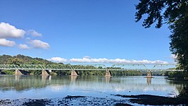 Uhlerstown–Frenchtown Bridge crossing the Delaware River

The Frenchtown Inn was built in 1832 and features Greek Revival architecture. The Frenchtown Station for the Belvidere Delaware Railroad was built c. 1853 and is now the Bridge Cafe. The Nathaniel Shurtz house was built c. 1865 with Italianate style. The Oddfellows Building was built in 1879 with Romanesque Revival architecture.[90]
 Former Frenchtown Station on the Belvidere Delaware Railroad
 Nathaniel Shurtz house
 Oddfellows Building


Education
The Frenchtown School District serves public school students in pre-kindergarten through eighth grade at Edith Ort Thomas Elementary School.[91] As of the 2018–2019 school year, the district, comprised of one school, had an enrollment of 130 students and 18.2 classroom teachers (on an FTE basis), for a student–teacher ratio of 7.1:1.[92] In the 2016–2017 school year, Frenchtown was tied for the 18th-smallest enrollment of any school district in the state, with 129 students.[93]
Public school students in ninth through twelfth grades attend the Delaware Valley Regional High School in Frenchtown, which serves students in western Hunterdon County from Alexandria, Holland and Kingwood Townships along with the boroughs of Frenchtown and Milford.[94][95][96][97] As of the 2018–2019 school year, the high school had an enrollment of 721 students and 68.4 classroom teachers (on an FTE basis), for a student–teacher ratio of 10.5:1.[98] The nine seats on the high school district's nine-member board of education are allocated based on population, with one seat allocated to Frenchtown.[99]
Eighth grade students from all of Hunterdon County are eligible to apply to attend the high school programs offered by the Hunterdon County Vocational School District, a county-wide vocational school district that offers career and technical education at its campuses in Raritan Township and at programs sited at local high schools, with no tuition charged to students for attendance.[100]
Transportation

As of May 2010[update], the borough had a total of 10.32 miles (16.61 km) of roadways, of which 7.50 miles (12.07 km) were maintained by the municipality, 2.36 miles (3.80 km) by Hunterdon County and 0.34 miles (0.55 km) by the New Jersey Department of Transportation and 0.12 miles (0.19 km) by the Delaware River Joint Toll Bridge Commission.[101]
Frenchtown is the northern terminus of Route 29,[102] the western terminus of Route 12[103] and the southern terminus of Route 513.[104]
The Uhlerstown–Frenchtown Bridge is a toll-free bridge over the Delaware River, owned and operated by the Delaware River Joint Toll Bridge Commission, connecting New Jersey Route 12 in Frenchtown with Pennsylvania Route 32 in Uhlerstown, located in Tinicum Township, Bucks County, Pennsylvania. Reconstructed in 1931, the bridge is a six-span Warren truss that extends 950 feet (290 m).[105]
Civic events
Frenchtown celebrates a Bastille Day in July with a different theme each year.[106]
Notable people
People who were born in, residents of, or otherwise closely associated with Frenchtown include:
- James Agee (1909–1955), author, editor and poet who lived in Frenchtown (on Second Street in what is now the police station) with second wife Alma from 1938–1939 and wrote Let Us Now Praise Famous Men during that time[107][108]
- Elizabeth Gilbert (born 1969), author of Eat, Pray, Love[109]
- Shea Hembrey (born 1974), conceptual artist[110]
- Lois Hunt (1925–2009), soprano opera singer who toured for decades with baritone Earl Wrightson[111]
- Anne Kursinski (born 1959), top show jumping competitor[112]
- Harvey Spencer Lewis (1883–1939), Rosicrucian author, occultist and mystic[113]
- J. Linus McAtee (1897–1963), thoroughbred horse racing jockey[114]
- Barb Morrison (born 1967), songwriter and record producer[115]
- Billy Pauch (born 1957), race car driver[116]
- Anna Pump (1934–2015), chef, cookbook author, baker, and innkeeper famous for her bakery in The Hamptons, Loaves & Fishes[117]
- Nathanael West (1903–1940), novelist, screenwriter and satirist, author of Miss Lonelyhearts and The Day of the Locust, boarded at the Frenchtown Inn during the 1930s[118]
See also
- Hunterdon Plateau
- National Register of Historic Places listings in Hunterdon County, New Jersey
References
- 2019 Census Gazetteer Files: New Jersey Places, United States Census Bureau. Accessed July 1, 2020.
- US Gazetteer files: 2010, 2000, and 1990, United States Census Bureau. Accessed September 4, 2014.
- 2012 New Jersey Legislative District Data Book, Rutgers University Edward J. Bloustein School of Planning and Public Policy, March 2013, p. 103.
- Council Members, Frenchtown, NJ. Accessed April 25, 2022.
- 2022 New Jersey Mayors Directory, New Jersey Department of Community Affairs. Accessed March 1, 2022.
- List of Departments, Frenchtown, NJ. Accessed April 24, 2022.
- "ArcGIS REST Services Directory". United States Census Bureau. Retrieved October 11, 2022.
- U.S. Geological Survey Geographic Names Information System: Borough of Frenchtown, Geographic Names Information System. Accessed March 5, 2013.
- "Census Population API". United States Census Bureau. Retrieved October 11, 2022.
- GCT-PH1 Population, Housing Units, Area, and Density: 2010 - State -- County Subdivision from the 2010 Census Summary File 1 for New Jersey Archived 2020-02-12 at archive.today, United States Census Bureau. Accessed November 14, 2012.
- Look Up a ZIP Code for Frenchtown, NJ, United States Postal Service. Accessed November 14, 2012.
- Zip Codes, State of New Jersey. Accessed August 21, 2013.
- Area Code Lookup - NPA NXX for Frenchtown, NJ, Area-Codes.com. Accessed February 17, 2015.
- U.S. Census website , United States Census Bureau. Accessed September 4, 2014.
- Geographic Codes Lookup for New Jersey, Missouri Census Data Center. Accessed April 1, 2022.
- US Board on Geographic Names, United States Geological Survey. Accessed September 4, 2014.
- DP-1 - Profile of General Population and Housing Characteristics: 2010 for Frenchtown borough, Hunterdon County, New Jersey Archived 2020-02-12 at archive.today, United States Census Bureau. Accessed November 14, 2012.
- Municipalities Sorted by 2011-2020 Legislative District, New Jersey Department of State. Accessed February 1, 2020.
- Profile of General Demographic Characteristics: 2010 for Frenchtown borough Archived 2014-08-16 at the Wayback Machine, New Jersey Department of Labor and Workforce Development. Accessed November 14, 2012.
- Table 7. Population for the Counties and Municipalities in New Jersey: 1990, 2000 and 2010, New Jersey Department of Labor and Workforce Development, February 2011. Accessed November 14, 2012.
- Snyder, John P. The Story of New Jersey's Civil Boundaries: 1606-1968, Bureau of Geology and Topography; Trenton, New Jersey; 1969. p. 155. Accessed August 21, 2013.
- Uhlerstown-Frenchtown Toll-Supported Bridge, Delaware River Joint Toll Bridge Commission. Accessed February 21, 2020.
- History, Frenchtown Borough. Accessed November 18, 2019.
- Calvin, Claude (1945). The Calvin Families. University of Wisconsin. pp. 47–53, 57–71.
- The Alexandrian Era Archived 2012-10-23 at the Wayback Machine, Frenchtowner.com. Accessed February 20, 2013. "In 1744, James Alexander purchased 10,000 acres in and around Frenchtown NJ. In 1757, William Alexander and two partners planned out the streets and building lots of our village."
- Hutchinson, Viola L. The Origin of New Jersey Place Names, New Jersey Public Library Commission, May 1945. Accessed August 31, 2015.
- Herman, Jennifer New Jersey Encyclopedia, p. 279. State History Publications, 2008. ISBN 9781878592446. Accessed August 31, 2015.
- Friends of the Frenchtown Library. The Growth of Frenchtown.
- Hurricane Diane Delaware River 1955 flood historical websites
- Areas touching Frenchtown, MapIt. Accessed November 18, 2019.
- Map of County Municipalities, Hunterdon County, New Jersey. Accessed November 15, 2019.
- New Jersey Municipal Boundaries, New Jersey Department of Transportation. Accessed November 15, 2019.
- Solar Projects, Con Edison Development. Accessed August 31, 2015.
- Compendium of censuses 1726-1905: together with the tabulated returns of 1905, New Jersey Department of State, 1906. Accessed August 21, 2013.
- Porter, Robert Percival. Preliminary Results as Contained in the Eleventh Census Bulletins: Volume III - 51 to 75, p. 98. United States Census Bureau, 1890. Accessed November 14, 2012.
- Thirteenth Census of the United States, 1910: Population by Counties and Minor Civil Divisions, 1910, 1900, 1890, United States Census Bureau, p. 337. Accessed November 14, 2012.
- Fifteenth Census of the United States : 1930 - Population Volume I, United States Census Bureau, p. 716. Accessed November 14, 2012.
- New Jersey Resident Population by Municipality: 1930 - 1990, Workforce New Jersey Public Information Network. Accessed June 28, 2015.
- Census 2000 Profiles of Demographic / Social / Economic / Housing Characteristics for Frenchtown borough, New Jersey Archived 2015-02-01 at the Wayback Machine, United States Census Bureau. Accessed November 14, 2012.
- DP-1: Profile of General Demographic Characteristics: 2000 - Census 2000 Summary File 1 (SF 1) 100-Percent Data for Frenchtown borough, Hunterdon County, New Jersey Archived 2020-02-12 at archive.today, United States Census Bureau. Accessed November 14, 2012.
- DP03: Selected Economic Characteristics from the 2006-2010 American Community Survey 5-Year Estimates for Frenchtown borough, Hunterdon County, New Jersey Archived 2020-02-12 at archive.today, United States Census Bureau. Accessed June 21, 2012.
- Inventory of Municipal Forms of Government in New Jersey, Rutgers University Center for Government Studies, July 1, 2011. Accessed November 18, 2019.
- Cerra, Michael F. "Forms of Government: Everything You've Always Wanted to Know, But Were Afraid to Ask" Archived 2014-09-24 at the Wayback Machine, New Jersey State League of Municipalities. Accessed November 30, 2014.
- "Forms of Municipal Government in New Jersey", p. 6. Rutgers University Center for Government Studies. Accessed June 3, 2015.
- 2021 Municipal Data Sheet, Frenchtown, NJ. Accessed April 25, 2022.
- Borough of Frenchtown, Hunterdon County, New Jersey. Accessed April 25, 2022.
- 2022 County and Municipal Directory, Hunterdon County, New Jersey. Accessed April 25, 2022.
- November 2, 2021 District Report Hunterdon County Official Results, Hunterdon County, New Jersey, updated November 12, 2021. Accessed January 1, 2022.
- November 3, 2020 District Report Hunterdon County Official Results, Hunterdon County, New Jersey, updated November 20, 2020. Accessed January 1, 2021.
- Hunterdon County District Canvass November 5, 2019, General Election, Hunterdon County, New Jersey, updated November 14, 2019. Accessed January 1, 2020.
- "Elizabeth J. Johnson Suhay", Bucks County Herald, October 28, 2021. Accessed April 25, 2022. "She was elected to Frenchtown Borough Council and was sewer commissioner until resigning due to illness."
- Borough Council Meeting Minutes for January 5, 2022, Borough of Frenchtown. Accessed April 25, 2022. "Elaine Warner moved to nominate Caroline Scutt to the unexpired term on Council. William O'Brien seconded the motion. Ms. Liebtag said she thought Ms. Scutt was a great choice, and that the Council will be lucky to have her back to serve this term. The Mayor called for a roll-call vote. The Mayor and Council approved Ms. Scutt's nomination by unanimous favorable roll call vote."
- Cummins, Emily. "Perfect storm: Write-in beats N.J. mayor by 51 votes", NJ.com, November 4, 2015. Accessed July 10, 2016. "Write-in candidates are typically doomed from the start. Experts say they are generally novices who start late in the game and build up a core following of family, friends and neighbors and can summon up a few dozen votes.... But Republican Brad Myhre, who defeated incumbent Democrat Warren Cooper in the 2015 Frenchtown mayoral race, is not new to politics."
- Posted By Warren Cooper on Aug 28, 2013, Frenchtown, NJ. Accessed July 9, 2014. "On Friday, Aug. 23, Borough Council appointed Jack Opdyke to take the seat left vacant by the resignation of Robb Arent."
- Plan Components Report, New Jersey Redistricting Commission, December 23, 2011. Accessed February 1, 2020.
- 2019 New Jersey Citizen's Guide to Government, New Jersey League of Women Voters. Accessed October 30, 2019.
- Districts by Number for 2011-2020, New Jersey Legislature. Accessed January 6, 2013.
- 2011 New Jersey Citizen's Guide to Government Archived 2013-06-04 at the Wayback Machine, p. 57, New Jersey League of Women Voters. Accessed May 22, 2015.
- "Congressman Malinowski Fights For The Corporate Transparency Act", Tom Malinowski, press release dated October 23, 2019. Accessed January 19, 2022. "My name, Tom Malinowski. My address, 86 Washington Street, Rocky Hill, NJ 08553."
- U.S. Sen. Cory Booker cruises past Republican challenger Rik Mehta in New Jersey, PhillyVoice. Accessed April 30, 2021. "He now owns a home and lives in Newark's Central Ward community."
- Biography of Bob Menendez, United States Senate, January 26, 2015. "Menendez, who started his political career in Union City, moved in September from Paramus to one of Harrison's new apartment buildings near the town's PATH station.."
- Home, sweet home: Bob Menendez back in Hudson County. nj.com. Accessed April 30, 2021. "Booker, Cory A. - (D - NJ) Class II; Menendez, Robert - (D - NJ) Class I"
- Legislative Roster, New Jersey Legislature. Accessed January 11, 2022.
- About the Board of Commissioners, Hunterdon County, New Jersey. Accessed May 1, 2022. "As top governing officials of Hunterdon County, the five Commissioners are chosen by popular vote in the November general elections. The term of office is for two or three years and the current compensation is $16,000 a year, with an extra $1,000 for the Director. One or two of the five members is elected each year."
- Elected and Appointed Officials, Hunterdon County, New Jersey. Accessed May 1, 2022.
- John E. Lanza, Hunterdon County, New Jersey. Accessed May 1, 2022.
- Zachary T. Rich, Hunterdon County, New Jersey. Accessed May 1, 2022.
- Jeff Kuhl, Hunterdon County, New Jersey. Accessed July 8, 2022.
- Susan Soloway, Hunterdon County, New Jersey. Accessed May 1, 2022.
- Shaun C. Van Doren, Hunterdon County, New Jersey. Accessed July 8, 2022.
- Meet the County Board of Chosen Commissioners, Hunterdon County, New Jersey. Accessed May 1, 2022.
- 2022 County Data Sheet, Hunterdon County, New Jersey. Accessed May 1, 2022.
- Clerk Mary H. Melfi, Hunterdon County, New Jersey. Accessed May 1, 2022.
- Clerks, Constitutional Officers Association of New Jersey. Accessed June 21, 2022.
- Frederick W. Brown; Sheriff, Hunterdon County, New Jersey. Accessed May 1, 2022.
- Sheriffs, Constitutional Officers Association of New Jersey. Accessed June 21, 2022.
- Surrogate Susan J. Hoffman, Hunterdon County, New Jersey. Accessed May 1, 2022.
- Surrogates, Constitutional Officers Association of New Jersey. Accessed June 21, 2022.
- 2022 County and Municipal Directory, Hunterdon County, New Jersey. Accessed May 1, 2022.
- Voter Registration Summary - Hunterdon, New Jersey Department of State Division of Elections, March 23, 2011. Accessed November 14, 2012.
- "Presidential General Election Results - November 6, 2012 - Hunterdon County" (PDF). New Jersey Department of Elections. March 15, 2013. Retrieved December 24, 2014.
- "Number of Registered Voters and Ballots Cast - November 6, 2012 - General Election Results - Hunterdon County" (PDF). New Jersey Department of Elections. March 15, 2013. Retrieved December 24, 2014.
- 2008 Presidential General Election Results: Hunterdon County, New Jersey Department of State Division of Elections, December 23, 2008. Accessed November 14, 2012.
- 2004 Presidential Election: Hunterdon County, New Jersey Department of State Division of Elections, December 13, 2004. Accessed November 14, 2012.
- "Governor - Hunterdon County" (PDF). New Jersey Department of Elections. January 29, 2014. Retrieved December 24, 2014.
- "Number of Registered Voters and Ballots Cast - November 5, 2013 - General Election Results - Hunterdon County" (PDF). New Jersey Department of Elections. January 29, 2014. Retrieved December 24, 2014.
- 2009 Governor: Hunterdon County Archived 2012-10-17 at the Wayback Machine, New Jersey Department of State Division of Elections, December 31, 2009. Accessed November 14, 2012.
- "National Register Information System – (#94000438)". National Register of Historic Places. National Park Service. November 2, 2013.
- "New Jersey and National Registers of Historic Places – Hunterdon County" (PDF). New Jersey Department of Environmental Protection – Historic Preservation Office. June 23, 2021. p. 7.
- Fletcher, Ellen (July 1993). "National Register of Historic Places Inventory/Nomination: Frenchtown Historic District". National Park Service. With accompanying 65 photos
- 2019-2020 Public School Directory, Hunterdon County Department of Education. Accessed November 17, 2019.
- District information for Frenchtown Borough School District, National Center for Education Statistics. Accessed April 1, 2020.
- Guion, Payton. "These 43 N.J. school districts have fewer than 200 students", NJ Advance Media for NJ.com, September 2017. Accessed January 30, 2020. "Based on data from the state Department of Education from the last school year and the Census Bureau, NJ Advance Media made a list of the smallest of the small school districts in the state, excluding charter schools and specialty institutions.... 18. Frenchtown Borough (tie); Enrollment: 129; Grades: Pre-K-8; County: Hunterdon; Town population: 1,373"
- Delaware Valley Regional Board of Education District Policy 0110 - Identification, Delaware Valley Regional High School. Accessed May 2, 2020. "Purpose: The Board of Education exists for the purpose of providing a thorough and efficient system of free public education in grades nine through twelve in the Delaware Valley Regional High School District. Composition: The Delaware Valley Regional High School District is comprised of all the area within the municipal boundaries of Alexandria Township, Frenchtown Borough, Holland Township, Kingwood Township, and Milford Borough."
- Delaware Valley Regional School District 2015 Report Card Narrative, New Jersey Department of Education. Accessed June 6, 2016. "The Delaware Valley Regional High School District can be found in the heart of pastoral and beautiful Hunterdon County, New Jersey. The District serves students in grades nine through twelve who reside in the five municipalities that comprise our region: Alexandria Township, Frenchtown Borough, Holland Township, Kingwood Township, and Milford Borough."
- About Us, Delaware Valley Regional High School District. Accessed June 6, 2016. "The Delaware Valley Regional High School District can be found in the heart of pastoral and beautiful Hunterdon County, New Jersey. The District serves students in grades nine through twelve who reside in the five municipalities that comprise our region: Alexandria Township, Frenchtown Borough, Holland Township, Kingwood Township, and Milford Borough."
- Chief School Administrators/Sending Districts, Hunterdon County, New Jersey Superintendent of Schools. Accessed June 6, 2016.
- School data for Delaware Valley Regional High School, National Center for Education Statistics. Accessed April 1, 2020.
- Board of Education Members, Delaware Valley Regional High School. Accessed May 2, 2020.
- Heyboer, Kelly. "How to get your kid a seat in one of N.J.'s hardest-to-get-into high schools", NJ Advance Media for NJ.com, May 2017. Accessed November 18, 2019. "Hunterdon County's vo-tech district has three academies for high-achieving students, all operating in partnerships with local high schools.... The academies are open to all students in the county. Students in the 8th grade are required to submit an application, schedule an interview and take a placement exam."
- Hunterdon County Mileage by Municipality and Jurisdiction, New Jersey Department of Transportation, May 2010. Accessed July 18, 2014.
- Route 29 Straight Line Diagram, New Jersey Department of Transportation updated July 2014. Accessed November 18, 2019.
- Route 12 Straight Line Diagram, New Jersey Department of Transportation updated March 2016. Accessed November 18, 2019.
- County Route 513 Straight Line Diagram, New Jersey Department of Transportation updated November 2012. Accessed November 18, 2019.
- Uhlerstown-Frenchtown Toll-Supported Bridge, Delaware River Joint Toll Bridge Commission. Accessed November 18, 2019. "The Uhlerstown-Frenchtown Toll Supported Bridge carries Bridge Street traffic from Frenchtown, New Jersey to Uherlstown, Tinicum Township in Pennsylvania."
- Frenchtown website
- James Agee (1909-1955) Chronology of his Life and Work, Agee Films. Accessed July 9, 2014. "1938 Spring - Moves to 27 Second Street, Frenchtown, New Jersey."
- Madden, David; and Folks, Jeffrey Jay. Remembering James Agee, p. 66. University of Georgia Press, 1997. ISBN 9780820319131. Accessed April 25, 2016.
- Rich, Motoko. "Eat, Pray, Love. Then What? Get Married.", The New York Times, August 19, 2009. Accessed November 14, 2012. "'It is and isn't a sequel,' Ms. Gilbert said in a telephone interview from near their home in Frenchtown, N.J."
- Corbett, Sara. "One Hundred Artists Rolled Into One Man", The New York Times, December 16, 2011. Accessed August 21, 2013. "Shea Hembrey is tall and lanky with a wispy beard and dark hair that flops boyishly to either side of his face. He was born and reared in rural Arkansas, but these days he lives in the hamlet of Frenchtown, N. J., in the second-story apartment of a well-kept Victorian cottage on a street filled with the same."
- Grimes, William. "Lois Hunt, Half of Popular Operatic Duo, Dies at 84", The New York Times, July 28, 2009. Accessed November 14, 2012. "Lois Hunt, whose operatic lyric soprano blended seamlessly with Earl Wrightson's baritone in a partnership that lasted nearly 40 years and brought the classics of the American musical theater to audiences through concerts, tent musicals and record albums, died Sunday in Manhattan. She was 84 and lived in Frenchtown, N.J."
- Cosdon, Christina K. "Kappler lands 2nd Invitational", St. Petersburg Times, March 30, 2003. Accessed August 12, 2007. "Anne Kursinski, 43, of Frenchtown, N.J., and Eros placed third for $26,000."
- Harvey Spencer Lewis - Introduction. The Global Oneness Commitment. Accessed June 2, 2008.
- Kieran, John. "Sports of the Times; The Golfer on Horseback.", The New York Times, March 23, 1931. Accessed November 14, 2012. "'I'm 32 years old. Be 33 in October. Born Oct. 5, 1898, at a place called Frenchtown in New Jersey, but we moved to Baltimore when I was pretty small.'"
- Staff. "Transgender Today: barb morrison", The New York Times. Accessed April 25, 2016. "record producer from Frenchtown, N.J."
- Staff. "Pauch wins for the 72nd time at NES", The Times of Trenton, April 27, 2009. Accessed July 28, 2009. "Billy Pauch of Frenchtown proved just why he is the all-time leading winner at the New Egypt Speedway."
- Weber, Bruce. "Anna Pump, Chef and Author Famed for Hamptons Store, Dies at 81", The New York Times, October 9, 2015. Accessed October 10, 2015. "She married Detlef Pump, who became a master stonemason, shortly after graduating from school, and they immigrated to the United States in 1960, settling in Frenchtown, N.J. They moved to the Hamptons in the late 1970s, after spending a two-week vacation there."
- Bucks County and the Delaware Valley Alive, Hunter Publishing, 2010.
External links
- Municipal website
- Hunterdon County web page for Frenchtown Borough
- Frenchtown Elementary School
- School Performance Reports for the Frenchtown School District, New Jersey Department of Education
- School Data for the Frenchtown School District, National Center for Education Statistics
- Delaware Valley Regional High School District
- Frenchtown NJ
- Hunterdon Land Trust Alliance
- Frenchtown Business & Professional Association

National Register of Historic Places in Hunterdon County, New Jersey | ||
|---|---|---|
| Districts |
| |
| Places of worship |
| |
| Houses |
| |
| Buildings |
| |
| Structures |
| |
See also: National Register of Historic Places listings in Hunterdon County, New Jersey and List of National Historic Landmarks in New Jersey | ||
Authority control | |
|---|---|
| General | |
| National libraries | |
Другой контент может иметь иную лицензию. Перед использованием материалов сайта WikiSort.org внимательно изучите правила лицензирования конкретных элементов наполнения сайта.
WikiSort.org - проект по пересортировке и дополнению контента Википедии