world.wikisort.org - USA
Deadhorse is an unincorporated community located within the CDP of Prudhoe Bay in North Slope Borough, Alaska, United States, along the North Slope near the Arctic Ocean. The town consists mainly of facilities for the workers and companies that operate at the nearby Prudhoe Bay Oil Field. Deadhorse is accessible via the Dalton Highway from Fairbanks, 495 mi (797 km) south, or Deadhorse Airport. Limited accommodation is also available for tourists.
Deadhorse, Alaska | |
|---|---|
Unincorporated community | |
 Aerial view of Deadhorse, March 2007 | |
 Deadhorse, Alaska Location in the United States of America | |
| Coordinates: 70°12′20″N 148°30′42″W | |
| Country | United States |
| State | Alaska |
| Borough | North Slope |
| Government | |
| • Borough mayor | Harry K. Brower, Jr. |
| • State senator | Donny Olson (D) |
| • State rep. | Josiah Patkotak (I) |
| Elevation | 49 ft (15 m) |
| Time zone | UTC-9 (Alaska (AKST)) |
| • Summer (DST) | UTC-8 (AKDT) |
| GNIS ID | 1866941[1] |
The permanent population is variously listed as being between 25 and 50 residents. Temporary residents (employed by various firms with local interests) can range as high as 3,000.[citation needed]
Companies with facilities in Deadhorse service Prudhoe Bay, nearby oil fields, and the Trans-Alaska Pipeline System (TAPS), which brings oil from Prudhoe Bay to Valdez on the south-central Alaska coast. Facilities in Deadhorse are built entirely on man-made gravel pads and usually consist of pre-fabricated modules shipped to Deadhorse via barge or air cargo.
History
The Prudhoe Bay, Alaska area was developed to house personnel, provide support for drilling operations, and transport oil to the Alaskan pipeline.[2] Prior to 1977, oil seeps (small pores or fissure networks through which liquid petroleum emerges at the surface of the land)[3] on the Arctic coastal plain had caught the attention of the U.S. petroleum interests. The high school is Dead Horse High School.[2] The U.S. Navy drilled for oil between 1944 and 1953 with little success.[2] However, in 1967, after several attempts at drilling for oil, oil company mergers, and competitive bidding for state lease sales, the Prudhoe Bay oil field was discovered.[2]
Sources conflict on the origin of the area's name. The most cited theory appears to be that the area takes its name from a local business prominent in the late 1960s and 1970s, the "Dead Horse Haulers" trucking company. How the trucking company got its name remains in dispute.[4]
Demographics
| Historical population | |||
|---|---|---|---|
| Census | Pop. | %± | |
| 1970 | 163 | — | |
| 1980 | 64 | −60.7% | |
| 1990 | 26 | −59.4% | |
| U.S. Decennial Census[5] | |||
Deadhorse first appeared on the 1970 U.S. Census as an unincorporated village. It was made a census-designated place (CDP) in 1980. It appeared last on the 1990 census. After 2000, it was merged into the Prudhoe Bay CDP.
Tourism and wildlife

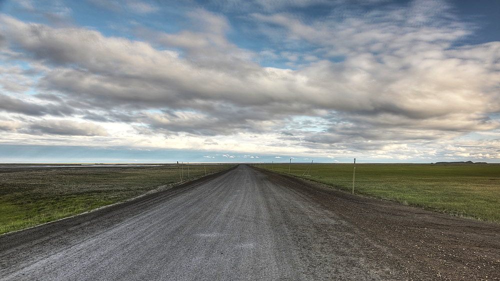
Tourists traveling to Deadhorse and Prudhoe Bay typically take tour buses from Fairbanks via the James Dalton Highway, a two-day journey with an overnight stop in Coldfoot. During the summer months, visitors can arrange for tours to the Arctic Ocean via a guided tour only. There is no longer any public Arctic Ocean access from Deadhorse. All tours must be booked 24 hours in advance to allow time for background checks on all passengers going through the oilfield check point. Tourists can also experience the midnight sun due to Deadhorse's location above the Arctic Circle. In winter, the opposite phenomenon, polar night, occurs.
The area often features large herds of caribou and over 200 bird and waterfowl species, including geese, swans, gulls and eagles.[6] Other indigenous wildlife include Arctic foxes, Arctic ground squirrels, grizzly bears, polar bears, musk oxen, and Arctic hares.[6]
Because alcoholic beverages are not sold in Deadhorse, a humorous slogan for the town is "All that far and still no bar."[7]
The town serves as a start/end or turn-around point of several motorcycle-riding challenges offered by the Iron Butt Association. One of these, the Ultimate Coast to Coast, gives riders 30 days to travel between Deadhorse and Key West (the southernmost city in the contiguous United States) in either direction.[8]
Climate
Like all of the North Slope, Deadhorse features a cold and dry tundra climate (Köppen ET), as even the hottest month, July, has a daily average temperature of only 48 °F (9 °C), although Deadhorse reaches 80 °F (27 °C) on average once every four years, Deadhorse averages four days per year where temperatures reaches at or above 70 °F (21 °C), since 1968 the only years that fail to reach that mark was 1972 and 1980.[9] Precipitation is very light, averaging only 5.70 in (144.8 mm), including only 23.73 in (60.3 cm) of snow – less snowfall than even the warmest places in the Alaska Panhandle like Ketchikan. The mean annual temperature is 14 °F (−10 °C), with maximum temperatures reliably remaining below freezing from early/mid October to late April. As the area is located in USDA Plant Hardiness Zone 2,[10] temperatures below −40 °F (−40 °C) can be expected during the height of winter.
- Longest day: 63 days, 23 hours, 40 minutes (12:09 a.m. on May 20 to 11:18 p.m. on July 22)
- Shortest day: 45 min (11:42 a.m. to 12:27 p.m. on November 24)
- Longest night: 54 days, 22 hours, 51 min (12:27 p.m. on November 24 to 11:18 a.m. on January 18)
- Shortest night: 26 min (11:43 p.m. on May 19 to 12:09 a.m. on May 20)
- Highest recorded temperature: 85 °F (29 °C) on 13 July 2016
- Lowest recorded temperature: −62 °F (−52 °C) on 27 January 1989
- Highest wind speed recorded: 95 knots (109 mph; 176 km/h) on 25 February 1989
- Official lowest wind chill: −102 °F (−74 °C) on 28 January 1989 (air temperature of −54 °F (−48 °C)) and wind speed of 31 kn (36 mph; 57 km/h)
| Climate data for Deadhorse, Alaska | |||||||||||||
|---|---|---|---|---|---|---|---|---|---|---|---|---|---|
| Month | Jan | Feb | Mar | Apr | May | Jun | Jul | Aug | Sep | Oct | Nov | Dec | Year |
| Record high °F (°C) | 40 (4) |
40 (4) |
42 (6) |
43 (6) |
55 (13) |
82 (28) |
85 (29) |
82 (28) |
70 (21) |
50 (10) |
37 (3) |
39 (4) |
85 (29) |
| Mean maximum °F (°C) | 21.2 (−6.0) |
19.5 (−6.9) |
17.0 (−8.3) |
30.9 (−0.6) |
42.3 (5.7) |
69.6 (20.9) |
74.0 (23.3) |
71.2 (21.8) |
59.4 (15.2) |
36.8 (2.7) |
25.0 (−3.9) |
21.9 (−5.6) |
77.1 (25.1) |
| Average high °F (°C) | −8.2 (−22.3) |
−7.7 (−22.1) |
−6.6 (−21.4) |
10.3 (−12.1) |
28.5 (−1.9) |
46.2 (7.9) |
55.1 (12.8) |
49.7 (9.8) |
39.4 (4.1) |
23.9 (−4.5) |
8.3 (−13.2) |
−2.7 (−19.3) |
19.7 (−6.8) |
| Daily mean °F (°C) | −14.5 (−25.8) |
−14.4 (−25.8) |
−13.5 (−25.3) |
3.3 (−15.9) |
24 (−4) |
40.3 (4.6) |
47.8 (8.8) |
43.9 (6.6) |
35.1 (1.7) |
18.8 (−7.3) |
2 (−17) |
−8.9 (−22.7) |
13.7 (−10.2) |
| Average low °F (°C) | −20.8 (−29.3) |
−21.1 (−29.5) |
−20.4 (−29.1) |
−3.8 (−19.9) |
19.5 (−6.9) |
34.3 (1.3) |
40.6 (4.8) |
38.1 (3.4) |
30.8 (−0.7) |
13.7 (−10.2) |
−4.2 (−20.1) |
−15 (−26) |
7.6 (−13.5) |
| Mean minimum °F (°C) | −41.1 (−40.6) |
−42.0 (−41.1) |
−41.4 (−40.8) |
−25.6 (−32.0) |
−2.6 (−19.2) |
26.5 (−3.1) |
32.6 (0.3) |
28.9 (−1.7) |
18.1 (−7.7) |
−9.2 (−22.9) |
−22.7 (−30.4) |
−37.7 (−38.7) |
−46.4 (−43.6) |
| Record low °F (°C) | −62 (−52) |
−57 (−49) |
−54 (−48) |
−47 (−44) |
−19 (−28) |
18 (−8) |
28 (−2) |
23 (−5) |
1 (−17) |
−30 (−34) |
−45 (−43) |
−52 (−47) |
−62 (−52) |
| Average precipitation inches (mm) | 0.25 (6.4) |
0.13 (3.3) |
0.14 (3.6) |
0.21 (5.3) |
0.30 (7.6) |
0.57 (14) |
1.00 (25) |
1.37 (35) |
0.64 (16) |
0.40 (10) |
0.33 (8.4) |
0.36 (9.1) |
5.7 (143.7) |
| Average snowfall inches (cm) | 1.42 (3.6) |
2.09 (5.3) |
0.98 (2.5) |
0.79 (2.0) |
2.21 (5.6) |
0.79 (2.0) |
0.0 (0.0) |
0.12 (0.30) |
3.11 (7.9) |
8.12 (20.6) |
2.01 (5.1) |
2.09 (5.3) |
23.73 (60.2) |
| Source 1: Weather Atlas[11] | |||||||||||||
| Source 2: NOAA (temperature normals 1991–2020),[12] weather.com (precipitation and extremes)[13] | |||||||||||||
Health care
Deadhorse (including Prudhoe Bay) is classified as an isolated town/Sub-Regional Center. It is found in EMS Region 6A in the North Slope Region. Emergency Services have limited highway, coastal, and airport access. Emergency service is provided by paid EMS service and Fairweather Deadhorse Medical Clinic. Auxiliary health care is provided by oil company medical staff and the Greater Prudhoe Bay Fire Dept. Individuals requiring hospital care are usually transported to the nearest hospital/medical center, Sammuel Simmonds Memorial Hospital, in Barrow, Alaska. Because no roads connect Deadhorse to Barrow, individuals are transported by plane or helicopter (an approximately 45 minute flight).[14]
In popular culture
Comic books
- A highly fictionalized version of Deadhorse, AK appears in the Deadhorse comic book series, by Eric Grissom, Phil Sloan, Marissa Louise, and David Halvorson.[15][16]
Television
- Deadhorse is the subject of the second episode of America's Toughest Jobs
- Deadhorse is featured on the third through sixth seasons of Ice Road Truckers, a reality television series airing on the History Channel;[17] it dramatizes trucking on the Dalton Highway and often features truckers transporting equipment to the oil companies located in or around the Prudhoe Bay area.[17]
- It is briefly featured in the first, second, and third seasons of the BBC's Life Below Zero.
- It is featured in the first episode of the BBC's World's Most Dangerous Roads
- It is featured in the X-Files, season 2, episode 17: "End Game".
Image gallery
 Sign at General Store, Deadhorse, Alaska (January 2008)
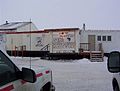 Deadhorse General Store (2003)
 The Dalton Highway at Deadhorse (July 2010)

References
- U.S. Geological Survey Geographic Names Information System: Deadhorse, Alaska
- "Prudhoe Bay - Visit Alaska". Myalaskan.com. 2012-04-17. Archived from the original on 2013-03-15. Retrieved 2013-05-16.
- "oil seep definition of oil seep in the Free Online Encyclopedia". Encyclopedia2.thefreedictionary.com. Retrieved 2013-05-16.
- "How Deadhorse Got Its Name(From the Prudhoe Bay Journal by Deborah Bernard)". www.colvilleinc.com. Archived from the original on July 14, 2020.
- "U.S. Decennial Census". Census.gov. Retrieved June 6, 2013.
- "Deadhorse, Alaska website". Archived from the original on 2022-03-04.
- "Life in Deadhorse, Alaska: It's all about the oil". Independent Record. 2006-08-10. Retrieved 2017-09-11.
- "Ultimate Coast to Coast". Archived from the original on 2013-04-02. Retrieved 2013-05-25.
- @AlaskaWx (August 1, 2021). "High temperature through 4pm AKDT Saturday of 70F at Deadhorse Airport at Prudhoe Bay. This is the tenth day this summer at 70F or higher, the most there in any summer since 1994. The upward trend is significant" (Tweet) – via Twitter.
- The Arbor Day Foundation. "The Arbor Day Foundation". Arborday.org. Retrieved 2013-05-16.
- "Deadhorse AP, Alaska, USA - Monthly weather forecast and Climate data". NOAA. Retrieved 5 May 2021.
- "Station Name: AK DEADHORSE AP". National Oceanic and Atmospheric Administration. Retrieved 2013-03-11.
- "Average weather for Deadhorse". weather.com. Retrieved July 27, 2016.
- "Far North - Prudhoe Bay". Archived from the original on 2014-10-30. Retrieved 2014-10-22. Far North - Prudhoe Bay Information
- Grissom, Eric & Sloan, Phil & Louise, Marissa & Halvorson, David. "Deadhorse". deadhorsecomic.com. Frankenstein's Daughter.
{{cite web}}: CS1 maint: uses authors parameter (link) - Grissom, Eric & Sloan, Phil & Louise, Marissa & Halvorson, David (2013). Dead Birds (Deadhorse #1). Frankenstein's Daughter.
{{cite book}}: CS1 maint: uses authors parameter (link) - "Ice Road Truckers Episode Guide - Season 6". History.com. Archived from the original on 2010-02-09. Retrieved 2013-05-16.
External links
See also
- Dead horse (disambiguation)
Municipalities and communities of North Slope Borough, Alaska, United States | ||
|---|---|---|
Borough seat: Utqiaġvik | ||
| Cities |
|  |
| CDPs | ||
| Unincorporated communities | ||
| Ghost towns | ||
| ||
Authority control | |
|---|---|
| General |
|
| National libraries | |
На других языках
[de] Deadhorse
Deadhorse ist eine Siedlung auf gemeindefreiem Gebiet (Unincorporated Community) am Dalton Highway im US-amerikanischen Bundesstaat Alaska. Deadhorse besteht hauptsächlich aus Unterkünften für die Ölarbeiter im nahegelegenen Prudhoe Bay, dem größten Erdölvorkommen der USA.- [en] Deadhorse, Alaska
[ru] Дедхорс (Аляска)
Дедхорс (англ. Deadhorse — «Мёртвая лошадь») — немуниципальная территория в боро Норт-Слоп, Аляска, США, располагающаяся вдоль Северного склона Аляски, вблизи Северного Ледовитого океана. Город состоит, в основном, из комплекса строений для работников и компаний, которые работают на близлежащих нефтяных месторождениях Прадхо-Бей. В Дедхорс можно попасть по автомагистрали Далтона из Фэрбанкса или через аэропорт Дедхорс. Доступен для ограниченного посещения туристами.Другой контент может иметь иную лицензию. Перед использованием материалов сайта WikiSort.org внимательно изучите правила лицензирования конкретных элементов наполнения сайта.
WikiSort.org - проект по пересортировке и дополнению контента Википедии