world.wikisort.org - USA
Country Club Estates is an unincorporated area and census-designated place (CDP) in Glynn County, Georgia, United States. It is part of the Brunswick, Georgia Metropolitan Statistical Area. The population was 8,373 at the 2020 census,[4] down from 8,545 in 2010.
Country Club Estates, Georgia | |
|---|---|
Census-designated place | |
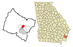 Location in Glynn County and the state of Georgia | |
| Coordinates: 31°12′41″N 81°28′7″W | |
| Country | United States |
| State | Georgia |
| County | Glynn |
| Area | |
| • Total | 4.76 sq mi (12.33 km2) |
| • Land | 4.63 sq mi (11.99 km2) |
| • Water | 0.13 sq mi (0.34 km2) |
| Elevation | 12 ft (4 m) |
| Population (2020) | |
| • Total | 8,373 |
| • Density | 1,808.42/sq mi (698.23/km2) |
| Time zone | UTC-5 (Eastern (EST)) |
| • Summer (DST) | UTC-4 (EDT) |
| FIPS code | 13-19830[2] |
| GNIS feature ID | 1867238[3] |
Geography
Country Club Estates is located at 31°12′41″N 81°28′7″W (31.211438, -81.468663).[5] It is bordered to the south by the city of Brunswick and to the east by the Back River, an arm of the tidal Mackay River. U.S. Route 17 passes through the center of the CDP, leading south 5 miles (8 km) into downtown Brunswick and north 12 miles (19 km) to Darien. The CDP extends north as far as Chapel Crossing Road west of US 17 and Yacht Drive east of US 17.
According to the United States Census Bureau, the CDP has a total area of 4.7 square miles (12.3 km2), of which 4.6 square miles (12.0 km2) is land and 0.1 square miles (0.3 km2), or 2.23%, is water.[6]
Demographics
| Historical population | |||
|---|---|---|---|
| Census | Pop. | %± | |
| 1990 | 7,500 | — | |
| 2000 | 7,594 | 1.3% | |
| 2010 | 8,545 | 12.5% | |
| 2020 | 8,373 | −2.0% | |
| source:[7] | |||
2020 census
| Race | Num. | Perc. |
|---|---|---|
| White (non-Hispanic) | 3,367 | 40.21% |
| Black or African American (non-Hispanic) | 3,636 | 43.43% |
| Native American | 20 | 0.24% |
| Asian | 142 | 1.7% |
| Pacific Islander | 42 | 0.5% |
| Other/Mixed | 318 | 3.8% |
| Hispanic or Latino | 848 | 10.13% |
As of the 2020 United States census, there were 8,373 people, 3,319 households, and 1,869 families residing in the CDP.
2000 census
At the 2000 census there were 7,594 people, 3,134 households, and 2,018 families in the CDP. The population density was 1,600.1 inhabitants per square mile (617.8/km2). There were 3,539 housing units at an average density of 745.7 per square mile (287.9/km2). The racial makup of the CDP was 56.56% White, 38.90% African American, 0.30% Native American, 1.09% Asian, 0.13% Pacific Islander, 1.51% from other races, and 1.50% from two or more races. Hispanic or Latino of any race were 3.34%.[2]
Of the 3,134 households 30.6% had children under the age of 18 living with them, 43.6% were married couples living together, 17.4% had a female householder with no husband present, and 35.6% were non-families. 29.5% of households were one person and 9.2% were one person aged 65 or older. The average household size was 2.42 and the average family size was 3.01.
The age distribution was 26.2% under the age of 18, 10.2% from 18 to 24, 30.2% from 25 to 44, 22.3% from 45 to 64, and 11.1% 65 or older. The median age was 34 years. For every 100 females, there were 91.0 males. For every 100 females age 18 and over, there were 87.2 males.
The median household income was $36,794 and the median family income was $42,359. Males had a median income of $30,621 versus $24,291 for females. The per capita income for the CDP was $18,080. About 10.0% of families and 12.5% of the population were below the poverty line, including 18.0% of those under age 18 and 12.4% of those age 65 or over.
Education
The community's public schools are operated by the Glynn County School System.[8]
Zoned schools serving sections of the CDP include:
- Altama Elementary School (AES) and C. B. Greer Elementary School (GRE)[9]
- Needwood Middle School (NMS) and Jane Macon Middle School (JMS) (small section)[10]
- Brunswick High School (BHS) and Glynn Academy (GA)[11]
References
- "2020 U.S. Gazetteer Files". United States Census Bureau. Retrieved December 18, 2021.
- "U.S. Census website". United States Census Bureau. Retrieved 2008-01-31.
- "US Board on Geographic Names". United States Geological Survey. 2007-10-25. Retrieved 2008-01-31.
- "Explore Census Data". data.census.gov. Retrieved 2021-12-18.
- "US Gazetteer files: 2010, 2000, and 1990". United States Census Bureau. 2011-02-12. Retrieved 2011-04-23.
- "Geographic Identifiers: 2010 Demographic Profile Data (G001): Country Club Estates CDP, Georgia". American Factfinder. U.S. Census Bureau. Retrieved November 22, 2016.[dead link]
- "CENSUS OF POPULATION AND HOUSING (1790-2000)". U.S. Census Bureau. Retrieved 2010-07-30.
- "2010 CENSUS - CENSUS BLOCK MAP: Country Club Estates CDP, GA." U.S. Census Bureau. Retrieved on March 13, 2019.
- "Elementary School Zones Map." Glynn County School System. Retrieved on March 13, 2019.
- "Middle School Zones Map Archived 2019-03-12 at the Wayback Machine." Glynn County School System. Retrieved on March 13, 2019. Detail maps: JMS and NMS.
- "High School Zones Map." Glynn County School System. Retrieved on March 13, 2019.
Municipalities and communities of Glynn County, Georgia, United States | ||
|---|---|---|
County seat: Brunswick | ||
| City | 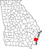 | |
| CDPs |
| |
| Other unincorporated communities | ||
| Ghost towns |
| |
| ||
Authority control | |
|---|---|
| General |
|
| National libraries | |
Другой контент может иметь иную лицензию. Перед использованием материалов сайта WikiSort.org внимательно изучите правила лицензирования конкретных элементов наполнения сайта.
WikiSort.org - проект по пересортировке и дополнению контента Википедии