world.wikisort.org - USA
Darien (/dɛəriˈɛn/) is a city in McIntosh County, Georgia, United States. It lies on Georgia's coast at the mouth of the Altamaha River, approximately 50 miles (80 kilometers) south of Savannah, and is part of the Brunswick, Georgia Metropolitan Statistical Area. The population of Darien was 1,975 at the 2010 census. The city is the county seat of McIntosh County.[4] It is the second oldest planned city in Georgia and was originally called New Inverness.
This article needs additional citations for verification. (April 2017) |
Darien, Georgia | |
|---|---|
City | |
| City of Darien | |
 Darien City Hall | |
 Location in McIntosh County and the state of Georgia | |
| Coordinates: 31°22′16″N 81°25′51″W | |
| Country | United States |
| State | Georgia |
| County | McIntosh |
| Area | |
| • Total | 24.04 sq mi (62.26 km2) |
| • Land | 21.16 sq mi (54.82 km2) |
| • Water | 2.87 sq mi (7.44 km2) |
| Elevation | 30 ft (9 m) |
| Population (2020) | |
| • Total | 1,460 |
| • Density | 68.98/sq mi (26.63/km2) |
| Time zone | UTC-5 (Eastern (EST)) |
| • Summer (DST) | UTC-4 (EDT) |
| ZIP code | 31305 |
| Area code(s) | 912 |
| FIPS code | 13-21716[2] |
| GNIS feature ID | 0331512[3] |
| Website | www |
Geography
Darien is located at 31°22′16″N 81°25′51″W (31.371134, −81.430742).[5]
According to the United States Census Bureau, the city has a total area of 2.0 square miles (5.2 km2), all land.
Demographics
| Historical population | |||
|---|---|---|---|
| Census | Pop. | %± | |
| 1850 | 550 | — | |
| 1860 | 570 | 3.6% | |
| 1870 | 547 | −4.0% | |
| 1880 | 1,543 | 182.1% | |
| 1890 | 1,491 | −3.4% | |
| 1900 | 1,739 | 16.6% | |
| 1910 | 1,391 | −20.0% | |
| 1920 | 823 | −40.8% | |
| 1930 | 937 | 13.9% | |
| 1940 | 1,015 | 8.3% | |
| 1950 | 1,380 | 36.0% | |
| 1960 | 1,569 | 13.7% | |
| 1970 | 1,826 | 16.4% | |
| 1980 | 1,731 | −5.2% | |
| 1990 | 1,783 | 3.0% | |
| 2000 | 1,719 | −3.6% | |
| 2010 | 1,975 | 14.9% | |
| 2020 | 1,460 | −26.1% | |
| U.S. Decennial Census[6] | |||
2020 census
| Race | Num. | Perc. |
|---|---|---|
| White (non-Hispanic) | 810 | 55.48% |
| Black or African American (non-Hispanic) | 542 | 37.12% |
| Native American | 14 | 0.97% |
| Asian | 15 | 1.03% |
| Other/Mixed | 58 | 3.97% |
| Hispanic or Latino | 21 | 1.44% |
As of the 2020 United States census, there were 1,460 people, 957 households, and 609 families residing in the city.
2010 census
As of the 2010 United States Census, there were 1,975 people living in the city. The racial makeup of the city was 51.9% White, 44.1% Black, 0.1% Native American, 0.8% Asian, 0.1% Pacific Islander, 0.1% from some other race and 1.1% from two or more races. 1.9% were Hispanic or Latino of any race.
2000 census
As of the census[2] of 2000, there were 1,719 people, 697 households, and 464 families living in the city. The population density was 869.6/sq mi (335.8/km2). There were 832 housing units at an average density of 420.9/sq mi (162.5/km2). The racial makeup of the city was 54.10% White, 43.98% African American, 0.12% Native American, 0.64% Asian, 0.17% Pacific Islander, 0.06% from other races, and 0.93% from two or more races. Hispanic or Latino of any race were 0.64% of the population.
There were 697 households, out of which 30.6% had children under the age of 18 living with them, 42.8% were married couples living together, 18.8% had a female householder with no husband present, and 33.4% were non-families. 30.6% of all households were made up of individuals, and 13.2% had someone living alone who was 65 years of age or older. The average household size was 2.47 and the average family size was 3.06.
In the city, the population was spread out, with 29.2% under the age of 18, 7.5% from 18 to 24, 25.4% from 25 to 44, 23.5% from 45 to 64, and 14.4% who were 65 years of age or older. The median age was 37 years. For every 100 females, there were 82.5 males. For every 100 females age 18 and over, there were 80.3 males.
The median income for a household in the city was $24,135, and the median income for a family was $28,750. Males had a median income of $26,198 versus $16,897 for females. The per capita income for the city was $11,938. About 21.3% of families and 24.7% of the population were below the poverty line, including 29.8% of those under age 18 and 25.2% of those ages 65 or over.
History
Colonial period

The British built Fort King George in 1721, near what would become Darien. At the time it was the southernmost outpost of the British Empire in North America. The fort was abandoned in 1727 following attacks from the Spanish. Its remains constitute the oldest fort on the Georgia coast.
The town of Darien (originally known as New Inverness) was founded in January 1736 by Scottish Highlanders recruited by James Oglethorpe to act as settler-soldiers protecting the frontiers of Georgia from the Spanish in Florida, the French in the Alabama basin, and the Indian allies of each colonial enterprise. On January 10, 1736, 177 emigrants, including women and children, arrived on the Prince of Wales to establish Darien, which was named after the Darien Scheme, a former Scottish colony in Panama. Among the initial settlers was Lachlan McGillivray, who became a noted trader with the Creek people, and Lachlan McIntosh, a leader during the American Revolutionary War.
The Scots originated mainly from around Inverness and consisted of both Jacobite and Hanoverian supporting clans, the majority of whom spoke only Gaelic. When visited by Oglethorpe in February, the settlers had already constructed "a battery of four pieces of cannon, built a guardhouse, a storehouse, a chapel, and several huts for particular people."[8] Darien was laid out in accordance with the now-famous Oglethorpe Plan.[9]
They showed similar progress in the construction of military forts: by March the Scottish settlers had begun work on two forts, Fort St. Andrews on Cumberland Island,[10] and Fort St. George on the St. Johns River, 60 mi (100 km) to the south of the territory claimed by the British government in the Georgia charter.
In 1736, the British abandoned Fort St. George by agreement with the Spanish officials in Florida. In 1736 Darien settlers began work on Fort Frederica, which is on St. Simons Island, a few miles south of Darien, between it and Cumberland Island. Scots settlers whose travel was paid for by the Trustees of the Colony were organized into two companies, the Highland Independent Company of Foot, an infantry force, and the Highland Rangers, a mounted force. By 1737 the constant military activity of the Darien colony was taking its toll. An additional 44 Highland settlers arrived to expand the town.
Initially the settlers' economy was based on the cultivation of crops; however, after the first year, they suffered a succession of poor harvests. They concentrated on rearing cattle and harvesting timber for sale in nearby Savannah.
In 1739 eighteen of the most prominent members of the Darien colony signed the first petition against the introduction of slavery into Georgia, in response to pleas to Oglethorpe and the trustees by inhabitants of Savannah to lift the prohibition of slavery.[11] The Highlanders' petition was successful, but slavery was introduced ten years later in 1749 because the proprietors could not attract enough laborers to make the colony profitable.
Conflicts continued with Spanish and Indian forces during this time. The War of Jenkins' Ear began in October 1739. In November, in response to two Scots garrisoned on Amelia Island being killed in an ambush by Spanish-allied Indians, the Darien settlers mobilized and, together with forces from South Carolina, captured the Spanish forts of Fort Picolata, Fort San Francisco de Pupo, Fort San Diego, and Fort Mose, before attempting to lay siege to St. Augustine. The Spanish won the Battle of Fort Mose, resulting in the death or capture of 51 Darien settlers.
After the battle, a number of the settlers abandoned Darien for South Carolina. By 1741 another shipload of 43 colonists had arrived. These colonists received land grants from the trustees which specified that the land was to pass to the male or female descendants of the original recipients, in 'Tail General.' The trustees were trying to keep settlers in the colony. Previously, all land grants in the American colonies had been granted in 'Tail Male', descending to only the male children. The Highland settlers objected to the change, as it went against their traditional patrilineal landholding and inheritance practices. In the future, the majority of Georgia land grants were made in 'Tail General'.
In January 1775, the city passed a resolution condemning slavery, saying:
To show the world that we are not influenced by any contracted or interested motives, but a general philanthropy for all mankind, of whatever climate, language, or complexion, we hereby declare our disapprobation and abhorrence of the unnatural practice of Slavery in America, (however the uncultivated state of our country, or other specious arguments may plead for it,) a practice founded in injustice and cruelty, and highly dangerous to our liberties, (as well as our lives,) debasing part of our fellow-creatures below men, and corrupting the virtue and morals of the rest; and is laying the basis of that liberty we contend for (and which we pray the Almighty to continue to the latest posterity) upon a very wrong foundation. We therefore resolve, at all times to use our utmost endevours for the manumission of Slaves...
— Darien Committee, Darien Resolutions, January 12, 1775[12]
Civil War and after


On June 11, 1863, Union troops stationed on St. Simons Island looted and destroyed most of the town, including the homes of black residents, mostly slaves. This was not part of Sherman's March to the Sea, which occurred more than a year later. Confusion has arisen because the St. Simons Island troops were under the command of another General Sherman, stationed in the South Carolina Sea Islands. The destruction of the undefended city, which was of little strategic importance, was carried out by the 54th Massachusetts Volunteers under the command of a reluctant Colonel Robert Gould Shaw and the 2nd South Carolina Volunteers under the command of Colonel James Montgomery. Colonel Montgomery ordered that the town be looted and burned. This was part of the Union strategy to damage the Confederate states' ability to supply food and materiel towards their war effort.[13] Montgomery's troops allegedly broke ranks and looted freely, while Shaw ordered his troops to take only what would be useful at camp. (He later described the raid as a "Satanic action.")[14]
The First African Baptist Church (claimed to be the oldest African American church in the county) was destroyed along with the rest of the town. It was rebuilt, and later some meetings of the 20th-century Civil Rights Movement were held there.
After the U.S. Army destroyed Darien, gunboats were used to blockade the port. The troops plundered residents and plantations of McIntosh County for food, as armies lived off the land to a great extent. The only defenders left in the county were a group of men too old for military service. On the night of August 3, 1864, the county's white defenders had met at the Ebenezer Church, 9 mi (14 km) north of Darien. Union troops found out about the meeting from the local enslaved people. The troops surrounded the church, opened fire, and captured 23 men.[15] These men were marched to a landing near Darien, put on ships, and taken to prisons in the North.[16]
![View of St. Andrews Episcopal Church and Vernon Square in Darien in 1910.[17]](http://upload.wikimedia.org/wikipedia/commons/4/48/General_view_of_Darien.jpg)
Following the Civil War, Darien was rebuilt, with financial aid coming in small part from the family of Colonel Robert Gould Shaw. He had been killed during the war but had written to his family of his shame in participating in the destruction of it.[18]
Into the early 1900s, Darien was one of the largest Southeastern ports for shipping lumber. When the timber was depleted, Darien became a fishing village, known primarily for Georgia wild shrimp. It was once famous for its oysters.
On September 8, 1930, two African American men, George Grant and Willie Bryan, were lynched by a mob of Darien's residents in the Darien Jail due to the death of Police Chief Robert L. Freeman,[19] and the wounding of Deputy Collins and two other officers while trying to capture the two men after a robbery at the Darien Bank. The town was put under martial law by Colonel W.R. Neal of the Georgia militia in response to the mob.[20][21]
There are 32 markers of historic sites near Darien and 42 markers in McIntosh County. (See the external link for a list.)
Darien in the 21st century has shown signs of growth. With the formation of the Interstate Highway System, Interstate 95 was constructed and passes approximately 1 mi (2 km) west of the city. This drew off businesses from the city center as development ensued near the I-95 interchange with GA 251. This has resulted in the building of several chain restaurants, gas stations, and hotels, as well as a small outlet mall. But downtown Darien has flourished with an emphasis on its historic heritage and the waterfront. Many new businesses have opened as the city has reclaimed its walking center.[citation needed]
Government
The city has changed its form of government to council/manager and has hired a city manager.[citation needed]
Education
McIntosh County School District
The McIntosh County School District consists of two elementary schools, a middle school, and a high school. The district has 121 full-time teachers and 1,979 students.[22]
- Todd Grant Elementary School
- McIntosh County Middle School
- McIntosh County Academy
Photos
 Waterfront Park
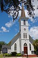 Methodist church
 First African Baptist church
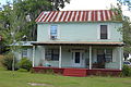 Postbellum house
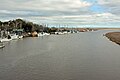 The Darien River. The city of Darien is to the left.


See also
- Vernon Square-Columbus Square Historic District
- West Darien Historic District
References
- "2020 U.S. Gazetteer Files". United States Census Bureau. Retrieved December 18, 2021.
- "U.S. Census website". United States Census Bureau. Retrieved January 31, 2008.
- "US Board on Geographic Names". United States Geological Survey. October 25, 2007. Retrieved January 31, 2008.
- "Find a County". National Association of Counties. Archived from the original on May 31, 2011. Retrieved June 7, 2011.
- "US Gazetteer files: 2010, 2000, and 1990". United States Census Bureau. February 12, 2011. Retrieved April 23, 2011.
- "Census of Population and Housing". Census.gov. Retrieved June 4, 2015.
- "Explore Census Data". data.census.gov. Retrieved December 14, 2021.
- Anthony W. Parker (July 1, 2010). Scottish Highlanders in Colonial Georgia: The Recruitment, Emigration, and Settlement at Darien, 1735-1748. University of Georgia Press. p. 53. ISBN 978-0-8203-2718-1.
- Thomas D. Wilson (February 12, 2015). The Oglethorpe Plan: Enlightenment Design in Savannah and Beyond. University of Virginia Press. p. 109. ISBN 978-0-8139-3711-3.
- Mary R. Bullard (January 1, 2005). Cumberland Island: A History. University of Georgia Press. pp. 30–31. ISBN 978-0-8203-2741-9.
- Jacqueline Jones; Peter Wood; Elaine Tyler May; Thomas Borstelmann; A. Ruiz; Vicki L. Ruiz (February 1, 2005). Created Equal: A Social and Political History of the United States to 1877. Longman Publishing. p. 142. ISBN 978-0-321-31814-5.
- Maria Gehrke (2006). The Revolution of the People: Thoughts and Documents on the Revolutionary Process in North America 1774-1776. Universitätsverlag Göttingen. p. 153. ISBN 978-3-938616-42-0.
- ""Montgomery's Raids in Florida, Georgia, and South Carolina", by William Lee Apthorp, Lt. Colonel, 34th United States Colored Infantry, June 1864".
- "Massachusetts 54th Company A". www.mass54thcompany-a.com. Retrieved November 10, 2015.
- The War of the Rebellion: A Compilation of the Official Records of the Union and Confederate Armies. I. Vol. XXXV. U.S. Government Printing Office. 1891. p. 424.
- "Historical Markers by County - GeorgiaInfo". georgiainfo.galileo.usg.edu. Digital Library of Georgia. 2016. Archived from the original on September 18, 2016. Retrieved July 7, 2017.
- "The Episcopal Community of McIntosh County". standrewsstcyprians.georgiaepiscopal.org. Retrieved April 13, 2017.
- Burchard, Peter. One Gallant Rush, p.151
- ODMP memorial
- "Darien, Georgia Negro Lynchings". New York Times. 2017 Timothy Hughes Rare & Early Newspapers. September 9, 1930. Archived from the original on July 7, 2017. Retrieved July 7, 2017.
- Donald Lee Grant. The Way it was in the South: The Black Experience in Georgia, p.327
- School Stats, Retrieved June 24, 2010.
Further reading
- Burchard, Peter (1965) One Gallant Rush St. Martin's Press, New York, NY;
- Parker, A.W. (1997) Scottish Highlanders in Colonial Georgia, The Recruitment, Emigration and Settlement at Darien, 1735–1748 University of Georgia Press, Athens, GA, ISBN 0-8203-1915-5 ;
- Sullivan, Buddy, ed. The Darien Journal of John Girardeau Legare, Ricegrower (University of Georgia Press; 2010). 168 pages. Journal kept by 1877 migrant from South Carolina, who documents the decline of rice cultivation in tidewater Georgia and the rise of the timber industry.
External links
- Official website of the City of Darien, Georgia
- Georgia's Coast
- Darien, Sherpa Guides
- Fort King George, Georgia State Parks
- Videos of Fort King George "Debatable Lands" Encampment & Battle Reenactment, Lost Worlds
- Historical markers in McIntosh County, Georgia Info
- The burning of Darien
- "McIntosh County Roadside Historical Markers", Georgia Magazine, December 17, 2005
Municipalities and communities of McIntosh County, Georgia, United States | ||
|---|---|---|
County seat: Darien | ||
| City |  | |
| CDPs |
| |
| Other unincorporated communities |
| |
| Ghost town |
| |
| ||
Authority control | |
|---|---|
| General | |
| National libraries | |
| Other |
|
Другой контент может иметь иную лицензию. Перед использованием материалов сайта WikiSort.org внимательно изучите правила лицензирования конкретных элементов наполнения сайта.
WikiSort.org - проект по пересортировке и дополнению контента Википедии