world.wikisort.org - USA
Cottonwood is an unincorporated community in Coal County, Oklahoma, United States.[1] It is located two miles northeast of Coalgate.[2] A post office operated in Cottonwood from April 1, 1914 to December 31, 1914.[2]
Cottonwood, Oklahoma | |
|---|---|
Unincorporated community | |
 Cottonwood Location within the state of Oklahoma  Cottonwood Cottonwood (the United States) | |
| Coordinates: 34°33′21″N 96°12′14″W | |
| Country | United States |
| State | Oklahoma |
| County | Coal |
| Elevation | 604 ft (184 m) |
| Time zone | UTC-6 (Central (CST)) |
| • Summer (DST) | UTC-5 (CDT) |
| GNIS feature ID | 1091706 |
References
- U.S. Geological Survey Geographic Names Information System: Cottonwood, Coal County, Oklahoma
- Shirk, George. Oklahoma Place Names, 2nd ed. University of Oklahoma Press: Norman, Oklahoma. 1987. p.60.
Municipalities and communities of Coal County, Oklahoma, United States | ||
|---|---|---|
County seat: Coalgate | ||
| Cities | 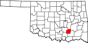 | |
| Towns | ||
| CDPs | ||
| Other communities |
| |
| Indian reservations |
| |
| Footnotes | ‡This populated place also has portions in an adjacent county or counties | |
| ||
This Oklahoma state location article is a stub. You can help Wikipedia by expanding it. |
Текст в блоке "Читать" взят с сайта "Википедия" и доступен по лицензии Creative Commons Attribution-ShareAlike; в отдельных случаях могут действовать дополнительные условия.
Другой контент может иметь иную лицензию. Перед использованием материалов сайта WikiSort.org внимательно изучите правила лицензирования конкретных элементов наполнения сайта.
Другой контент может иметь иную лицензию. Перед использованием материалов сайта WikiSort.org внимательно изучите правила лицензирования конкретных элементов наполнения сайта.
2019-2025
WikiSort.org - проект по пересортировке и дополнению контента Википедии
WikiSort.org - проект по пересортировке и дополнению контента Википедии