world.wikisort.org - USA
Columbia is a town in, and the parish seat of, Caldwell Parish, Louisiana, United States.[2] The population was 390 as of the 2010 census,[3] down from 477 in 2000.
This article needs additional citations for verification. (March 2011) |
Columbia, Louisiana | |
|---|---|
Town | |
| Town of Columbia | |
 Gateway to Ouachita River at Columbia | |
| Nickname(s): Columbia on the Ouachita | |
 Location of Columbia in Caldwell Parish, Louisiana. | |
 Location of Louisiana in the United States | |
| Coordinates: 32°06′15″N 92°04′37″W | |
| Country | United States |
| State | Louisiana |
| Parish | Caldwell |
| Founded | 1827 |
| Area | |
| • Total | 0.77 sq mi (2.00 km2) |
| • Land | 0.76 sq mi (1.98 km2) |
| • Water | 0.01 sq mi (0.02 km2) |
| Elevation | 75 ft (23 m) |
| Population (2020) | |
| • Total | 277 |
| • Rank | CW: 3rd |
| • Density | 362.57/sq mi (139.94/km2) |
| Time zone | UTC-6 (CST) |
| • Summer (DST) | UTC-5 (CDT) |
| ZIP Code | 71418 |
| Area code(s) | 318 |
| FIPS code | 22-16830 |
History
The land that became Columbia was first cleared by Daniel Humphries in 1827. A store was built a few years later the only settlement between Monroe, Louisiana and the settlements of the Black River was formed. The harbor became a busy port for shipping cotton by steamboats and Packet boats until the arrival of the railroad. In February 1864 Columbia was the location of a skirmish between Federal and Confederate troops during the Civil War and there are several plantations in the area.[4]
Geography
Columbia is located just east of the center of Caldwell Parish at 32°6′15″N 92°4′37″W (32.104042, -92.076921),[5] on the southwest bank of the Ouachita River. U.S. Route 165 passes through the center of town and bridges the river, leading north 32 miles (51 km) to Monroe and south 64 miles (103 km) to Alexandria.
According to the United States Census Bureau, the town has a total area of 0.77 square miles (2.00 km2), of which 0.76 square miles (1.96 km2) is land and 0.01 square miles (0.03 km2), or 1.75%, is water.[3]
Demographics
| Historical population | |||
|---|---|---|---|
| Census | Pop. | %± | |
| 1870 | 235 | — | |
| 1880 | 210 | −10.6% | |
| 1890 | 352 | 67.6% | |
| 1900 | 382 | 8.5% | |
| 1910 | 500 | 30.9% | |
| 1920 | 434 | −13.2% | |
| 1930 | 760 | 75.1% | |
| 1940 | 840 | 10.5% | |
| 1950 | 920 | 9.5% | |
| 1960 | 1,021 | 11.0% | |
| 1970 | 1,000 | −2.1% | |
| 1980 | 687 | −31.3% | |
| 1990 | 386 | −43.8% | |
| 2000 | 477 | 23.6% | |
| 2010 | 390 | −18.2% | |
| 2020 | 277 | −29.0% | |
| U.S. Decennial Census[6] | |||
2020 census
| Race | Number | Percentage |
|---|---|---|
| White (non-Hispanic) | 202 | 72.92% |
| Black or African American (non-Hispanic) | 48 | 17.33% |
| Asian | 2 | 0.72% |
| Other/Mixed | 10 | 3.61% |
| Hispanic or Latino | 15 | 5.42% |
As of the 2020 United States census, there were 277 people, 152 households, and 107 families residing in the town.
2000 census
As of the census[8] of 2000, there were 477 people, 184 households, and 101 families residing in the town. The population density was 629.9 people per square mile (242.3/km2). There were 237 housing units at an average density of 312.9 per square mile (120.4/km2). The racial makeup of the town was 70.02% White, 27.25% African American, 0.63% Native American, 1.47% Asian, 0.42% from other races, and 0.21% from two or more races. Hispanic or Latino of any race were 0.42% of the population.
There were 184 households, out of which 21.7% had children under the age of 18 living with them, 40.8% were married couples living together, 12.0% had a female householder with no husband present, and 44.6% were non-families. 41.3% of all households were made up of individuals, and 20.1% had someone living alone who was 65 years of age or older. The average household size was 2.23 and the average family size was 3.08.
In the town, the population was spread out, with 22.2% under the age of 18, 8.4% from 18 to 24, 26.6% from 25 to 44, 24.5% from 45 to 64, and 18.2% who were 65 years of age or older. The median age was 41 years. For every 100 females, there were 103.8 males. For every 100 females age 18 and over, there were 106.1 males.
The median income for a household in the town was $30,000, and the median income for a family was $33,523. Males had a median income of $33,000 versus $18,000 for females. The per capita income for the town was $13,999. About 19.0% of families and 25.9% of the population were below the poverty line, including 32.0% of those under age 18 and 32.0% of those age 65 or over.
Government and infrastructure
Law enforcement services are provided by the Columbia Police Department[9] and the Caldwell Parish Sheriff's Office.[10] Fire protection services are provided by the Columbia Volunteer Fire Department, and by other Volunteer Fire Departments across the parish when needed.[11][12]
Notable people
This section does not cite any sources. (March 2011) |
- Buddy Caldwell, Attorney General of Louisiana, elected in 2007
- Graves B. Erskine, U.S. Marine Corps general; combat officer in World War I, having received the Silver Star and Purple Heart; U.S. Commander of the 3rd Marine Division in World War II in the Battle of Iwo Jima, having earned the Distinguished Service Medal
- J.D. DeBlieux, Louisiana State Senator representing East Baton Rouge Parish, 1956-1960 & 1964-1976
- Pam Kelly, recipient of the Wade Trophy in 1982; the title is awarded to the most valuable women's collegiate basketball player in the nation
- Lelon Kenney, Louisiana state representative, farmer, and businessman
- John J. McKeithen, governor of Louisiana (1964–1972); Louisiana Public Service Commissioner (1955–1964); state representative (1948–1952); U.S. Army combat officer (1942–1945) in the 77th Infantry Division having received two Bronze Stars in the battles of Guam, Leyte, Okinawa and Ie Shima
- W. Fox McKeithen, Louisiana House of Representatives, 1984–1988; five-term Louisiana Secretary of State, 1988–2005; former teacher at Caldwell Parish High School
- Clay Parker, former pitcher for the New York Yankees & Seattle Mariners
- Neil Riser, state senator elected in 2007 from the 32nd District, which includes Caldwell Parish; the first Republican from this district since Reconstruction
- Chet D. Traylor, Louisiana Supreme Court, 1997–2009
Gallery
 Homeland Federal Savings Bank is located off U.S. Highway 165 in Columbia
 A portion of the hillside graves at the large but dispersed Columbia Hill Cemetery in Columbia. The cemetery was launched just prior to the American Civil War during a yellow fever epidemic.
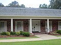 Riser and Son Funeral Home in Columbia is owned by State Senator Neil Riser.
 At this site First United Methodist Church in Columbia dates to 1838. The current building was constructed in 1911. Previously, circuit riders served Caldwell Parish.
 First Baptist Church in Columbia
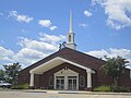 Columbia Heights Baptist Church off Highway 165 calls itself "The Lighthouse on the Hill".


References
- "2020 U.S. Gazetteer Files". United States Census Bureau. Retrieved March 20, 2022.
- "Find a County". National Association of Counties. Archived from the original on 2011-05-31. Retrieved 2011-06-07.
- "Geographic Identifiers: 2010 Demographic Profile Data (G001): Columbia town, Louisiana". U.S. Census Bureau, American Factfinder. Archived from the original on February 12, 2020. Retrieved August 15, 2014.
- Google books: The WPA Guide to Louisiana: The Pelican State; "Columbia"- Retrieved 2017-03-11
- "US Gazetteer files: 2010, 2000, and 1990". United States Census Bureau. 2011-02-12. Retrieved 2011-04-23.
- "Census of Population and Housing". Census.gov. Retrieved June 4, 2015.
- "Explore Census Data". data.census.gov. Retrieved 2021-12-29.
- "U.S. Census website". United States Census Bureau. Retrieved 2008-01-31.
- "Town of Columbia". caldwellparishla. Retrieved 2022-01-27.
- "Caldwell Parish Sheriff's Office". caldwellparishla. Retrieved 2022-01-27.
- "Fire Departments - Caldwell Parish, LA (Fire Stations & Marshals)". www.countyoffice.org. Retrieved 2022-01-27.
- "Fire Services | Caldwell Parish, Louisiana". web.archive.org. 2019-06-21. Archived from the original on 2019-06-21. Retrieved 2022-01-27.
{{cite web}}: CS1 maint: bot: original URL status unknown (link)
External links
- Columbia Progress Community Progress Site for Columbia, LA
Municipalities and communities of Caldwell Parish, Louisiana, United States | ||
|---|---|---|
Parish seat: Columbia | ||
| Town |  | |
| Villages |
| |
| CDP | ||
| Other unincorporated communities |
| |
| ||
На других языках
[de] Columbia (Louisiana)
Columbia ist eine Kleinstadt (mit dem Status „Town“) und Verwaltungssitz des Caldwell Parish im US-amerikanischen Bundesstaat Louisiana. Im Jahr 2010 hatte Columbia 390 Einwohner.[1]- [en] Columbia, Louisiana
Другой контент может иметь иную лицензию. Перед использованием материалов сайта WikiSort.org внимательно изучите правила лицензирования конкретных элементов наполнения сайта.
WikiSort.org - проект по пересортировке и дополнению контента Википедии