world.wikisort.org - USA
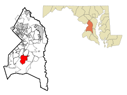
Clinton is an unincorporated census-designated place (CDP) in Prince George's County, Maryland, United States.[2] Clinton was formerly known as Surrattsville until after the time of the Civil War. The population of Clinton was 38,760 at the 2020 census.[3] Clinton is historically known for its role in the American Civil War concerning the Abraham Lincoln assassination. Clinton is adjacent to Camp Springs, Rosaryville, Melwood, and Andrews Air Force Base.
Clinton, Maryland | |
|---|---|
Census-designated place | |
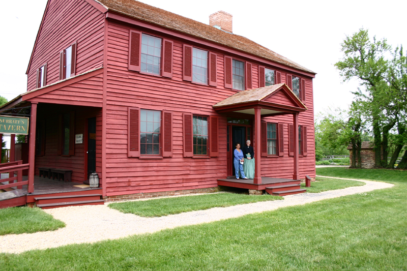 The Surratt House in 2006 | |
 Location of Clinton, Maryland | |
| Coordinates: 38°45′49″N 76°53′44″W | |
| Country | |
| State | |
| County | |
| Area | |
| • Total | 25.09 sq mi (64.99 km2) |
| • Land | 25.02 sq mi (64.79 km2) |
| • Water | 0.08 sq mi (0.20 km2) |
| Elevation | 249 ft (76 m) |
| Population (2020) | |
| • Total | 38,760 |
| • Density | 1,549.35/sq mi (598.21/km2) |
| Time zone | UTC−5 (Eastern (EST)) |
| • Summer (DST) | UTC−4 (EDT) |
| ZIP code | 20735 |
| Area code(s) | 301, 240 |
| FIPS code | 24-17900 |
| GNIS feature ID | 0597253 |
Geography
Clinton is located at 38°45′49″N 76°53′44″W (38.763711, −76.895458).[4] According to the United States Census Bureau, the CDP has a total area of 25.1 square miles (64.9 km2), of which 25.0 square miles (64.7 km2) is land and 0.077 square miles (0.2 km2), or 0.31%, is water.[5]
Demographics
| Historical population | |||
|---|---|---|---|
| Census | Pop. | %± | |
| 1980 | 16,438 | — | |
| 1990 | 19,987 | 21.6% | |
| 2000 | 26,064 | 30.4% | |
| 2010 | 35,970 | 38.0% | |
| 2020 | 38,760 | 7.8% | |
| U.S. Decennial Census[6] 2010[7] 2020[8] | |||
2020 census
| Race / Ethnicity | Pop 2010[7] | Pop 2020[8] | % 2010 | % 2020 |
|---|---|---|---|---|
| White alone (NH) | 3,508 | 2,286 | 9.75% | 5.90% |
| Black or African American alone (NH) | 28,784 | 29,916 | 80.02% | 77.18% |
| Native American or Alaska Native alone (NH) | 103 | 99 | 0.29% | 0.26% |
| Asian alone (NH) | 903 | 958 | 2.51% | 2.47% |
| Pacific Islander alone (NH) | 11 | 9 | 0.03% | 0.02% |
| Some Other Race alone (NH) | 57 | 259 | 0.16% | 0.67% |
| Mixed Race/Multi-Racial (NH) | 739 | 1,258 | 2.05% | 3.25% |
| Hispanic or Latino (any race) | 1,865 | 3,975 | 5.18% | 10.26% |
| Total | 35,970 | 38,760 | 100.00% | 100.00% |
Note: the US Census treats Hispanic/Latino as an ethnic category. This table excludes Latinos from the racial categories and assigns them to a separate category. Hispanics/Latinos can be of any race.
2000 Census
As of the census[9] of 2000, there were 26,064 people, 8,605 households, and 6,772 families residing in the CDP. The population density was 2,208.6 people per square mile (852.8/km2). There were 8,962 housing units at an average density of 759.4 per square mile (293.2/km2). The racial makeup of the CDP was 20.56% white, 73.69% black, 0.47% Native American, 2.47% Asian, 0.02% Pacific Islander, 0.72% from other races, and 2.08% from two or more races. Hispanic or Latino of any race were 1.90% of the population.
There were 8,605 households, out of which 38.5% had children under the age of 18 living with them, 58.8% were married couples living together, 15.2% had a female householder with no husband present, and 21.3% were non-families. 17.4% of all households were made up of individuals, and 5.3% had someone living alone who was 65 years of age or older. The average household size was 2.96 and the average family size was 3.32.
In the CDP, the population was spread out, with 27.2% under the age of 18, 6.7% from 18 to 24, 30.7% from 25 to 44, 26.4% from 45 to 64, and 9.1% who were 65 years of age or older. The median age was 37 years. For every 100 females, there were 89.1 males. For every 100 females age 18 and over, there were 84.8 males.
The median income for a household in the CDP was $71,139, and the median income for a family was $75,036 (these figures had risen to $90,285 and $97,640 respectively as of a 2007 estimate[10]). Males had a median income of $41,736 versus $39,545 for females. The per capita income for the CDP was $24,949. About 2.4% of families and 3.4% of the population were below the poverty line, including 2.5% of those under age 18 and 10.2% of those age 65 or over.
History
Clinton was founded in the 1770s. The town, then named Surratt's Villa, was actually a simple crossroads with a few buildings. In the 1800s, it became known as Surrattsville. The main building served as the post office, an inn and tavern, and a polling place. This main residence was one of two properties owned by the widowed Mary Surratt; the second property was in Washington, D.C.[11]
On 14 and 15 April 1865, John Wilkes Booth, who had two hours earlier assassinated President Abraham Lincoln, stopped by the Surrattsville tavern to pick up weapons and supplies. The U.S. government alleged that Mary Surratt had gone there earlier with these supplies, and was in collusion with the conspirators, one of whom was her son, John Surratt. Because she was found guilty of complicity in the Lincoln assassination, Mary Surratt was hanged at the Capitol Prison in Washington D.C., on 7 July 1865. (Her house is now the Surratt House Museum, with a focus on the assassination.) The U.S. Post Office renamed the town Robeystown, due to the notoriety of the Surratt name, and in keeping with naming towns after the postmaster.[citation needed]
In 1879, Robeystown was renamed Clinton. The local high school, however, retains the name of Surrattsville, and some locals continue, in common usage, to call the town "Surattsville".[citation needed]
The Wyoming house, a historic frame house built in three phases between the 18th and early 19th centuries, is also a part of Clinton's history. The house consists of a main block with gambrel roof (late 18th century), kitchen (c. 1800), and connecting block (c. 1850). The Wyoming house is listed in the Maryland Inventory of Historical Properties and the Historic American Buildings Survey.[12]
In 1913, Blossie Keubeth Miller founded a general store at the town's main intersection. The current commercial property, built in the 1950s, houses a liquor store and is still owned by the Miller family.[13]
Clinton has mostly single-family housing, but includes a few townhouse developments and one retirement mid-rise. Southern Maryland Regional Hospital is in Clinton, as is a private airfield. Louise F. Cosca Regional Park, a public facility operated by the Maryland-National Capital Park and Planning Commission, offers camping, hiking, fishing in a lake, an excellent playground, and a nature museum with nature activities. Clinton boasts a major shopping complex as well, and has a large fringe parking lot nearby where Metro buses take passengers a few miles to the Branch Avenue station of the Washington Metrorail system. Clinton is also home to the James O. Hall Research Center which is located on the premises of the Surratts House.[citation needed]
Major local growth began in the 1950s, spurred partly by the expansion of adjacent Andrews Air Force Base, home of the Air Force Systems Command and the President's plane Air Force One.[citation needed]
Yuri Nosenko a KGB defector, was confined and interrogated at a safehouse in Clinton from April 4, 1964 to August 13, 1965.[14]
A movie titled The Photon Effect was filmed in the town and also in Baltimore. A movie titled Safehouse was filmed in Clinton in 2007. Among the actors who flew out from Los Angeles to act in the film was Luke Barnett, who grew up in Clinton and graduated from Grace Brethren Christian School in 2000.[citation needed]
Clinton is also associated with the 2002 Beltway sniper attacks. A survivor of the attacks was shot in Clinton,[15] while Mildred Muhammad, ex-wife of sniper John Allen Muhammad, was a Clinton resident.[16]
Government and infrastructure
Prince George's County Police Department District 5 Station in Clinton CDP serves the community.[17][18]
The U.S. Postal Service operates the Clinton Post Office.[19]
Education
In the 2016 budget, Clinton schools spent approximately $14,000 per student. [20] By average, there are 18 pupils per teacher, 789 students per librarian, and 431 children per counselor in Clinton (zip 20735), MD schools.[citation needed]
Primary and secondary schools
Prince George's County Public Schools operates public schools serving the census-designated place. The CDP is served by the following schools:[18]
Elementary:[21]
- Clinton Grove Elementary School - in the Clinton CDP
- James Ryder Randall Elementary School - in the Clinton CDP
- Waldon Woods Elementary School - in the Clinton CDP
- Francis T. Evans Elementary School - Adjacent to the Clinton CDP in the Andrews AFB CDP[22][23]
- Melwood Elementary School
- Rose Valley Elementary School
- Tayac Elementary School
Middle:[24]
- Stephen Decatur Middle School - in the Clinton CDP
- James Madison Middle School
- Gwynn Park Middle School
- Isaac J. Gourdine Middle School
High:[25]
- Surrattsville High School - in the Clinton CDP
- Frederick Douglass High School
- Gwynn Park High School
- Dr. Henry A. Wise High School
- Friendly High School
Other:
Private schools
- Clinton Christian School
- Grace Brethren Christian Church and School
- Henson Valley Academy
- Independent Baptist Academy
- Jabez Christian Academy
- Outreach Christian Center Academy
- St. John the Evangelist School
- St. Mary's of Piscataway Catholic School and Church
Public libraries
The Prince George's County Memorial Library System operates the Surratts-Clinton Branch in Clinton.[26]
Notable people
- Luke Barnett, actor known for his Funny or Die episodes
- Tray Chaney, actor in The Wire as "Poot"
- Dante Cunningham, basketball player, power forward for New Orleans Pelicans
- Joe Haden, NFL defensive back
- Marcia Gay Harden, Academy Award-winning actress
- Taraji P. Henson, Golden Globe-winning and Academy Award-nominated actress
- Ty Lawson, basketball player
- Rodney McLeod, NFL defensive back
- Thomas V. Mike Miller, Jr., Maryland State Senate President
- Yuri Nosenko, KGB defector
- Patrick O’Connell, 3-Star Michelin Chef and owner of The Inn at Little Washington
- Claire O'Dell, Lambda Literary Award-winning author
- Chris Rice, CCM singer/songwriter
- Tank, R&B singer
- Delonte West, NBA basketball player
- Brian Westbrook, NFL running back
- Laura Wright, actress
References
- "2020 U.S. Gazetteer Files". United States Census Bureau. Retrieved April 26, 2022.
- U.S. Geological Survey Geographic Names Information System: Clinton, Maryland
- "Clinton CDP, Maryland". United States Census Bureau. Retrieved March 13, 2022.
- "US Gazetteer files: 2010, 2000, and 1990". United States Census Bureau. 2011-02-12. Retrieved 2011-04-23.
- "Geographic Identifiers: 2010 Demographic Profile Data (DP-1): Clinton CDP, Maryland". United States Census Bureau. Retrieved December 18, 2011.
- "Decennial Census of Population and Housing by Decades". US Census Bureau.
- "P2 HISPANIC OR LATINO, AND NOT HISPANIC OR LATINO BY RACE - 2010: DEC Redistricting Data (PL 94-171) - Clinton CDP, Maryland". United States Census Bureau.
- "P2 HISPANIC OR LATINO, AND NOT HISPANIC OR LATINO BY RACE - 2020: DEC Redistricting Data (PL 94-171) - Clinton CDP, Maryland". United States Census Bureau.
- "U.S. Census website". United States Census Bureau. Retrieved 2008-01-31.
- http://factfinder.census.gov/servlet/ACSSAFFFacts?_event=Search&geo_id=16000US1756640&_geoContext=01000US%7C04000US17%7C16000US1756640&_street=&_county=clinton&_cityTown=clinton&_state=04000US24&_zip=&_lang=en&_sse=on&ActiveGeoDiv=geoSelect&_useEV=&pctxt=fph&pgsl=160&_submenuId=factsheet_1&ds_name=ACS_2007_3YR_SAFF&_ci_nbr=null&qr_name=null®=null%3Anull&_keyword=&_industry=%5B%5D
- Diehl, Daniel; Donnelly, Mark P. (1 September 2015). Apparition Atlas: The Ghost Hunter's Travel Guide to Haunted America. Gaia's Essence/Ravenswood Publishing. p. 167. ISBN 978-1-5152-6316-6.
- "Wyoming (Site Number PG:81B-4)" (PDF). Maryland Inventory of HIstoric Properties. Maryland Historical Trust. Retrieved 21 January 2016.
- "B. K. Miller Super Liquors (Site Number PG:81A-21)" (PDF). Maryland Inventory of Historic Properties. Maryland Historical Trust. Retrieved 21 January 2016.
- https://www.cia.gov/readingroom/docs/DOC_0001451843.pdf [bare URL PDF]
- Dao, James (October 22, 2003). "Polite but Dogged, Sniper Suspect Offers Defense". The New York Times. Retrieved 21 January 2016.
- Kiehl, Stephen (November 20, 2003). "Muhammad's ex-wife recalls death threat". The Baltimore Sun. Retrieved 21 January 2016.
- "District 5 Station - Clinton." Prince George's County Police Department. Retrieved on September 9, 2018. " 6707 Groveton Drive Clinton, MD 20735". Beat map.
- "2010 CENSUS - CENSUS BLOCK MAP (INDEX): Clinton CDP, MD." U.S. Census Bureau. Retrieved on August 26, 2018. Pages: 1, 2, 3, 4, 5, and 6. Note the size of the census-designated place was previously smaller. 2000 Index Map: Pages 1, 2, 3, and 4. 1990 Maps of Prince George's County (Index) show Clinton on pages 28, 29, 34, and 35.
- "CLINTON." U.S. Postal Service. Retrieved on September 11, 2018. "9134 PISCATAWAY RD CLINTON, MD 20735-9997"
- Office of Communications (2016). "Facts and Figures". Prince Georges County School System. Retrieved 2017-04-05.
- "NEIGHBORHOOD ELEMENTARY SCHOOLS AND BOUNDARIES SCHOOL YEAR 2018-2019." Prince George's County Public Schools. Retrieved on August 26, 2018.
- "2010 CENSUS - CENSUS BLOCK MAP (INDEX): Andrews AFB CDP, MD." U.S. Census Bureau. Retrieved on September 2, 2018. Pages: 1 and 2.
- "About Our School." Francis T. Evans Elementary School. Retrieved on September 2, 2018. "6720 Old Alexandria Ferry Road, Clinton MD, 20735"
- "NEIGHBORHOOD MIDDLE SCHOOLS AND BOUNDARIES SCHOOL YEAR 2018-2019." Prince George's County Public Schools. Retrieved on August 26, 2018.
- "NEIGHBORHOOD HIGH SCHOOLS AND BOUNDARIES SCHOOL YEAR 2018-2019." Prince George's County Public Schools. Retrieved on August 26, 2018.
- "Surratts-Clinton Branch." Prince George's County Memorial Library System. Retrieved on August 26, 2018.
| Wikimedia Commons has media related to Clinton, Maryland. |
| Wikivoyage has a travel guide for Clinton-Camp Springs. |
Municipalities and communities of Prince George's County, Maryland, United States | ||
|---|---|---|
County seat: Upper Marlboro | ||
| Cities |
|  |
| Towns |
| |
| CDPs |
| |
| Other communities |
| |
| Ghost town | ||
| Footnotes | ‡This populated place also has portions in an adjacent county or counties | |
| ||
Authority control | |
|---|---|
| General |
|
| National libraries | |
| Other |
|
На других языках
- [en] Clinton, Maryland
[ru] Клинтон (Мэриленд)
Клинтон (англ. Clinton) — не имеющий официального органа самоуправления населённый пункт расположенный в округе Принс-Джорджес, штата Мэриленд, США.[3] До гражданской войны в США Клинтон был известен как Сэрраттсвиль (англ. Surrattsville). В 2010 году население было 35 970[4]. Исторически Клинтон известен в связи с убийством Авраама Линкольна. Соседствует с городками Камп Спрингс (англ.), Розаривиль (англ.), Мелвуд (англ.) и авиабазой Эндрюс.Другой контент может иметь иную лицензию. Перед использованием материалов сайта WikiSort.org внимательно изучите правила лицензирования конкретных элементов наполнения сайта.
WikiSort.org - проект по пересортировке и дополнению контента Википедии