world.wikisort.org - USA
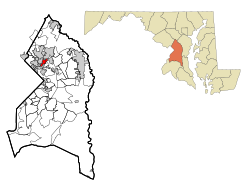
East Riverdale is an unincorporated area and census-designated place (CDP) in Prince George's County, Maryland, United States.[2] The population was 18,459 at the 2020 census.[3]
East Riverdale, Maryland | |
|---|---|
Census-designated place | |
 | |
| Coordinates: 38°57′23″N 76°54′49″W | |
| Country | |
| State | |
| County | |
| Area | |
| • Total | 1.61 sq mi (4.18 km2) |
| • Land | 1.61 sq mi (4.18 km2) |
| • Water | 0.00 sq mi (0.00 km2) |
| Elevation | 36 ft (11 m) |
| Population (2020) | |
| • Total | 18,459 |
| • Density | 11,429.72/sq mi (4,412.22/km2) |
| Time zone | UTC−5 (Eastern (EST)) |
| • Summer (DST) | UTC−4 (EDT) |
| FIPS code | 24-24650 |
| GNIS feature ID | 1714365 |
Geography
East Riverdale is located at 38°57′23″N 76°54′49″W (38.956315, −76.913615).[4]
According to the United States Census Bureau, the CDP has a total area of 1.6 square miles (4.1 km2), all land.
Demographics
| Historical population | |||
|---|---|---|---|
| Census | Pop. | %± | |
| 1970 | 8,941 | — | |
| 1980 | 14,117 | 57.9% | |
| 1990 | 14,187 | 0.5% | |
| 2000 | 14,961 | 5.5% | |
| 2010 | 15,509 | 3.7% | |
| 2020 | 18,459 | 19.0% | |
| U.S. Decennial Census[5] 2010[6] 2020[7] Census area returned as Riverdale Heights-East Pines in 1970. | |||
2020 census
| Race / Ethnicity | Pop 2010[6] | Pop 2020[7] | % 2010 | % 2020 |
|---|---|---|---|---|
| White alone (NH) | 1,323 | 937 | 8.53% | 5.08% |
| Black or African American alone (NH) | 5,198 | 4,229 | 33.52% | 22.91% |
| Native American or Alaska Native alone (NH) | 26 | 17 | 0.17% | 0.09% |
| Asian alone (NH) | 403 | 1,039 | 2.60% | 5.63% |
| Pacific Islander alone (NH) | 5 | 1 | 0.03% | 0.01% |
| Some Other Race alone (NH) | 34 | 101 | 0.22% | 0.55% |
| Mixed Race/Multi-Racial (NH) | 247 | 456 | 1.59% | 2.47% |
| Hispanic or Latino (any race) | 8,273 | 11,679 | 53.34% | 63.27% |
| Total | 15,509 | 18,459 | 100.00% | 100.00% |
Note: the US Census treats Hispanic/Latino as an ethnic category. This table excludes Latinos from the racial categories and assigns them to a separate category. Hispanics/Latinos can be of any race.
2000 Census
As of the census[8] of 2000, there were 14,961 people, 4,538 households, and 3,353 families residing in the CDP. The population density was 9,103.9 people per square mile (3,522.2/km2). There were 4,778 housing units at an average density of 2,907.5/sq mi (1,124.9/km2). The racial makeup of the CDP was 28.71% White, 49.98% African American, 0.59% Native American, 3.71% Asian, 0.14% Pacific Islander, 13.18% from other races, and 3.68% from two or more races. Hispanic or Latino of any race were 26.47% of the population.
There were 4,538 households, out of which 42.4% had children under the age of 18 living with them, 43.9% were married couples living together, 21.4% had a female householder with no husband present, and 26.1% were non-families. 19.9% of all households were made up of individuals, and 4.5% had someone living alone who was 65 years of age or older. The average household size was 3.29 and the average family size was 3.74.
In the CDP, the population was spread out, with 31.1% under the age of 18, 12.0% from 18 to 24, 33.5% from 25 to 44, 17.8% from 45 to 64, and 5.7% who were 65 years of age or older. The median age was 29 years. For every 100 females, there were 102.9 males. For every 100 females age 18 and over, there were 101.6 males.
The median income for a household in the CDP was $45,547, and the median income for a family was $48,918. Males had a median income of $31,807 versus $30,520 for females. The per capita income for the CDP was $15,758. About 11.1% of families and 13.7% of the population were below the poverty line, including 16.0% of those under age 18 and 8.9% of those age 65 or over.
Education
East Riverdale is within the Prince George's County Public Schools system. Schools serving the CDP include:[9]
Elementary schools:[10]
- Berwyn Heights Elementary School
- Bladensburg Elementary School
- Port Towns Elementary School
- Riverdale Elementary School
- Templeton Elementary School
Middle schools:[11]
- William Wirt Middle School
- Charles Carroll Middle School
High schools:[12]
- Bladensburg High School
- Parkdale High School
References
- "2020 U.S. Gazetteer Files". United States Census Bureau. Retrieved April 26, 2022.
- U.S. Geological Survey Geographic Names Information System: East Riverdale, Maryland
- "East Riverdale CDP, Maryland". United States Census Bureau. Retrieved March 13, 2022.
- "US Gazetteer files: 2010, 2000, and 1990". United States Census Bureau. 2011-02-12. Retrieved 2011-04-23.
- "Decennial Census of Population and Housing by Decades". US Census Bureau.
- "P2 HISPANIC OR LATINO, AND NOT HISPANIC OR LATINO BY RACE - 2010: DEC Redistricting Data (PL 94-171) - East Riverdale CDP, Maryland". United States Census Bureau.
- "P2 HISPANIC OR LATINO, AND NOT HISPANIC OR LATINO BY RACE - 2020: DEC Redistricting Data (PL 94-171) - East Riverdale CDP, Maryland". United States Census Bureau.
- "U.S. Census website". United States Census Bureau. Retrieved 2008-01-31.
- "2010 CENSUS - CENSUS BLOCK MAP: East Riverdale CDP, MD." U.S. Census Bureau. Retrieved on August 26, 2018.
- "NEIGHBORHOOD ELEMENTARY SCHOOLS AND BOUNDARIES SCHOOL YEAR 2018-2019." Prince George's County Public Schools. Retrieved on August 26, 2018.
- "NEIGHBORHOOD MIDDLE SCHOOLS AND BOUNDARIES SCHOOL YEAR 2018-2019." Prince George's County Public Schools. Retrieved on August 26, 2018.
- "NEIGHBORHOOD HIGH SCHOOLS AND BOUNDARIES SCHOOL YEAR 2018-2019." Prince George's County Public Schools. Retrieved on August 26, 2018.
| Wikimedia Commons has media related to East Riverdale, Maryland. |
Municipalities and communities of Prince George's County, Maryland, United States | ||
|---|---|---|
County seat: Upper Marlboro | ||
| Cities |
|  |
| Towns |
| |
| CDPs |
| |
| Other communities |
| |
| Ghost town | ||
| Footnotes | ‡This populated place also has portions in an adjacent county or counties | |
| ||
Другой контент может иметь иную лицензию. Перед использованием материалов сайта WikiSort.org внимательно изучите правила лицензирования конкретных элементов наполнения сайта.
WikiSort.org - проект по пересортировке и дополнению контента Википедии