world.wikisort.org - USA
Clarkedale is a town[3] in Crittenden County, Arkansas, United States. Per the 2020 census, the population was 336.[4] Clarkedale incorporated on November 15, 2000.[5]

Clarkedale, Arkansas | |
|---|---|
City | |
 | |
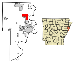 Location of Clarkedale in Crittenden County, Arkansas. | |
 Clarkedale, Arkansas | |
| Coordinates: 35°18′33″N 90°14′10″W | |
| Country | United States |
| State | Arkansas |
| County | Crittenden |
| Area | |
| • Total | 11.44 sq mi (29.62 km2) |
| • Land | 11.44 sq mi (29.62 km2) |
| • Water | 0.00 sq mi (0.00 km2) |
| Elevation | 230 ft (70 m) |
| Population (2020) | |
| • Total | 336 |
| • Density | 29.38/sq mi (11.34/km2) |
| Time zone | UTC-6 (Central (CST)) |
| • Summer (DST) | UTC-5 (CDT) |
| ZIP code | 72325 |
| Area code | 870 |
| FIPS code | 05-14050 |
| GNIS feature ID | 76622[2] |
Demographics
| Historical population | |||
|---|---|---|---|
| Census | Pop. | %± | |
| 2010 | 371 | — | |
| 2020 | 336 | −9.4% | |
| U.S. Decennial Census[6] 2010[7] 2020[8] | |||
2020 census
| Race / Ethnicity | Pop 2010[7] | Pop 2020[8] | % 2010 | % 2020 |
|---|---|---|---|---|
| White alone (NH) | 303 | 276 | 81.67% | 82.14% |
| Black or African American alone (NH) | 50 | 29 | 13.48% | 8.63% |
| Native American or Alaska Native alone (NH) | 3 | 0 | 0.81% | 0.00% |
| Asian alone (NH) | 1 | 0 | 0.27% | 0.00% |
| Pacific Islander alone (NH) | 0 | 0 | 0.00% | 0.00% |
| Some Other Race alone (NH) | 0 | 0 | 0.00% | 0.00% |
| Mixed Race/Multi-Racial (NH) | 2 | 19 | 0.54% | 5.65% |
| Hispanic or Latino (any race) | 12 | 12 | 3.23% | 3.57% |
| Total | 371 | 336 | 100.00% | 100.00% |
Note: the US Census treats Hispanic/Latino as an ethnic category. This table excludes Latinos from the racial categories and assigns them to a separate category. Hispanics/Latinos can be of any race.
Education
Clarkedale is in the Marion School District.[9] Its comprehensive high school is Marion High School.
References
- "2020 U.S. Gazetteer Files". United States Census Bureau. Retrieved October 29, 2021.
- U.S. Geological Survey Geographic Names Information System: Clarkedale, Arkansas
- Local.Arkansas.gov - Clarkedale, retrieved September 3, 2012
- "Clarkedale city, Arkansas". United States Census Bureau. Retrieved April 15, 2022.
- "Boundary Changes". Geographic Change Notes: Arkansas. Population Division, United States Census Bureau. 2010-01-01. Archived from the original on 2012-07-31. Retrieved 2011-06-13.
- "Decennial Census of Population and Housing by Decades". US Census Bureau.
- "P2 HISPANIC OR LATINO, AND NOT HISPANIC OR LATINO BY RACE – 2010: DEC Redistricting Data (PL 94-171) – Clarkedale city, Arkansas". United States Census Bureau.
- "P2 HISPANIC OR LATINO, AND NOT HISPANIC OR LATINO BY RACE – 2020: DEC Redistricting Data (PL 94-171) – Clarkedale city, Arkansas". United States Census Bureau.
- "2020 CENSUS - SCHOOL DISTRICT REFERENCE MAP: Crittenden County, AR" (PDF). U.S. Census Bureau. Retrieved 2022-09-22.
Municipalities and communities of Crittenden County, Arkansas, United States | ||
|---|---|---|
County seat: Marion | ||
| Cities |  | |
| Towns | ||
| Unincorporated communities | ||
| ||
Текст в блоке "Читать" взят с сайта "Википедия" и доступен по лицензии Creative Commons Attribution-ShareAlike; в отдельных случаях могут действовать дополнительные условия.
Другой контент может иметь иную лицензию. Перед использованием материалов сайта WikiSort.org внимательно изучите правила лицензирования конкретных элементов наполнения сайта.
Другой контент может иметь иную лицензию. Перед использованием материалов сайта WikiSort.org внимательно изучите правила лицензирования конкретных элементов наполнения сайта.
2019-2026
WikiSort.org - проект по пересортировке и дополнению контента Википедии
WikiSort.org - проект по пересортировке и дополнению контента Википедии