world.wikisort.org - USA
Clark County is located in the U.S. state of Nevada. As of the 2020 census, the population was 2,265,461. Most of the county population resides in the Las Vegas Census County Divisions, which hold 1,771,945 people as of the 2010 Census, across 476 square miles (1,230 km2).[1] It is by far the most populous county in Nevada, and the 11th most populous county in the United States. It covers 7% of the state's land area but holds 74% of the state's population, making Nevada one of the most centralized states in the United States.
Clark County | |
|---|---|
U.S. county | |
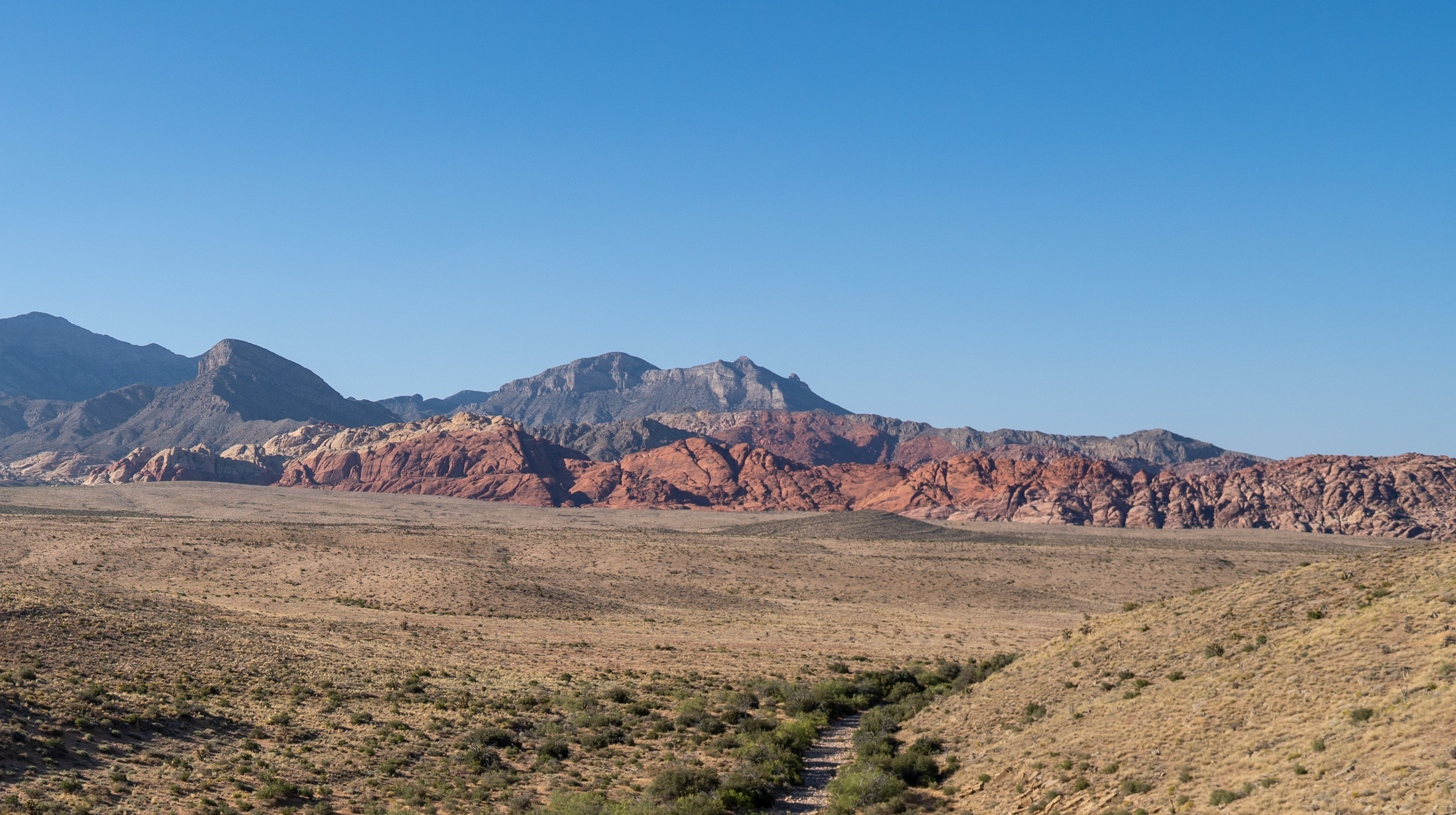
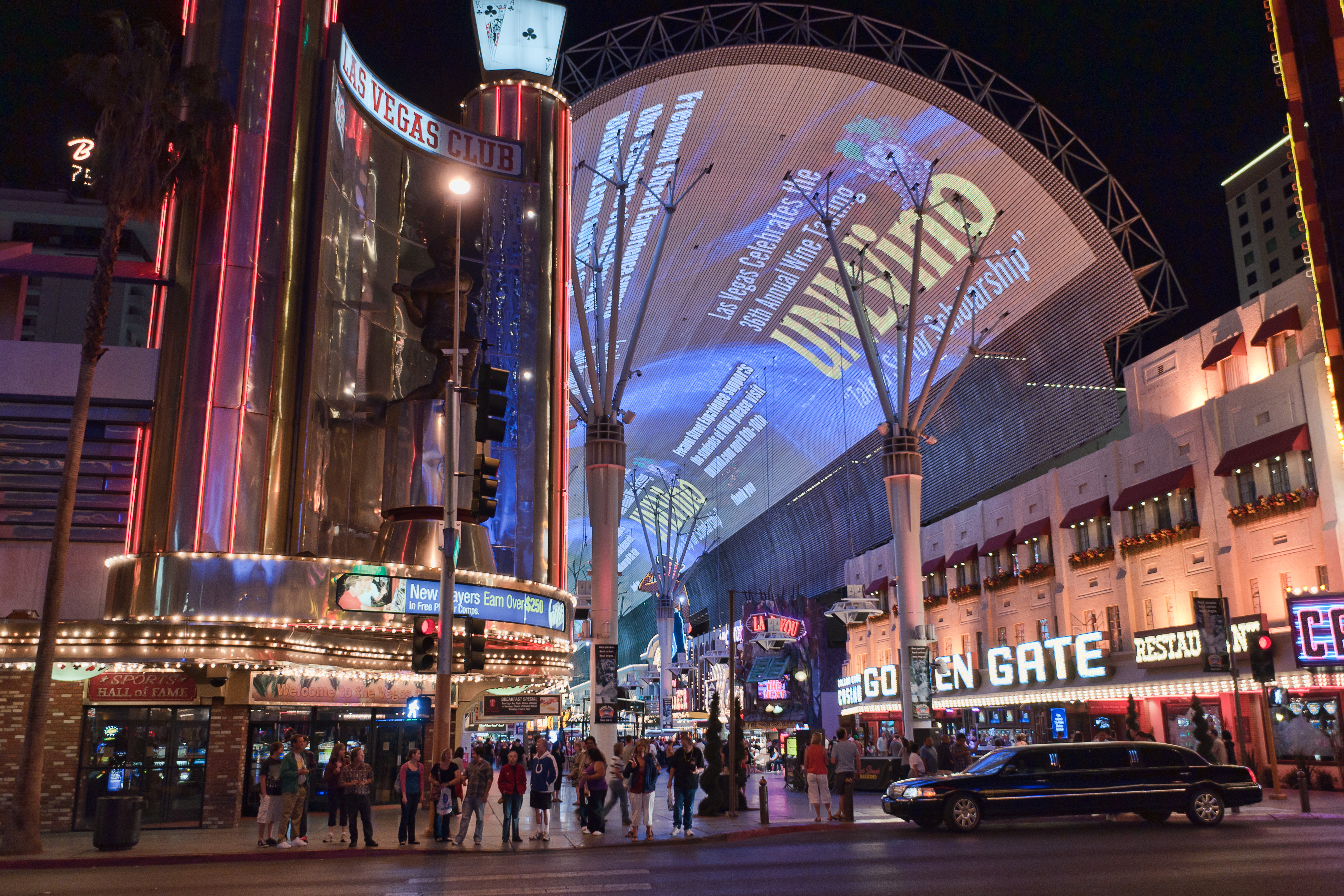
From top, left to right: Caesars Palace panorama, Red Rock Canyon National Conservation Area, Fremont Street Experience, Clark County Government Center, The Venetian, Elephant Rock at Valley of Fire State Park | |
 Seal | |
| Motto(s): "Living Relentlessly, Developing Economically!" | |
 Location within the U.S. state of Nevada | |
 Nevada's location within the U.S. | |
| Coordinates: 36.20°N 115.02°W | |
| Country | |
| State | |
| Founded | January 4, 1909 (founded) July 1, 1909 (organized) |
| Named for | William A. Clark |
| Seat | Las Vegas |
| Largest city | Las Vegas |
| Area | |
| • Total | 8,061 sq mi (20,879 km2) |
| • Land | 7,891 sq mi (20,438 km2) |
| • Water | 170 sq mi (441 km2) 2.1% |
| Population (2020) | |
| • Total | 2,265,461 |
| • Estimate (2021) | 2,292,476 |
| • Density | 290.5/sq mi (112.2/km2) |
| Time zone | UTC−8 (Pacific) |
| • Summer (DST) | UTC−7 (PDT) |
| Congressional districts | 1st, 3rd, 4th |
| Website | http://www.clarkcountynv.gov/ |


History
Las Vegas, the state's most populous city, has been the county seat since its establishment. The county was formed by the Nevada Legislature by splitting off a portion of Lincoln County on February 5, 1909,[2] and was organized on July 1, 1909.[3] The Las Vegas Valley, a 600 sq mi (1,600 km2) basin, includes Las Vegas and other major cities and communities such as North Las Vegas, Henderson, and the unincorporated community of Paradise.
Native Americans lived in the Las Vegas Valley beginning over 10,000 years ago. Paiutes moved into the area as early as AD 700.[4] Previously part of the Mexican Territory of Alta California, the Clark County lands were subsequently traversed by American beaver trappers. Word of their journeys inspired the New Mexican merchant Antonio Armijo in 1829 to establish the first route for mule trains and herds of livestock from Nuevo Mexico to Alta California through the area, along the Virgin and Colorado Rivers. Called the Armijo Route of the Old Spanish Trail, the route was later modified into the Main Route by the passing merchants, trappers, drovers, Ute raiders and settlers over the years by moving to a more direct route. In Clark County it was northward away from the Colorado to a series of creeks, waterholes and springs like those at Las Vegas, to which John C. Frémont added Frémont's Cutoff on his return from California to Utah in 1844.
What is now Clark County was acquired by the United States during the Mexican–American War, becoming part of the northwestern corner of New Mexico Territory. In 1847, Jefferson Hunt and other Mormon Battalion members returning to Salt Lake City from Los Angeles pioneered a wagon route through the County that became the Mormon Road. In 1849, this road became known as the "Southern Route", the winter route of the California Trail from Salt Lake City to Los Angeles during the California Gold Rush. By the mid-1850s, the route now known as the Salt Lake Road in California, and the California Road in Utah Territory, was a wagon trade route between the two. In the mid-1850s, Mormons established a settlement at Las Vegas. In the 1860s, Mormon colonies were established along the Virgin and Muddy Rivers.
All of the county was part of Mohave County, Arizona Territory, when that Territory was formed in 1863, before Nevada became a state. In 1865, it became part of Pah-Ute County, Arizona Territory. The part of Pah-Ute County north and west of the Colorado River was assigned to the new State of Nevada in 1866; however, Arizona territory fought the division until 1871. Pah-Ute County became part of Lincoln County and the westernmost part became the southernmost part of Nye County.
Clark County was named for William A. Clark, a Montana copper magnate and Democratic U.S. Senator.[5] Clark was largely responsible for construction of the San Pedro, Los Angeles and Salt Lake Railroad through the area, contributing to the region's early development. Clark County is a major tourist destination, with 150,000 hotel rooms. The Las Vegas Strip, home to most of the hotel-casinos known to many around the world, is not within the City of Las Vegas limits, but in unincorporated Paradise. It is, however, in the Las Vegas Valley.
Clark County is geographically coextensive with the Las Vegas MSA, a metropolitan statistical area designated by the Office of Management and Budget and used by the United States Census Bureau and other agencies for statistical purposes.[6] Over time and influenced by climate change, droughts in Southern Nevada have been increasing in frequency and severity,[7] putting a further strain on Clark County’s and Las Vegas's water security.
Geography
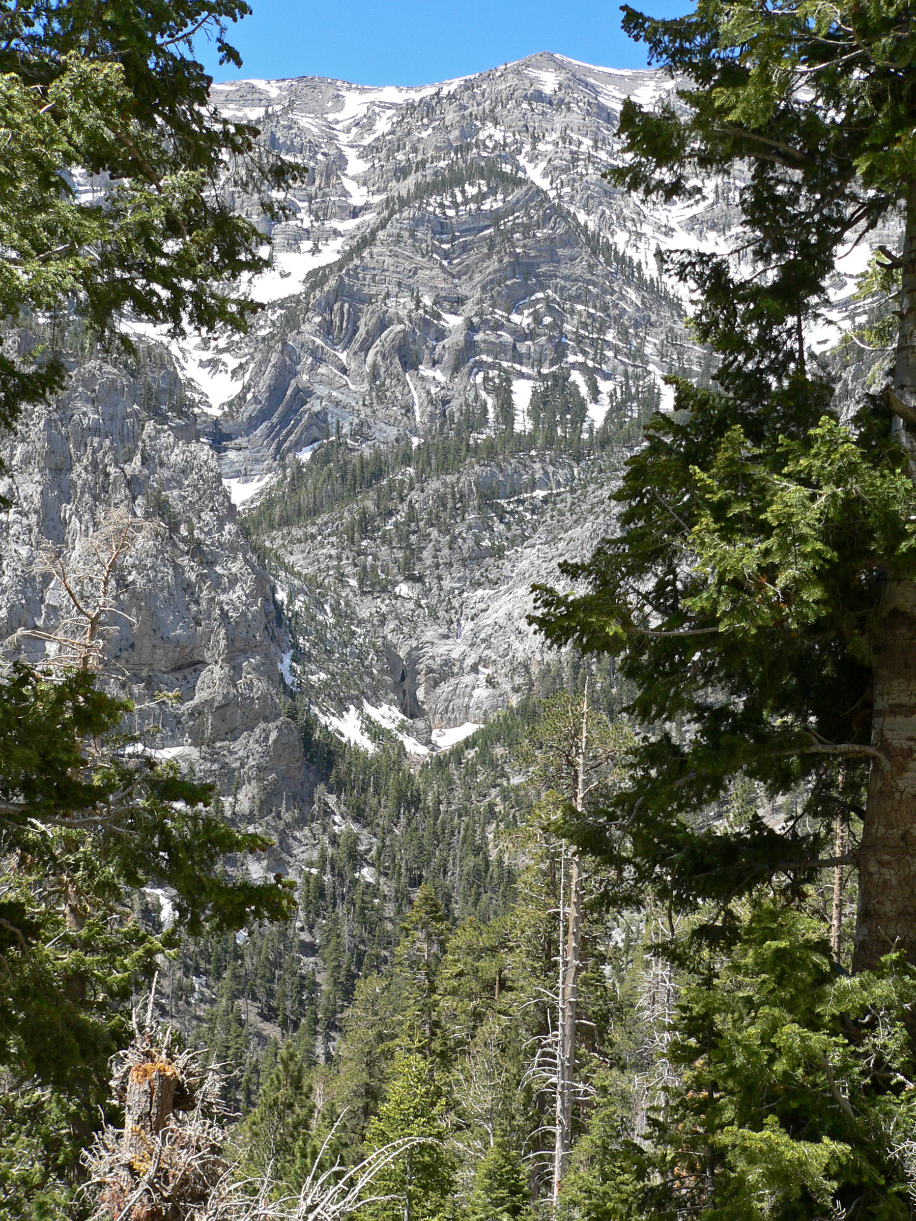
The Colorado River forms the county's southeastern boundary, with Hoover Dam forming Lake Mead along much of its length. The lowest point in the state of Nevada is on the Colorado River just south of Laughlin in Clark County, where it flows out of Nevada into California and Arizona. Greater Las Vegas is a tectonic valley, surrounded by four mountain ranges, with nearby Mount Charleston being the highest elevation at 11,918 ft (3,633 m), located to the northwest. Other than the forests on Mount Charleston, the geography in Clark County is a desert. Creosote bushes are the main native vegetation, and the mountains are mostly rocky with little vegetation.[8] The terrain slopes to the south and east.[9] The county has an area of 20,879 km2 (8,061 sq mi), of which 20,438 km2 (7,891 sq mi) is land and 441 km2 (170 sq mi) (2.1%) is water.[10]
Adjacent counties
- Lincoln County – north
- Mohave County, Arizona – east (observes Mountain Time)
- San Bernardino County, California – south
- Inyo County, California – southwest
- Nye County – west
National protected areas

- Desert National Wildlife Refuge (part)
- Humboldt-Toiyabe National Forest (part)
- Lake Mead National Recreation Area (part)
- Moapa Valley National Wildlife Refuge
- Red Rock Canyon National Conservation Area
- Sloan Canyon National Conservation Area
- Spring Mountains National Recreation Area (part)
- Toiyabe National Forest (part)
- Tule Springs Fossil Beds National Monument (part)
Twenty official wilderness areas in Clark County are part of the National Wilderness Preservation System. Many of these are in, or partially in, one of the preceding protected areas, as shown below. Many are separate entities that are managed by the Bureau of Land Management (BLM):
- Arrow Canyon Wilderness (BLM)
- Black Canyon Wilderness (Nevada) (Lake Mead National Recreational Area [NRA])
- Bridge Canyon Wilderness (Lake Mead NRA)
- Eldorado Wilderness (Lake Mead NRA / BLM)
- Ireteba Peaks Wilderness (Lake Mead NRA / BLM)
- Jimbilnan Wilderness (Lake Mead NRA)
- Jumbo Springs Wilderness (BLM)
- La Madre Mountain Wilderness (BLM / Toiyabe National Forest [NF])
- Lime Canyon Wilderness (BLM)
- Meadow Valley Range Wilderness (BLM) mostly in Lincoln County, Nevada
- Mormon Mountains Wilderness (BLM) mostly in Lincoln County, Nevada
- Mount Charleston Wilderness (Toiyabe NF / BLM)
- Muddy Mountains Wilderness (BLM / Lake Mead NRA)
- Nellis Wash Wilderness (Lake Mead NRA)
- North McCullough Wilderness (part of Sloan Canyon NCA, which is managed by BLM)
- Pinto Valley Wilderness (Lake Mead NRA)
- Rainbow Mountain Wilderness (BLM / Toiyabe NF)
- South McCullough Wilderness (BLM)
- Spirit Mountain Wilderness (Lake Mead NRA / BLM)
- Wee Thump Joshua Tree Wilderness (BLM)
Environmental factors
This section needs additional citations for verification. (June 2009) |
Clark County has diverse desert flora and fauna, including higher-elevation mountain areas, the desert floor, and the Colorado River/Lake Mead ecosystems. Variations in diurnal temperature as well as seasonal swings in temperature create demanding adaptation elements on the species of this county. Population expansion, especially since 1970, has placed additional pressure on species in the area.
Correspondingly, air quality levels prior to the 1960s were in a favorable range, but the proliferation of automobiles with the human population expansion created circumstances where some federal air quality standards were violated starting in the 1980s.[citation needed]
To plan for the wave of development forecast by 1980, Clark County embarked on a regional environmental impact assessment funded by a federal Section 208 program, with Sedway Cooke conducting the planning work and Earth Metrics performing environmental analysis. This endeavor projected population growth, land use changes and environmental impacts.[citation needed]
To prevent the loss of federal funds due to unacceptable dust levels in the Las Vegas valley, in 2003 the Nevada Air Quality Management division (under direction of Clark County officials) created the "Don't Be a Dusthole" campaign. The campaign successfully raised awareness of dust pollution in the Las Vegas valley, quantifiably reducing pollutants and preserving ongoing federal funding.[11]
The Apex Landfill, at 2,200 acres (890 ha), is the nation's largest landfill.[12] Republic Services owns and operates the landfill.
Earthquake hazards
Nevada is the third most seismically active state in the U.S. (after Alaska and California); the United States Geological Survey has estimated that over the next 50 years, Clark County has a 10–20% chance of a M6.0 or greater earthquake occurring within 50 km (31 mi) of Las Vegas.[13]
Demographics
| Historical population | |||
|---|---|---|---|
| Census | Pop. | %± | |
| 1910 | 3,321 | — | |
| 1920 | 4,859 | 46.3% | |
| 1930 | 8,532 | 75.6% | |
| 1940 | 16,414 | 92.4% | |
| 1950 | 48,289 | 194.2% | |
| 1960 | 127,016 | 163.0% | |
| 1970 | 273,288 | 115.2% | |
| 1980 | 463,087 | 69.5% | |
| 1990 | 741,459 | 60.1% | |
| 2000 | 1,375,765 | 85.5% | |
| 2010 | 1,951,269 | 41.8% | |
| 2020 | 2,265,461 | 16.1% | |
| US Decennial Census[14] 1790–1960[15] 1900–1990[16] 1990–2000[17] 2010–2018[18] | |||
![2015 income distribution by household in Las Vegas.[19]](http://upload.wikimedia.org/wikipedia/commons/thumb/8/88/Las_Vegas_household_income_distribution.svg/220px-Las_Vegas_household_income_distribution.svg.png)
![Population living below federal poverty line by census tracts covering Clark County.[20]](http://upload.wikimedia.org/wikipedia/commons/thumb/1/12/Poverty_Las_Vegas_Valley.png/220px-Poverty_Las_Vegas_Valley.png)
| Race / Ethnicity | Pop 2010[21] | Pop 2020[22] | % 2010 | % 2020 |
|---|---|---|---|---|
| White alone (NH) | 935,955 | 892,802 | 47.97% | 39.41% |
| Black or African American alone (NH) | 194,821 | 275,002 | 9.98% | 12.14% |
| Native American or Alaska Native alone (NH) | 8,732 | 8,487 | 0.45% | 0.37% |
| Asian alone (NH) | 165,121 | 231,972 | 8.46% | 10.24% |
| Pacific Islander alone (NH) | 12,474 | 18,877 | 0.64% | 0.83% |
| Some Other Race alone (NH) | 3,719 | 12,890 | 0.19% | 0.57% |
| Mixed Race/Multi-Racial (NH) | 61,803 | 124,015 | 3.17% | 5.48% |
| Hispanic or Latino (any race) | 568,644 | 701,416 | 29.14% | 30.96% |
| Total | 1,951,269 | 2,265,461 | 100.00% | 100.00% |
Note: the US Census treats Hispanic/Latino as an ethnic category. This table excludes Latinos from the racial categories and assigns them to a separate category. Hispanics/Latinos can be of any race.
2000 census
In 2000 there were 512,253 households, out of which 31.7% had children under the age of 18 living with them, 48.7% were married couples living together, 11.8% had a female householder with no husband present, and 33.7% were non-families. 24.5% of all households were made up of individuals, and 6.7% had someone living alone who was above age 64. The average household size was 2.65 and the average family size was 3.17.
The county population contained 25.6% under the age of 18, 9.2% from 18 to 24, 32.2% from 25 to 44, 22.3% from 45 to 64, and 10.7% who were over age 64. The median age was 34 years. For every 100 females there were 103.50 males. For every 100 females age 18 and over, there were 102.80 males.
The median income for a household in the county was $53,536, and the median income for a family was $59,485.[23] Males had a median income of $35,243 versus $27,077 for females. The per capita income for the county was $21,785. About 7.9% of families and 10.8% of the population were below the poverty line, including 14.1% of those under age 18 and 7.3% of those over age 64.
Large numbers of new residents in the state originate from California.[24]
2010 census
As of the 2010 United States Census, there were 1,951,269 people, 715,365 households, and 467,916 families in the county.[25] The population density was 247.3 inhabitants per square mile (95.5/km2). There were 840,343 housing units at an average density of 106.5 per square mile (41.1/km2).[26] The racial makeup of the county was 60.9% White, 13.5% Black or African American, 8.7% Asian, 0.7% Pacific islander, 0.7% American Indian, 10.5% from other races, and 5.1% from two or more races. Those of Hispanic or Latino origin made up 29.1% of the population.[25] In terms of ancestry, 11.7% were German, 9.1% were Irish, 7.6% were English, 6.3% were Italian, and 2.7% were American.[27]
Of the 715,365 households, 34.9% had children under the age of 18 living with them, 45.0% were married couples living together, 13.5% had a female householder with no husband present, 34.6% were non-families, and 25.3% of all households were made up of individuals. The average household size was 2.70 and the average family size was 3.26. The median age was 35.5 years.[25]
The median income for a household in the county was $56,258 and the median income for a family was $63,888. Males had a median income of $43,693 versus $35,324 for females. The per capita income for the county was $27,422. About 8.7% of families and 11.7% of the population were below the poverty line, including 16.9% of those under age 18 and 7.6% of those age 65 or over.[28]
Economy


The county is home to many gaming-related companies. Station Casinos is headquartered in unincorporated Clark County, along with[29][30] Golden Entertainment, American Casino & Entertainment Properties, Bally Technologies, Cannery Casino Resorts, The Majestic Star Casino, LLC, Ameristar Casinos, Archon Corporation, Boyd Gaming, Las Vegas Sands, MGM Resorts International, Wynn Resorts, DBT Online Inc., Two Plus Two Publishing, Gambler's Book Shop / GBC Press, Millennium Management Group, Navegante Group, Pinnacle Entertainment and Tropicana Entertainment.
Largest employers
According to data collected by the Research and Analysis Bureau of the Nevada Department of Employment, Training and Rehabilitation, Clark County's largest employers, both public and private employers, as reported in the fourth quarter of 2012:[31]
30,000 to 39,999 employees
- Clark County School District
5,000 to 10,000 employees
- Clark County government
- Nellis Air Force Base
- Wynn Las Vegas
- Bellagio
- MGM Grand Las Vegas
- Aria Resort & Casino
- Mandalay Bay Resort and Casino
- Caesars Palace
- Las Vegas Metropolitan Police Department
- University of Nevada, Las Vegas
2,500 to 4,999
- The Venetian Las Vegas
- The Mirage
- The Cosmopolitan of Las Vegas
- University Medical Center of Southern Nevada
- The Palazzo
- Encore Las Vegas
- Flamingo Las Vegas
- Southwest Airlines
- City of Las Vegas municipal Government
- Paris Las Vegas
Gaming areas
The State of Nevada divides the state into several gaming districts. Accordingly, the Clark County is divided into the following reporting districts:[32][33]
- Boulder Strip: This region includes 33 casinos on Boulder Highway. Casinos within the Henderson city limits are included as well, such as Green Valley Ranch, Sunset Station, Fiesta, Eldorado, and Jokers Wild.
- Downtown: There are 19 casinos in this reporting area.
- LV Strip: This region is composed of all the casinos on Las Vegas Boulevard, from The Stratosphere at the north end to Mandalay Bay on the south end. Also included are resorts near this area, such as The Rio, South Point, and the Hard Rock; and Harry Reid International Airport (formerly McCarran Airport).
- North Las Vegas: This region has 11 casinos and includes the Fiesta Rancho, Texas Station, Jerry's Nugget, and the Santa Fe Station.
- Laughlin: The casinos in Laughlin.
- Mesquite: The casinos in Mesquite.
- Balance of County: There are 66 casinos[when?] in this category that includes casinos at Lake Las Vegas, Jean, Primm, the Railroad Pass and Hacienda casinos, along with other casinos that don't fit any other category such as Arizona Charlie's Decatur, Gold Coast, The Orleans, The Palms, Suncoast, Rampart, and Red Rock Resort Spa and Casino
Parks and recreation
Government

The Clark County Commission consists of seven members who are elected to serve staggered four-year terms in biennial partisan elections. The commission members elect a chairman, who chairs their meetings. A hired county manager handles day-to-day operations under direction of the commission. The county's unincorporated towns also have appointed boards that provide advice to the commission.
The county operates out of the Clark County Government Center in the City of Las Vegas. The building is unusual in shape, and includes an outdoor amphitheater for concerts and other events.
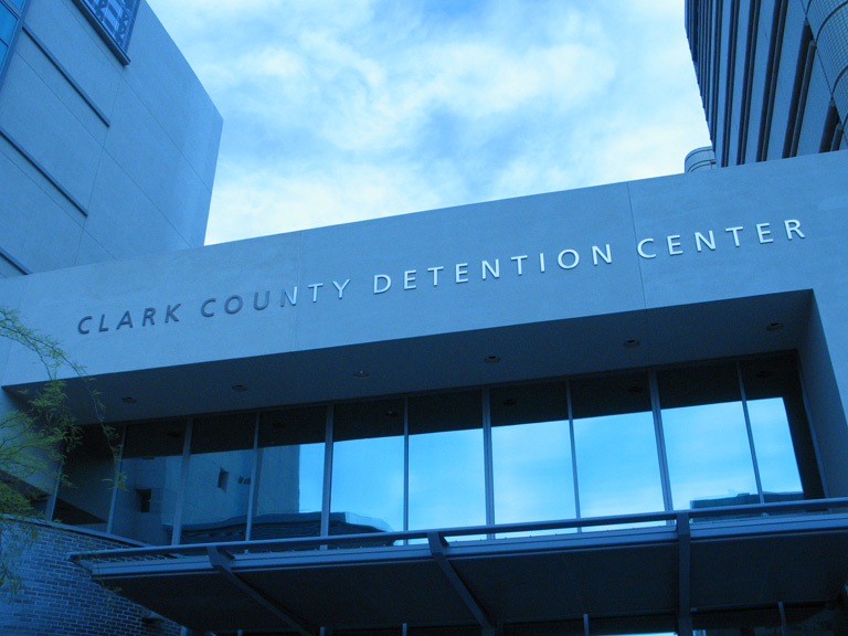
The Las Vegas Metropolitan Police Department provides most law enforcement services in the county, including operation of the county's central jail, the Clark County Detention Center (CCDC). The present department was created in 1973 when the Clark County Sheriff's Department merged with the Las Vegas Police Department.
Other entities with police forces include University of Nevada, Las Vegas, the Clark County School District, and cities such as Henderson, Mesquite, Boulder City and North Las Vegas. The Clark County Park Police is responsible for all of the parks operated by the county and some selected special venues, such as the Clark County Amphitheater, Clark County Archery Range, and the Desert Rose Golf Course.
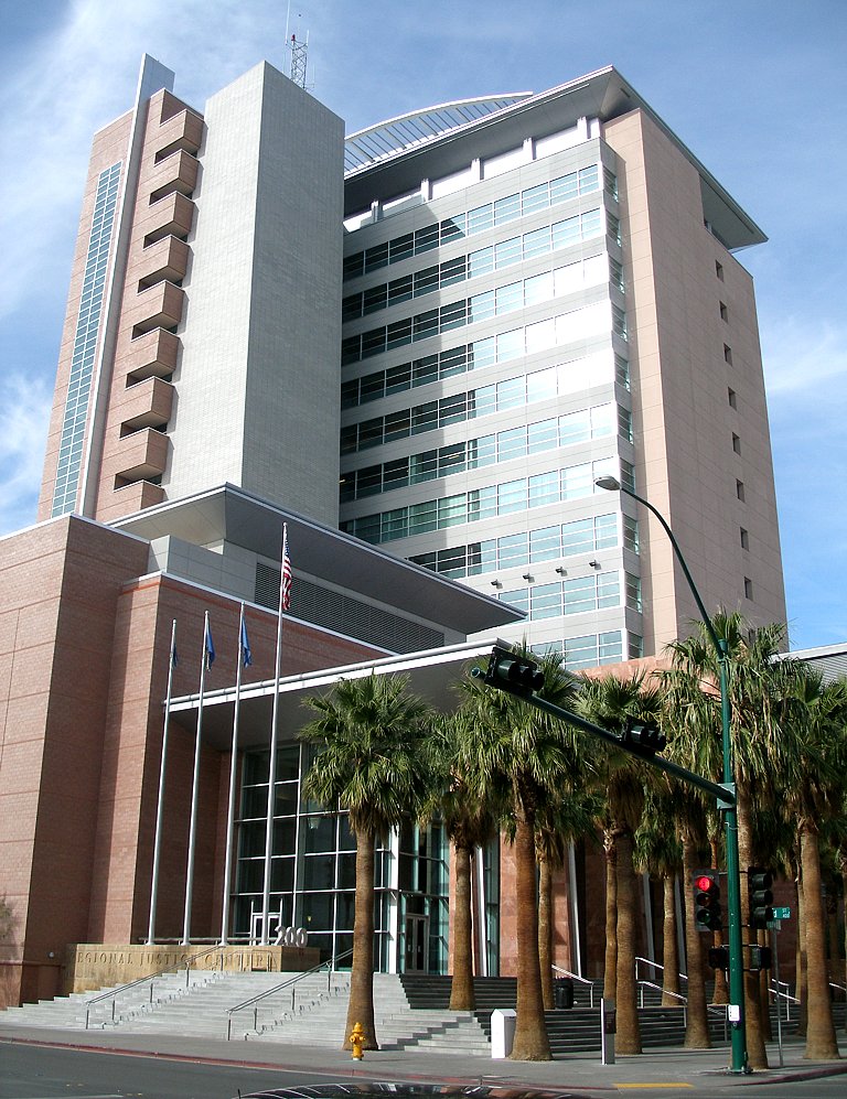
The Regional Justice Center replaced the Clark County Courthouse in 2005, and is about 3 blocks from downtown Fremont Street, at 200 Lewis Avenue.
Courts
The Clark County Justice Courts are divided into eleven townships.[34] Each elects its own justices of the peace for limited jurisdiction cases and a constable.[35] They do not correspond with city boundaries. The Las Vegas Justice Court Township the city of Las Vegas[36][37][38] and the unincorporated towns of Blue Diamond, Cactus Springs, Enterprise, Indian Springs, Mount Charleston, Paradise, Spring Valley, Summerlin South, Sunrise Manor (partially in North Las Vegas Township), Whitney (partially in Henderson Township) and Winchester.[39][36] The city of Las Vegas has a separate municipal court for traffic and criminal misdemeanor offenses that occur within the city's incorporated boundaries.[40]
The Clark County Marshal's Office provides security for Clark County courts. The Marshal is head of the office, while Deputy Marshals act as bailiffs for the court.[41][42]
Voter registration
According to the Secretary of State's office, Democrats comprise a plurality of registered voters in Clark County.
| Clark County Voter Registration Statistics as of September 2022 | |||||
|---|---|---|---|---|---|
| Political Party | Total Voters | Percentage | |||
| Democratic | 563,015 | 35.80% | |||
| Nonpartisan | 483,721 | 30.75% | |||
| Republican | 402,037 | 25.56% | |||
| Independent American | 67,471 | 4.29% | |||
| Libertarian | 13,652 | 0.87% | |||
| Other | 42,979 | 2.73% | |||
| Total | 1,572,875 | 100.00% | |||
Politics

With nearly three-quarters of Nevada's population, Clark County plays a significant role in determining statewide Nevada elections as well the winner of the state's electoral votes in presidential elections. At the presidential level, the county, like most urban counties nationwide, leans Democratic. The last Republican to carry the county was George H. W. Bush in 1988. However, it is somewhat less Democratic than many other urban counties; the GOP candidate has received at least 39 percent of the vote in every election since 1996. This Democratic trend predates the county's explosive growth in the second half of the 20th century. Republican presidential candidates have only won the county six times from 1912 to the present day, all coming in national landslides where the Republican won over 400 electoral votes.
At the statewide level, however, the county is more of a swing county, with several Republican gubernatorial candidates and U.S. Senators winning the county since the late 1980s. The last Republican senator to win the county was John Ensign in his 2006 victory, even as Jim Gibbons lost it in his gubernatorial win over Dina Titus that year. Both Kenny Guinn and Brian Sandoval carried the county in both gubernatorial terms they won, however.
In 2018, Dean Heller carried 15 of Nevada's 17 county-level jurisdictions in his bid for a second full term in the U. S. Senate. Democratic challenger Jacky Rosen won Clark county. In that year's gubernatorial election, Democrat Steve Sisolak lost 15 out of 17 county-level jurisdictions, but won Clark. Since 2008, the Democratic presidential candidate has won Clark by more than enough votes to carry Nevada.
The city of Las Vegas itself leans Democratic, as do the communities of Paradise, Spring Valley and Enterprise. The city of North Las Vegas and the communities of Sunrise Manor, Winchester and Whitney are more strongly Democratic, while the city of Henderson and the Summerlin South community have a Republican lean. Boulder City, where gambling is prohibited, leans Republican. Outside Las Vegas Valley, the county leans Republican.[43][44]
| Year | Republican | Democratic | Third party | |||
|---|---|---|---|---|---|---|
| No. | % | No. | % | No. | % | |
| 2020 | 430,930 | 44.31% | 521,852 | 53.66% | 19,728 | 2.03% |
| 2016 | 320,057 | 41.72% | 402,227 | 52.43% | 44,872 | 5.85% |
| 2012 | 289,053 | 41.82% | 389,936 | 56.42% | 12,201 | 1.77% |
| 2008 | 257,078 | 39.48% | 380,765 | 58.47% | 13,329 | 2.05% |
| 2004 | 255,337 | 46.82% | 281,767 | 51.66% | 8,293 | 1.52% |
| 2000 | 170,932 | 44.72% | 196,100 | 51.31% | 15,166 | 3.97% |
| 1996 | 103,431 | 39.37% | 127,963 | 48.71% | 31,316 | 11.92% |
| 1992 | 97,403 | 32.17% | 124,586 | 41.15% | 80,793 | 26.68% |
| 1988 | 108,110 | 56.37% | 78,359 | 40.86% | 5,310 | 2.77% |
| 1984 | 94,133 | 62.60% | 53,386 | 35.50% | 2,844 | 1.89% |
| 1980 | 76,194 | 59.80% | 38,313 | 30.07% | 12,917 | 10.14% |
| 1976 | 48,236 | 46.92% | 51,178 | 49.78% | 3,398 | 3.31% |
| 1972 | 53,101 | 59.06% | 36,807 | 40.94% | 0 | 0.00% |
| 1968 | 31,522 | 41.99% | 33,225 | 44.26% | 10,318 | 13.75% |
| 1964 | 23,921 | 36.98% | 40,760 | 63.02% | 0 | 0.00% |
| 1960 | 18,197 | 43.18% | 23,949 | 56.82% | 0 | 0.00% |
| 1956 | 18,584 | 49.32% | 19,095 | 50.68% | 0 | 0.00% |
| 1952 | 13,333 | 52.93% | 11,855 | 47.07% | 0 | 0.00% |
| 1948 | 6,382 | 36.57% | 10,787 | 61.81% | 284 | 1.63% |
| 1944 | 4,543 | 38.20% | 7,350 | 61.80% | 0 | 0.00% |
| 1940 | 2,170 | 29.63% | 5,154 | 70.37% | 0 | 0.00% |
| 1936 | 1,178 | 18.79% | 5,091 | 81.21% | 0 | 0.00% |
| 1932 | 1,347 | 18.75% | 5,837 | 81.25% | 0 | 0.00% |
| 1928 | 1,284 | 56.61% | 984 | 43.39% | 0 | 0.00% |
| 1924 | 533 | 32.58% | 288 | 17.60% | 815 | 49.82% |
| 1920 | 589 | 44.62% | 620 | 46.97% | 111 | 8.41% |
| 1916 | 529 | 28.55% | 1,115 | 60.17% | 209 | 11.28% |
| 1912 | 110 | 13.14% | 358 | 42.77% | 369 | 44.09% |
Regional agencies
The Clark County Regional Flood Control District (CCRFCD) was created in 1985 by the Nevada Legislature allowing Clark County to provide broad solutions to flooding problems.
The Regional Transportation Commission of Southern Nevada operates the RTC Transit system, and does planning for most major roadways.
The Southern Nevada Water Authority is a multi-agency group that manages the water distribution for the Las Vegas Valley.
The Las Vegas Wash Coordination Committee manages and protects the Las Vegas Wash.
Since 1999 the group has added more the 15,000 plants to stabilize the wash's banks and restore and expand the wetlands surrounding the wash. As part of the effort to restore the wash to a more natural state, they have removed more than 500,000 pounds (230,000 kg) of trash.
State government
The Grant Sawyer State Office Building, which houses many branches of state government, is within the City of Las Vegas.[46]
The Nevada Department of Corrections operates three prisons within Clark County. High Desert State Prison, a medium-maximum prison, and the Southern Desert Correctional Center, a medium security prison, are both near Indian Springs, Nevada.[47]
The Florence McClure Women's Correctional Center, originally called Southern Nevada Women's Correctional Facility, opened in North Las Vegas on September 1, 1997. It was built and operated by Corrections Corporation of America. On October 1, 2004, the Department of Corrections took direct control of the facility.[48] It houses the female death row.[49]
Education
The Clark County School District serves all of Clark County,[50] with 228 elementary schools, 59 middle schools, and 54 high schools being the fifth largest in the country. Student enrollment in 2014 was 324,093.
Colleges serving the area are University of Nevada, Las Vegas (UNLV), College of Southern Nevada, and Nevada State College.
Transportation
Public transit
Public transit service throughout Clark County is provided by RTC Transit, which is a subsidiary of the Regional Transportation Commission of Southern Nevada. RTC Transit operates The Deuce Bus rapid transit service between Downtown Las Vegas and the Las Vegas Strip.
Major highways
 Interstate 11
 Interstate 15
 Interstate 215
 Interstate 515
 U.S. Route 93
 U.S. Route 93 Business (Boulder City, Nevada)
 U.S. Route 95
- U.S. Route 95 Business (Las Vegas)
 State Route 146
 State Route 147
 State Route 156
 State Route 157
 State Route 158
 State Route 159
 State Route 160
 State Route 161
 State Route 163
 State Route 164
 State Route 165
 State Route 168
 State Route 169
 State Route 170
 State Route 171
 State Route 172
 State Route 173
 State Route 562
 State Route 564
 State Route 573
 State Route 574
 State Route 578
 State Route 579
 State Route 582
 State Route 592
 State Route 593
 State Route 595
 State Route 596
 State Route 599
 State Route 602
 State Route 604
 State Route 610
 State Route 612
 State Route 613
 County Route 215
Rail
- Las Vegas Monorail
Clark County previously had Amtrak service on the Desert Wind, which served Las Vegas Station until it stopped service in 1997. Las Vegas and Laughlin are still served by Amtrak Thruway Motorcoach service which connects to the Southwest Chief.
Resort trams
- Aria Express
- Mandalay Bay Tram
- The Mirage-Treasure Island Tram
Communities
Bracketed number refers to location on map, right
Cities
- Boulder City (21)
- Henderson (19)
- Las Vegas (10) (county seat)
- Mesquite (4)
- North Las Vegas (9)
Census-designated places
- Blue Diamond (18)
- Bunkerville (5)
- Cal-Nev-Ari (23)
- Enterprise (17)
- Goodsprings (20)
- Indian Springs (6)
- Laughlin (24)
- Moapa Town (1)
- Moapa Valley (3)
- Mount Charleston (7)
- Nelson
- Paradise (15)
- Sandy Valley (16)
- Searchlight (22)
- Spring Valley (13)
- Summerlin South (12)
- Sunrise Manor (11)
- Whitney (formerly East Las Vegas) (26)
- Winchester (14)
Air Force bases
Unincorporated communities
- Arden (former CDP)
- Cactus Springs
- Cottonwood Cove
- Coyote Springs (planned)
- Crystal (former CDP)
- Fort Mojave Indian Reservation (former CDP) (25)
- Glendale (former CDP)
- Jean
- Logandale
- Las Vegas Indian Colony (8)
- Moapa River Indian Reservation (2)
- Mountain Springs
- Overton
- Primm
- Roach
- Sloan
- Summerlin
- Sutor[51]
- Vegas Creek (former CDP)
Climate
| ||||||||||||||||||||||||||||||||||||||||||||||||||||||||||||||||||||||||||||||||||||||||||||||||||||||||||||||||||||||||||||
See also
- Clark County Fire Department (Nevada)
- List of airports in Clark County, Nevada
- National Register of Historic Places listings in Clark County, Nevada
References
- "Nevada: 2010, Summary Population and Housing Characteristics; 2010 Census of Population and Housing" (PDF). United States Census Bureau. U.S. Department of Commerce, Economics and Statistics Administration. Retrieved January 9, 2020.
- Las Vegas Sun, January 4, 2009; Joseph Nathan Kane, The American Counties (4th Ed.), (The Scarecrow Press, 1983), pp. 479-480
- Squires, C. P. Sam P. Davis (ed.). The History of Nevada. Nevada's Online State News Journal. p. 801. Archived from the original on July 20, 2009. Retrieved July 25, 2009.
- Moehring, Eugene P.; & Green, Michael S. (2005). Las Vegas: A Centennial History. University of Nevada Press. p. 2. ISBN 0-87417-615-8
- Pitts, Stanley Thomas (May 2006). An Unjust Legacy: A Critical Study of the Political Campaigns of William Andrews Clark, 1888-1901 (PDF). University of North Texas: M.S. thesis. p. 205. Retrieved March 9, 2020.
- "Metropolitan Statistical Areas and Components, December 2005, with codes". Archived from the original on February 9, 2006. Retrieved March 23, 2007.
- "West megadrought worsens to driest in at least 1,200 years". m.lasvegassun.com. February 15, 2022. Retrieved May 27, 2022.
- "Clark County NV Google Maps (accessed 10 February 2019)".
- ""Find an Altitude" Google Maps (accessed 10 February 2019)". Archived from the original on May 21, 2019. Retrieved February 11, 2019.
- "2010 Census Gazetteer Files". US Census Bureau. August 22, 2012. Retrieved December 20, 2014.
- "News – Dusty the Dusthole successful". Reviewjournal.com. Archived from the original on March 24, 2012. Retrieved May 4, 2013.
- Schoenmann, Joe (December 17, 2008). "Official calls for sort reform". Las Vegas Sun. Retrieved December 20, 2008.
- "Loss-Estimation Modeling of Earthquake Scenarios for Each County in Nevada Using HAZUS-MH" (PDF). Nevada Bureau of Mines and Geology. Nevada Bureau of Mines and Geology/University of Nevada, Reno. February 23, 2006. Retrieved March 27, 2016.
"Probability of an earthquake of magnitude 6.0 or greater occurring within 50 km in 50 years (from USGS probabilistic seismic hazard analysis) 10–20% chance for Las Vegas area, magnitude 6" (p. 65)
- "US Decennial Census". US Census Bureau. Retrieved December 20, 2014.
- "Historical Census Browser". University of Virginia Library. Retrieved December 20, 2014.
- "Population of Counties by Decennial Census: 1900 to 1990". US Census Bureau. Retrieved December 20, 2014.
- "Census 2000 PHC-T-4. Ranking Tables for Counties: 1990 and 2000" (PDF). US Census Bureau. Retrieved December 20, 2014.
- "American Factfinder". United States Census Bureau. Archived from the original on February 13, 2020. Retrieved April 24, 2018.
- "Household Income Distribution in Las Vegas". United States Census Bureau. US Census Breau. Retrieved May 4, 2018.
- "Poverty Status in the Past 12 Months". American Fact Finder. US Census Breau. Archived from the original on February 14, 2020. Retrieved April 9, 2018.
- "P2 HISPANIC OR LATINO, AND NOT HISPANIC OR LATINO BY RACE - 2010: DEC Redistricting Data (PL 94-171) - Clark County, Nevada". United States Census Bureau.
- "P2 HISPANIC OR LATINO, AND NOT HISPANIC OR LATINO BY RACE - 2020: DEC Redistricting Data (PL 94-171) - Clark County, Nevada". United States Census Bureau.
- "Clark County, Nevada – Income in the Past 12 Months (In 2006 Inflation-Adjusted Dollars)". Factfinder.census.gov. Archived from the original on February 14, 2020. Retrieved May 4, 2013.
- "About.com". Usgovinfo.about.com. June 19, 2010. Retrieved February 20, 2011.
- "Profile of General Population and Housing Characteristics: 2010 Demographic Profile Data". US Census Bureau. Archived from the original on February 13, 2020. Retrieved January 21, 2016.
- "Population, Housing Units, Area, and Density: 2010 – County". US Census Bureau. Archived from the original on February 13, 2020. Retrieved January 21, 2016.
- "Selected Social Characteristics in the US – 2006–2010 American Community Survey 5-Year Estimates". US Census Bureau. Archived from the original on February 13, 2020. Retrieved January 21, 2016.
- "Selected Economic Characteristics – 2006–2010 American Community Survey 5-Year Estimates". US Census Bureau. Archived from the original on February 13, 2020. Retrieved January 21, 2016.
- "Interactive Map Viewer Archived January 2, 2016, at the Wayback Machine." City of Las Vegas. Retrieved on June 5, 2009.
- "Map." Station Casinos. Retrieved on June 5, 2009. Archived September 5, 2015, at the Wayback Machine
- "Nevada Workforce Informer, Nevada's Top Employers". Nevadaworkforce.com. Retrieved January 1, 2016.
- "Abbreviated Revenue Release Index". Nevada Gaming Control Board. Archived from the original on August 20, 2008. Retrieved May 3, 2009.
- "February 2009 Nevada Gaming Revenues and Collections" (PDF). Nevada Gaming Control Board (Press release). April 7, 2009. Archived from the original (PDF) on February 17, 2012. Retrieved May 3, 2009.
- "Township Boundaries" (PDF). November 7, 2019.
- "Justice Courts". www.clarkcountynv.gov. Retrieved January 17, 2020.
- "Las Vegas Township Boundaries and Constable Jurisdiction" (PDF). Clark County, Nevada. Archived from the original (PDF) on October 8, 2013. Retrieved June 12, 2013.
- "Las Vegas Constable". Clark County, Nevada. Archived from the original on May 29, 2013. Retrieved June 12, 2013.
- "Civil Division". Clark County Courts. Archived from the original on May 26, 2013. Retrieved June 12, 2013.
- Steve Kanigher (July 18, 2003). "Las Vegas: Bright lights, but not a big city". Las Vegas Sun. Retrieved October 8, 2012.
- "Municipal Court". Las Vegas, Nevada. Retrieved December 29, 2012.
- Ryan, Cy (November 6, 2017). "Court asked to decide status of Clark County deputy marshals". Las Vegas Sun.
- "Family Court marshal supervisor steps down". Las Vegas Review-Journal. March 26, 2013. Retrieved June 14, 2022.
- Bloch, Matthew; Buchanan, Larry; Katz, Josh; Quealy, Kevin (July 25, 2018). "An Extremely Detailed Map of the 2016 Presidential Election". The New York Times. ISSN 0362-4331. Retrieved July 5, 2021.
- Park, Alice; Smart, Charlie; Taylor, Rumsey; Watkins, Miles (February 2, 2021). "An Extremely Detailed Map of the 2020 Election". The New York Times. ISSN 0362-4331. Retrieved July 5, 2021.
- Leip, David. "Atlas of US Presidential Elections". uselectionatlas.org. Retrieved April 12, 2018.
- "State Agencies and Departments". Nv.gov. Archived from the original on January 2, 2016. Retrieved January 1, 2016.
- "Facilities | Nevada Department of Corrections". Doc.nv.gov. Retrieved January 1, 2016.
- "." Nevada Department of Corrections. Retrieved on January 6, 2010.
- "Lone woman on Nevada's death row dies in prison." Associated Press at North County Times. January 31, 2005. Retrieved on September 5, 2010.
- "2020 CENSUS - SCHOOL DISTRICT REFERENCE MAP: Clark County, NV" (PDF). U.S. Census Bureau. Retrieved July 23, 2022. - Text list
- "Topozone.com Sutor, Clark County NV (accessed 10 February 2019)".
- "NASA Earth Observations Data Set Index". NASA. Archived from the original on May 10, 2020. Retrieved January 30, 2016.
External links
- Official website
- Clark County Television (County of Clark owned television station with Live Internet Feed)
Places adjacent to Clark County, Nevada | ||||||||||||||||
|---|---|---|---|---|---|---|---|---|---|---|---|---|---|---|---|---|
| ||||||||||||||||
Municipalities and communities of Clark County, Nevada, United States | ||
|---|---|---|
County seat: Las Vegas | ||
| Cities |  | |
| CDPs | ||
| Unincorporated communities |
| |
| Ghost towns |
| |
| Indian reservations |
| |
| Proposed communities |
| |
| Footnotes | ‡This populated place also has portions in an adjacent county or counties | |
| ||
Las Vegas Valley | |||||||
|---|---|---|---|---|---|---|---|
| |||||||
| Transportation |
| ||||||
| Arts and museums |
| ||||||
| Sports |
| ||||||
| Government |
| ||||||
| Communities |
| ||||||
| Research and education |
| ||||||
| Parks and public spaces |
| ||||||
| Area shopping |
| ||||||
| Other |
| ||||||
| |||||||
State of Nevada | |
|---|---|
Carson City (capital) | |
| Topics |
|
| Society |
|
| Regions |
|
| Metro areas |
|
| Counties | |
| Cities and communities |
|
| Former counties |
|
Authority control | |
|---|---|
| General | |
| National libraries | |
| Other |
|
На других языках
[de] Clark County (Nevada)
Clark County[1] ist ein County im Bundesstaat Nevada der Vereinigten Staaten. Es umfasst den Süden des Bundesstaates einschließlich der Stadt Las Vegas, die Sitz der Countyverwaltung (County Seat) ist. Mit etwa 2,3 Millionen Einwohnern, dies entspricht über 72 % aller Einwohner Nevadas, ist Clark County das bevölkerungsreichste County Nevadas.- [en] Clark County, Nevada
[ru] Кларк (округ, Невада)
Округ Кларк (англ. Clark County) — округ, расположенный в южной части штата Невада. Население округа по данным переписи 2000 года составляло 1 375 765 человек, по данным статистики за 2008 год число жителей округа достигло 1 996 542 человек[1].Другой контент может иметь иную лицензию. Перед использованием материалов сайта WikiSort.org внимательно изучите правила лицензирования конкретных элементов наполнения сайта.
WikiSort.org - проект по пересортировке и дополнению контента Википедии