world.wikisort.org - USA
Boaz is a city in Marshall and Etowah counties in the U.S. state of Alabama. The Marshall County portion of the city is part of the Albertville Micropolitan Statistical Area. As of the 2020 census, the city's population was 10,107.[3] Boaz was known for its outlet shops.[4]
Boaz, Alabama | |
|---|---|
City | |
 Boaz in 2012 | |
 Seal | |
| Nickname: City of Possibilities | |
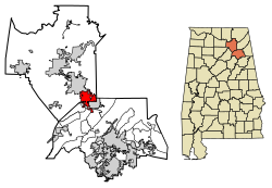 Location in Etowah and Marshall counties, Alabama | |
| Coordinates: 34°12′10″N 86°9′37″W | |
| Country | United States |
| State | Alabama |
| Counties | Marshall, Etowah |
| Government | |
| • Type | Mayor and Council |
| • Mayor | David Dyar |
| Area | |
| • Total | 14.61 sq mi (37.85 km2) |
| • Land | 14.55 sq mi (37.68 km2) |
| • Water | 0.06 sq mi (0.16 km2) |
| Elevation | 1,070 ft (330 m) |
| Population (2020)[3] | |
| • Total | 10,107 |
| • Density | 694.64/sq mi (268.2/km2) |
| Time zone | UTC-6 (Central (CST)) |
| • Summer (DST) | UTC-5 (CDT) |
| ZIP codes | 35957, 35956 |
| Area code | 256 |
| FIPS code | 01-07912 |
| GNIS feature ID | 0114631[2] |
| Website | www |
History
First settled in the 1850s, the town of Boaz was officially founded November 11, 1878, by the Sparks family of Georgia.[5] A post office has been in operation since 1887.[6] The city was named after Boaz, from the Bible.[7] It was incorporated in 1897.
The Julia Street Memorial United Methodist Church, Snead Junior College Historic District, the Thomas A. Snellgrove Homestead and the Edward Fenns Whitman House are listed on the National Register of Historic Places. The Alabama Register of Landmarks and Heritage lists the Boaz Elementary School, the First Baptist Church and Cemetery, and the Methodist Episcopal Church, South.[5]
Geography
Boaz is located in southeastern Marshall County at 34°12′10″N 86°9′38″W (34.202793, −86.160457)[8] and extends south into Etowah County. The city sits atop Sand Mountain (a plateau) at 1,080 feet (330 m) above sea level. It is bordered to the north by Albertville and to the southeast by Sardis City. U.S. Route 431 passes through the east side of the city, leading north 16 miles (26 km) to Guntersville and south 20 miles (32 km) to Gadsden.
According to the U.S. Census Bureau, the city of Boaz has a total area of 14.6 square miles (38 km2), of which 0.06 square miles (0.16 km2), or 0.43%, are water.[1] Most of the city drains west to either Slab Creek or Clear Creek, tributaries of the Locust Fork of the Black Warrior River. The Tennessee Valley Divide crosses the east side of the city, with the eastern portions of the city draining to Short Creek, a north-flowing tributary of the Tennessee River.
Demographics
| Historical population | |||
|---|---|---|---|
| Census | Pop. | %± | |
| 1900 | 253 | — | |
| 1910 | 1,010 | 299.2% | |
| 1920 | 1,369 | 35.5% | |
| 1930 | 1,691 | 23.5% | |
| 1940 | 1,927 | 14.0% | |
| 1950 | 3,078 | 59.7% | |
| 1960 | 4,654 | 51.2% | |
| 1970 | 5,635 | 21.1% | |
| 1980 | 7,151 | 26.9% | |
| 1990 | 6,928 | −3.1% | |
| 2000 | 7,411 | 7.0% | |
| 2010 | 9,551 | 28.9% | |
| 2020 | 10,107 | 5.8% | |
| U.S. Decennial Census[9] | |||
2010 census
At the 2010 census, there were 9,551 people, 3,712 households, and 2,479 families living in the city. The population density was 782.9 inhabitants per square mile (302.3/km2). There were 4,036 housing units at an average density of 330.8 per square mile (127.7/km2). The racial makeup of the city was 87.3% White, 1.8% Black or African American, 0.4% Native American, 0.7% Asian, 0.3% Pacific Islander, 7.9% from other races, and 1.6% from two or more races. 14.2% of the population were Hispanic or Latino of any race.
Of the 3,712 households 30.7% had children under the age of 18 living with them, 46.7% were married couples living together, 14.3% had a female householder with no husband present, and 33.2% were non-families. 29.6% of households were one person and 14.7% were one person aged 65 or older. The average household size was 2.52 and the average family size was 3.11.
The age distribution was 25.9% under the age of 18, 9.5% from 18 to 24, 26.0% from 25 to 44, 22.2% from 45 to 64, and 16.4% 65 or older. The median age was 36 years. For every 100 females, there were 90.0 males. For every 100 females age 18 and over, there were 95.4 males.
The median household income was $31,172 and the median family income was $42,973. Males had a median income of $32,446 versus $27,924 for females. The per capita income for the city was $17,697. About 11.7% of families and 16.0 of the population were below the poverty line, including 24.1% of those under age 18 and 17.1% of those age 65 or over.
2000 census
At the 2000 census, there were 7,411 people, 3,155 households, and 2,085 families living in the city. The population density was 607.7 inhabitants per square mile (234.6/km2). There were 3,468 housing units at an average density of 284.4 per square mile (109.8/km2). The racial makeup of the city was 93.50% White, 1.31% Black or African American, 0.47% Native American, 0.45% Asian, 0.04% Pacific Islander, 3.01% from other races, and 1.23% from two or more races. 4.98% of the population were Hispanic or Latino of any race.
Of the 3,155 households 28.7% had children under the age of 18 living with them, 50.8% were married couples living together, 12.6% had a female householder with no husband present, and 33.9% were non-families. 30.7% of households were one person and 16.3% were one person aged 65 or older. The average household size was 2.30 and the average family size was 2.86.
The age distribution was 23.0% under the age of 18, 8.3% from 18 to 24, 26.2% from 25 to 44, 23.3% from 45 to 64, and 19.2% 65 or older. The median age was 39 years. For every 100 females, there were 83.8 males. For every 100 females age 18 and over, there were 78.5 males.
The median household income was $25,699 and the median family income was $34,018. Males had a median income of $29,504 versus $21,750 for females. The per capita income for the city was $15,664. About 13.9% of families and 18.7% of the population were below the poverty line, including 20.7% of those under age 18 and 25.4% of those age 65 or over.
2020 census
| Race | Num. | Perc. |
|---|---|---|
| White (non-Hispanic) | 7,264 | 71.87% |
| Black or African American (non-Hispanic) | 189 | 1.87% |
| Native American | 43 | 0.43% |
| Asian | 57 | 0.56% |
| Pacific Islander | 98 | 0.97% |
| Other/Mixed | 407 | 4.03% |
| Hispanic or Latino | 2,049 | 20.27% |
As of the 2020 United States census, there were 10,107 people, 3,494 households, and 2,197 families residing in the city.
Schools
In May 2004, five schools broke away from the Marshall County School system and formed the Boaz City School System.
Boaz is the site of Snead State Community College.
Climate
Climate is characterized by relatively high temperatures and evenly distributed precipitation throughout the year. The Köppen Climate Classification subtype for this climate is "Cfa" (Humid Subtropical Climate).
Notable people
- James Fischer, engineer who developed high-purity silicon technology for Texas Instruments
- Tim Hodge, voice actor and director for Big Idea Entertainment
- Jody Hunt, United States Assistant Attorney General (2018–2020)
- Rose Maddox, country music singer-songwriter and fiddle player
- Eddie Priest, former Major League Baseball pitcher
- John Roberts, Navy Cross recipient
References
- "2021 U.S. Gazetteer Files". United States Census Bureau. Retrieved April 14, 2022.
- U.S. Geological Survey Geographic Names Information System: Boaz, Alabama
- "Boaz city, Alabama: 2020 DEC Redistricting Data (PL 94-171)". U.S. Census Bureau. Retrieved April 14, 2022.
- "Last call for Boaz Outlet Center". May 2, 2016.
- James P. Kaetz. "Boaz". Encyclopedia of Alabama. Retrieved October 13, 2016.
- "Marshall County". Jim Forte Postal History. Retrieved October 30, 2015.
- "Tenbroeck in DeKalb County was named for runaway horse". Gadsden Times. June 17, 1984. pp. B1. Retrieved October 30, 2015.
- "US Gazetteer files: 2010, 2000, and 1990". United States Census Bureau. February 12, 2011. Retrieved April 23, 2011.
- "U.S. Decennial Census". Census.gov. Retrieved June 6, 2013.
- "Explore Census Data". data.census.gov. Retrieved December 11, 2021.
External links
Municipalities and communities of Marshall County, Alabama, United States | ||
|---|---|---|
County seat: Guntersville | ||
| Cities |  | |
| Towns | ||
| CDPs | ||
| Unincorporated communities | ||
| Ghost town | ||
| Footnotes | ‡This populated place also has portions in an adjacent county or counties | |
| ||
Municipalities and communities of Etowah County, Alabama, United States | ||
|---|---|---|
County seat: Gadsden | ||
| Cities |
|  |
| Towns | ||
| CDPs | ||
| Unincorporated communities |
| |
| Former City | ||
| Footnotes | ‡This populated place also has portions in an adjacent county or counties | |
| ||
Authority control | |
|---|---|
| General | |
| National libraries | |
| Other | |
На других языках
[de] Boaz (Alabama)
Boaz ist eine Stadt im Etowah und Marshall County im Bundesstaat Alabama in den Vereinigten Staaten.- [en] Boaz, Alabama
Другой контент может иметь иную лицензию. Перед использованием материалов сайта WikiSort.org внимательно изучите правила лицензирования конкретных элементов наполнения сайта.
WikiSort.org - проект по пересортировке и дополнению контента Википедии