world.wikisort.org - USA
Bloomfield (formerly, Adams[3]) is a small unincorporated hamlet in Dawson County, Montana, United States.[2] It is located 23 miles (37 km) northeast of the Yellowstone River and the city of Glendive, which is the county seat for Dawson County.[2] Bloomfield is inside area code 406 and has a post office with ZIP code 59315.[4] The population of the community was 150 at the 2010 census.[5]
Bloomfield, Montana | |
|---|---|
Unincorporated hamlet | |
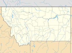  Bloomfield Location of Bloomfield, Montana  Bloomfield Bloomfield (the United States) | |
| Coordinates: 47°24′46″N 104°55′02″W | |
| Country | United States |
| State | Montana |
| County | Dawson |
| Area | |
| • Total | 0.06 sq mi (0.15 km2) |
| • Land | 0.06 sq mi (0.15 km2) |
| • Water | 0.00 sq mi (0.00 km2) |
| Elevation | 2,615 ft (797 m) |
| Population (2020) | |
| • Total | 6 |
| • Density | 101.69/sq mi (39.27/km2) |
| Time zone | UTC-7 (Mountain (MST)) |
| • Summer (DST) | UTC-6 (MDT) |
| ZIP code | 59315 |
| Area code | 406 |
| GNIS feature ID | 780133[2] |
The town takes its name from Bloomfield, Nebraska, hometown of settlers J. Berton and Dave Crockett.[6] They were soon followed by other Bloomfield families. Previously the town was part of an Amish community.[6]
Demographics
| Historical population | |||
|---|---|---|---|
| Census | Pop. | %± | |
| 2020 | 6 | — | |
| U.S. Decennial Census[7] | |||
Climate
According to the Köppen Climate Classification system, Bloomfield has a semi-arid climate, abbreviated "BSk" on climate maps.[8]
References
- "ArcGIS REST Services Directory". United States Census Bureau. Retrieved September 5, 2022.
- "Bloomfield". Geographic Names Information System. United States Geological Survey, United States Department of the Interior.
- "Visit Montana - Bloomfield". Retrieved 6 January 2014.
- "Bloomfield, MT Zip Codes". Zip-Codes.com. Retrieved 6 January 2014.
- "U.S. Census website". United States Census Bureau. Retrieved 6 January 2014.
- "Montana Place Names Companion". Montana Historical Society. Retrieved 25 July 2017.
- "Census of Population and Housing". Census.gov. Retrieved June 4, 2016.
- Climate Summary for Bloomfield, Montana
Municipalities and communities of Dawson County, Montana, United States | ||
|---|---|---|
County seat: Glendive | ||
| City | 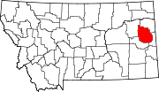 | |
| Town | ||
| CDPs | ||
| ||
 | This Dawson County, Montana state location article is a stub. You can help Wikipedia by expanding it. |
Другой контент может иметь иную лицензию. Перед использованием материалов сайта WikiSort.org внимательно изучите правила лицензирования конкретных элементов наполнения сайта.
WikiSort.org - проект по пересортировке и дополнению контента Википедии