world.wikisort.org - USA
Big Pine Key is a census-designated place and unincorporated community in Monroe County, Florida, United States, on an island of the same name in the Florida Keys. As of the 2000 census, the town had a total population of 5,032.
Big Pine Key, Florida | |
|---|---|
Census-designated place (CDP) & Unincorporated community | |
 Location in Monroe County and the state of Florida | |
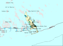 U.S. Census Bureau map showing CDP boundaries | |
| Coordinates: 24°40′12″N 81°21′14″W[1] | |
| Country | United States |
| State | Florida |
| County | Monroe |
| Area | |
| • Total | 10.31 sq mi (26.70 km2) |
| • Land | 10.20 sq mi (26.43 km2) |
| • Water | 0.11 sq mi (0.28 km2) |
| Elevation | 3 ft (1 m) |
| Population (2020) | |
| • Total | 4,521 |
| • Density | 443.06/sq mi (171.07/km2) |
| Time zone | UTC-5 (Eastern (EST)) |
| • Summer (DST) | UTC-4 (EDT) |
| ZIP code | 33043 |
| Area code | 305 |
| FIPS code | 12-06425[3] |
Geography

U.S. 1 (or the Overseas Highway) crosses the key at mile markers 29.5–33, one of the few places on the keys where the road orients north–south (along the eastern edge of the Key).
Big Pine Key was the location of one of the stations of the Overseas Railroad.
According to the United States Census Bureau, the CDP has a total area of 25.8 km2 (10.0 sq mi), of which 25.3 km2 (9.8 sq mi) is land and .5 km2 (0.2 sq mi) (1.81%) is covered by water.
Demographics
| Historical population | |||
|---|---|---|---|
| Census | Pop. | %± | |
| 2020 | 4,521 | — | |
| U.S. Decennial Census[4] | |||
2020 census
| Race | Number | Percentage |
|---|---|---|
| White (non-Hispanic) | 3,612 | 79.89% |
| Black or African American (non-Hispanic) | 49 | 1.08% |
| Native American | 9 | 0.2% |
| Asian | 46 | 1.02% |
| Pacific Islander | 2 | 0.04% |
| Other/Mixed | 182 | 4.03% |
| Hispanic or Latino | 621 | 13.74% |
As of the 2020 United States census, there were 4,521 people, 2,065 households, and 1,180 families residing in the CDP.
2000 census
As of the census[3] of 2000, 5,032 people, 2,247 households, and 1,420 families resided in the CDP. The population density was 198.9/km2 (515.3/mi2). The 3,153 housing units averaged 124.6/km2 (322.9/mi2). The racial makeup of the CDP was 94.83% White, 1.09% African American, 0.50% Native American, 0.58% Asian, 0.02% Pacific Islander, 1.19% from other races, and 1.79% from two or more races. Hispanics or Latinos of any race were 6.72% of the population.
Of the 2,247 households, 41.4% had children under the age of 18 living with them, 43.8% were married couples living together, 5.7% had a female householder with no husband present, and 6.8% were not families. About 26.0% of all households were made up of individuals, and 7.8% had someone living alone who was 65 years of age or older. The average household size was 2.21 and the average family size was 2.63.
In the CDP, the population was distributed as 16.8% under the age of 18, 4.3% from 18 to 24, 30.3% from 25 to 44, 33.7% from 45 to 64, and 14.9% who were 65 years of age or older. The median age was 44 years. For every 100 females, there were 110.4 males. For every 100 females age 18 and over, there were 111.6 males.
The median income for a household in the CDP was $44,514, and for a family was $47,639. Males had a median income of $31,552 versus $28,021 for females. The per capita income for the CDP was $23,169. About 5.6% of families and 9.5% of the population were below the poverty line, including 17.4% of those under age 18 and 7.0% of those aged 65 or over.
The Blue Hole

The Blue Hole is an abandoned rock quarry that was used for nearby road fills and Henry Flagler's Overseas Railroad.[6] The water it contains is mostly fresh and is used by various wildlife in the area, such as birds, snakes, alligators and invasive green iguanas. It is part of the National Key Deer Refuge.[7]
Business and commerce
The primary grocery store is the Winn-Dixie, located in a shopping center just north of US 1. This shopping center contains several restaurants, a Beall's Outlet, a well-stocked Super RadioShack store (Now Called Keys Electronics after the death of the Radio Shack franchise), the visitor's center for the National Key Deer Refuge, and a branch of the Monroe County Library (with WiFi internet access). Walgreens and CVS pharmacies are located along US 1, as well as a shoe store, a tropical decor store, and a bait and tackle shop. A small hardware store in the same area sells typical paint, hardware, tools, other goods needed to build/repair items around the home, and a limited selection of parts for boat repair.
Several bars and restaurants are along the US 1 corridor. Good Food Conspiracy has served organic food for over two decades and the No Name Pub is near the bridge to No Name Key in the northeast part of the island. The nearest city of note is Marathon about 23 miles (37 km) "north" on US 1. Key West, a major shopping and cultural hub for the area, is about 30 miles (48 km) "south" on US 1.
Accommodations are limited, though RV/camping and a small number of motel-style units are available at the Big Pine Key Fishing Lodge on the far southeast side of the island.
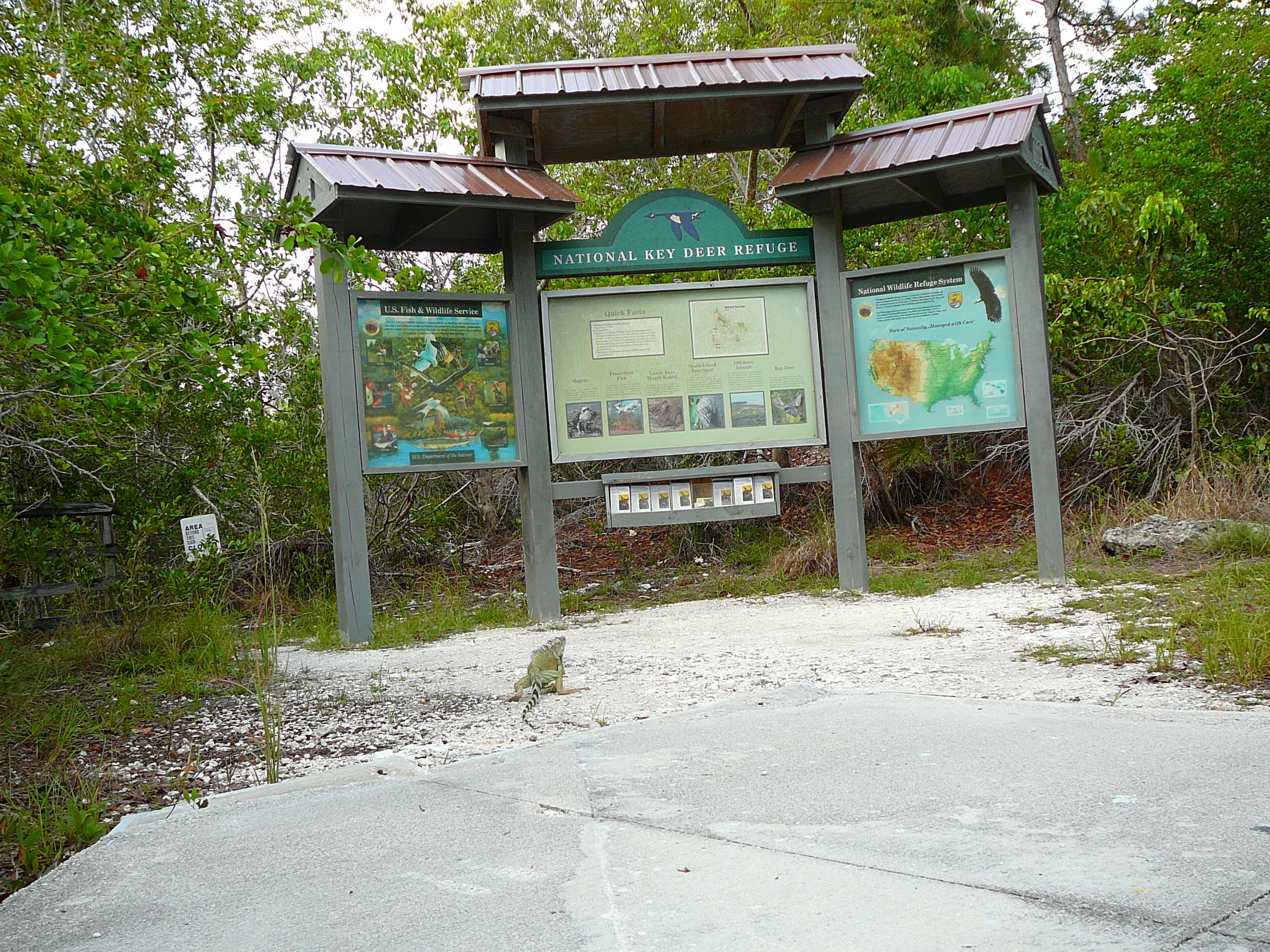
Key deer

The island of Big Pine Key is home to the National Key Deer Refuge; the majority of the Key deer population are found on this island.
As Key deer are endangered, many precautions have been taken to preserve as much Key deer habitat as possible:
- Signs are prominently placed along US 1 to inform drivers that they are entering Key deer habitat, and warning them that feeding Key deer is prohibited.
- About 2 miles of US 1 on the eastern end of Big Pine Key are elevated and fenced off to allow Key deer to pass under the road.
- The stretch of US 1 in Big Pine Key has a night-time speed limit of 35 miles per hour (as Key deer are most active at night) and the speed limits (45 MPH in the day) are "strictly enforced" according to signage.

References
- U.S. Geological Survey Geographic Names Information System: Big Pine Key, Florida
- "2020 U.S. Gazetteer Files". United States Census Bureau. Retrieved October 31, 2021.
- "U.S. Census website". United States Census Bureau. Retrieved 2008-01-31.
- "Census of Population and Housing". Census.gov. Retrieved June 4, 2016.
- "Explore Census Data". data.census.gov. Retrieved 2022-01-04.
- "The Florida Keys:Lower Keys". Archived from the original on 2008-12-05. Retrieved 2008-06-27.
- History of Big Pine Key; Big Pine Key Information Archived 2008-06-27 at the Wayback Machine
External links
 Media related to Big Pine Key, Florida at Wikimedia Commons
 Big Pine Key travel guide from Wikivoyage
Municipalities and communities of Monroe County, Florida, United States | ||
|---|---|---|
County seat: Key West | ||
| Cities |
|  |
| Village | ||
| CDPs |
| |
| Unincorporated communities |
| |
| Ghost towns |
| |
| ||
Authority control | |
|---|---|
| General |
|
| National libraries | |
На других языках
[de] Big Pine Key
Big Pine Key ist ein census-designated place (CDP) im Monroe County im US-Bundesstaat Florida. Das U.S. Census Bureau hat bei der Volkszählung 2020 eine Einwohnerzahl von 4.521[1] ermittelt.- [en] Big Pine Key, Florida
[fr] Big Pine Key
Big Pine Key est une île des Keys, archipel des États-Unis d'Amérique situé dans l'océan Atlantique au sud de la péninsule de Floride. Partie du comté de Monroe, qui recouvre la pointe méridionale de l'État, elle était peuplée de 5 032 habitants au recensement de 2000.[ru] Биг-Пайн-Ки (Флорида)
Статистически обособленная местностьБиг-Пайн-КиBig Pine Key, Florida 24°41′10″ с. ш. 81°21′40″ з. д.HGЯO Страна США Штат Флорида Округ Монро История и география Площадь 25,9 км² Высота центра 1 м Часовой пояс UTC−5:00, летом UTC−4:00 Население Население 5032 человека (2000) Плотность 194,29 чел./км² Цифровые идентификаторы Телефонный код +1 305 Почтовые индексы 33043 FIPS 12-06425 GNIS 2402688 и 294394 Показать/скрыть карты .mw-parser-output .ts-ПозКарта-метка{font-size:88%;line-height:1.2em;position:absolute;z-index:2}.mw-parser-output .ts-ПозКарта-метка-точка{position:relative;float:left;line-height:0}.mw-parser-output .ts-ПозКарта-метка-ссылка{position:absolute;width:156px;top:-0.5em}Биг-Пайн-Ки Биг-Пайн-Ки Медиафайлы на ВикискладеДругой контент может иметь иную лицензию. Перед использованием материалов сайта WikiSort.org внимательно изучите правила лицензирования конкретных элементов наполнения сайта.
WikiSort.org - проект по пересортировке и дополнению контента Википедии