world.wikisort.org - USA
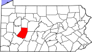
Alverda is an Census-designated place in Indiana County, Pennsylvania, United States.[3] The community is located on Pennsylvania Route 553 15.5 miles (24.9 km) east of Indiana in Pine Township. As of the 2020[4] census the community has a population of 279.[5] Alverda has a post office with ZIP code 15710.[6][7] It includes the neighborhood of Brownstown, historically a separate village.
Alverda, Pennsylvania | |
|---|---|
Unincorporated community | |
 Alverda  Alverda | |
| Coordinates: 40°37′49″N 78°51′25″W | |
| Country | United States |
| State | Pennsylvania |
| County | Indiana |
| Township | Pine |
| Area | |
| • Total | 0.82 sq mi (2.12 km2) |
| • Land | 0.82 sq mi (2.12 km2) |
| • Water | 0.00 sq mi (0.00 km2) |
| Elevation | 1,913 ft (583 m) |
| Population (2020)[2] | |
| • Total | 279 |
| • Density | 340.66/sq mi (131.61/km2) |
| Time zone | UTC-5 (Eastern (EST)) |
| • Summer (DST) | UTC-4 (EDT) |
| ZIP code | 15710 |
| Area code | 814 |
| GNIS feature ID | 1168240[3] |
Demographics
| Historical population | |||
|---|---|---|---|
| Census | Pop. | %± | |
| 2020 | 279 | — | |
| U.S. Decennial Census[8][2] | |||
At the 2020 census there were 279 people, 122 households in the community. The population density was 260.0 people per square mile (100.4/km2). There were 122 housing units at an average density of 45.9/sq mi (32.7/km2). The racial makeup of the community was 93.5% White, 0.1% African American, 0.03% American Indian or Alaska Native, and 0.4% from two or more races.
There were 122 households, 32.0% had children under the age of 18 living with them, 49.0% were married couples living together, 18.0% had a single guardian with no spouse present, and 33.0% were non-families.
References
- "ArcGIS REST Services Directory". United States Census Bureau. Retrieved October 12, 2022.
- "Census Population API". United States Census Bureau. Retrieved Oct 12, 2022.
- "Alverda". Geographic Names Information System. United States Geological Survey, United States Department of the Interior.
- "Alverda Profile". data.census.gov.
- "ZIP Code 15710, Alverda PA, Database - Alverda Pennsylvania Map, U.S. ZIP Codes". www.zip-codes.com.
- United States Postal Service. "USPS - Look Up a ZIP Code". Retrieved December 19, 2015.
- "Postmaster Finder - Post Offices by ZIP Code". United States Postal Service. Retrieved December 19, 2015.
- "Census of Population and Housing". Census.gov. Retrieved June 4, 2016.
Другой контент может иметь иную лицензию. Перед использованием материалов сайта WikiSort.org внимательно изучите правила лицензирования конкретных элементов наполнения сайта.
WikiSort.org - проект по пересортировке и дополнению контента Википедии
