world.wikisort.org - Regno_Unito
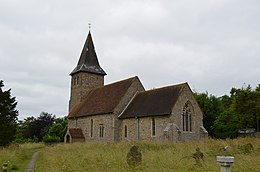
Postling è un villaggio e parrocchia civile dell'Inghilterra, appartenente alla contea del Kent.
| Postling parrocchia civile | |
|---|---|
 | |
| Localizzazione | |
| Stato | |
| Regione | Sud Est |
| Contea | |
| Distretto | Folkestone and Hythe |
| Territorio | |
| Coordinate | 51°06′38.88″N 1°03′52.56″E |
| Abitanti | 206 (2011) |
| Altre informazioni | |
| Prefisso | 01303 |
| Fuso orario | UTC+0 |
| Cartografia | |
Altri progetti
 Wikimedia Commons contiene immagini o altri file su Postling
Collegamenti esterni
- (EN) Sito web del Kent, su kent.gov.uk.
На других языках
[en] Postling
Postling village and civil parish is situated near the Roman road of Stone Street, about 17 miles (27 km) south of Canterbury, Kent, in South East England. Postlinges is the spelling used in the Domesday Book where it was part of the lands of Hugo de Montfort; Postlinge is also seen in old records. There is much archaeological evidence of continued occupation of the area. Postling Court is, in effect, the old manor-house, although is, more correctly as the name suggests, the one-time meeting place of the local court and magistrate. The population of the civil parish includes the hamlet of Newbarn.- [it] Postling
Текст в блоке "Читать" взят с сайта "Википедия" и доступен по лицензии Creative Commons Attribution-ShareAlike; в отдельных случаях могут действовать дополнительные условия.
Другой контент может иметь иную лицензию. Перед использованием материалов сайта WikiSort.org внимательно изучите правила лицензирования конкретных элементов наполнения сайта.
Другой контент может иметь иную лицензию. Перед использованием материалов сайта WikiSort.org внимательно изучите правила лицензирования конкретных элементов наполнения сайта.
2019-2025
WikiSort.org - проект по пересортировке и дополнению контента Википедии
WikiSort.org - проект по пересортировке и дополнению контента Википедии
