world.wikisort.org - United_Kingdom
Wymington is a small village and civil parish in the borough of Bedford in northern Bedfordshire, England. It is located around a mile and a half south of Rushden, in the neighbouring county of Northamptonshire, and about 10 miles north-northwest of Bedford.[2]
| Wymington | |
|---|---|
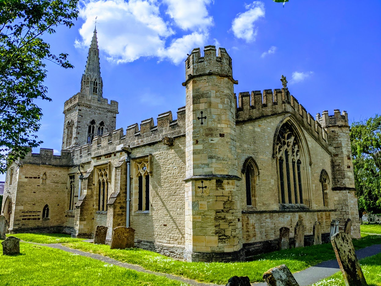 Parish Church of St. Lawrence, Wymington | |
 Wymington Location within Bedfordshire | |
| Population | 876 (2011 Census)[1] |
| OS grid reference | SP955196 |
| Civil parish |
|
| Unitary authority |
|
| Ceremonial county | |
| Region | |
| Country | England |
| Sovereign state | United Kingdom |
| Post town | RUSHDEN |
| Postcode district | NN10 |
| Dialling code | 01933 |
| Police | Bedfordshire |
| Fire | Bedfordshire and Luton |
| Ambulance | East of England |
| UK Parliament |
|
As of 2011, the parish of Wymington had a population of 876. The village is home to a 14th century parish church, a Weslyan chapel, a school, and a pub. One bus line stops in the village and provides service to Rushden and Bedford.[3] A small brook runs through the village that drains into the River Nene about 3 miles north.[2]
Throughout its history Wymington has been referred to by various names, including Wimmington, Winnington, Wimentone, Wimuntun, and Widmintun, among others.[4][5] The name is derived from Old English and refers to a 'tun' held by a person named Wigmund or Wimund.[4] Wymington is home to numerous listed buildings in the village, including the Grade 1 listed parish church.[6]
History
Prehistory and Roman settlement
Evidence exists of Neolithic and Bronze-age settlement of the Wymington area. Flint implements have been discovered in the area, and in the 1860s a hoard of 60 socketed axes was found on a farm near Wymington, possibly from an ancient bronze smith's stock.[7]
Substantial evidence of Roman and Romano-Belgic settlement exists. A complex of enclosures visible today in the form of cropmarks and ditches as well as buried roof tiles and sherds about 700m south of the modern village probably dates from the 1st to 5th century.[8] Additional evidence of Roman occupation has been discovered northwest of the village, where 3rd century pottery, a quern, building rubble, coins, belt buckles, and jewelry have been discovered.[9]
Middle ages
Evidence of Saxon settlement was uncovered during an expansion of the Wymington school. Shards of early to middle Saxon pottery were discovered in ditches that had probably been dug in the 12th to 13th century.[10]
Wymington was recorded in the Domesday Book of 1086 as a parish within the Hundred of Willey.[11] Four tenants were referenced in the survey, two of whom held manors. By the 1350s, John Curteys had taken possession of one of the larger of the two manors. Curteys, who was mayor of the wool staple of Calais, held considerable wealth. He provided funds to re-build the village church and made a loan to Richard II in the sum of £20, an extremely substantial amount at the time. The only remaining medieval building in the village is the church, which dates to the mid 14th century.[12]
Modern era
By the early 17th century, Wymington was home to two manors, both referred to as Wymington Manor. Only one manor house remains, dating from 1612 on the north side of the village. The other manor house was probably on the south side of the village, on the south side of the High Street.[13]
In the mid 18th century, Wymington was referenced as a "obscure and ruinous village," with 35 stone thatched houses and a population of 216.[5] By 1870, the number of houses in Wymington had risen to 71. In the late 19th century, the economy of Rushden shifted from reliance on agriculture to industry - specifically, the boot and shoe trade in nearby Northamptonshire.[13] Also in 1870, a second church was built in the village. This church, a Weslyan chapel, was built to house a congregation that had been meeting in homes since 1833.[14]
In August, 1944 a damaged United States Army Air Forces B-17 "Miss Liberty Belle" based at nearby RAF Chelveston crashed while returning from a mission. The aircraft crashed after narrowly avoiding the church tower, colliding with trees and landing in a field on the southern edge of the village. Eight villagers as well as a soldier of the Czech Army billeted nearby were able to pull all the crew members from the flaming wreckage, though only one survived.[15]
In the mid-20th century, much of the old 16th to 18th century housing was demolished as part of a development project headed by the Rural Council. Council housing was constructed in the middle of the village along the High Street, and a housing estate was built to the south.[13]
Geography
Wymington is situated in a far northwestern corner of Bedfordshire, with the parish boundary following the county line with Northamptonshire. While the village is surrounded by farms, the land was never considered suitable for market gardening as is common in the rest of northern Bedfordshire. The village lies at the intersection of three roads that lead north to Rushden, southwest to Podington, and a lane that connects with the road to Bedford to the east.[13]
Neighbouring parishes | |
|---|---|
Demography
LandmarksNature ReserveSharnbrook Summit and Wymington Meadow nature reserve is located near Wymington to the south.[17] Grade I listed buildingsIn the mid-14th century the only grade I listed building in the village, the Parish Church of St. Lawrence, was built.[6] The church was constructed at the behest of John Curteys, a wealthy manor holder and mayor of the wool staple of Calais. It was built in the decorated style and is noted for its brasses and surviving late Medieval art, including a large doom painted over the chancel arch.[18] Curteys died in 1391 and was buried in the church. The church is also home to the tomb of Sir Thomas Brounflet, cupbearer for Richard II.[19] Grade II listed buildingsThree buildings in Wymington are Grade II listed:[6] War memorialsA war memorial commemorating the men of the village killed in war resides in the church cemetery. It holds the names of the 24 men who died in the First World War, and the names of the 8 killed in the Second World War. Additionally, the village hall was dedicated as a memorial to those killed in the wars. A memorial to the crew of the B-17 that crashed in the village in 1944 sits in a grove south of the village. The memorial consists of a plaque, iron bench with the symbol of the 8th Air Force, and a flag pole, and was dedicated on 7 May 2000.[15] References
External links
|
Другой контент может иметь иную лицензию. Перед использованием материалов сайта WikiSort.org внимательно изучите правила лицензирования конкретных элементов наполнения сайта.
WikiSort.org - проект по пересортировке и дополнению контента Википедии