world.wikisort.org - United_Kingdom
Piddinghoe is a village and civil parish in the Lewes District of East Sussex, England. It is located in the valley of the River Ouse between Lewes and Newhaven, five miles (8 km) south of the former, downstream of Southease.
| Piddinghoe | |
|---|---|
 The Old Post Office, Piddinghoe | |
 Piddinghoe Location within East Sussex | |
| Area | 3.8 km2 (1.5 sq mi) [1] |
| Population | 255 (Parish-2011)[2] |
| • Density | 180/sq mi (69/km2) |
| OS grid reference | TQ433031 |
| • London | 48 miles (77 km) N |
| District |
|
| Shire county | |
| Region | |
| Country | England |
| Sovereign state | United Kingdom |
| Post town | NEWHAVEN |
| Postcode district | BN9 |
| Dialling code | 01273 |
| Police | Sussex |
| Fire | East Sussex |
| Ambulance | South East Coast |
| UK Parliament |
|
The village was once a central player in Sussex smuggling.[not verified in body] It is also notable for having the only remaining bottle-shaped brick kiln in the country.[not verified in body]
Piddinghoe is regularly visited by sailing enthusiasts as the body of water by the village is a fine location for dinghy sailing in particular but also windsurfing.[3]
An old saying of unknown origin says that "Piddinghoe people shoe their magpies".[4] One theory is that this refers to the habit of shoeing oxen, which if black and white, were called magpies.[5]
History
Piddinghoe does not appear in the Domesday Book, but by 1220 a manor of that name was in the hands of William de Warenne.[4]
In the 13th century the village name appears as Peddinghowe or Pidingeho and in the 14th century as Pydynghowe.[4] It means "hill-spur of the family or followers of a man called Pyda".[6]
The village was part of the Holmstrow hundred until the abolition of hundreds in the 19th century.[7]
In 1929 part of the parish on the coast was made into the parish of Peacehaven.[4]
Notable buildings and areas

There are a number of notable areas around Piddinghoe. From east to west it runs from River Ouse, over the Downs to Peacehaven. Due north is Southease and south is Newhaven.
St John's Church
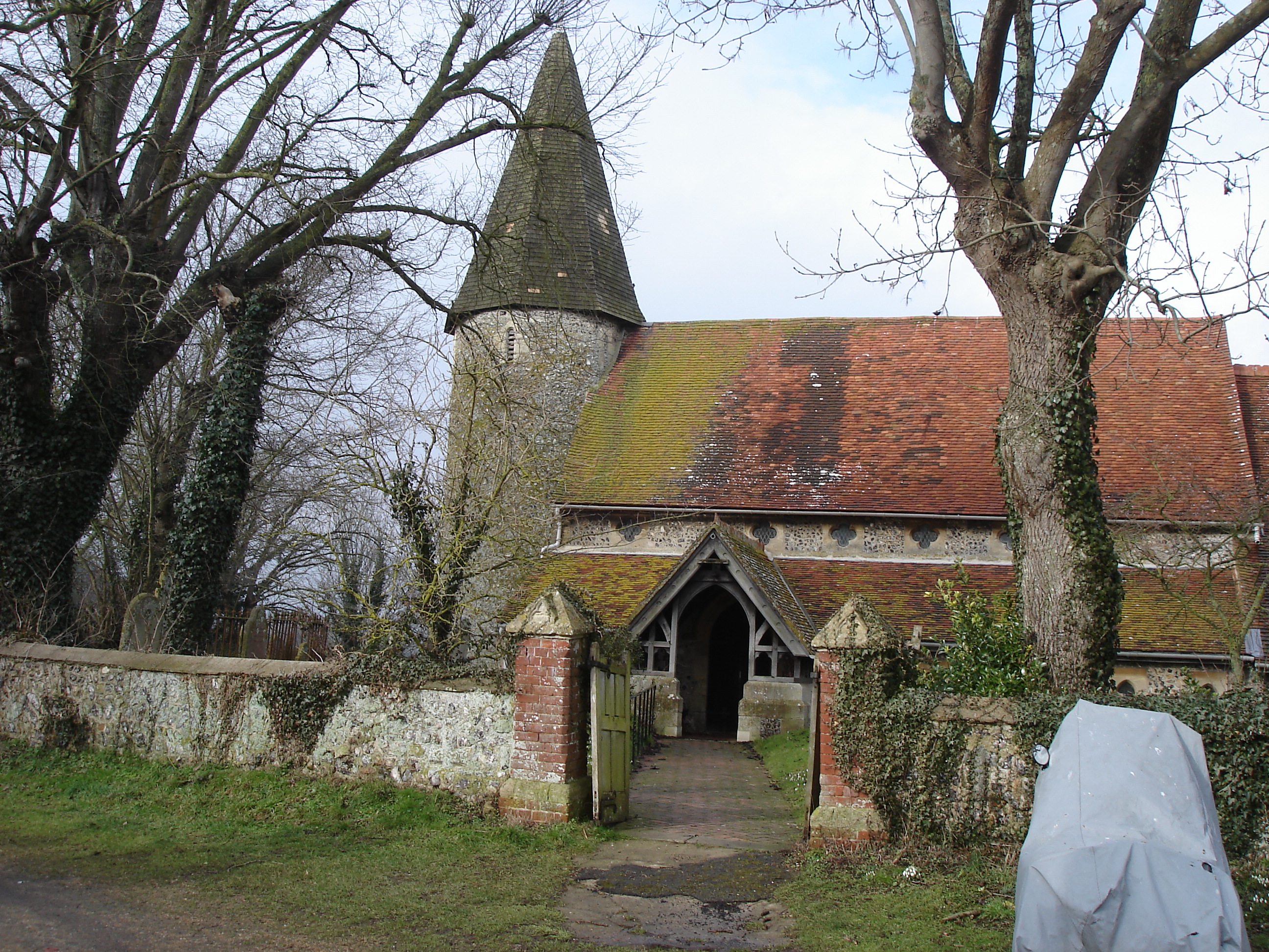
St John's Church is one of three in the Ouse Valley with a round Norman tower, the others being at nearby Southease and St Michael’s, Lewes. It may be built upon a large prehistoric burial mound, again like Southease upstream.[8]
Court Farm
Court Farm once farmed much of the surrounding downland the land close to the farmstead is now a smallholding with pigs. The house is medieval and the derelict flint barns are similarly old. The little wildfowl lake was a Victorian brickfield.[8]
Piddinghoe Pond

Piddinghoe pond was a quarry site from the late 19th century. By the mid 1950's excavation had stopped and the pit had filled with water. It has now been acquired by the Newhaven & Seaford Sailing Club.[9]
Broadgreen Bottom
Despite the Downs around Piddinghoe once being almost entirely old Down pasture, now the best surviving fragment is to the north of the parish on the Southease border on the north slope of Broadgreen Bottom (TQ 420 038). The western end is scruffy and there were many rabbits until a few years ago, so you might find hound’s tongue and wild thyme and other open ground short-lived species. The eastern end of the Downslope has old Down pasture perennials, like round-headed rampion, horseshoe vetch, Devil's bit scabious and Autumn Ladies'-tresses orchid. The south slope of Broadgreen Bottom has a long Gorse bank that is used for game bird cover.[8]
A new barn-like house has been built at the top of The Lookout, north of Peacehaven (TQ 415 033).[citation needed]
Money Burgh
The Money Burgh (TQ 424 036) is a Neolithic long barrow dominating the narrow strait of the Ouse valley. It is possible that prehistoric people crossed the estuary here as a medieval ferry crossed at Stock Cottages, nearby.[8]
The Burgh itself is large and oval in shape. The mound is 32m by 10m (12m at the eastern end) and towards the northeast end the mound stands over 2m tall although much it is well dug over by people looking for any remaining treasure they can find. In the past a skeleton has been found in it and a number of other artefacts.[10] The Burgh still has round-headed rampion and other old herbs upon it, although it is surrounded by the "improved" horse fields of Dean’s Farm. Next to Dean’s Farm are many game bird rearing pens and the gamekeepers’ cottages. Unfortunately, this part of the Downs is crawling with pheasant and partridge, which put major stress on native species.[8][11]
Halcombe

Between north Peacehaven and Piddinghoe lies the peaceful Halcombe valley. It has chalk grassland on both its south and north slopes, and the lower valley has a finger of brook meadows, with old flint walls and reedy ditches. The south slope and the spur between Halcombe and Piddinghoe have very tall and steep medieval lynchets. The spur’s wooded slope overlooking the Newhaven Road is even steeper and is likely to be an ancient river cliff.[8]
The south slope of Halcombe (TQ 427 031) is the best Down pasture site on the Peacehaven Downs. The variety of the place means that in some summers it can be dancing with dark green fritillary, marbled white, chalkhill blue, and many other butterflies as well as many varieties of moths, bees, and spiders. It has old anthills, mossy turf and rich scrub fringe and in spring there are early purple orchid. However the area has been threatened. In 2005 the farmer placed a large pheasant pen on these pastures. Activists were quick to inform DEFRA who instructed the farmer to remove it, although the pen is still on a part of the site. The north slope of Halcombe (TQ 423 031) has lost much of its old pasture to scrub, but the turf that remains is very rich. There is Dyer’s greenweed, round-headed rampion, squinancywort, common gromwell and hound’s tongue. The site is at risk from scrub encroachment although some chalkhill blue are still present in high summer.[8]
Nore Down

Nore Down (TQ 431 023) has a rumpled top that marks the presence of the Tertiary sands and clays underneath. On its west flank there are large medieval lynchets, but the valley, like much of the downland in this area, has been turned over to game shooting, and there is cover crops and a giant rearing pen covering part of once chalk grassland slope.[8]
Nearest parishes | ||||||||||||||||
|---|---|---|---|---|---|---|---|---|---|---|---|---|---|---|---|---|
| ||||||||||||||||
Governance
At a local level Piddinghoe is governed by Piddinghoe Parish Council. Their responsibilities include footpaths, street lighting, playgrounds and minor planning applications. The parish council has five seats available[12] although only four were filled in the uncontested May 2007 election.[13]
The next level of government is the district council. The parish of Piddinghoe lies within the Kingston ward of Lewes District Council, which returns a single seat to the council. The election on 12 May 2015 returned a Liberal Democrat[14]
East Sussex County Council is the next tier of government, for which Piddinghoe is within the Newhaven and Ouse Valley West division, with responsibility for education, libraries, social services, civil registration, trading standards and transport. elections for the county council are held every four years. The Liberal Democrat Carla Butler was elected in the 2013 election.[15]
The UK Parliament constituency for Piddinghoe is Lewes. The Liberal Democrat Norman Baker served as the constituency MP from 1997 until 2015, when Conservative Maria Caulfield was elected.
Prior to Brexit in 2020, the village was part of the South East England constituency in the European Parliament.
References
- "East Sussex in Figures". East Sussex County Council. Retrieved 26 April 2008.
- "Civil Parish population 2011". Retrieved 12 October 2015.
- "Dinghy sailing and windsurfing". Retrieved 18 January 2009.
- Piddinghoe, Louis Francis Salzman, A History of the County of Sussex: Volume 7
- Newhaven to Lewes Archived 2009-08-16 at the Wayback Machine
- Mills, A. D. (1996). A Dictionary of British Place Names. Oxford: Oxford University Press. p. 368. ISBN 9780199609086. Retrieved 4 August 2022.
- Parliamentary Papers, House of Commons and Command, Volume 11. H M Stationery Office. 1831.
- Bangs, Dave (2008). A freedom to roam Guide to the Brighton Downs : from Shoreham to Newhaven and Beeding to Lewes. Brighton: David Bangs. ISBN 978-0-9548638-1-4. OCLC 701098669.
- "Brighton Watersports at Piddinghoe Lake". Brighton Watersports. Retrieved 25 January 2022.
- "Money Burgh, oval barrow 200m west of Deans Farm, Piddinghoe - 1013127 | Historic England". historicengland.org.uk. Retrieved 25 January 2022.
- "Pheasant and partridge classified as species that imperil UK wildlife". the Guardian. 30 October 2020. Retrieved 26 January 2022.
- Crawford, John (19 March 2007). "Notice of Election" (PDF). Lewes District Council. Archived from the original (PDF) on 27 July 2009. Retrieved 15 November 2008.
- "Results – Town and Parish Council Elections" (PDF). Lewes District Council. 3 May 2007. Archived from the original (PDF) on 25 February 2009. Retrieved 24 September 2008.
- "Election Results". Lewes District Council. 4 May 2007. Archived from the original on 18 September 2008. Retrieved 15 November 2008.
- "Councillor David Rogers OBE". Find your Councillor. East Sussex County Council. Retrieved 15 November 2008.
External links
Другой контент может иметь иную лицензию. Перед использованием материалов сайта WikiSort.org внимательно изучите правила лицензирования конкретных элементов наполнения сайта.
WikiSort.org - проект по пересортировке и дополнению контента Википедии