world.wikisort.org - United_Kingdom
Newborough (Welsh: Niwbwrch) is a village in the south-western corner of the Isle of Anglesey in Wales; it is in the community (and former electoral ward) of Rhosyr, which has a population of 2,169,[1] increasing to 2,226 at the 2011 census.[2] the village itself having a population of 892 with 68% born in Wales.[3]
Newborough
| |
|---|---|
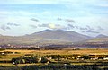
 the A4080 in Newborough with Snowdonia in background | |
 Newborough Location within Anglesey | |
| Population | 2,226 (2011) |
| OS grid reference | SH425655 |
| Community |
|
| Principal area |
|
| Ceremonial county | |
| Country | Wales |
| Sovereign state | United Kingdom |
| Post town | LLANGEFNI |
| Postcode district | LL61 |
| Dialling code | 01248 |
| Police | North Wales |
| Fire | North Wales |
| Ambulance | Welsh |
| UK Parliament |
|
| Senedd Cymru – Welsh Parliament |
|
History
In medieval Gwynedd, Rhosyr was the royal demesne (Welsh: maerdref) and seat of governance for the commote of Menai.[4] The ruined court buildings of Llys Rhosyr ('Rhosyr Court') lie on the outskirts of the present village. Their precise nature is uncertain, but archaeologists at Gwynedd Archaeological Trust consider them to have been a royal home and have established an exhibition of their findings in the village's Pritchard Jones Institute.
Modern Newborough was founded by citizens of Llanmaes in eastern Anglesey who were evicted by Edward I in 1294 in order to promote his new port of Beaumaris. It was, literally, established as a "new borough" and gained its charter in 1303. In the 16th century, Newborough was the county town of Anglesey. It was home to a thriving marram grass industry, used for producing matting, nets and rope. From 1541 to 1553 the constituency of Newborough returned a member to the English Parliament. John Morgan, a blind musician living around 1740, played the crwth in the village.
Newborough is the home of the Prichard Jones Institute, considered an exceptional example of an early 20th-century public institution. The Institute and the six single-storey cottage homes that accompany it were a gift to the village by Sir John Prichard-Jones, who was born in Newborough. Sir John served an apprenticeship as a draper, eventually rising to become chairman of the Dickins & Jones department store in London, to which he gave his name. The Institute was designed by Roland Lloyd Jones and completed in 1905 at a cost of £20,000. The neo-Tudor style two-storey building, complete with clock tower, is an unusually lofty design for a location often buffeted by strong south-westerly winds. The Institute appeared on the BBC2 programme, Restoration, in 2006.
The Welsh name 'Niwbwrch' (pronounced as: nɪʊbuːrx) is a corrupted form of the English; 'Newborough' with the silent letters 'gh' mistaken for the Welsh letter 'Ch' which is pronounced aloud with the voiceless velar fricative [x], akin to how the Welsh surname 'Goch' mutated into the anglicised spelling 'Gough'.
Today
The village and its environs provides walking opportunities for visitors, including at Newborough Warren, one of the largest areas of sand dunes in the British Isles, and Newborough Forest, a 2,000-acre (800 ha) woodland. Much of the area around Newborough is a nature reserve, popular for those interested in geology, botany, birds and other wildlife.
There is a large sandy Blue Flag beach at Llanddwyn, which provides access to Ynys Llanddwyn, a mile-long rocky promontory. The remains of the 16th-century church of Dwynwen, the Welsh patron saint of lovers, is located on the island. The beach is a popular kitesurfing location.
Newborough has a primary school, Ysgol Gynradd Niwbwrch, which in 2017 had 63 pupils, 71% of whom came from Welsh-speaking homes.[5]
Just outside the village is Tacla Taid, the Anglesey Transport and Agriculture Museum, the largest of its kind in Wales.
People from Newborough
- Sir John Prichard-Jones, 1st Baronet (1841–1917), businessman, partner in the London department store Dickins & Jones
- William Jones (1842–1907), master mariner, industrialist and civic leader, settled in Tasmania, Australia[6]
- Grace Wynne Griffith (1888–1963) novelist writing in Welsh, joint prize winner at the National Eisteddford in 1934.
Movies and television filmed in Newborough
- Coast, BBC television series
- Half Light, 2006 horror film starring Demi Moore
- Clash Of The Titans, 2010 historical fantasy film starring Sam Worthington
Photos of Newborough
 Newborough beach car park
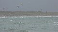 Kitesurfing on Newborough beach
 Gateway leading to St Peter's Church


References
- Office for National Statistics : Neighbourhood Statistics : Census 2001 : Isle of Anglesey
- "Ward/Community population 2011". Retrieved 20 May 2015.
- "Local area report". nomisweb.co.uk.
- Lloyd, John E. A History of Wales from the Earliest Times to the Edwardian Conquest, p. 232. Longmans, Green, & Co. (London), 1911. Accessed 20 Feb 2013.
- "Ysgol Gynradd Niwbwrch | Estyn". www.estyn.gov.wales. Retrieved 14 March 2017.
- W. G., Winter (1983). "Jones, William (1842–1907)". Australian Dictionary of Biography. Vol. 9. Melbourne University Press. ISSN 1833-7538. Retrieved 9 February 2022 – via National Centre of Biography, Australian National University.
External links
- "Criw Niwbwrch / Official Friends of the village website
- "More History of Newborough / Hanes Niwbwrch"
- "This walk is near Newborough village (BBC)"
- Prichard Jones Institute (BBC)
- Llys Rhosyr (BBC)
- photos of Newborough and surrounding area on geograph
| Towns |  | |
|---|---|---|
| Villages |
| |
| Hydrological features |
| |
| Ancient sites |
| |
| Islands | ||
| Topics |
| |
Другой контент может иметь иную лицензию. Перед использованием материалов сайта WikiSort.org внимательно изучите правила лицензирования конкретных элементов наполнения сайта.
WikiSort.org - проект по пересортировке и дополнению контента Википедии