world.wikisort.org - United_Kingdom
Madehurst is a small village and civil parish in the Arun District of West Sussex, England on the south slopes of the South Downs in the South Downs National Park. It is three miles (5 km) north-west of Arundel, to the west of the A29 road. The village of Madehurst is in two well-wooded valleys, listed in park guides.
| Madehurst | |
|---|---|
 Madehurst Lodge | |
 Madehurst Location within West Sussex | |
| Area | 7.66 km2 (2.96 sq mi) |
| Population | 120 (Civil Parish.2011)[1] |
| • Density | 16/km2 (41/sq mi) |
| OS grid reference | SU984100 |
| • London | 48 miles (77 km) NNE |
| Civil parish |
|
| District | |
| Shire county | |
| Region | |
| Country | England |
| Sovereign state | United Kingdom |
| Post town | ARUNDEL |
| Postcode district | BN18 |
| Dialling code | 01903 |
| Police | Sussex |
| Fire | West Sussex |
| Ambulance | South East Coast |
| UK Parliament |
|
Economy
Many of the few inhabitants are farmers, retired, or commute as far afield as London, Portsmouth or Brighton.
The parish church

The Anglican parish church, dedicated to St. Mary Magdalene, is built of local flint. It was restored and enlarged in 1864,[2] when the north aisle and a new chancel were added.
Notable residents
Theodora Elizabeth Lynch, a novelist, was born here in 1813.[3]
Recreation
For its population, the village has a notable Cricket Club. A new pavilion was completed in 2011 which features luxury showers.[4] The view from near Dale Park Farm over New Barn Farm towards Parletts Farm is elevated stretching for tens of miles and open to public visits. A listed walk and marked path is to the local summit at Bignor Post: this starts from Chichester Lodge (on the A29) in the south-west, proceeds through The Drove, New Barn and Parletts farms and finishes at Stammers Wood in the north-west. Other paths scale the local slopes, including The Denture along part of the northern boundary which nearby joins the Monarch's Way through the hills. The parish aside from its aged cluster has been kept mostly undeveloped; before the creation of the National Park, consistently new buildings, residential or commercial, have proven to be against applicable planning policies since the 1950s.
Gallery
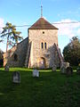 The church seen from the road

References
- Key Statistics; Quick Statistics: Population Density United Kingdom Census 2011 Office for National Statistics Retrieved 10 May 2014
- GENUKI: Madehurst, SSX Archived 2007-11-30 at the Wayback Machine
- Huon Mallalieu, ‘Forster , (Emma Judith) Mary (1853–1885)’, Oxford Dictionary of National Biography, Oxford University Press, 2004 accessed 31 Jan 2015
- "Home". madehurstcricketclub.org.
External links
This West Sussex location article is a stub. You can help Wikipedia by expanding it. |
Другой контент может иметь иную лицензию. Перед использованием материалов сайта WikiSort.org внимательно изучите правила лицензирования конкретных элементов наполнения сайта.
WikiSort.org - проект по пересортировке и дополнению контента Википедии