world.wikisort.org - United_Kingdom
Llandough (/lænˈdɒk/; Welsh: Llandochau Fach [ɬan'doːχaɨ vaχ]) is a village, community and electoral ward in the Vale of Glamorgan (Welsh: Bro Morgannwg), Wales, approximately 2.3 miles (3.7 km) south west of Cardiff city centre, and approximately 1.3 miles (2 km) north west of Penarth.
Llandough
| |
|---|---|
| Village | |
 | |
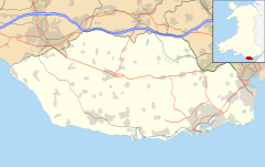 Llandough Location within the Vale of Glamorgan | |
| Area | 1.6176 km2 (0.6246 sq mi) |
| Population | 1,977 (2011)[1] |
| • Density | 1,222/km2 (3,160/sq mi) |
| OS grid reference | ST1685372975 |
| Community | |
| Principal area |
|
| Ceremonial county |
|
| Country | Wales |
| Sovereign state | United Kingdom |
| Post town | Penarth |
| Postcode district | CF64 |
| Police | South Wales |
| Fire | South Wales |
| Ambulance | Welsh |
| UK Parliament |
|
| Senedd Cymru – Welsh Parliament |
|
Toponymy
Llandough is an anglicisation of the Welsh placename Llandochau Fach, which as a combination of the words Llan – meaning church, and Dochau – Sant (Saint in English) Dochau/Dochdwy, followed by Bach – meaning small (However, due to Welsh mutation this is changed to Fach).
History
Excavations have shown that the village's history goes back as far as the Roman occupation of Wales.
Until the mid-1960s, Llandough was a small farming and quarrying village but experienced an expansion involving the building of a large number of houses, a primary school, and a block of six shopping units. However, these shops have now been demolished.
There were around six thatched cottages in the village around 1960, but only one now remains – Pound Cottage.
Llandough became a separate community from Penarth in 1982, though its residents retained a right to be buried in Penarth Cemetery at the same cost until 2007.[2]
St Dochdwy's Church
Llandough was long believed to be one of the main ecclesiastical centres in south east Wales, and was the site of a monastic community known as Bangor Dochau, by St Dochau in the 5th century. Evidence to support this claim was found when the excavations of the Roman villa revealed post-Roman burials, and also during another excavation in 1994, when the remains of over 800 individual burials, all dating from the 4th century to the 12th century AD were revealed.
The monastery became defunct in around the early 11th century,[3] however the site continued in use as a parish church.
The first permanent church building was built in the 12th century, was restored in the 18th century, and remained in use until 1820. The original church was replaced in the 19th century by the Llandaff diocesan architects, Prichard and Seddon. However, this church was deemed too small for the growing population of the village and was replaced after 40 years of service by the current church. The first for the 19th century churches was dismantled and re-erected at Leckwith, where it was re-dedicated to St James. The building has since been converted into a pair of houses.
The current St Dochdwy's Church was built in 1866. It was designed by architect Samuel Charles Fripp of Bristol, and built by David Jones of Penarth for a cost of £2,600.
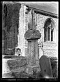
A Celtic stone cross dating back to the 10th or 11th century still stands in the churchyard today. The stone includes an inscription IRBICI, which means “[the stone] of Irbic”, but nothing is known of this person or exactly why the cross was erected. The cross has been mutilated at the top but otherwise is complete. The monument is made of Sutton stone and measures 9 foot 9 inches by 2 foot 3 inches. Renovation work was carried out on the cross in July 2013.[4] A replica can be seen at the National Museum of Wales.[5]
To the west of the church are three fragmentary components of a well-fortified house dating from the 1420s or 1430s,[6] believed to have been built by John de Van.
 St Dochdwy's Church – present day
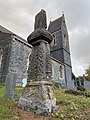 Irbic Cross – present day
 Irbic Cross – present day


Great House Farm
Great House Farm previously stood alongside St Dochdwy's church, and was the site of a Celtic monastery and a missionary centre.
The remains of a soldier and his horse were found under the floor of the dining room when work to replace the stone floor with timber was undertaken. It is believed that there may have been a battle on the site and the soldier was buried where he lay in his armour. His remains were re-buried in St Dochdwy's churchyard and his visor and lance are now in the National Museum of Wales. A petition for the preservation of the farm was signed by 1,700 in 1974.
The farm was opened on occasions for locals, schoolchildren, and visitors to learn about how people lived in the past, how they made dried pork, cheese, butter, beer, and sent sheep's wool to the woollen mill on Leckwith Hill for spinning into yarn. A cheese drying room was hollowed out of a solid wall. There was also a bedroom where travelling monks from earlier centuries would have taken their rest. Guglielmo Marconi slept here in a four poster bed whilst working on his wireless telegraphy experiments between Lavernock Point and Flat Holm.
The farm was the home of Mr John Williams' family several generations. It was demolished on the 6th of December 1988 by British Petroleum Pension Funds following a 33-year dispute over ownership. The site is now mostly vacant and overgrown, awaiting housing development. Housing was built on what was once the fields of Great House Farm in the 1960s, as well as the current Llandough primary school, which was opened by the Rt Hon James Callaghan, MP for Cardiff, on the 16th of October 1970.[7]


Roman Villa
The site of a Roman villa was uncovered in 1979 when the Housing Association began work for blocks of flats. The Glamorgan and Gwent Archaeological Trust started excavations with the help of interested individuals. There were indications that the villa stood on the site between the second half of the 2nd century and the middle of the 4th century. The buildings were built of mortar, the roofs of red pottery tiles and pennant sandstone, the walls rendered will plaster, and the floors consisted of bricked and crushed tiles. A well persevered sunken bath was also found in the main living quarters.
A skeleton, skull, and bones were found on the site, remains of a Romano-British family, possibly farmers.
A last minute bid to save the villa was unsuccessful and the flats of Corinthian Close and Tuscan Close proceeded to be built.[7]
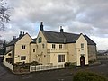
Barons Court
Baron's Court, originally known as Cogan Pill, is a late 15th or early 16th-century hall house with later 19th-century additions.[8]
It was built for Sir Mathew Cradock (died 1531) and passed his grandson Sir George Herbert, the first Sherif of Glamorgan (1494 to 1543). His younger son William, who was sheriff in 1552 and 1567 reputedly enlarged the house. It remained in the Herbert family, who also held St Fagans Castle, for many generations, later becoming a farmhouse in 1642 with the grand hall converted to a barn. In 1790 the building was purchased by Lord Bute. Restored and remodelled c 1850 by H S Corbett, relative and agent of the Marquess of Bute, as a house for himself.[9]
Many of the current features of the building date from this restoration, but it is to be noted that it is the only surviving medieval hall building in South Wales still open from floor to roof.[10]
It has since been a Toby Carvery chain restaurant, and is now a pub/restaurant.[11]
 Cogan Pill Hall – A painting from the Framed Works of Art collection at the National Library of Wales
 Barons Court – present day
 Barons Cour – March 2019


Llandough Institute
The Llandough and Leckwith War Memorial Institute was formerly by the Marchioness of Bute in a ceremony on the 11th of November 1924. It was built using donations from families from the two villages. The original hall was replaced 50 years later and formally opened by Sir Cennydd Traherne. Both the original and the current halls have been used for village functions except for during the WWII years when the building was used by the Royal Air Force. An anti-aircraft battery and balloon barrage unit were also situated in the village, and often smoke screen motors were used to throw smoke screens over Cardiff.
The institute was used by the Llandough Scout and Guide Association until they moved to a newly built centre on Lewis Road in 1975.[7]

Rose Cottage
The Baptist congregation of Llandough originally met in Rose Cottage, opposite Lewis Road on Penlan Road.[12]
This picture taken in 1963 shows the derelict Rose cottage. It appears to have been built on much earlier foundation work.
 Derelict Rose Cottage - 1963


The house is no longer standing, but the original garden walls still exist in front of the flats built on site.
Llandough Baptist Church
Built in 1859 as the successor to the Rose Cottage meeting house, the main building was constructed of stone sourced from Llandough quarry and a slate roof, however there was no interior ceiling. A number of extensions and modernisations were made after the appointment of John Garland as part-time minister in 1979.[12]

Lewis Road Terraces
Houses compromising numbers 1, 3, 5 and 7 were built around 1830. The terraced houses were constructed from square cornered limestone, with slate roofs, and store forecourt walls. Originally the windows and doors had flat arches but some of these features have been removed through modernisation.
Between 1830 and 1971, 1 Lewis Road has operated as a village shop, a bakery, a post office, and a grocers.[13]
 A 1908 Ernest T Bush postcard of Llandough Post Office on Lewis Road
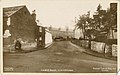

 Lewis Road – present day


The Blacksmith Cottage
Now 89 Penlan Road, the blacksmith's cottage is a single-storey stone building dating from around 1760. It originally had a thatched roof which has since been replaced by a tiled roof. The current kitchen area incorporates the former blacksmith's oven, in the form of a brick dome.[14]
The National School
The stone building on the corner of Penlan Road and Lewis Road was the first National School in the Penarth Area, dating from 1825. It was the initiative of the rector, Rev. James Evans, and was supported by the 2nd Marquess of Bute. At that time the population of Llandough was around 200, and the majority had Welsh as their first language.
The school building was constructed in stone with a slate roof and brick-edged windows and was planned to accommodate between 50 and 60 children. Behind the school a smaller house, 2 Lewis Road, was constructed for the residence of the school teacher.
By 1870 the village's population had increased to over 700, and the school was replaced by a new building opposite in 1872. The new school was planned to accommodate around 125 children and served as an elementary school until January 1941, when it became badly damaged by bombing during World War II.
The national school building is now a private house.[15]
 The National School – Present Day
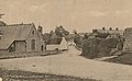 School built in 1872


Pen-Y-Lan House
Now 91 Penlan Road, Pen-Y-Lan house is one of the oldest houses in the village having being built in 1680. Originally the house was a one-up, one-down but has since been extended to the rear, and is now a 3 bedroomed house. The house is built of stone and originally had a thatched roof, but it is now replaced by slate.[16]
The Policeman's House and Old Post Office
Number 18 and 20 Penlan Road were built between 1840 and 1874 in stonework with slate roofs.
Number 20 was the village's police station until around 1954. Its garage incorporated the Air Raid Precautions post during World War II.
Number 18 was the original Post Office for Llandough.[17]

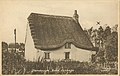
Pound Cottage
Pound Cottage is a grade II listed building and was constructed around 1830 on land belonging to the Bute estate.[18] It is as a two-storey thatched cottage with whitewashed walls.[19] It was formerly the home of the village pound keeper, who was responsible for catching and keeping stray animals. The stone walled pound attached to the building was demolished in 1950.
There have been multiple alterations and additions, including single-storey extensions at each end, both of which are thatched. The cottage is now the last thatched cottage in Llandough.
Pound Cottage served as a sweetshop for some years.


Primrose Cottage
Primrose Cottage was built as three small cottages called Primrose, Moss Rose, and Rosemary in the period 1840–1878. Each cottage was a one-up, one-down with stone spiral staircases.[20]
Y Bwthyn Bach
Also known as The Welsh House and The Little House, the house was constructed from materials left over from the construction of University Hospital Llandough. It was presented as a gift from the people of Wales to the Duke and Duchess of York (then the future King George VI and Queen Elizabeth) in March 1932 for the 6th birthday of Princess Elizabeth.[21] It was transported to the royal family's house, Royal Lodge, in Windsor Great Park near Windsor Castle and has been used as a playhouse by children of the royal family ever since.
The house was designed by Cardiff architect Mr E C Morgan Willmott and had a thatched roof. The house was 24 by 8 foot with ceilings 5 foot high, two thirds the size of a normal house and compromised of a parlour, a kitchen, a bedroom, and a bathroom. The house is decorated throughout and has furniture and fittings to scale.
Demography
The demographic figures date from the United Kingdom Census 2011 are as follows:[22]
| count | % | ||
|---|---|---|---|
| All usual residents | 1,977 | 100.0 | |
| Males | 968 | 49.0 | |
| Females | 1,009 | 51.0 | |
| Lives in a household | 1,950 | 98.6 | |
| Lives in a communal establishment | 27 | 1.4 | |
| Schoolchild or full-time student aged 4 and over at their non term-time address | 26 | - | |
| Area (Hectares) | 161.76 | - | |
| Density (number of persons per hectare) | 12.2 | - | |
| count | % | ||
|---|---|---|---|
| All usual residents | 1,977 | 100 | |
| Age 0 to 4 | 103 | 5.2 | |
| Age 5 to 7 | 53 | 2.7 | |
| Age 8 to 9 | 37 | 1.9 | |
| Age 10 to 14 | 88 | 4.5 | |
| Age 15 | 26 | 1.3 | |
| Age 16 to 17 | 49 | 2.5 | |
| Age 18 to 19 | 28 | 1.4 | |
| Age 20 to 24 | 88 | 4.5 | |
| Age 25 to 29 | 82 | 4.1 | |
| Age 30 to 44 | 427 | 21.6 | |
| Age 45 to 59 | 433 | 21.9 | |
| Age 60 to 64 | 138 | 7.0 | |
| Age 65 to 74 | 246 | 12.4 | |
| Age 75 to 84 | 138 | 7.0 | |
| Age 85 to 89 | 27 | 1.4 | |
| Age 90 and over | 14 | 0.7 | |
| Mean Age | 43.8 | - | |
| Median Age | 45 | - | |
Schools
Llandough currently has one primary school. All together there have been three. In the Victorian era, the school was situated on Penlan Road. Another school was later built, but was bombed in World War II. The current school was built in 1970. The school has approximately 180 pupils, and is one of the feeder schools for Penarth's largest secondary school, St. Cyres.
Parks and Recreation
King George V Playing Field
King George V Playing Field is the main park and recreational area in Llandough. Situated between Lewis Road and Greenway Close it features a football pitch, a multi-use games area, a tennis court, an enclosed children's play area, and car parking.
The multi-use games area was constructed in 2020 and is suitable for a range of activities, including football and basketball. Funding came from the Vale Council's Strong Communities Grant Fund (£45,000), Section 106 contributions from nearby developments (£20,000) and a £20,000 Place for Sport grant from Sports Wales.[23]
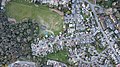 An aerial view of King George V playing field
 One of the tennis courts within the playing fields
 Derelict tennis court that is regularly flooded and is overgrown with reeds and vegetation


Pocket Parks and Village Green
Llandough community council owns and maintains the village green, a village garden on Spencer Drive, and the Book Green pocket park near the junction of Llandough Hill and Penlan Road.[24]

Allotment Gardens
Llandough has a 67 plot allotment site on Corbett Road. The allotments are managed by the community council.
Proposals for a new allotment site on Lewis Road are currently being discussed by the community council. This site was originally purchased for allotments use but demand was low and eventually there were no tenants or demands for plots. However, there are currently 38 names on the waiting list for the Corbett Road allotments site, and a grazing license on the Lewis Road site is due to expire in December 2022.[25]
Health Meadow
Cardiff and Vale University Health Board has plans to develop a 7 field adjacent to University Hospital Llandough into an outdoor wellbeing and healthcare facility.[26]
Transport
Roads
The main road through the village is the B4267. From the junction on Llandough Hill to the Merrie Harrier junction on the A4055 (Barry Road) it is named Penlan Road, and from the Llandough Hill junction forwards it is named Leckwith Road. Llandough Hill connects the village to the A4160 (Penarth Road).
Buses
Llandough is served by 21 bus stops:
| Stop Number | Buses Head | Service Numbers |
|---|---|---|
| Leckwith Road near Rectory Lodge | South East | 95 |
| Leckwith Road near Rectory Lodge | North West | 95 |
| Leckwith Road before Greenway Close | South East | 95 |
| Leckwith Road after Greenway Close | North West | 95 |
| Penlan Road on side of The Institute | South East | 89B, 95 |
| Penlan Road opposite The Institute | North West | 95 |
| Hospital (Stop 1), Penlan Road | South East | 7, 95, 304 |
| Hospital (Stop 2), Penlan Road | North | 89A, 89B, 95 |
| Hospital (Stop 3), Grounds | North West | 7, 95, 304, H95 |
| Hospital (Stop 4), Grounds | North West | 7, 95, 304, H95 |
| Hospital (Stop 5), Grounds | North West | 7, 89B, 95, 304, H95 |
| Hospital (Stop 8), Grounds | South West | 89B |
| Penlan Road after Merrie Harrier | North East | 7, 89A, 95, 304 |
| Barry Road after Merrie Harrier | North West | 93, 95, 304 |
| Dochdwy Road near Dochdwy Road PO | South East | 89A, 89B |
| Dochdwy Road before 41 Dochdwy Road | South | 89A, 89B |
| Dochdwy Road before Vale View Crescent | South West | 89A, 89B |
| Penarth Road opposite Trading Estate | North West | 92, 92B 93, 94, 95 |
| Penarth Road before Llandough Hill | South East | 92, 92B, 93, 94 |
| Penarth Road before Llandough Hill | North West | 89B, 92, 92B, 93, 94, 95 |
| Penarth Road before Barons Court | South East | 92, 92B, 93, 94 |
| Penarth Road opposite Barons Court | North West | 89B, 92, 92B, 93, 94, 95 |
Train
The nearest train station to Llandough is Cogan Station approximately 0.4 miles (0.6 km) away. It can be accessed on foot from most of the village via Cogan Pill Road and crossing the A4055. Services run to Aberdare, Barry Island, Bridgend, Merthyr Tydfil, and Pontypridd, with all services passing through Cardiff Central, operating at 4 trains per hour in each direction.
Bike
There is an OVO bikes (operated by Nextbike) hire station within the grounds of University Hospital Llandough offering electrically assisted bicycles.
Governance
Community Council
The Community Council was established in 1982 and consists of 10 Councillors, a part-time Clerk and two part-time Caretakers.
The council manage Llandough's allotments site, the village fete, and community engagement.
The present chairman of the council (2022/23) is Cllr Lucy Barrowclough.[27]
Vale of Glamorgan Council
Llandough's ward elects a county councillor to the Vale of Glamorgan Council.
The ward is currently represented by Cllr George Carroll (Conservatives).[28]
Welsh Government
Vaughan Gething represents Cardiff South and Penarth in the Senedd (Labour & Co-operative Party), succeeding Lorraine Barrett.
There are four Members of the Senedd also representing the area: Joel James (Conservative), Andrew RT Davies (Conservative), Heledd Fychan (Plaid Cymru), Rhys ab Owen (Plaid Cymru).
Westminster
The MP for Cardiff South and Penarth is Stephen Doughty (Labour & Co-operative Party) who was re-elected on 10 December 2019.
Administrative Boundary
The map below shows the administrative boundary of Llandough.

Gallery
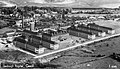 Llandough Hospital
 Llandough Hospital – 1933
 Llandough Hospital – 1933
 Telford's Cottage
 'Brickworks, Llandough' by Charles Byrd, 1950s
 Ex GWR Bench on the village green
 Wooden bus shelter – 5 August 2010
 The Merrie Harrier – 2 August 2010
 Penlan Road – 18 February 2021


External links
- Llandough Community Council Website
- Excavations at Llandough Monastery
- The Llandough Girdle
- Llandough Early Mediaeval Cemetery
- Genuki Llandough Resources
- The Early Medieval Monastic Cemetery at Llandough, Glamorgan
- www.geograph.co.uk : photos of Llandough and surrounding area
- An Early-medieval Monastic Cemetery at Llandough
References
- "Llandough Ward (as of 2011)". Retrieved 6 October 2022.
- "New rule doubles cost of burials". Wales Online. 10 April 2007. Retrieved 16 December 2017.
- "The Early Medieval Monastic Cemetery at Llandough, Glamorgan". Archaeology Data Service. Retrieved 6 October 2022.
- "St Dochdwy's - Parish of Penarth and Llandough". www.parishofpenarthandllandough.co.uk. Retrieved 6 October 2022.
- "Towns and Villages Around Cardiff | Llandough (Penarth)". www.visitoruk.com. Retrieved 6 October 2022.
- Newman, John (1995). Glamorgan. London: Penguin Group. p. 377. ISBN 0-14-071056-6.
- The Glamorgan village book. Glamorgan Federation of Women's Institutes. Newbury: Countryside Books and the GFWI, Port Talbot. 1993. ISBN 1-85306-254-5. OCLC 59959830.
{{cite book}}: CS1 maint: others (link) - Stuff, Good. "Barons Court PH, Llandough, Vale of Glamorgan". britishlistedbuildings.co.uk. Retrieved 6 October 2022.
- "Barons Court" (PDF). Llandough Community Council. Retrieved 6 October 2022.
- Newman, John (1995). Glamorgan : (Mid Glamorgan, South Glamorgan and West Glamorgan). Stephen Hughes, Anthony Ward. London: Penguin Books. ISBN 0-14-071056-6. OCLC 33858574.
- Rowlands, Eve (22 August 2022). "Private dining restaurant with champagne terrace opening at former Toby Carvery". WalesOnline. Retrieved 6 October 2022.
- "The Baptist Church and Rose Cottage" (PDF). Llandough Community Council. Retrieved 6 October 2022.
- "Lewis Road Terraced Houses" (PDF). Llandough Community Council. Retrieved 6 October 2022.
- "The Blacksmith Cottage" (PDF). Llandough Community Council. Retrieved 6 October 2022.
- "The National School No. 2 Lewis Road" (PDF). Llandough Community Council. Retrieved 6 October 2022.
- "Pen-Y-Lan House" (PDF). Llandough Community Council. Retrieved 6 October 2022.
- "The Policeman's House and Old Post Office Numbers 18 and 20 – Penlan Road" (PDF). Llandough Community Council. Retrieved 6 October 2022.
- Stuff, Good. "Pound Cottage, Llandough, Vale of Glamorgan". britishlistedbuildings.co.uk. Retrieved 6 October 2022.
- "Pound Cottage". Coflein. Retrieved 6 October 2022.
- "Primrose Cottage – Present Day" (PDF). Llandough Community Council. Retrieved 6 October 2022.
- "Y Bwthyn Bach, The Little House at Royal Lodge". www.thamesweb.co.uk. Retrieved 6 October 2022.
- "Llandough Ward (as of 2011) - Nomis - Official Census and Labour Market Statistics". www.nomisweb.co.uk. Retrieved 6 October 2022.
- "Work begins on multi-use games area in Llandough". Vale of Glamorgan Council. Retrieved 6 October 2022.
- "Pocket Parks & Village Green - Llandough Community Council". www.llandough-cc.co.uk. Retrieved 6 October 2022.
- "Council Minutes 20 May 2021" (PDF). Llandough Community Council. Retrieved 6 October 2022.
- "Our Health Meadow: A new approach to health care delivery at University Hospital Llandough". Cardiff & Vale Health Charity. 14 April 2021. Retrieved 6 October 2022.
- "Councillors - Llandough Community Council". www.llandough-cc.co.uk. Retrieved 6 October 2022.
- "Councillors". Vale of Glamorgan Council. Retrieved 6 October 2022.
Vale of Glamorgan County Borough | |||||
|---|---|---|---|---|---|
Vale of Glamorgan Council | |||||
| Barry |
|  | |||
| Other towns | |||||
| Communities |
| ||||
| Villages |
| ||||
| Landmarks and listed buildings |
| ||||
| Geography |
| ||||
| Economy |
| ||||
| Transport |
| ||||
| Sport |
| ||||
| Topics |
| ||||
Другой контент может иметь иную лицензию. Перед использованием материалов сайта WikiSort.org внимательно изучите правила лицензирования конкретных элементов наполнения сайта.
WikiSort.org - проект по пересортировке и дополнению контента Википедии