world.wikisort.org - United_Kingdom
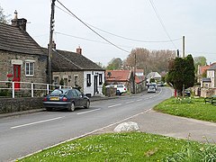
Hutton Magna is a village and civil parish in County Durham, England. Situated 7.6 miles (12.2 km) south east of Barnard Castle. Lying within the historic boundaries of the North Riding of Yorkshire, the village along with the rest of the former Startforth Rural District has been administered with County Durham since 1 April 1974, under the provisions of the Local Government Act 1972. The civil parish also includes the hamlet of Lane Head.[2]
| Hutton Magna | |
|---|---|
 | |
 Hutton Magna Location within County Durham | |
| Population | 194 (2011)[1] |
| OS grid reference | NZ126124 |
| Unitary authority |
|
| Ceremonial county |
|
| Region |
|
| Country | England |
| Sovereign state | United Kingdom |
| Post town | Richmond |
| Postcode district | DL11 |
| Police | Durham |
| Fire | County Durham and Darlington |
| Ambulance | North East |
| UK Parliament |
|
History
The name "Hutton Magna" translates to "large farm on a hill" with the word magna being the Latin word for "large", possibly to distinguish it from the hamlet of Little Hutton to the east.[3]
Known simply as Hutton, the village was recorded in the Domesday Book, with a population of 11 households.[4]
In 1288/9 Margaret de Neville settled the manor of Hutton Magna on herself for life.[5]
In 1870-72 John Marius Wilson's Imperial Gazetteer of England and Wales described Hutton Magna as:
"a village and a township in Teesdale district, and a parish partly also in Richmond district, N. R. Yorkshire. The village stands 1¾ mile S of the river Tees, 4 S by W of Winston r. station, and 6½ SE by E of Barnard-Castle. The township contains also the hamlet of Lane Head, and comprises 1, 510 acres."[6]
Governance
Hutton Magna was part of the local government district of Teesdale from 1974 before it was abolished as part of the 2009 structural changes to local government in England. For the purposes of Durham County Council elections, Hutton Magna is located in the Barnard Castle East ward.
The village lies within the Bishop Auckland parliamentary constituency, which is under the control of the Conservative Party. The current Member of Parliament, since the 2019 general election, is Dehenna Davison.
Community and culture
The parish church of St Mary, a grade II listed building, was rebuilt in 1878, incorporating some features dating back to the 12th century from a former medieval church.[7]
The village's sole public house, The Oak Tree Inn, closed in 2018.[8]
References
- "Parish population 2011". Retrieved 7 July 2015.
- "Lane Head (Hutton Magna) | Co-Curate". co-curate.ncl.ac.uk. Retrieved 31 May 2020.
- Durham County Council, webadmin@durham gov uk (4 November 2016). "Site Details".
{{cite journal}}: Cite journal requires|journal=(help) - "Hutton [Magna] | Domesday Book". opendomesday.org. Retrieved 31 May 2020.
- 'Parishes: Hutton Magna or Hutton Longvilliers', in A History of the County of York North Riding: Volume 1, ed. William Page (London, 1914), pp. 84-86. British History Online http://www.british-history.ac.uk/vch/yorks/north/vol1/pp84-86 [accessed 29 October 2021].
- "History of Hutton Magna, in Teesdale and North Riding | Map and description". www.visionofbritain.org.uk. Retrieved 31 May 2020.
- Historic England. "CHURCH OF ST MARY, Hutton Magna (1121664)". National Heritage List for England. Retrieved 31 May 2020.
- "Popular Teesdale pub and restaurant to close". The Northern Echo. Retrieved 31 May 2020.
External links
![]() Media related to Hutton Magna at Wikimedia Commons
Media related to Hutton Magna at Wikimedia Commons
Другой контент может иметь иную лицензию. Перед использованием материалов сайта WikiSort.org внимательно изучите правила лицензирования конкретных элементов наполнения сайта.
WikiSort.org - проект по пересортировке и дополнению контента Википедии