world.wikisort.org - United_Kingdom
Hollins Lane is a village near the village of Forton, in the Wyre District, in the English county of Lancashire. The village has the Lancaster and Preston Junction Railway running through it but there is no station.
| Hollins Lane | |
|---|---|
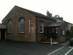
 Church and Post Office, Hollins Lane | |
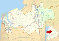
 Hollins Lane Shown within Wyre Borough  Hollins Lane Location within Lancashire | |
| OS grid reference | SD496511 |
| Civil parish |
|
| District |
|
| Shire county |
|
| Region |
|
| Country | England |
| Sovereign state | United Kingdom |
| Post town | PRESTON |
| Postcode district | PR3 |
| Dialling code | 01524 |
| Police | Lancashire |
| Fire | Lancashire |
| Ambulance | North West |
| UK Parliament |
|
Amenities
Hollins Lane has a place of worship, a post office and a pub, the New Holly.
Nearby settlements
Nearby settlements include the town of Garstang, the village of Forton and the hamlet of Shireshead.
Location grid
Transport
For transport there is the M6 motorway and the A6 road nearby.
References
Wikimedia Commons has media related to Hollins Lane.
Текст в блоке "Читать" взят с сайта "Википедия" и доступен по лицензии Creative Commons Attribution-ShareAlike; в отдельных случаях могут действовать дополнительные условия.
Другой контент может иметь иную лицензию. Перед использованием материалов сайта WikiSort.org внимательно изучите правила лицензирования конкретных элементов наполнения сайта.
Другой контент может иметь иную лицензию. Перед использованием материалов сайта WikiSort.org внимательно изучите правила лицензирования конкретных элементов наполнения сайта.
2019-2025
WikiSort.org - проект по пересортировке и дополнению контента Википедии
WikiSort.org - проект по пересортировке и дополнению контента Википедии