world.wikisort.org - United_Kingdom
Caersws (Welsh: Caersŵs; pronounced [kɑːɨrˈsuːs] (![]() listen)) is a village and community on the River Severn, in the Welsh county of Powys (Montgomeryshire) 5 miles (8 km) west of Newtown, and halfway between Aberystwyth and Shrewsbury. It has a station on the Cambrian Line from Aberystwyth to Shrewsbury. At the 2011 Census, the community had a population of 1,586[1] – a figure which includes the settlements of Clatter, Llanwnnog and Pontdolgoch. The village itself had a population of slightly over 800.[2]
listen)) is a village and community on the River Severn, in the Welsh county of Powys (Montgomeryshire) 5 miles (8 km) west of Newtown, and halfway between Aberystwyth and Shrewsbury. It has a station on the Cambrian Line from Aberystwyth to Shrewsbury. At the 2011 Census, the community had a population of 1,586[1] – a figure which includes the settlements of Clatter, Llanwnnog and Pontdolgoch. The village itself had a population of slightly over 800.[2]
Caersws
| |
|---|---|
 The former village church | |
 Caersws Location within Powys | |
| Population | 1,586 (2011) |
| OS grid reference | SO031919 |
| Community |
|
| Principal area | |
| Ceremonial county | |
| Country | Wales |
| Sovereign state | United Kingdom |
| Post town | Caersws |
| Postcode district | SY17 |
| Dialling code | 01650 |
| Police | Dyfed-Powys |
| Fire | Mid and West Wales |
| Ambulance | Welsh |
| UK Parliament |
|
| Senedd Cymru – Welsh Parliament |
|
Etymology
The name is derived from the Welsh placename elements "Caer-" and "Sŵs". "Caer" may be translated as "city" or "fort" and likely refers to the Roman settlement. The derivation of the second element is less certain.
Thomas Pennant and later writers note that the fort was the termination of the Roman Road from Chester (via Meifod), the name of the road was Sarn Swsan or Sarn Swsog and it is thought that the town and the road share their etymology. The meaning of Swsan/Swsog is again, uncertain, but two local traditions hold that this is a personal name, either of a Queen Swswen (a name which may translate as "The Blessed/Pure Kiss") a Celtic leader who is said to have fought a battle in the vicinity around the time of the Roman occupation, or it is named for a Roman lieutenant "Hesus".[3][4][5]
Furthermore, the linguist John Rhys noted that the dialect of Mid-Wales Welsh (Y Bowyseg) was closer to the Gaulish language than its neighbours, and concluded that the area had pre-Roman links to Gaul. This may suggest a link between Caersŵs and the God Esus venerated by the Parisii and Treverii.[6][7]
Other suggested etymologies include the name retaining a Roman-era dedication to Zeus, and the fact that "sws" (not sŵs) can be literally translated to "Kiss" in modern Welsh has led to a number of developing folk etymologies.
History
Caersws was the location of two Roman forts of Roman Wales. Although the Mediolanum of the Antonine Itinerary has since been identified as Whitchurch in Shropshire, Caersws is sometimes identified as the Mediolanum among the Ordovices described in Ptolemy's Geography,[8] although others argue for Llanfyllin[9] or Meifod.[9][10] Further, this second Mediolanum may be identical or distinct from the "Mediomanum" (lit. "Central Hand") mentioned by the Ravenna Cosmography.[8]
Governance
An electoral ward in the same name exists. This ward includes the community of Carno and at the 2011 Census had a population of 2,316.[11]
Buildings
This section does not cite any sources. (September 2022) |
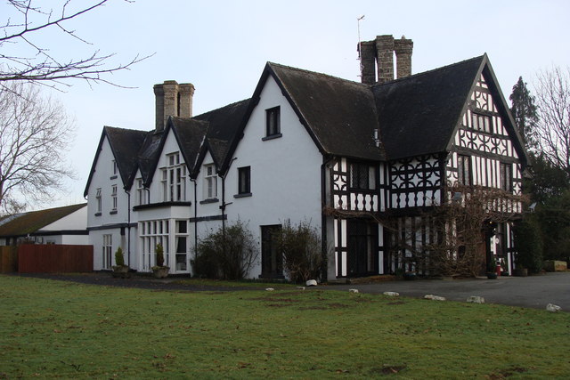
Llanwnnog Church in the community of Caersws is a single-chambered structure, variously considered to date from the 13th or 15th century and restored in 1863. It contains a 15th or 16th century rood screen and loft in Montgomeryshire, a medieval font bowl and one 17th century memorial. Maesmawr Hall was built in the early 19th century.
Sport
Downhill Mountain Biking has flourished in forestry at Henblas farm, to the north of the village, with a number of national races being held there. The current series - The Caersws Cup[12] - began in March 2009.
Cymru Alliance club Caersws F.C. are based in the village, and play their home matches at the Recreation Ground.
Caersws is home to current and past champions of a number of sporting disciplines, leading some to christen it the "Sporting Capital of Wales".[13]
Notable people
- Walter Watkins, former Welsh international footballer was born here.
- Phil Woosnam, former NASL commissioner and capped Welsh footballer.
- Welsh romantic poet John Ceiriog Hughes was stationmaster and manager of the Van Railway from 1868 until his death in 1887. He is buried in the churchyard at Llanwnnog.
Gallery
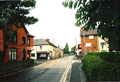 The village centre, complete with Texaco garage and Spar shop in 2010.
 One of Caersws’ four local pubs in 2010.
 The in town level crossing by the Caersws station in 2010.
 A gated village Barrow Crossing/foot crossing in Caersws in 2010.
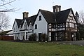 Maesmawr Hall, a grade II* listed building


See also
- Welsh Marches
References
- "Community population 2011". Archived from the original on 4 March 2016. Retrieved 10 November 2015.
- "Local Area Report for Caersws Built-up area (based on 2011 Census)". Nomis - Official Labour Market Statistics. Archived from the original on 5 November 2020. Retrieved 6 April 2022.
- Eddowes, John (1832). The History of Wales; Written originally in British by Caradoc of Llancarvan; Translated into English by Dr. Powell. Shrewsbury. pp. 283–284. Archived from the original on 6 April 2022. Retrieved 7 December 2020.
- Knight, C. (1839). The Penny Cyclopædia of the Society for the Diffusion of Useful Knowledge (Volume 15 ed.). London. p. 363. Archived from the original on 6 April 2022. Retrieved 7 December 2020.
- Lewis, Samuel (1840). A Topographical Dictionary of Wales: Comprising the Several Counties, Cities, Boroughs, Corporate and Market Towns, Parishes, Chapelries, and Townships, with Historical and Statistical Descriptions (Volume 1) (2nd ed.). London.
- Williams, E. W. (30 April 2015). "J.E.Lloyd and his intellectual legacy; the tribes of Wales reconsidered" (PDF): 203. Archived (PDF) from the original on 6 April 2022. Retrieved 1 April 2020.
{{cite journal}}: Cite journal requires|journal=(help) - Rhys J. & Brynmor-Jones D. The Welsh People. London: Unwin. pp. 19–21.
- Roman Britain Organisation. "Mediomanum?" at Roman Britain Archived 2007-04-01 at the Wayback Machine. 2010.
- Williams, Robert. "A History of the Parish of Llanfyllin" in Collections Historical & Archaeological Relating to Montgomeryshire, Vol. III, p. 59 Archived 22 December 2016 at the Wayback Machine. J. Russell Smith (London), 1870.
- Newman, John Henry & al. Lives of the English Saints: St. German, Bishop of Auxerre, Ch. X: "Britain in 429, A. D.", p. 92. Archived 2016-03-21 at the Wayback Machine James Toovey (London), 1844.
- "Ward population 2011". Archived from the original on 26 September 2020. Retrieved 10 November 2015.
- "Archived copy". Archived from the original on 27 August 2009. Retrieved 22 July 2009.
{{cite web}}: CS1 maint: archived copy as title (link) - "Sporty Village Boasts Famous Five at BBC.co.uk". 28 December 2008. Archived from the original on 31 December 2008. Retrieved 28 December 2008.
Literature
- Stephenson D. (2014), The Medieval Borough of Caersws: Origins and Decline, The Montgomeryshire Collections, Vol. 102, 103–109.
External links
- 6 pages of artifacts and documents associated with Caersws and held on Gathering the Jewels the website of Welsh cultural history [permanent dead link]
- www.geograph.co.uk : photos of Caersws and surrounding area

| Authority control |
|
|---|
Другой контент может иметь иную лицензию. Перед использованием материалов сайта WikiSort.org внимательно изучите правила лицензирования конкретных элементов наполнения сайта.
WikiSort.org - проект по пересортировке и дополнению контента Википедии