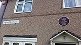
 Plaque showing former home of heavyweight boxing champion Henry Cooper at 120 Farmstead Road, Bellingham, London Borough of Lewisham
 Adolf Street in the Bellingham Estate which was constructed during Adolf Hitler's rise to power as leader of the German Nationalist Socialist Party
world.wikisort.org - United_Kingdom
Bellingham (/ˈbɛlɪŋəm/ BEL-ing-əm) is an area of South East London, England, within the London Borough of Lewisham. It lies south of Catford and north-west of Beckenham, and is part of the Catford postal district (SE6).
This article needs additional citations for verification. (December 2009) |
| Bellingham | |
|---|---|
 St Dunstan's Church, Bellingham | |
 Bellingham Location within Greater London | |
| Population | 14,775 (2011 Census. Ward)[1] |
| OS grid reference | TQ375715 |
| London borough | |
| Ceremonial county | Greater London |
| Region | |
| Country | England |
| Sovereign state | United Kingdom |
| Post town | LONDON |
| Postcode district | SE6 |
| Dialling code | 020 |
| Police | Metropolitan |
| Fire | London |
| Ambulance | London |
| UK Parliament |
|
| London Assembly |
|
History
| Estate name | Area | No of dwellings | Population 1938 | Population density |
|---|---|---|---|---|
| Pre-1914 | ||||
| Norbury | 11 | 218 | 867 | 19.8 per acre (49/ha) |
| Old Oak | 32 | 736 | 3519 | 23 per acre (57/ha) |
| Totterdown Fields | 39 | 1262 | — | 32.4 per acre (80/ha) |
| Tower Gardens White Hart Lane | 98 | 783 | 5936 | 8 per acre (20/ha) |
| 1919–1923 | ||||
| Becontree | 2770 | 25769[lower-alpha 1] | 115652 | 9.3 per acre (23/ha) |
| Bellingham | 252 | 2673 | 12004 | 10.6 per acre (26/ha) |
| Castelnau | 51 | 644 | 2851 | 12.6 per acre (31/ha) |
| Dover House Estate Roehampton Estate | 147 | 1212 | 5383 | 8.2 per acre (20/ha) |
| 1924–1933 | ||||
| Downham | 600 | 7096 | 30032 | 11.8 per acre (29/ha) |
| Mottingham | 202 | 2337 | 9009 | 11.6 per acre (29/ha) |
| St Helier | 825 | 9068 | 39877 | 11 per acre (27/ha) |
| Watling | 386 | 4034 | 19110 | 10.5 per acre (26/ha) |
| Wormholt | 68 | 783 | 4078 | 11.5 per acre (28/ha) |
| 1934–1939 | ||||
| Chingford[lower-alpha 2] | 217 | 1540 | — | 7.1 per acre (18/ha) |
| Hanwell (Ealing) | 140 | 1587 | 6732 | 11.3 per acre (28/ha) |
| Headstone Lane | 142 | n.a | 5000 | |
| Kenmore Park | 58 | 654 | 2078 | 11.3 per acre (28/ha) |
| Thornhill (Royal Borough of Greenwich) | 21 | 380 | 1598 | 18.1 per acre (45/ha) |
| Whitefoot Lane (Downham) | 49 | n.a | n.a. | |
Source:
| ||||
According to author and historian Nick Barratt, there was certainly a Saxon community at Bellingham.[2] In 10th century Anglo-Saxon charters, the place is referred to as Beringaham and by 1198 the name had changed from starting with 'Ber' to 'Bel' through Norman influence.[3] Some streets in Bellingham are named after the Saxon king Alfred the Great and his extended family: King Alfred Avenue, Elfrida Crescent and Arnulf Street.
The area was farmland for centuries, but the London County Council developed a cottage estate from 1919 to 1923 on the former Bellingham Farm,[4] and was completed before World War II.[5] The estate is bordered to the east and west by railway lines running south from Catford. Along the south it is bordered by Southend Lane, the A2218 main road. The River Ravensbourne runs through Bellingham, although it is either underground or part of a man-made section of the river. The Prime Meridian passes to the east of Bellingham.
Amenities
Randlesdown Road serves as a mini 'High Street' for Bellingham providing a local supermarket, men's and women's hair dressers, dry cleaner, off licence, news agent, fish and chip shop, The Fellowship pub and cinema, various takeaways and a gym (situated on Bellingham playing fields). It is known for being a very multicultural area.
Bellingham Green is a hexagonal public park at the centre of the estate.
Transport
Bellingham railway station serves the area with services to Kentish Town (London Blackfriars on Sundays) via Catford and to Sevenoaks via Swanley. Bellingham is served by many Transport for London buses connecting it with areas including Beckenham, Biggin Hill, Bromley, Catford, Central London, Greenwich, Shoreditch, Camberwell, Bermondsey, Deptford, Elephant & Castle, Brockley, Lewisham, New Cross, Orpington, Peckham and Woolwich.
Pre-school and primary education
Pre-schools, nurseries and kindergartens include Kindergarten Forest Hill in Bellingham Green and Umbrella House Day Nursery. Primary schools in Bellingham include Athelney Primary School, St Augustines and Elfrida Primary School.
Image gallery
Bellingham Estate, London Borough of Lewisham


References
- "Lewisham Ward population 2011". Neighbourhood Statistics. Office for National Statistics. Retrieved 13 October 2016.
- Barratt, Nick (2012). Greater London - The Story of the Suburbs. Vauxhall Bridge Road, London: Random House. p. 512. ISBN 9781847945327.
- "Bellingham, Lewisham". hidden-london.com. Retrieved 4 November 2021.
- Lewisham Archive https://boroughphotos.org/lewisham/bellingham-farm-7/
- "Lower Sydenham and Bell Green Vision Study - Baseline Appraisal" (PDF). Lewisham London Borough Council. 18 December 2020: 13. Retrieved 3 October 2022.
{{cite journal}}: Cite journal requires|journal=(help)
| Districts |   | |
|---|---|---|
| Attractions |
| |
| Parks and open spaces |
| |
| Constituencies |
| |
| Rail stations | ||
| Other topics |
| |
| ||
Текст в блоке "Читать" взят с сайта "Википедия" и доступен по лицензии Creative Commons Attribution-ShareAlike; в отдельных случаях могут действовать дополнительные условия.
Другой контент может иметь иную лицензию. Перед использованием материалов сайта WikiSort.org внимательно изучите правила лицензирования конкретных элементов наполнения сайта.
Другой контент может иметь иную лицензию. Перед использованием материалов сайта WikiSort.org внимательно изучите правила лицензирования конкретных элементов наполнения сайта.
2019-2026
WikiSort.org - проект по пересортировке и дополнению контента Википедии
WikiSort.org - проект по пересортировке и дополнению контента Википедии