world.wikisort.org - Ukraine
The Komunarskyi District (Ukrainian: Комунарський район, Komunars'kyi raion) is one of seven administrative urban districts (raions) of the city of Zaporizhzhia, located in southern Ukraine. Its population was 139,222 in the 2001 Ukrainian Census,[3] and 134,465 as of 2012[update].[2]
Komunarskyi District
Комунарський район | |
|---|---|
Urban district | |
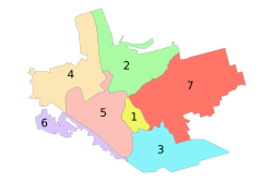 Administrative map of Zaporizhzhia; the Komunarskyi District is indicated by the number 3. | |
 Komunarskyi District Location of the urban district on a map of Zaporizhzhia Oblast. | |
| Coordinates: 47°46′37″N 35°11′21″E | |
| Country | |
| Municipality | Zaporizhzhia Municipality |
| Established | 6 April 1977 |
| Government | |
| • Chairman | Vasyl Yakovenko[1] |
| Area | |
| • Total | 61 km2 (24 sq mi) |
| Population (2012)[2] | |
| • Total | |
| Time zone | UTC+2 (EET) |
| • Summer (DST) | UTC+3 (EEST) |
| Postal index | 330104 |
| Area code | +380 61 |
| KOATUU | 2310136700 |
| Website | w1 |
The raion contains the informal Pivdennyi (Southern) and Kosmichnyi (Cosmic) residential neighborhoods within its boundaries.
Geography
The Komunarskyi District is named after the former Komunar factory (currently, the Zaporizhzhia Automobile Building Plant) which is located within the district's boundaries. The district is located in the southeastern portion of the city, on the left-bank of the Dnipro River, just north of the urban-type settlement of Balabyne, Zaporizhzhia Oblast. Its total area is 61 km2 (24 sq mi).[4]
History
On 6 April 1977, the Komunarskyi District was established out of a portion of the Zhovtnevyi District by a decree of the Presidium of the Verkhovna Rada of the Ukrainian Soviet Socialist Republic (No.1901-ІХ).[4]
References
- "Komunarskyi District". Official portal (in Ukrainian). Site of the Zaporizhzhia City Government. Retrieved 19 January 2015.
- "Number of the population of the City of Zaporizhzhia" (PDF) (in Ukrainian). State Statistics Service of Ukraine in Zaporizhzhia Oblast. 20 June 2012. Retrieved 19 January 2015.
- "Komunarskyi District, Zaporizhzhia Oblast, City of Zaporizhzhia". Regions of Ukraine and their Structure (in Ukrainian). Verkhovna Rada of Ukraine. Archived from the original on 4 March 2016. Retrieved 19 January 2014.
- "Passport of the Komunarskyi District of the City of Zaporizhzhia". Official portal (in Ukrainian). Site of the Zaporizhzhia City Government. Archived from the original on 20 January 2015. Retrieved 19 January 2015.
External links
- "Main". Official portal (in Ukrainian). Site of the Zaporizhzhia City Government. Retrieved 19 January 2015.
- "Pages of history of the Komunarskyi District" (in Ukrainian). Territorial Department of Education, Youth, and Sports of the Komunarskyi Raion. Retrieved 19 January 2015.
Administrative center: Zaporizhzhia | ||
| Raions |
| |
| Hromadas | ||
| Cities | ||
| Urban-type settlements | ||
This article about a location in Zaporizhzhia Oblast is a stub. You can help Wikipedia by expanding it. |
Другой контент может иметь иную лицензию. Перед использованием материалов сайта WikiSort.org внимательно изучите правила лицензирования конкретных элементов наполнения сайта.
WikiSort.org - проект по пересортировке и дополнению контента Википедии