world.wikisort.org - Ukraine
The Zavodskyi District (Ukrainian: Заводський район, Zavods'kyi raion) is one of seven administrative urban districts (raions) of the city of Zaporizhzhia, located in southern Ukraine. Its population was 60,390 in the 2001 Ukrainian Census,[3] and 52,191 as of 2012[update].[2]
Zavodskyi District
Заводський район | |
|---|---|
Urban district | |
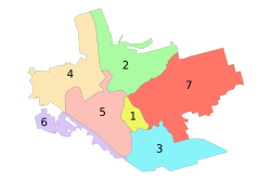 Administrative map of Zaporizhzhia; the Zavodskyi Raion is indicated by the number 2. | |
 Zavodskyi District Location of the urban district on a map of Zaporizhzhia Oblast. | |
| Coordinates: 47°53′50″N 35°11′35″E | |
| Country | |
| Municipality | Zaporizhzhia Municipality |
| Established | 23 May 1969 |
| Government | |
| • Chairman | Volodymyr Biriuk[1] |
| Area | |
| • Total | 56 km2 (22 sq mi) |
| Population (2012)[2] | |
| • Total | |
| Time zone | UTC+2 (EET) |
| • Summer (DST) | UTC+3 (EEST) |
| Postal index | 330600 |
| Area code | +380 61 |
| KOATUU | 2310136600 |
| Website | w1 |
Geography
The Zavodskyi District is named in such a way due to the fact that a large amount of the city's factories are located within its boundaries. The district is located in the northern portion of the city, on the left-bank of the Dnipro River. Its total area is 56 km2 (22 sq mi).[4]
History
On 23 May 1969, the Zavodskyi District was established out of a portion of the Ordzhonikidzevskyi District by a decree of the Presidium of the Verkhovna Rada of the Ukrainian Soviet Socialist Republic (No.1901-ІХ).[4]
Gallery
 Industry
 Industry
 View of the district from the right-bank


References
- "Zavodskyi District". Official portal (in Ukrainian). Site of the Zaporizhzhia City Government. Retrieved 25 January 2015.
- "Number of the population of the City of Zaporizhzhia" (PDF) (in Ukrainian). State Statistics Service of Ukraine in Zaporizhzhia Oblast. 20 June 2012. Retrieved 25 January 2015.
- "Zavodskyi District, Zaporizhzhia Oblast, City of Zaporizhzhia". Regions of Ukraine and their Structure (in Ukrainian). Verkhovna Rada of Ukraine. Retrieved 25 January 2014.
- "Passport of the Zavodskyi District of the City of Zaporizhzhia". Official portal (in Ukrainian). Site of the Zaporizhzhia City Government. Retrieved 25 January 2015.
External links
- "Main". Official portal (in Ukrainian). Site of the Zaporizhzhia City Government. Retrieved 25 January 2015.
Administrative center: Zaporizhzhia | ||
| Raions |
| |
| Hromadas | ||
| Cities | ||
| Urban-type settlements | ||
This article about a location in Zaporizhzhia Oblast is a stub. You can help Wikipedia by expanding it. |
Другой контент может иметь иную лицензию. Перед использованием материалов сайта WikiSort.org внимательно изучите правила лицензирования конкретных элементов наполнения сайта.
WikiSort.org - проект по пересортировке и дополнению контента Википедии