world.wikisort.org - Sweden
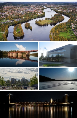
Skellefteå (Swedish: [ɧɛˈlɛ̌ftɛɔ], locally [ʂɛˈlɛ̌ftɛ] (![]() listen)) is a city in Västerbotten County, Sweden. It is the seat of Skellefteå Municipality, which had 73,246 inhabitants in 2021.[2]
listen)) is a city in Västerbotten County, Sweden. It is the seat of Skellefteå Municipality, which had 73,246 inhabitants in 2021.[2]
This article needs additional citations for verification. (April 2012) |
Skellefteå | |
|---|---|
 Skellefteå in images | |
 Coat of arms | |
| Nickname(s): Schtaan, Guldstaden (Goldtown), Skellhell[1] | |
 Skellefteå  Skellefteå | |
| Coordinates: 64°45′N 20°57′E | |
| Country | Sweden |
| Province | Västerbotten |
| County | Västerbotten County |
| Municipality | Skellefteå Municipality |
| Area | |
| • City | 21.74 km2 (8.39 sq mi) |
| Population (31 December 2010)[2] | |
| • City | 36,395 |
| • Density | 1,507/km2 (3,900/sq mi) |
| • Urban | 73,246 |
| Time zone | UTC+1 (CET) |
| • Summer (DST) | UTC+2 (CEST) |
| Area code | +46 0910 |
The city is historically industrial, with mining being a large part of that industry, especially for gold, leading to the city being nicknamed Guldstaden ("gold town"). Politically, Skellefteå is a Social Democratic stronghold. The city is a well-known ice hockey town, with its main team Skellefteå AIK playing in the Swedish top division: the SHL, which they have won on several occasions; most recently in 2014.
The city was incorporated in 1845 and grew to its current population size in the 1950s and 1960s, growing only slowly since. It is the second largest city in Västerbotten after Umeå and is located roughly halfway between it and Luleå. The Skellefte River passes through the city and it is located around 15 kilometres (9.3 mi) from the Bothnian Bay open sea. Skellefteå is served by Skellefteå Airport, IATA airport code SFT but locally known as Falmark because of the village nearby, also around 15 kilometres (9.3 mi) from the city centre to the south.
History

The name Skellefteå is recorded to having been spelled as Skelepht in 1327. [citation needed] On Carta marina the name is spelt Skellitta. The origin of the name remains unknown, but is assumed to be of Sami origin.
From the 14th century on, attempts were made to Christianize Skellefteå. A parish was formed and a church built. However, for the most part, the entire large Northern Swedish territory of Norrland was not Christianized until several hundred years after the rest of Sweden, and many northern areas such as Skellefteå remained unexplored well past the Middle Ages.
Not before the very end of the 17th century did the indigenous Sami people of Northern Sweden begin turning to Christianity, much due to the efforts by the Northern Swedish superintendent Mathias Steuchius, who worked hard to accomplish this. Several Sami priests were killed for this reason.
Eventually, the reason for the sudden awakened interest towards Skellefteälven and the surrounding areas was the great northern fishing grounds of salmon. The increased demand for fish was sparked by a stricter enforcement of the annual month-long fasting by the Catholic Church, whereby meat was substituted by fish. [citation needed]
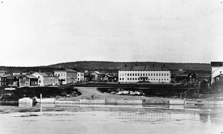
The actual city of Skellefteå is one of the youngest cities of Norrland. It was founded in 1845 by the vicar Nils Nordlander.
Today
In the 20th century, Skellefteå evolved to an industrial and mining city and many wooden houses were demolished to make room for brick buildings.[citation needed] Skellefteå is now trying to become a leading city in education with the construction of Floraskolan, a school that mostly focuses on entrepreneurial learning.[3]
It will become the home of a massive battery plant made by Northvolt by circa 2023.[4]
The largest private employer in Skellefteå is the mining company Boliden AB, with about 1,200 employees. The mine's copper ore contains particles of gold, silver and platinum. Skellefteå is still referred to as the "Goldtown".[by whom?]
During the 1990s, the computer industry flourished, subsidiaries of Ericsson and Tieto Enator becoming important employers.
Climate
Skellefteå is transitioning from a subarctic climate (Dfc) to continental with mild summers and cold, snowy winters. In the 21st century the climate has more resembled the latter. The climate is somewhat moderated by the Bothnia Bay, although maritime effects are limited, ensuring very warm summer temperatures for a coastal area so far north.
| Climate data for Skellefteå Airport (2006–2020 averages, extremes 1970–1992 & 2006–2020 & snow depth from Kusmark) | |||||||||||||
|---|---|---|---|---|---|---|---|---|---|---|---|---|---|
| Month | Jan | Feb | Mar | Apr | May | Jun | Jul | Aug | Sep | Oct | Nov | Dec | Year |
| Record high °C (°F) | 8.5 (47.3) |
10.2 (50.4) |
15.1 (59.2) |
21.5 (70.7) |
29.2 (84.6) |
34.0 (93.2) |
32.4 (90.3) |
30.7 (87.3) |
23.3 (73.9) |
20.3 (68.5) |
12.5 (54.5) |
10.2 (50.4) |
34.0 (93.2) |
| Mean maximum °C (°F) | 4.3 (39.7) |
4.8 (40.6) |
8.8 (47.8) |
14.6 (58.3) |
23.8 (74.8) |
27.1 (80.8) |
28.0 (82.4) |
26.4 (79.5) |
20.0 (68.0) |
13.7 (56.7) |
7.9 (46.2) |
5.3 (41.5) |
29.3 (84.7) |
| Average high °C (°F) | −4.0 (24.8) |
−3.5 (25.7) |
1.6 (34.9) |
7.1 (44.8) |
13.7 (56.7) |
18.6 (65.5) |
21.2 (70.2) |
19.6 (67.3) |
14.2 (57.6) |
6.8 (44.2) |
1.6 (34.9) |
−0.9 (30.4) |
8.0 (46.4) |
| Daily mean °C (°F) | −7.8 (18.0) |
−7.8 (18.0) |
−3.1 (26.4) |
2.4 (36.3) |
8.5 (47.3) |
13.5 (56.3) |
16.4 (61.5) |
14.9 (58.8) |
10.1 (50.2) |
3.7 (38.7) |
−1.2 (29.8) |
−4.3 (24.3) |
3.8 (38.8) |
| Average low °C (°F) | −11.6 (11.1) |
−12.0 (10.4) |
−7.8 (18.0) |
−2.3 (27.9) |
3.2 (37.8) |
8.4 (47.1) |
11.6 (52.9) |
10.2 (50.4) |
6.0 (42.8) |
0.6 (33.1) |
−4.0 (24.8) |
−7.6 (18.3) |
−0.4 (31.2) |
| Mean minimum °C (°F) | −25.3 (−13.5) |
−25.3 (−13.5) |
−21.0 (−5.8) |
−9.7 (14.5) |
−4.0 (24.8) |
0.8 (33.4) |
6.0 (42.8) |
3.5 (38.3) |
−1.3 (29.7) |
−8.2 (17.2) |
−14.4 (6.1) |
−19.3 (−2.7) |
−28.7 (−19.7) |
| Record low °C (°F) | −35.3 (−31.5) |
−36.9 (−34.4) |
−32.5 (−26.5) |
−18.4 (−1.1) |
−6.6 (20.1) |
−1.7 (28.9) |
3.2 (37.8) |
−1.9 (28.6) |
−6.1 (21.0) |
−18.1 (−0.6) |
−27.7 (−17.9) |
−37.1 (−34.8) |
−37.1 (−34.8) |
| Average precipitation mm (inches) | 44.3 (1.74) |
34.3 (1.35) |
31.8 (1.25) |
29.4 (1.16) |
44.9 (1.77) |
58.7 (2.31) |
71.2 (2.80) |
62.1 (2.44) |
64.2 (2.53) |
61.6 (2.43) |
52.2 (2.06) |
58.0 (2.28) |
612.7 (24.12) |
| Average extreme snow depth cm (inches) | 47 (19) |
58 (23) |
61 (24) |
45 (18) |
3 (1.2) |
0 (0) |
0 (0) |
0 (0) |
0 (0) |
6 (2.4) |
15 (5.9) |
35 (14) |
67 (26) |
| Source 1: SMHI Open Data for Skellefteå Airport, precipitation[5] | |||||||||||||
| Source 2: SMHI Open Data for Skellefteå Airport, temperature[6] | |||||||||||||
Industry
- Boliden AB, a big mining and smelting company
- Skellefteå Kraft, largest power company in Skellefteå
- Northvolt, lithium-ion battery cell manufacturing company[7]
Sports
- Skellefteå AIK, an ice hockey team in the highest Swedish league, Swedish Hockey League(SHL). 1978, 2013 and 2014 Swedish Champions.
- Morön BK, football club playing in Division 2 Norrland
- Skellefteå FF, football club playing in Division 2 Norrland
- Sunnanå SK, women's football (soccer)
- The Skellefteå Kraft Grandmaster Chess Cup 1999, one of the strongest all Swedish chess tournaments was won by IGM (International Grandmaster (chess)) Ulf Andersson. The event took place from March 26 – April 4, 1999. An international chess tournament, the final of the two-year World Cup series was held in Skellefteå from August 12 to September 3, 1989. The final sixteen grandmasters participating included three former World Chess Champions Garry Kasparov, Anatoly Karpov and Mikhail Tal.[8] The activities organized around the World Cup final included two performances in Skellefteå of Chess (musical), with music by Benny Andersson and Björn Ulvaeus of the pop group ABBA.[9][10][circular reference]
Notable people
People
Sportspeople
- Anders Andersson, ice hockey player
- Johan Alm, ice hockey player
- Viktor Arvidsson, ice hockey player for the Los Angeles Kings
- Johan Backlund, ice hockey player
- Evy Berggren, Gymnast, Olympic and World Champion
- Filip Berglund, ice hockey player
- Niclas Burström, ice hockey player
- Robert Dahlgren, racing driver
- Jimmie Ericsson, ice hockey player
- Jan Erixon, ice hockey player
- Tim Erixon, ice hockey player
- Toini Gustafsson-Rönnlund, skier
- Filip Gustavsson, ice hockey goaltender
- Jonathan Hedström, ice hockey player
- Adam Larsson, ice hockey player for the Seattle Kraken
- Oscar Lindberg, ice hockey player for the Vegas Golden Knights
- Mats Lindgren, ice hockey player
- Joakim Lindström, ice hockey player
- Gustaf Lindvall, ice hockey player
- Arvid Lundberg, ice hockey player
- Hanna Marklund, football player
- Hardy Nilsson, ice hockey player and later coach
- Joakim Nyström, tennis player
- Marcus Pettersson, ice hockey player for the Pittsburgh Penguins
- David Rundblad, ice hockey player
- Patrik Wallón, ice hockey player
- Adam Wilsby, ice hockey player
Other
- Erik Normark, YouTuber[11] and Naturalist
- Per Olov Enquist, writer
- Tore Frängsmyr, historian
- Ingrid García-Jonsson, Spanish-Swedish actress
- Peter Haber, actor
- Andreas "Vintersorg" Hedlund, musician
- Helena Helmersson, CEO of H&M since 2020
- Thomas Idergard, political commentator
- Stieg Larsson, writer
- Stig Larsson, writer
- David Lindgren, musician
- Anna Nordlander, painter
- Victoria Silvstedt, supermodel
- Henning Sjöström, lawyer
- Margot Wallström, former first Vice President of the European Commission and current Special Representative on Sexual Violence in Conflict with the UN. Foreign Secretary of Sweden 2014–2019
Artists
- Moon Safari, a symphonic rock band.
- The Wannadies, an alternative rock band formed in 1988.
- Vintersorg, a metal band.
- Amber Oak, a pop-rock band.
- Black Bonzo (2003-2011) and Gin Lady (2012-present), progressive-rock bands
See also
References
- https://web.archive.org/web/20050802111949/http://lokalhistoria.skelleftea.org/
- Some material has been translated and incorporated from sv:Skellefteå
- "Skellhell inte så illa som du tror". March 2011. Archived from the original on 20 June 2013. Retrieved 7 March 2014.
- "Tätorternas landareal, folkmängd och invånare per km2 2005 och 2010" (in Swedish). Statistics Sweden. 14 December 2011. Archived from the original on 27 January 2012. Retrieved 10 January 2012.
- Kommun, Skellefteå (2019-10-02). "Presentation av Floraskolan och Florahallen". www.skelleftea.se (in Swedish). Retrieved 2019-11-09.
- plats, Skellefteå se-Ge idéerna (2018-01-30). "Etablering av batterifabrik". portal.skelleftea.se (in Swedish). Archived from the original on 2020-10-06. Retrieved 2019-11-09.
- "Open Data for Skellefteå" (in Swedish). Swedish Meteorological and Hydrological Institute. Retrieved 7 March 2021.
- "Open Data for Skellefteå" (in Swedish). Swedish Meteorological and Hydrological Institute. Retrieved 7 March 2021.
- Milne, Richard; Hall, Ben (2019-12-02). "Europe First: how Brussels is retooling industrial policy". www.ft.com. Retrieved 2020-03-09.
- Mark Crowther. "The Week In Chess 233". London Chess Center. Retrieved 2019-06-10.
- suentus po 147. "Skelleftea World Cup 1989". chessgames.com. Retrieved 2019-06-18.
- Invalidname. "Chess (musical)". en.wikipedia.org. Retrieved 2019-06-18.
- "Erik Normark - YouTube". www.youtube.com. Retrieved 2022-08-05.
External links
![]() Media related to Skellefteå at Wikimedia Commons
Media related to Skellefteå at Wikimedia Commons
- Skellefteå – Official site
- Tourist in Skellefteå – Tourist information in Swedish, English and German languages
Municipalities and seats of Västerbotten County | ||
|---|---|---|
| Municipalities | ||
| Municipal seats | ||
| ||
Authority control | |
|---|---|
| General |
|
| National libraries | |
| Other |
|
На других языках
[de] Skellefteå
Skellefteå [.mw-parser-output .IPA a{text-decoration:none}ɧɛˈlɛftə] ist eine Stadt in der schwedischen Provinz Västerbottens län und der historischen Provinz Västerbotten. Sie ist Hauptort der gleichnamigen Gemeinde.- [en] Skellefteå
[ru] Шеллефтео
Шелле́фтео[1] (швед. Skellefteå) — город на северо-востоке Швеции, в лене Вестерботтен, на реке Шеллефтеэльвен. Центр одноимённой коммуны. Через город проходит европейский автомобильный маршрут E04. В 17 км к югу находится аэропорт Шеллефтео. В городе расположены металлургические предприятия компании Boliden AB (шв.), гидроэлектростанция компании Skellefteå Kraft (шв.), компания Tieto.Другой контент может иметь иную лицензию. Перед использованием материалов сайта WikiSort.org внимательно изучите правила лицензирования конкретных элементов наполнения сайта.
WikiSort.org - проект по пересортировке и дополнению контента Википедии