world.wikisort.org - Spain
Sa Pobla (Catalan pronunciation: [sə ˈpɔbːlə]) is a small municipality in the district of Raiguer on Majorca, one of the Balearic Islands. It is a terminus on the Majorca rail network.
Sa Pobla | |
|---|---|
Municipality | |
 Flag  Coat of arms | |
 Location of Sa Pobla in Mallorca | |
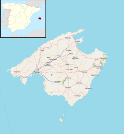 Sa Pobla Location in Majorca  Sa Pobla Sa Pobla (Balearic Islands)  Sa Pobla Sa Pobla (Spain) | |
| Coordinates: 39°46′9″N 3°1′21″E | |
| Country | Spain |
| Autonomous community | Balearic Islands |
| Province | Balearic Islands |
| Comarca | Raiguer |
| Judicial district | Inca |
| Government | |
| • Mayor | Joan Comas Reus |
| Area | |
| • Total | 48.59 km2 (18.76 sq mi) |
| Elevation | 28 m (92 ft) |
| Population (2018)[1] | |
| • Total | 13,026 |
| • Density | 270/km2 (690/sq mi) |
| Demonym(s) | Poblers |
| Time zone | UTC+1 (CET) |
| • Summer (DST) | UTC+2 (CEST) |
| Postal code | 07420 |
The town is in the north of the island. With an area of 48.53 square kilometres (18.74 sq mi), stretching from the Serra de Tramuntana, the Plan and the Bay of Alcúdia. It comprises three very different areas: the Marjal, fertile plains in large part devoted to irrigated agriculture; l 'lagoon, a large area of scenic and ecological value where the streams and San Miguel de Muro (of Almadrà).
References
- Municipal Register of Spain 2018. National Statistics Institute.
External links
Municipalities in the Balearic Islands | ||
|---|---|---|
| Mallorca |
| |
| Menorca |
| |
| Ibiza |
| |
| Formentera | ||
Authority control | |
|---|---|
| General |
|
| National libraries | |
| Other |
|
This article about a location in the Balearic Islands is a stub. You can help Wikipedia by expanding it. |
На других языках
- [en] Sa Pobla
[es] La Puebla
La Puebla[1] (en catalán y oficialmente sa Pobla), antes conocido como Uialfás o La Puebla de Uialfás, es una localidad y municipio español situado en la parte septentrional de Mallorca, comunidad autónoma de las Islas Baleares. Limita con los municipios de Muro, Llubí, Inca, Búger, Campanet, Pollensa y Alcudia.[ru] Ла-Пуэбла
Ла-Пуэ́бла[2][3] (кат. Sa Pobla, исп. La Puebla) — муниципалитет в Испании, входит в провинцию Балеарские острова. Находится на острове Мальорка. Муниципалитет находится в составе района (комарки) Райгер. Занимает площадь 46,03 км². Население — 12 831 человек (на 2010 год).Текст в блоке "Читать" взят с сайта "Википедия" и доступен по лицензии Creative Commons Attribution-ShareAlike; в отдельных случаях могут действовать дополнительные условия.
Другой контент может иметь иную лицензию. Перед использованием материалов сайта WikiSort.org внимательно изучите правила лицензирования конкретных элементов наполнения сайта.
Другой контент может иметь иную лицензию. Перед использованием материалов сайта WikiSort.org внимательно изучите правила лицензирования конкретных элементов наполнения сайта.
2019-2026
WikiSort.org - проект по пересортировке и дополнению контента Википедии
WikiSort.org - проект по пересортировке и дополнению контента Википедии