world.wikisort.org - Spain
The plazas de soberanía (Spanish pronunciation: [ˈplaθas ðe soβeɾaˈni.a], lit. "strongholds of sovereignty")[3] is a term describing a series of Spanish overseas minor territories scattered along the Mediterranean coast bordering Morocco or that are closer to Africa than Europe. This term is used for those territories that have been a part of Spain since the formation of the modern country (1492–1556), as opposed to African territories acquired by Spain during the 19th and early 20th centuries in the Scramble for Africa.
Plazas de soberanía | |
|---|---|
 The plazas de soberanía, plus Ceuta (with Perejil Island) and Melilla on the mainland, and Alboran Island 50 km north of the coast | |
| Country | Spain |
| Government | |
| • Type | Autonomous cities (major plazas de soberanía) De facto unincorporated area[1] under the administration of the Ministry of Defence[2] (minor plazas de soberanía) |
| Area | |
| • Total | 0.59 km2 (0.23 sq mi) |
| Time zone | UTC+01:00 (CET) |
| • Summer (DST) | UTC+02:00 (CEST) |
Historically, a distinction was made between the so-called "major places of sovereignty", comprising the autonomous cities of Ceuta and Melilla, and the "minor places of sovereignty", referring to a number of islands (and a small peninsula) along the coast. In the present, the term refers mainly to the latter.
History

During the Reconquista and mainly following the conquest of Granada in 1492, forces of the Castilian and Portuguese kingdoms conquered and maintained numerous posts in North Africa for trade and as a defence against Barbary piracy.
In August 1415, the Portuguese conquered the city of Ceuta. In 1481, the Papal bull Aeterni regis had granted all land south of the Canary Islands to Portugal. Only this archipelago and the possessions of Santa Cruz de la Mar Pequeña (1476–1524), Melilla (conquered by Pedro de Estopiñán in 1497), Villa Cisneros (founded in 1502 in current Western Sahara), Mazalquivir (1505), Peñón de Vélez de la Gomera (1508), Oran (1509–1708; 1732–1792), Algiers (1510–1529), Bugia (1510–1554), Tripoli (1511–1551), and Tunis (1535–1569) remained as Spanish territory in Africa. Finally, following the independence of Portugal after the end of the Spanish-led Iberian Union, Ceuta was ceded by Portugal to Spain in 1668.[4]
In 1848, Spanish troops conquered the Islas Chafarinas. In the late 19th century, after the so-called Scramble for Africa, European nations had taken over colonial control of most of the African continent. The Treaty of Fez (signed on 30 March 1912) made most of Morocco a protectorate of France, while Spain assumed the role of protecting power over the northern part, Spanish Morocco.[5]
When Spain relinquished its protectorate and recognized Morocco's independence in 1956, it did not give up these minor territories, as Spain had held them well before the establishment of its protectorate.
On 11 July 2002, Morocco stationed six gendarmes on Perejil Island, which was at the time a source of complaint by Spain. The Spanish Armed Forces responded by launching a military operation code-named Operation Romeo-Sierra. The operation was carried out by Spanish commandos of Grupo de Operaciones Especiales. The Spanish Navy and Spanish Air Force provided support; the six Moroccan navy cadets did not offer any resistance and were captured and evicted from the island. It has since been evacuated by both countries.[6]
Physical geography
In addition to Ceuta and Melilla, there are historically three minor plazas de soberanía:
| Territory[lower-alpha 1] | Coordinates | Area (ha) |
|---|---|---|
| Alhucemas Islands | 35°12′54″N 3°53′47″W | 4.6 |
| Isla de Mar | 35°13′3.65″N 3°54′2.69″W | 1.4 |
| Isla de Tierra | 35°12′55.83″N 3°54′8.10″W | 1.7 |
| Peñón de Alhucemas | 35°12′48″N 3°53′21″W | 1.5 |
| Chafarinas Islands | 35°11′N 2°26′W | 52.5 |
| Isla de Isabel II | 35°10′55.77″N 2°25′46.90″W | 15.3 |
| Isla del Rey | 35°10′51.72″N 2°25′24.96″W | 11.6 |
| Isla del Congreso | 35°10′43.90″N 2°26′28.31″W | 25.6 |
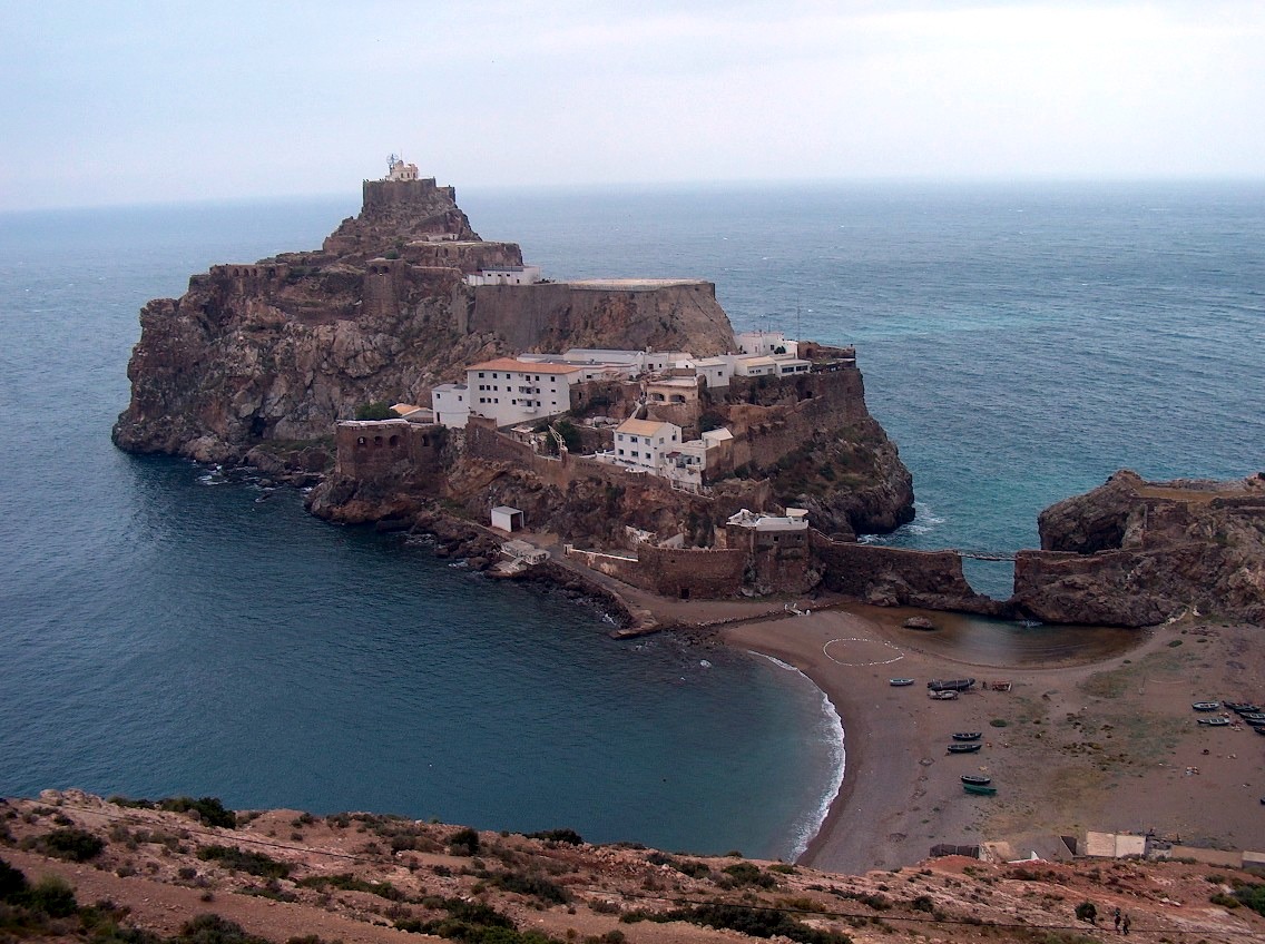
| Peñón de Vélez de la Gomera | 35°10′21.29″N 4°18′2.89″W | 1.9 |
Apart from these, there are two other islands usually considered within the plazas de soberanía.[citation needed] The disputed Perejil Island (Isla Perejil), a small uninhabited islet close to Ceuta, is considered by Spain to be a part of Ceuta and not a territory in its own right.[7] Alboran Island (Isla de Alborán), another small island in the western Mediterranean, about 50 kilometres (31.05 miles) from the African coast and 90 kilometres (55.92 miles) from Europe, is administered as part of the municipality of Almería on the Iberian Peninsula.
Political geography
The plazas de soberanía are small islands and a peninsula off the coast of Morocco (the only peninsula, Peñón de Vélez de la Gomera, was an island until a 1934 storm formed a sand bridge with the mainland). They are guarded by military garrisons and administered directly by the Spanish central government.
Like Ceuta and Melilla, they are a part of Spain, therefore also part of the European Union, and their currency is the euro.
Territorial dispute with Morocco
Morocco claims sovereignty over the plazas de soberanía, including Ceuta and Melilla.
See also
- List of islands of Spain
- List of Spanish colonial wars in Morocco
- Morocco–Spain border
- Nadim al-Maghrebi
- Spanish protectorate in Morocco
Notes
- In order from north to south.
References
- del Valle, Alejandro (20 December 2011). "Ceuta, Melilla, Chafarinas, Vélez y Alhucemas: tomar la iniciativa (ARI)". Real Instituto Elcano (in Spanish). Retrieved 25 March 2020.
- Mariñas Otero, Eugenio (1998). "Las Plazas Menores de soberanía española en África". MILITARIA. Revista de Cultura Militar. (in Spanish). No. 12. Madrid: UCM. Retrieved 25 March 2020.
- ASALE, RAE-; RAE. "plaza #3 | Diccionario de la lengua española". «Diccionario de la lengua española» - Edición del Tricentenario (in Spanish). Retrieved 6 May 2020.
- da Silva, Rui A. M. "Treaties Galore". Olivença - Portugal Livre.
- "Treaty Between France and Spain Regarding Morocco". The American Journal of International Law. 7 (2): 81–99. April 1913. doi:10.2307/2212275. JSTOR 2212275.
- Ceberia Belaza, Monica; Ignacio Cembrero and Miguel González (17 September 2012). "The last remains of the empire". El Pais in English. Madrid. Retrieved 24 September 2012.
- Tremlett, Giles (13 July 2002). "Moroccans seize Parsley Island and leave a bitter taste in Spanish mouths". The Guardian. London. Retrieved 19 May 2014.
When officers from Spain's civil guard police force arrived on a small patrol boat from the nearby Spanish North African enclave of Ceuta three miles away and to which the islet nominally belongs...
Autonomous communities of Spain | ||
|---|---|---|
| Autonomous communities | ||
| Autonomous cities | ||
| Plazas de soberanía | ||
Countries and territories of Africa | |||||||||
|---|---|---|---|---|---|---|---|---|---|
| Sovereign states |
|  | |||||||
States with limited recognition |
| ||||||||
Dependent territories |
| ||||||||
| |||||||||
На других языках
- [en] Plazas de soberanía
[es] Plazas de soberanía
Plazas de soberanía es el término histórico con el que se denominan desde el siglo XIX a los territorios españoles situados en el norte de África, en contraposición a las áreas que constituían el protectorado español de Marruecos. En la actualidad, esta nomenclatura sigue utilizándose para la identificación de las islas y peñones frente a la costa norte de Marruecos, pero no para referirse a las ciudades autónomas de Ceuta y Melilla, que sin embargo recibieron tradicionalmente la consideración de plazas mayores.Другой контент может иметь иную лицензию. Перед использованием материалов сайта WikiSort.org внимательно изучите правила лицензирования конкретных элементов наполнения сайта.
WikiSort.org - проект по пересортировке и дополнению контента Википедии