world.wikisort.org - Spain
Hondarribia (Basque: Hondarribia; Spanish: Fuenterrabía; French: Fontarrabie) is a town situated on the west shore of Bidasoa river's mouth, in Gipuzkoa, in Basque Country, Spain.
Hondarribia | |
|---|---|
Municipality | |
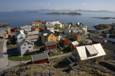
 Hondarribia as seen from Hendaye | |
 Flag  Coat of arms | |
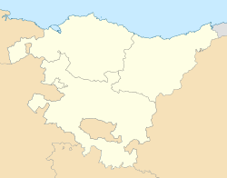 Hondarribia Location of Hondarribia within the Basque Country  Hondarribia Hondarribia (Spain) | |
| Coordinates: 43°22′00″N 1°47′45″W | |
| Country | Spain |
| Autonomous community | |
| Province | Gipuzkoa |
| Eskualdea | Bidasoaldea |
| Founded | April 18, 1203 |
| Government | |
| • Mayor | Txomin Sagarzazu (EAJ-PNV) |
| Area | |
| • Total | 28.63 km2 (11.05 sq mi) |
| Elevation | 16 m (52 ft) |
| Highest elevation | 543 m (1,781 ft) |
| Lowest elevation | 0 m (0 ft) |
| Population (2018)[1] | |
| • Total | 17,018 |
| • Density | 590/km2 (1,500/sq mi) |
| Demonym(s) | Basque: hondarribiar Spanish: fuenterribense |
| Time zone | UTC+1 (CET) |
| • Summer (DST) | UTC+2 (CEST) |
| Postal code | 20280 |
| Official language(s) | Basque, Spanish |
| Website | Official website |
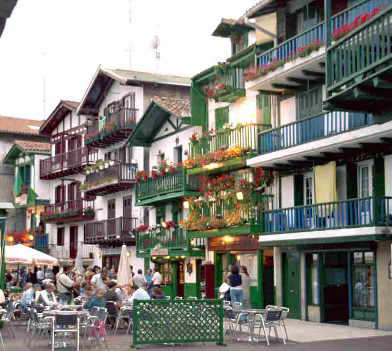
The border town is situated on a little promontory facing Hendaye (France) over the Txingudi bay. A service boat makes the trip between the two cities. The town holds an ancient old quarter with walls and a castle. In addition, Hondarribia features a beach across the Bidasoa from the touristy housing estate Sokoburu in Hendaye, alongside a mountain called Jaizkibel providing a hilly backdrop to the town. A road leads north-east from the beach area to the Cape Higuer, located in this municipality.
The town harbours the San Sebastian Airport, which serves domestic flights. The population as of 2005 is 15,700 inhabitants.
Battles
The battles fought for possession of this fortified stronghold are generally known by the Spanish name for the place (Fuenterrabía).
- Battle of Fuenterrabía (1521), in which Claude, Duke of Guise distinguished himself, was instigated by Guillaume Gouffier, seigneur de Bonnivet, in command of the army of Navarre; he occupied the stronghold after the renewal of hostilities. The city was finally reoccupied by Charles V's forces in 1524 after the first Siege of Fuenterrabía.
- Siege of Fuenterrabía (1638) was the outcome of a siege by the invading forces of Louis XIII, led by Condé. 27,000 French soldiers besieged the city for two months, firing 16,000 shells into the walled city, leaving only 300 survivors, most of them women and children. The city was virtually destroyed, but nevertheless did not surrender.[2] The Spanish soldiers were successful,[citation needed] and the raising of the siege is celebrated annually on 8 September in a parade, known as Alarde.
- Battle of Fuenterrabía (1719), during the War of the Quadruple Alliance, part of the campaign leading to the French Siege of San Sebastian
- Battle of Fuenterrabía (1794), in which the French Revolutionary Army took the city by breaching the walls. After they took over the city, they blew up with the help of German engineers the section of wall facing France.[citation needed] The signing of the Peace of Basel took place before all the wall was destroyed.
Sports
The women's basketball team Hondarribia-Irun and the rowing club Hondarribia Arraun Elkartea are the two most prestigious sports clubs in the town. In the last decade, the judo club Ama Guadalupekoa has had a lot of national medals in this discipline.
The Hondarribia-Irun plays in the Spanish women's basketball league since 2003, and it has competed against European teams several times. Hondarribia has a rowing team called Hondarribia Arraun Elkartea, and its boat is characterized by its green color and its name, “Ama Guadalupekoa”. In 2005 it won “La Bandera de la Concha”, one of the most prestigious competitions for Basque rowers.
Furthermore, the Vilariño family, which is fully linked to the world of the engine, continues to achieve success at national and European levels.
Hondarribia has its own golf course where Jose Maria Olazabal, one of the best golf players in the world, was raised, and marina, where the Olympic medalist Iker Martinez took his first boat roads.[clarification needed]
Leisure

- The construction of a jetty and other ancillary works by the engineer Iribarren, created the beach (hondartza) of Hondarribia that provides a place to enjoy the waters of the bay. In the late twentieth century the beach was partially modified, building on its surroundings a recreational port and a sports center.
- Throughout the year, but especially in the summer months, Arma Plaza Fundazioa (municipal foundation) organizes guided visits to the old town, the port-quarter of the Marina and the Fort of Guadalupe.
- The tourist office also managed by Arma Plaza Fundazioa, located in the Plaza de Armas, incorporates an interpretation center with spaces for audiovisual presentations / temporary exhibitions and souvenirs of the city.
Climate
| Climate data for San Sebastián Airport, Hondarribia (1981–2010 normals) | |||||||||||||
|---|---|---|---|---|---|---|---|---|---|---|---|---|---|
| Month | Jan | Feb | Mar | Apr | May | Jun | Jul | Aug | Sep | Oct | Nov | Dec | Year |
| Record high °C (°F) | 24.6 (76.3) |
28.6 (83.5) |
29.0 (84.2) |
32.4 (90.3) |
36.6 (97.9) |
39.8 (103.6) |
40.4 (104.7) |
40.0 (104.0) |
38.0 (100.4) |
33.4 (92.1) |
29.4 (84.9) |
26.0 (78.8) |
40.4 (104.7) |
| Average high °C (°F) | 13.1 (55.6) |
13.8 (56.8) |
16.1 (61.0) |
17.5 (63.5) |
20.7 (69.3) |
23.1 (73.6) |
25.1 (77.2) |
25.7 (78.3) |
24.0 (75.2) |
21.0 (69.8) |
16.2 (61.2) |
13.5 (56.3) |
19.2 (66.6) |
| Daily mean °C (°F) | 8.9 (48.0) |
9.4 (48.9) |
11.6 (52.9) |
13.0 (55.4) |
16.2 (61.2) |
19.0 (66.2) |
21.0 (69.8) |
21.5 (70.7) |
19.4 (66.9) |
16.4 (61.5) |
12.0 (53.6) |
9.6 (49.3) |
14.8 (58.6) |
| Average low °C (°F) | 4.7 (40.5) |
5.0 (41.0) |
7.0 (44.6) |
8.5 (47.3) |
11.8 (53.2) |
14.8 (58.6) |
16.9 (62.4) |
17.2 (63.0) |
14.7 (58.5) |
11.8 (53.2) |
7.8 (46.0) |
5.6 (42.1) |
10.5 (50.9) |
| Record low °C (°F) | −12.0 (10.4) |
−13.0 (8.6) |
−5.2 (22.6) |
−1.2 (29.8) |
3.0 (37.4) |
5.3 (41.5) |
7.8 (46.0) |
8.4 (47.1) |
4.6 (40.3) |
0.8 (33.4) |
−5.8 (21.6) |
−8.4 (16.9) |
−13.0 (8.6) |
| Average precipitation mm (inches) | 157 (6.2) |
135 (5.3) |
124 (4.9) |
156 (6.1) |
120 (4.7) |
95 (3.7) |
85 (3.3) |
117 (4.6) |
132 (5.2) |
167 (6.6) |
188 (7.4) |
174 (6.9) |
1,649 (64.9) |
| Average precipitation days (≥ 1 mm) | 13 | 12 | 12 | 14 | 12 | 10 | 9 | 10 | 10 | 12 | 13 | 12 | 138 |
| Average snowy days | 1 | 1 | 0 | 0 | 0 | 0 | 0 | 0 | 0 | 0 | 0 | 0 | 2 |
| Average relative humidity (%) | 75 | 72 | 70 | 71 | 72 | 73 | 74 | 75 | 75 | 75 | 76 | 75 | 74 |
| Mean monthly sunshine hours | 88 | 108 | 141 | 159 | 182 | 188 | 198 | 197 | 170 | 134 | 96 | 81 | 1,750 |
| Source: Agencia Estatal de Meteorología[3] | |||||||||||||
Notable residents
- Juan de Alcega (16th century), mathematician and tailor known by his book on geometrical tailoring.
- Josune Amunarriz, prominent female avant-garde artist whose large-scale installations can be seen in San Sebastián, China, and New York.
- Jorge Bolet, legendary American-Cuban pianist
- José María Olazábal famous Spanish golfer, winner of two U.S. Masters titles and regular member of the European Ryder Cup team.
- Unai Emery, winner of Europa League and the former manager of Arsenal, Paris Saint Germain, Sevilla FC, Valencia CF and Spartak Moscow.
- Íñigo Cervantes, professional tennis player
- Itziar Mendizabal, ballet dancer
Old paintings
 Medieval map of Hondarribia.
 Above Hondarribia with its City Walls, and below French Hendaye town in 1640
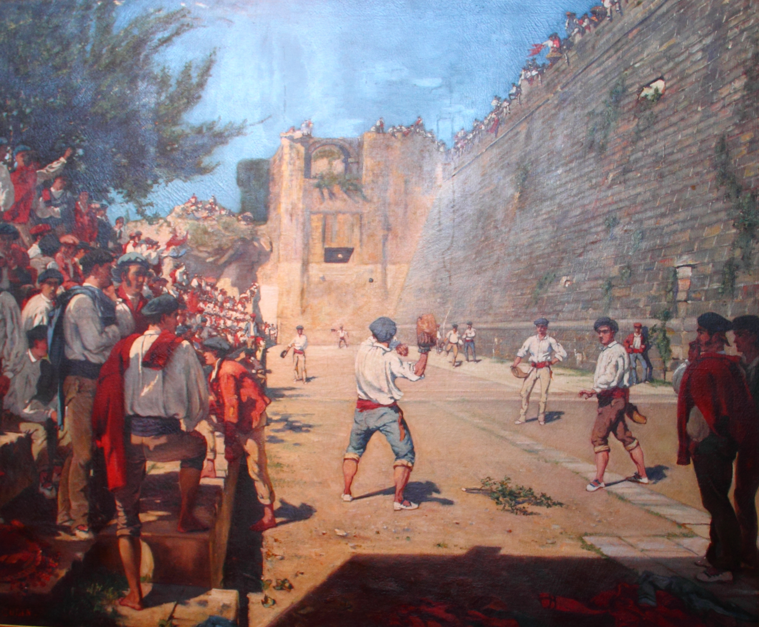
 Basque Pelota's game under the Hondarribia's City Walls, by Gustave Colin in 1863
 Hondarribia by Armand-Dumaresq in 1873
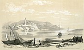 Bidassoa confluence in Fontarrabie, in 1843 by Eugène de Malbos


References
- Municipal Register of Spain 2018. National Statistics Institute.
- Tuwien.ac.at
- "VValores climatológicos normales. Hondarribia, Malkarroa". November 2015.
External links
- Official website (in Basque, English, French, Catalan, and Spanish).
- Hondarribia in the Bernardo Estornes Lasa - Auñamendi Encyclopedia (Euskomedia Fundazioa)
- Tourism in Hondarribia, official website
- Official website of the Pintxos contest, which takes place in Hondarribia
- Santiago Sanchez, et al., "CAAD and historical buildings: the importance of the simulation of the historical process": restoring the walls of Hondarribia
Municipalities in Gipuzkoa | ||
|---|---|---|
|  | |
| |||||||||||||
| |||||||||||||

Authority control | |
|---|---|
| General | |
| National libraries | |
| Other |
|
На других языках
[de] Hondarribia
Hondarribia (spanisch: Fuenterrabía, französisch: Fontarabie) ist eine Stadt im Nordosten der Autonomen Gemeinschaft Baskenland in Spanien. Die zur Provinz Gipuzkoa gehörende Hafenstadt liegt nordwestlich von Irun an der Mündung des Flusses Bidasoa, der hier die Grenze zu Frankreich bildet. Auf der anderen Seite der Flussmündung liegt die französische Stadt Hendaye.- [en] Hondarribia
[es] Fuenterrabía
Fuenterrabía[1][2] (oficialmente y en euskera, Hondarribia) es una ciudad y municipio del País Vasco, España, situado en el extremo noreste de la provincia de Guipúzcoa, a unos 20 km al este de la capital, San Sebastián, en la desembocadura del río Bidasoa, que hace de frontera natural con Hendaya (Francia). Cuenta con una población de 16 852 habitantes (INE 2021). Forma parte de un área metropolitana transfronteriza, la Eurociudad Vasca Bayona-San Sebastián, con más de 620 000 habitantes. Fuenterrabía forma parte de la Eurociudad a través del Consorcio Transfronterizo Bidasoa Txingudi, con las ciudades de Irún y Hendaya. El objetivo de esta cooperación regional es dinamizar proyectos innovadores, atraer inversiones comunes y armonizar un modelo de desarrollo social, territorial y urbano sostenible.[ru] Фуэнтеррабия
Фуэнтерраби́я (исп. Fuenterrabía, баск. Hondarribia, кат. Hondarribia) — населённый пункт и муниципалитет в Испании, входит в провинцию Гипускоа в составе автономного сообщества Страна Басков. Муниципалитет находится в составе района (комарки) Бахо-Бидасоа. Занимает площадь 28,63 км². Население — 16464 человека (на 2010 год). Расстояние до административного центра провинции — 19 км. Располагается на левом берегу устья реки Бидасоа.Другой контент может иметь иную лицензию. Перед использованием материалов сайта WikiSort.org внимательно изучите правила лицензирования конкретных элементов наполнения сайта.
WikiSort.org - проект по пересортировке и дополнению контента Википедии