world.wikisort.org - Spain
Belalcázar is a municipality and city in the province of Córdoba, Andalusia, southern Spain. Belalcázar s located approximately 100 km from Córdoba city.
Belalcázar | |
|---|---|
 Castle of the Sotomayor and Zuñiga. | |
 Flag  Seal | |
 Belalcázar Location in Spain. | |
| Coordinates: 38°34′N 5°10′W | |
| Country | Spain |
| Autonomous community | Andalusia |
| Province | Córdoba |
| Comarca | Los Pedroches |
| Government | |
| • Mayor | Antonio Vigara |
| Area | |
| • Total | 355.99 km2 (137.45 sq mi) |
| Elevation | 488 m (1,601 ft) |
| Population (2018)[1] | |
| • Total | 3,273 |
| • Density | 9.2/km2 (24/sq mi) |
| Demonym(s) | Belalcazareños |
| Time zone | UTC+1 (CET) |
| • Summer (DST) | UTC+2 (CEST) |
| Postal code | 14280 |
| Website | Official website |
Belalcázar is well-known by its cultural heritage: two castles, the convent of Santa Clara, the church of Santiago, the Roman bridge, or the city hall among others.
Main sights
- Castle of the Sotomayor Zúñiga y Madroñiz, in late Gothic style (15th century)
- Castle of Madroñiz
- Convent of Santa Clara de la Columna, founded in 1476[2]
- Parish church of Santiago el Mayor, built from the late 16th century and finished in the 18th century.
Gallery
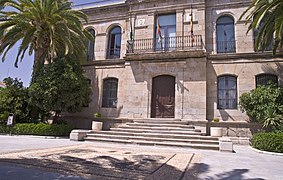 City hall
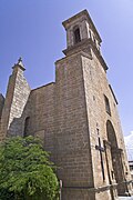 Santiago church
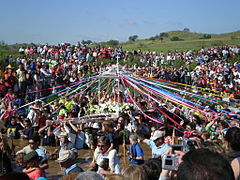 Virgen de la Alcantarilla celebration
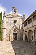 Canta Clara convent
 The castle


Twin towns
 Belalcázar, Colombia[3]
References
- Municipal Register of Spain 2018. National Statistics Institute.
- "Monument Convent of Santa Clara". Patronato Provincial de Turismo de Córdoba. Retrieved 29 December 2013.
- "Archived copy". Archived from the original (PDF) on 2016-03-04. Retrieved 2013-11-06.
{{cite web}}: CS1 maint: archived copy as title (link)
External links
- Belalcázar - Sistema de Información Multiterritorial de Andalucía
Authority control | |
|---|---|
| General | |
| National libraries | |
This article about a location in Andalusia, Spain, is a stub. You can help Wikipedia by expanding it. |
На других языках
- [en] Belalcázar, Spain
[es] Belalcázar
Belalcázar es un municipio español de la provincia de Córdoba, Andalucía. En el año 2018 contaba con 3 273 habitantes. Su extensión superficial es de 355,99 km² y tiene una densidad de 9,37 hab/km². Su término municipal limita; al norte con El Viso y Monterrubio de la Serena; al sur con el de Hinojosa del Duque; al este con El Viso; y al oeste con el de Monterrubio de la Serena. Se encuentra situado en la comarca de Los Pedroches, a una altitud de 488 metros y a 104 kilómetros de la capital de provincia, Córdoba. Hasta 1833 Belalcázar y su comarca formaban parte de Extremadura.[ru] Белалькасар
Белалькасар (исп. Belalcázar) — населённый пункт и муниципалитет в Испании, входит в провинцию Кордова, в составе автономного сообщества Андалусия. Муниципалитет находится в составе района (комарки) Валье-де-лос-Педрочес. Занимает площадь 355 км². Население — 3458 человек (2010). Расстояние — 104 км до административного центра провинции.Текст в блоке "Читать" взят с сайта "Википедия" и доступен по лицензии Creative Commons Attribution-ShareAlike; в отдельных случаях могут действовать дополнительные условия.
Другой контент может иметь иную лицензию. Перед использованием материалов сайта WikiSort.org внимательно изучите правила лицензирования конкретных элементов наполнения сайта.
Другой контент может иметь иную лицензию. Перед использованием материалов сайта WikiSort.org внимательно изучите правила лицензирования конкретных элементов наполнения сайта.
2019-2026
WikiSort.org - проект по пересортировке и дополнению контента Википедии
WikiSort.org - проект по пересортировке и дополнению контента Википедии