world.wikisort.org - South_Africa
Rooiels (Afrikaans equivalent of red alder) is a settlement in Overberg District Municipality in the Western Cape province of South Africa. The name is often written as Rooi-Els, but the name of the township was registered as Rooiels (one word). It was declared a township in June 1948, and is situated 5 km north of Pringle Bay, on the eastern shore of False Bay.[2] It was named after the farm and river by this name.[2]
Rooiels
Rooiels | |
|---|---|
 Rooiels  Rooiels | |
| Coordinates: 34°18′05″S 18°48′59″E | |
| Country | South Africa |
| Province | Western Cape |
| District | Overberg |
| Municipality | Overstrand |
| Area | |
| • Total | 1.15 km2 (0.44 sq mi) |
| Population (2011)[1] | |
| • Total | 125 |
| • Density | 110/km2 (280/sq mi) |
| Racial makeup (2011) | |
| • Black African | 1.6% |
| • White | 92.0% |
| • Other | 6.4% |
| First languages (2011) | |
| • English | 48.8% |
| • Afrikaans | 47.2% |
| • Other | 4.0% |
| Time zone | UTC+2 (SAST) |
It is situated beside the Kogelberg Biosphere Reserve and is itself a registered conservancy.[3] The town roads are narrow, un-tarred and without street lights. Klein-Hangklip mountain dominates the village, and is home to a pair of Verreaux's eagles. Other animals that may be noted are chacma baboons, rock hyrax, small antelope, African clawless otters and occasionally caracal and leopard.[3]
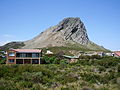 Klein-Hangklip on the eastern edge of False Bay as seen from Rooi-Els
 A whirlpool between the large rocks characteristic for the coast line
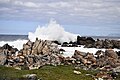 Surf causing high breaking waves at the coastal rocks


References
- "Main Place Rooi-Els". Census 2011.
- Raper, P.E. Dictionary of Southern African Place Names.
- "Accommodation in Rooi-Els". Kogelberg Biosphere Reserve. Archived from the original on 16 September 2011. Retrieved 19 October 2011.
- Note: Another river by this name is situated near Knysna in the southern Cape. The red alder tree does not currently occur near Rooi-Els.
External links
Municipalities and communities of Overberg District Municipality, Western Cape | ||
|---|---|---|
District seat: Bredasdorp | ||
| Cape Agulhas |
|  |
| Overstrand |
| |
| Swellendam | ||
| Theewaterskloof |
| |
Другой контент может иметь иную лицензию. Перед использованием материалов сайта WikiSort.org внимательно изучите правила лицензирования конкретных элементов наполнения сайта.
WikiSort.org - проект по пересортировке и дополнению контента Википедии