world.wikisort.org - South_Africa
Lindequesdrif is an area comprising agricultural holdings, lying between Vanderbijlpark and Potchefstroom, in the far eastern corner of North West province in South Africa.
Lindequesdrif | |
|---|---|
 Lindequesdrif  Lindequesdrif | |
| Coordinates: 26.7572°S 27.5677°E | |
| Country | South Africa |
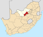
| Province | North West |
| District | Dr Kenneth Kaunda |
| Municipality | JB Marks |
| Area | |
| • Total | 18.04 km2 (6.97 sq mi) |
| Population (2011)[1] | |
| • Total | 1,147 |
| • Density | 64/km2 (160/sq mi) |
| Racial makeup (2011) | |
| • Black African | 50.7% |
| • Coloured | 5.1% |
| • White | 43.4% |
| • Other | 0.8% |
| First languages (2011) | |
| • Afrikaans | 44.8% |
| • Sotho | 24.8% |
| • Tswana | 8.0% |
| • Xhosa | 7.9% |
| • Other | 14.5% |
| Time zone | UTC+2 (SAST) |
It lies on the northern banks of the Vaal River near Sasolburg on the border with the Free State.
References
- "Main Place Lindequesdrif". Census 2011.
Places adjacent to Lindequesdrif | ||||||||||||||||
|---|---|---|---|---|---|---|---|---|---|---|---|---|---|---|---|---|
| ||||||||||||||||
Municipalities and communities of Dr Kenneth Kaunda District Municipality, North West | ||
|---|---|---|
District seat: Klerksdorp | ||
| JB Marks |
|  |
| City of Matlosana |
| |
| Maquassi Hills |
| |
This North West Province location article is a stub. You can help Wikipedia by expanding it. |
Текст в блоке "Читать" взят с сайта "Википедия" и доступен по лицензии Creative Commons Attribution-ShareAlike; в отдельных случаях могут действовать дополнительные условия.
Другой контент может иметь иную лицензию. Перед использованием материалов сайта WikiSort.org внимательно изучите правила лицензирования конкретных элементов наполнения сайта.
Другой контент может иметь иную лицензию. Перед использованием материалов сайта WikiSort.org внимательно изучите правила лицензирования конкретных элементов наполнения сайта.
2019-2025
WikiSort.org - проект по пересортировке и дополнению контента Википедии
WikiSort.org - проект по пересортировке и дополнению контента Википедии