world.wikisort.org - South_Africa
Dominionville is a town in Dr Kenneth Kaunda District Municipality in the North West province of South Africa. Dominionville is named after the mining of the rock called Domino.[2]
Dominionville | |
|---|---|
 Dominionville  Dominionville | |
| Coordinates: 26.900°S 26.394°E | |
| Country | South Africa |
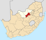
| Province | North West |
| District | Dr Kenneth Kaunda |
| Municipality | City of Matlosana |
| Area | |
| • Total | 1.70 km2 (0.66 sq mi) |
| Population (2011)[1] | |
| • Total | 676 |
| • Density | 400/km2 (1,000/sq mi) |
| Racial makeup (2011) | |
| • Black African | 57.1% |
| • Coloured | 2.4% |
| • Indian/Asian | 0.1% |
| • White | 39.6% |
| • Other | 0.7% |
| First languages (2011) | |
| • Tswana | 46.4% |
| • Afrikaans | 43.0% |
| • English | 5.2% |
| • Xhosa | 2.4% |
| • Other | 3.0% |
| Time zone | UTC+2 (SAST) |
| PO box | 2578 |
| Area code | 018 |
Described as a "ramshackle mining village" by The Globe and Mail, it was built around the Dominion Reefs uranium deposit. The site was acquired in 2005 by Uranium One and at its peak it provided employment for 4,500 workers, but poor labour relations and falling uranium prices led to the mine's closure in October 2009.[3] Shiva Uranium, controlled by the Gupta family, bought the mine for $37 million in 2010.[4]
References
- "Main Place Dominionville". Census 2011.
- "Council's Official Newspaper" (PDF). City Of Matlosana. Archived from the original (PDF) on 3 September 2014. Retrieved 27 August 2014.
- "Backlash emerges against S. Africa's mining industry". The Globe and Mail. Retrieved 27 August 2014.
- "Shiva Plans to Start Uranium Output at South Africa's Dominion `Shortly'". Bloomberg. Retrieved 27 August 2014.
Municipalities and communities of Dr Kenneth Kaunda District Municipality, North West | ||
|---|---|---|
District seat: Klerksdorp | ||
| JB Marks |
|  |
| City of Matlosana |
| |
| Maquassi Hills |
| |
This North West Province location article is a stub. You can help Wikipedia by expanding it. |
Текст в блоке "Читать" взят с сайта "Википедия" и доступен по лицензии Creative Commons Attribution-ShareAlike; в отдельных случаях могут действовать дополнительные условия.
Другой контент может иметь иную лицензию. Перед использованием материалов сайта WikiSort.org внимательно изучите правила лицензирования конкретных элементов наполнения сайта.
Другой контент может иметь иную лицензию. Перед использованием материалов сайта WikiSort.org внимательно изучите правила лицензирования конкретных элементов наполнения сайта.
2019-2025
WikiSort.org - проект по пересортировке и дополнению контента Википедии
WikiSort.org - проект по пересортировке и дополнению контента Википедии